67:
781:
49:
303:, where he finally settled and eventually become mayor. William Blakely Holliday had a major impact on how the township was formed. He purchased land from the Native Americans in 1806 A.D. and eventually owned most of the eastern and northern parts of the township. The Holliday family still resides in North Springfield today.
445:
In the township the population was spread out, with 26.7% under the age of 18, 7.0% from 18 to 24, 29.3% from 25 to 44, 24.8% from 45 to 64, and 12.1% who were 65 years of age or older. The median age was 37 years. For every 100 females, there were 101.8 males. For every 100 females age 18 and over,
405:
of 2000, there were 3,378 people, 1,253 households, and 943 families residing in the township. The population density was 89.6 inhabitants per square mile (34.6/km). There were 1,462 housing units at an average density of 38.8 per square mile (15.0/km). The racial makeup of the township was 97.87%
441:
living together, 10.6% had a female householder with no husband present, and 24.7% were non-families. 20.7% of all households were made up of individuals, and 8.0% had someone living alone who was 65 years of age or older. The average household size was 2.70 and the average family size was 3.11.
66:
1101:
449:
The median income for a household in the township was $ 39,872, and the median income for a family was $ 42,352. Males had a median income of $ 36,491 versus $ 21,786 for females. The
279:, the township has a total area of 37.6 square miles (97.5 km), of which 37.4 square miles (96.8 km) is land and 0.27 square miles (0.7 km), or 0.74%, is water.
714:
19:
1010:
932:
1140:
48:
977:
922:
947:
291:
in the early 19th century and the commerce that resulted from it. A notable example of its past is passage through
Springfield for work related to the canal of
907:
902:
892:
265:
972:
887:
600:
962:
917:
912:
261:
987:
967:
882:
1020:
707:
1060:
1015:
1145:
927:
700:
57:
952:
982:
897:
492:
1055:
551:
937:
692:
411:
942:
415:
1078:
656:
423:
276:
685:
608:
1065:
834:
292:
1050:
1045:
864:
804:
724:
367:
352:
337:
296:
241:
107:
72:
849:
839:
601:"Geographic Identifiers: 2010 Demographic Profile Data (G001): Springfield township, Erie County, Pennsylvania"
226:
437:
There were 1,253 households, out of which 34.3% had children under the age of 18 living with them, 59.9% were
997:
874:
859:
854:
824:
39:
1040:
809:
791:
517:
427:
218:
1085:
1005:
844:
829:
819:
799:
431:
207:
1030:
814:
765:
757:
419:
407:
248:, United States. The population was 3,077 at the 2020 census, down from 3,425 at the 2010 census.
770:
746:
630:
453:
for the township was $ 17,389. About 6.6% of families and 9.3% of the population were below the
571:
450:
197:
583:
466:
287:
Springfield's early history and development was tied to the construction of New York's
269:
1134:
256:
Springfield
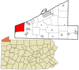
Township is at the western end of Erie County, bordered to the north by
454:
245:
97:
76:
739:
472:
288:
92:
1116:
1103:
257:
188:
53:
676:'Wisconsin Blue Book 1895,' Biographical Sketch of Caleb C. Harris, pg. 693
457:, including 9.9% of those under age 18 and 11.1% of those age 65 or over.
438:
300:
402:
518:"Thornton Junction Topo Map, Erie County PA (East Springfield Area)"
214:
193:
696:
469:, Wisconsin physician and politician, was born in the township.
779:
475:, American civil rights activist, was born in the township.
652:
18:
545:
543:
541:
539:
1029:
996:
873:
790:
756:
225:
204:
187:
179:
171:
163:
158:
150:
142:
134:
126:
118:
113:
103:
91:
83:
30:
20:
Springfield
Township, Pennsylvania (disambiguation)
708:
595:
593:
8:
552:"City and Town Population Totals: 2020-2023"
512:
510:
715:
701:
693:
434:of any race were 0.56% of the population.
310:
27:
484:
224:
186:
157:
149:
141:
112:
82:
63:
45:
25:Township in Pennsylvania, United States
1141:Townships in Erie County, Pennsylvania
579:
569:
330:
203:
178:
170:
162:
133:
130:37.38 sq mi (96.82 km)
125:
122:37.66 sq mi (97.55 km)
117:
102:
90:
7:
607:. U.S. Census Bureau. Archived from
426:, and 0.77% from two or more races.
295:, a former farmer and teacher from
138:0.28 sq mi (0.73 km)
723:Municipalities and communities of
631:"Census of Population and Housing"
320:
58:David M. Roderick Wildlife Reserve
14:
299:, who was making his way west to
268:, and to the west by the city of
65:
47:
1:
495:. United States Census Bureau
657:United States Census Bureau
493:"2016 U.S. Gazetteer Files"
277:United States Census Bureau
183:88.92/sq mi (34.33/km)
172: • Estimate
1162:
293:James Hutchinson Woodworth
17:
1146:Townships in Pennsylvania
1074:
1021:Penn State Erie (Behrend)
777:
737:
726:Erie County, Pennsylvania
394:
381:
366:
351:
336:
329:
324:
319:
316:
297:Onondaga County, New York
64:
46:
37:
446:there were 102.6 males.
154:572 ft (174 m)
146:890 ft (270 m)
56:bluffs as seen from the
784:
143:Highest elevation
75:and the U.S. state of
1117:41.96667°N 80.50806°W
1016:Northwest Harborcreek
783:
653:"U.S. Census website"
395:U.S. Decennial Census
312:Historical population
206: • Summer (
151:Lowest elevation
1087:United States portal
686:Jean Graetz-obituary
611:on February 13, 2020
238:Springfield Township
180: • Density
32:Springfield Township
1122:41.96667; -80.50806
1113: /
1080:Pennsylvania portal
605:American Factfinder
550:Bureau, US Census.
313:
785:
582:has generic name (
558:. US Census Bureau
311:
264:, to the south by
164: • Total
135: • Water
119: • Total
1096:
1095:
1056:North Springfield
451:per capita income
399:
398:
275:According to the
266:Conneaut Township
260:, to the east by
240:is a township in
235:
234:
127: • Land
1153:
1128:
1127:
1125:
1124:
1123:
1118:
1114:
1111:
1110:
1109:
1106:
1088:
1081:
782:
749:
742:
732:
727:
717:
710:
703:
694:
688:
683:
677:
674:
668:
667:
665:
663:
649:
643:
642:
640:
638:
627:
621:
620:
618:
616:
597:
588:
587:
581:
577:
575:
567:
565:
563:
547:
534:
533:
531:
529:
514:
505:
504:
502:
500:
489:
412:African American
332:
327:
322:
314:
211:
69:
51:
28:
1161:
1160:
1156:
1155:
1154:
1152:
1151:
1150:
1131:
1130:
1121:
1119:
1115:
1112:
1107:
1104:
1102:
1100:
1099:
1097:
1092:
1086:
1079:
1070:
1032:
1025:
992:
869:
786:
780:
775:
752:
747:
740:
733:
730:
725:
721:
691:
684:
680:
675:
671:
661:
659:
651:
650:
646:
636:
634:
629:
628:
624:
614:
612:
599:
598:
591:
578:
568:
561:
559:
549:
548:
537:
527:
525:
524:. Locality, LLC
516:
515:
508:
498:
496:
491:
490:
486:
482:
467:Caleb C. Harris
463:
439:married couples
416:Native American
325:
309:
285:
262:Girard Township
254:
205:
79:
60:
42:
33:
26:
23:
12:
11:
5:
1159:
1157:
1149:
1148:
1143:
1133:
1132:
1094:
1093:
1091:
1090:
1083:
1075:
1072:
1071:
1069:
1068:
1063:
1058:
1053:
1048:
1043:
1037:
1035:
1031:Unincorporated
1027:
1026:
1024:
1023:
1018:
1013:
1008:
1002:
1000:
994:
993:
991:
990:
985:
980:
975:
970:
965:
960:
955:
950:
945:
940:
935:
930:
925:
920:
915:
910:
905:
900:
895:
890:
885:
879:
877:
871:
870:
868:
867:
862:
857:
852:
847:
842:
837:
832:
827:
822:
817:
812:
807:
802:
796:
794:
788:
787:
778:
776:
774:
773:
768:
762:
760:
754:
753:
738:
735:
734:
722:
720:
719:
712:
705:
697:
690:
689:
678:
669:
644:
622:
589:
535:
506:
483:
481:
478:
477:
476:
470:
462:
461:Notable people
459:
397:
396:
392:
391:
388:
386:
383:
379:
378:
375:
373:
370:
364:
363:
360:
358:
355:
349:
348:
345:
343:
340:
334:
333:
328:
323:
318:
308:
305:
284:
281:
270:Conneaut, Ohio
253:
250:
233:
232:
229:
223:
222:
212:
202:
201:
191:
185:
184:
181:
177:
176:
173:
169:
168:
165:
161:
160:
156:
155:
152:
148:
147:
144:
140:
139:
136:
132:
131:
128:
124:
123:
120:
116:
115:
111:
110:
105:
101:
100:
95:
89:
88:
85:
81:
80:
70:
62:
61:
52:
44:
43:
38:
35:
34:
31:
24:
13:
10:
9:
6:
4:
3:
2:
1158:
1147:
1144:
1142:
1139:
1138:
1136:
1129:
1126:
1089:
1084:
1082:
1077:
1076:
1073:
1067:
1064:
1062:
1059:
1057:
1054:
1052:
1049:
1047:
1044:
1042:
1039:
1038:
1036:
1034:
1028:
1022:
1019:
1017:
1014:
1012:
1011:Lawrence Park
1009:
1007:
1004:
1003:
1001:
999:
995:
989:
986:
984:
981:
979:
976:
974:
971:
969:
966:
964:
961:
959:
956:
954:
951:
949:
946:
944:
941:
939:
936:
934:
933:Lawrence Park
931:
929:
926:
924:
921:
919:
916:
914:
911:
909:
906:
904:
901:
899:
896:
894:
891:
889:
886:
884:
881:
880:
878:
876:
872:
866:
863:
861:
858:
856:
853:
851:
848:
846:
843:
841:
838:
836:
833:
831:
828:
826:
823:
821:
818:
816:
813:
811:
808:
806:
803:
801:
798:
797:
795:
793:
789:
772:
769:
767:
764:
763:
761:
759:
755:
751:
750:
743:
736:
731:United States
728:
718:
713:
711:
706:
704:
699:
698:
695:
687:
682:
679:
673:
670:
658:
654:
648:
645:
632:
626:
623:
610:
606:
602:
596:
594:
590:
585:
573:
557:
553:
546:
544:
542:
540:
536:
523:
519:
513:
511:
507:
494:
488:
485:
479:
474:
471:
468:
465:
464:
460:
458:
456:
452:
447:
443:
440:
435:
433:
429:
425:
422:, 0.27% from
421:
417:
413:
409:
404:
393:
389:
387:
384:
380:
376:
374:
371:
369:
365:
361:
359:
356:
354:
350:
346:
344:
341:
339:
335:
315:
306:
304:
302:
298:
294:
290:
282:
280:
278:
273:
271:
267:
263:
259:
251:
249:
247:
243:
239:
230:
228:
220:
216:
213:
209:
199:
195:
192:
190:
182:
174:
166:
153:
145:
137:
129:
121:
109:
106:
99:
96:
94:
87:United States
86:
78:
74:
68:
59:
55:
50:
41:
36:
29:
21:
16:
1098:
1066:Sterrettania
957:
835:Mill Village
745:
681:
672:
660:. Retrieved
647:
635:. Retrieved
633:. Census.gov
625:
613:. Retrieved
609:the original
604:
580:|last1=
560:. Retrieved
555:
528:September 5,
526:. Retrieved
521:
497:. Retrieved
487:
455:poverty line
448:
444:
436:
400:
307:Demographics
286:
274:
255:
246:Pennsylvania
237:
236:
98:Pennsylvania
77:Pennsylvania
71:Location in
15:
1120: /
1051:Little Hope
1046:Harborcreek
1033:communities
958:Springfield
928:Harborcreek
865:Wesleyville
805:Cranesville
741:County seat
662:January 31,
473:Jean Graetz
424:other races
382:2023 (est.)
242:Erie County
73:Erie County
1135:Categories
1108:80°30′29″W
1105:41°58′00″N
1061:State Line
978:Washington
953:North East
923:Greenfield
850:Union City
840:North East
556:Census.gov
499:August 13,
480:References
401:As of the
289:Erie Canal
159:Population
983:Waterford
948:Millcreek
898:Elk Creek
875:Townships
860:Wattsburg
855:Waterford
825:Lake City
615:March 22,
258:Lake Erie
252:Geography
227:Area code
189:Time zone
54:Lake Erie
1041:Arbuckle
908:Franklin
903:Fairview
893:Conneaut
810:Edinboro
792:Boroughs
572:cite web
522:TopoZone
428:Hispanic
418:, 0.27%
414:, 0.21%
410:, 0.62%
40:Township
973:Venango
938:LeBoeuf
888:Concord
637:June 4,
562:July 1,
301:Chicago
283:History
84:Country
1006:Avonia
963:Summit
943:McKean
918:Greene
913:Girard
845:Platea
830:McKean
820:Girard
800:Albion
758:Cities
432:Latino
403:census
377:−10.2%
317:Census
104:County
988:Wayne
968:Union
883:Amity
815:Elgin
766:Corry
420:Asian
408:White
390:−2.0%
385:3,015
372:3,077
357:3,425
342:3,378
215:UTC-4
194:UTC-5
175:3,015
167:3,077
93:State
998:CDPs
771:Erie
748:Erie
664:2008
639:2016
617:2016
584:help
564:2024
530:2019
501:2017
368:2020
362:1.4%
353:2010
338:2000
326:Note
321:Pop.
114:Area
108:Erie
430:or
231:814
219:EDT
208:DST
198:EST
1137::
744::
729:,
655:.
603:.
592:^
576::
574:}}
570:{{
554:.
538:^
520:.
509:^
331:%±
272:.
244:,
716:e
709:t
702:v
666:.
641:.
619:.
586:)
566:.
532:.
503:.
347:—
221:)
217:(
210:)
200:)
196:(
22:.
Text is available under the Creative Commons Attribution-ShareAlike License. Additional terms may apply.