48:
62:
87:
816:
827:
851:
94:
69:
705:
800:
736:
720:
710:
921:
858:
265:
911:
795:
741:
382:
762:
664:
946:
695:
629:
594:
669:
574:
534:
359:
634:
624:
619:
599:
715:
549:
464:
584:
579:
454:
674:
639:
544:
519:
659:
609:
589:
564:
554:
539:
529:
514:
494:
469:
459:
449:
679:
654:
559:
499:
479:
474:
444:
434:
614:
569:
509:
484:
439:
270:
126:
746:
644:
524:
489:
86:
700:
649:
604:
504:
61:
916:
412:
397:
931:
892:
352:
428:
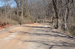
233:. Built in 1835, the road bed has its original width (about 20 feet (6.1 m)) and original embankments. The road is notable as part of the northern route of the
830:
345:
941:
820:
926:
392:
885:
368:
298:
253:
34:
221:. The road is now designated Old Wire Road, and the historic segment runs northward from its junction with County Road 620, northeast of
783:
878:
47:
181:
788:
767:
936:
218:
402:
226:
407:
387:
303:
230:
246:
317:
238:
862:
337:
222:
114:
234:
197:
905:
225:. This road bed is a part of one of the first roads built in the area, running from
801:
University and college buildings listed on the
National Register of Historic Places
859:
property in Benton County, Arkansas on the
National Register of Historic Places
850:
249:. It is the longest known intact segment of the Trail of Tears in Arkansas.
141:
128:
93:
68:
318:"NRHP nomination for Springfield to Fayetteville Road-Cross Hollow Segment"
242:
266:
National
Register of Historic Places listings in Benton County, Arkansas
796:
List of jails and prisons on the
National Register of Historic Places
217:
is a 2-mile (3.2 km) section of a historic 19th-century road in
293:
922:
National
Register of Historic Places in Benton County, Arkansas
341:
912:
Roads on the
National Register of Historic Places in Arkansas
947:
Benton County, Arkansas
Registered Historic Place stubs
866:
271:
215:
27:
245:, and for its use in military operations during the
776:
755:
729:
688:
421:
398:
History of the National Register of Historic Places
375:
203:
190:
180:
165:
157:
120:
110:
429:List of U.S. National Historic Landmarks by state
821:National Register of Historic Places portal
886:
353:
8:
237:, when Native Americans living east of the
917:Buildings and structures completed in 1837
893:
879:
360:
346:
338:
46:
932:Transportation in Benton County, Arkansas
369:U.S. National Register of Historic Places
35:U.S. National Register of Historic Places
282:
241:were forcibly relocated to what is now
294:"National Register Information System"
288:
286:
18:
7:
847:
845:
299:National Register of Historic Places
254:National Register of Historic Places
942:Native American history of Arkansas
252:The road segment was listed on the
865:. You can help Knowledge (XXG) by
784:National Historic Preservation Act
14:
849:
826:
825:
814:
92:
85:
67:
60:
927:1837 establishments in Arkansas
737:Federated States of Micronesia
383:Architectural style categories
192:
1:
101:Show map of the United States
16:United States historic place
186:Cherokee Trail of Tears MPS
963:
844:
789:Historic Preservation Fund
768:American Legation, Morocco
809:
730:Lists by associated state
191:NRHP reference
54:
45:
41:
32:
25:
21:
711:Northern Mariana Islands
323:. Arkansas Preservation
219:Benton County, Arkansas
161:9.9 acres (4.0 ha)
706:Minor Outlying Islands
689:Lists by insular areas
403:Keeper of the Register
227:Fayetteville, Arkansas
857:This article about a
408:National Park Service
388:Contributing property
304:National Park Service
231:Springfield, Missouri
142:36.26500°N 94.11750°W
763:District of Columbia
76:Show map of Arkansas
147:36.26500; -94.11750
138: /
247:American Civil War
874:
873:
839:
838:
393:Historic district
239:Mississippi River
211:
210:
954:
895:
888:
881:
853:
846:
829:
828:
819:
818:
817:
742:Marshall Islands
362:
355:
348:
339:
332:
331:
329:
328:
322:
314:
308:
307:
290:
207:January 19, 2005
194:
176:
174:
153:
152:
150:
149:
148:
143:
139:
136:
135:
134:
131:
115:Lowell, Arkansas
102:
96:
95:
89:
77:
71:
70:
64:
50:
19:
962:
961:
957:
956:
955:
953:
952:
951:
902:
901:
900:
899:
842:
840:
835:
815:
813:
805:
772:
751:
725:
684:
417:
371:
366:
336:
335:
326:
324:
320:
316:
315:
311:
306:. July 9, 2010.
292:
291:
284:
279:
262:
172:
170:
146:
144:
140:
137:
132:
129:
127:
125:
124:
106:
105:
104:
103:
100:
99:
98:
97:
80:
79:
78:
75:
74:
73:
72:
37:
28:
17:
12:
11:
5:
960:
958:
950:
949:
944:
939:
937:Trail of Tears
934:
929:
924:
919:
914:
904:
903:
898:
897:
890:
883:
875:
872:
871:
854:
837:
836:
834:
833:
823:
810:
807:
806:
804:
803:
798:
793:
792:
791:
780:
778:
774:
773:
771:
770:
765:
759:
757:
753:
752:
750:
749:
744:
739:
733:
731:
727:
726:
724:
723:
721:Virgin Islands
718:
713:
708:
703:
698:
696:American Samoa
692:
690:
686:
685:
683:
682:
677:
672:
667:
662:
657:
652:
647:
642:
637:
632:
630:South Carolina
627:
622:
617:
612:
607:
602:
597:
595:North Carolina
592:
587:
582:
577:
572:
567:
562:
557:
552:
547:
542:
537:
532:
527:
522:
517:
512:
507:
502:
497:
492:
487:
482:
477:
472:
467:
462:
457:
452:
447:
442:
437:
432:
425:
423:
422:Lists by state
419:
418:
416:
415:
413:Property types
410:
405:
400:
395:
390:
385:
379:
377:
373:
372:
367:
365:
364:
357:
350:
342:
334:
333:
309:
281:
280:
278:
275:
274:
273:
268:
261:
258:
235:Trail of Tears
209:
208:
205:
201:
200:
195:
188:
187:
184:
178:
177:
167:
163:
162:
159:
155:
154:
122:
118:
117:
112:
108:
107:
91:
90:
84:
83:
82:
81:
66:
65:
59:
58:
57:
56:
55:
52:
51:
43:
42:
39:
38:
33:
30:
29:
26:
23:
22:
15:
13:
10:
9:
6:
4:
3:
2:
959:
948:
945:
943:
940:
938:
935:
933:
930:
928:
925:
923:
920:
918:
915:
913:
910:
909:
907:
896:
891:
889:
884:
882:
877:
876:
870:
868:
864:
860:
855:
852:
848:
843:
832:
824:
822:
812:
811:
808:
802:
799:
797:
794:
790:
787:
786:
785:
782:
781:
779:
775:
769:
766:
764:
761:
760:
758:
754:
748:
745:
743:
740:
738:
735:
734:
732:
728:
722:
719:
717:
714:
712:
709:
707:
704:
702:
699:
697:
694:
693:
691:
687:
681:
678:
676:
673:
671:
670:West Virginia
668:
666:
663:
661:
658:
656:
653:
651:
648:
646:
643:
641:
638:
636:
633:
631:
628:
626:
623:
621:
618:
616:
613:
611:
608:
606:
603:
601:
598:
596:
593:
591:
588:
586:
583:
581:
578:
576:
575:New Hampshire
573:
571:
568:
566:
563:
561:
558:
556:
553:
551:
548:
546:
543:
541:
538:
536:
535:Massachusetts
533:
531:
528:
526:
523:
521:
518:
516:
513:
511:
508:
506:
503:
501:
498:
496:
493:
491:
488:
486:
483:
481:
478:
476:
473:
471:
468:
466:
463:
461:
458:
456:
453:
451:
448:
446:
443:
441:
438:
436:
433:
430:
427:
426:
424:
420:
414:
411:
409:
406:
404:
401:
399:
396:
394:
391:
389:
386:
384:
381:
380:
378:
374:
370:
363:
358:
356:
351:
349:
344:
343:
340:
319:
313:
310:
305:
301:
300:
295:
289:
287:
283:
276:
272:
269:
267:
264:
263:
259:
257:
255:
250:
248:
244:
240:
236:
232:
228:
224:
220:
216:
206:
204:Added to NRHP
202:
199:
196:
189:
185:
183:
179:
168:
164:
160:
156:
151:
123:
119:
116:
113:
109:
88:
63:
53:
49:
44:
40:
36:
31:
24:
20:
867:expanding it
856:
841:
635:South Dakota
625:Rhode Island
620:Pennsylvania
600:North Dakota
325:. Retrieved
312:
297:
251:
214:
212:
111:Nearest city
756:Other areas
716:Puerto Rico
550:Mississippi
465:Connecticut
145: /
121:Coordinates
906:Categories
665:Washington
585:New Mexico
580:New Jersey
455:California
327:2015-03-11
277:References
130:36°15′54″N
675:Wisconsin
640:Tennessee
545:Minnesota
520:Louisiana
256:in 2005.
831:Category
660:Virginia
610:Oklahoma
590:New York
565:Nebraska
555:Missouri
540:Michigan
530:Maryland
515:Kentucky
495:Illinois
470:Delaware
460:Colorado
450:Arkansas
260:See also
243:Oklahoma
198:04001511
133:94°7′3″W
777:Related
680:Wyoming
655:Vermont
560:Montana
500:Indiana
480:Georgia
475:Florida
445:Arizona
435:Alabama
171: (
615:Oregon
570:Nevada
510:Kansas
485:Hawaii
440:Alaska
376:Topics
223:Lowell
861:is a
747:Palau
645:Texas
525:Maine
490:Idaho
321:(PDF)
166:Built
863:stub
701:Guam
650:Utah
605:Ohio
505:Iowa
213:The
173:1837
169:1837
158:Area
229:to
193:No.
182:MPS
908::
302:.
296:.
285:^
894:e
887:t
880:v
869:.
431::
361:e
354:t
347:v
330:.
175:)
Text is available under the Creative Commons Attribution-ShareAlike License. Additional terms may apply.