161:
95:
60:
128:
75:
168:
135:
102:
452:
itself is of Slavic origin - variants of this word in some other Slavic languages are including
Bulgarian "Кръст" ("krst"), Russian "Крест" ("krest"), Ukrainian "Хрест" ("hrest"), etc.
1121:
666:
776:
545:
1116:
711:
196:
94:
580:
343:
160:
59:
686:
529:
769:
45:
127:
762:
556:(1850-1860) within the voivodeship. After the abolishment of the voivodeship in 1860, the village was again included into
476:
313:
336:
74:
588:
572:
553:
549:
533:
467:
The village was mentioned first in 1390. According to some claims, it was mentioned in the 15th century under name
1126:
976:
517:
and the population of the village increased; in 1787 its population numbered 719, and in 1850 1,793 inhabitants.
358:
661:
331:
991:
986:
505:
administration. In 1717, population of the village numbered 4 houses. In 1752, the village was populated by
966:
928:
238:
754:
292:
1052:
898:
807:
786:
374:
302:
255:
739:
1082:
1024:
903:
472:
250:
418:
1019:
908:
865:
592:
495:
933:
705:
612:
608:
576:
541:
521:
510:
502:
410:
1057:
1001:
958:
690:
561:
437:
402:
370:
34:
842:
802:
600:
596:
557:
537:
525:
1077:
568:
491:
1110:
1067:
943:
520:
From 1718 to 1778, the village was part of a separate
Habsburg province known as the
386:
875:
832:
433:
514:
938:
923:
913:
852:
487:
1097:
1034:
918:
885:
837:
619:
584:
405:, the village is known as Српски Крстур / Srpski Krstur (also simply Крстур /
390:
817:
524:. After abolishment of this province, in 1778, the village was included into
211:
198:
981:
870:
860:
626:
622:
378:
283:
243:
948:
812:
1044:
971:
893:
794:
461:
444:("cross" in English), while Hungarian name derived from Hungarian word
49:
460:
Bronze Age graves of south
Russian steppe nomads were found in nearby
1062:
827:
822:
604:
393:
minority (9.38%). It has a population of 1,620 people (2002 census).
366:
309:
288:
231:
540:
from 1774 to 1876. In 1848–1849, the village was part of autonomous
440:
Krstur"). The
Serbian name of the village derived from Serbian word
1072:
1011:
506:
498:. In the middle of the 17th century, the village was uninhabited.
483:
429:
382:
494:. During the Ottoman administration, the village was part of the
1029:
630:
758:
603:. From 1941 to 1944, the village was part of German-occupied
560:. In 1910 census, majority of village inhabitants spoke the
728:
Slobodan Ćurčić, Broj stanovnika
Vojvodine, Novi Sad, 1996.
747:
595:
district. From 1922 to 1929, the village was part of the
471:. In the 14th-15th century, the village was part of the
548:, a separate Habsburg crown land. It was part of the
448:(meaning "cross" in English too). The Hungarian word
1043:
1010:
957:
884:
851:
793:
501:It was repopulated in the 18th century, during the
342:
330:
320:
299:
282:
274:
269:
261:
249:
237:
227:
21:
591:region and also (from 1918 to 1922) part of the
567:In 1918, the village firstly became part of the
532:. The village was also a part of the autonomous
667:List of cities, towns and villages in Vojvodina
607:and was included into the autonomous region of
625:, which (from 1945) was part of new socialist
618:Since 1944, the village is part of autonomous
770:
587:). In 1918–1919, the village was part of the
546:Voivodeship of Serbia and Banat of Temeschwar
26:
8:
528:, which was administratively a part of the
509:, who came from the abolished parts of the
777:
763:
755:
18:
490:, and was subsequently included into the
1122:Populated places in North Banat District
385:ethnic majority (69.81%) with a present
678:
341:
319:
281:
268:
260:
226:
191:
114:Location of Srpski Krstur within Serbia
86:
68:
56:
710:: CS1 maint: archived copy as title (
703:
581:Kingdom of Serbs, Croats and Slovenes
329:
298:
273:
248:
236:
167:
134:
101:
7:
432:Krstur" (There is also a village of
785:Cities, towns and villages in the
599:and from 1929 to 1941 part of the
14:
1117:Populated places in Serbian Banat
482:In 1526-1527 it was part of the
377:, in the Autonomous Province of
166:
159:
133:
126:
100:
93:
73:
58:
362:
27:
1:
744:Official page - Zvaničan sajt
544:and in 1849-1860 part of the
611:, which was governed by its
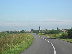
64:The village of Srpski Krstur
16:Village in Vojvodina, Serbia
530:Habsburg Kingdom of Hungary
436:in Vojvodina, meaning "the
1143:
579:, and finally part of the
550:Batschka-Torontal District
534:District of Velika Kikinda
365:) is a village located in
275: • Srpski Krstur
1091:
192:
87:
69:
57:
43:
1098:municipalities or cities
662:List of places in Serbia
589:Banat, Bačka and Baranja
573:Banat, Bačka and Baranja
554:Großbetschkerek District
571:, then (as part of the
265:75 m (246 ft)
740:"Srpski Krstur online"
180:Srpski Krstur (Europe)
147:Srpski Krstur (Serbia)
637:Historical population
301: • Summer (
212:46.11944°N 20.10333°E
117:Show map of Vojvodina
808:Banatsko Veliko Selo
787:North Banat District
575:region) part of the
475:within the medieval
428:Its name means "the
381:. The village has a
375:North Banat District
373:municipality of the
967:Banatsko Aranđelovo
473:Csanadiensis County
208: /
583:(later renamed to
477:Kingdom of Hungary
217:46.11944; 20.10333
183:Show map of Europe
150:Show map of Serbia
1104:
1103:
1053:Banatski Monoštor
577:Kingdom of Serbia
542:Serbian Vojvodina
522:Banat of Temeswar
511:Military Frontier
486:state of Emperor
352:
351:
1134:
779:
772:
765:
756:
751:
746:. Archived from
716:
715:
709:
701:
699:
698:
689:. Archived from
683:
562:Serbian language
552:(1849-1850) and
364:
359:Serbian Cyrillic
306:
223:
222:
220:
219:
218:
213:
209:
206:
205:
204:
201:
184:
170:
169:
163:
151:
137:
136:
130:
118:
104:
103:
97:
77:
62:
38:
30:
29:
19:
1142:
1141:
1137:
1136:
1135:
1133:
1132:
1131:
1107:
1106:
1105:
1100:
1087:
1039:
1006:
953:
909:Vojvoda Zimonić
880:
847:
803:Banatska Topola
789:
783:
738:
735:
725:
723:Further reading
720:
719:
702:
696:
694:
687:"Archived copy"
685:
684:
680:
675:
658:
639:
601:Danube Banovina
597:Belgrade Oblast
593:Veliki Bečkerek
558:Torontal County
538:Torontal County
526:Torontal County
496:Temeşvar Eyalet
458:
399:
326:
300:
216:
214:
210:
207:
202:
199:
197:
195:
194:
188:
187:
186:
185:
182:
181:
178:
177:
176:
175:
171:
154:
153:
152:
149:
148:
145:
144:
143:
142:
138:
121:
120:
119:
116:
115:
112:
111:
110:
109:
105:
83:
82:
81:
80:
65:
53:
39:
32:
24:
17:
12:
11:
5:
1140:
1138:
1130:
1129:
1124:
1119:
1109:
1108:
1102:
1101:
1092:
1089:
1088:
1086:
1085:
1080:
1075:
1070:
1065:
1060:
1055:
1049:
1047:
1041:
1040:
1038:
1037:
1032:
1027:
1022:
1016:
1014:
1008:
1007:
1005:
1004:
999:
994:
989:
984:
979:
974:
969:
963:
961:
955:
954:
952:
951:
946:
941:
936:
931:
926:
921:
916:
911:
906:
901:
896:
890:
888:
882:
881:
879:
878:
873:
868:
863:
857:
855:
849:
848:
846:
845:
840:
835:
830:
825:
820:
815:
810:
805:
799:
797:
791:
790:
784:
782:
781:
774:
767:
759:
753:
752:
750:on 2011-09-04.
734:
733:External links
731:
730:
729:
724:
721:
718:
717:
677:
676:
674:
671:
670:
669:
664:
657:
654:
653:
652:
649:
646:
643:
638:
635:
569:Banat Republic
492:Ottoman Empire
457:
454:
398:
395:
350:
349:
346:
340:
339:
334:
328:
327:
324:
322:
318:
317:
307:
297:
296:
286:
280:
279:
276:
272:
271:
267:
266:
263:
259:
258:
253:
247:
246:
241:
235:
234:
229:
225:
224:
190:
189:
179:
173:
172:
165:
164:
158:
157:
156:
155:
146:
140:
139:
132:
131:
125:
124:
123:
122:
113:
107:
106:
99:
98:
92:
91:
90:
89:
88:
85:
84:
78:
72:
71:
70:
67:
66:
63:
55:
54:
44:
41:
40:
25:
22:
15:
13:
10:
9:
6:
4:
3:
2:
1139:
1128:
1127:Novi Kneževac
1125:
1123:
1120:
1118:
1115:
1114:
1112:
1099:
1095:
1090:
1084:
1081:
1079:
1076:
1074:
1071:
1069:
1066:
1064:
1061:
1059:
1056:
1054:
1051:
1050:
1048:
1046:
1042:
1036:
1033:
1031:
1028:
1026:
1023:
1021:
1018:
1017:
1015:
1013:
1009:
1003:
1000:
998:
997:Srpski Krstur
995:
993:
990:
988:
985:
983:
980:
978:
975:
973:
970:
968:
965:
964:
962:
960:
959:Novi Kneževac
956:
950:
947:
945:
942:
940:
937:
935:
932:
930:
927:
925:
922:
920:
917:
915:
912:
910:
907:
905:
902:
900:
897:
895:
892:
891:
889:
887:
883:
877:
874:
872:
869:
867:
864:
862:
859:
858:
856:
854:
850:
844:
841:
839:
836:
834:
831:
829:
826:
824:
821:
819:
816:
814:
811:
809:
806:
804:
801:
800:
798:
796:
792:
788:
780:
775:
773:
768:
766:
761:
760:
757:
749:
745:
741:
737:
736:
732:
727:
726:
722:
713:
707:
693:on 2011-10-07
692:
688:
682:
679:
672:
668:
665:
663:
660:
659:
655:
650:
647:
644:
641:
640:
636:
634:
632:
628:
624:
621:
616:
614:
610:
606:
602:
598:
594:
590:
586:
582:
578:
574:
570:
565:
563:
559:
555:
551:
547:
543:
539:
535:
531:
527:
523:
518:
516:
512:
508:
504:
499:
497:
493:
489:
485:
480:
478:
474:
470:
465:
463:
455:
453:
451:
447:
443:
439:
435:
431:
426:
424:
420:
416:
415:Srpski Krstur
412:
408:
404:
396:
394:
392:
389:(13.58%) and
388:
384:
380:
376:
372:
371:Novi Kneževac
368:
363:Српски Крстур
360:
356:
355:Srpski Krstur
347:
345:
338:
335:
333:
323:
315:
311:
308:
304:
294:
290:
287:
285:
277:
264:
257:
254:
252:
245:
242:
240:
233:
230:
221:
193:Coordinates:
174:Srpski Krstur
162:
141:Srpski Krstur
129:
108:Srpski Krstur
96:
76:
61:
51:
47:
42:
36:
28:Српски Крстур
23:Srpski Krstur
20:
1093:
996:
833:Novi Kozarci
748:the original
743:
695:. Retrieved
691:the original
681:
617:
566:
519:
500:
481:
469:Papkeresztúr
468:
466:
459:
449:
445:
441:
434:Ruski Krstur
427:
422:
414:
406:
400:
354:
353:
79:Coat of arms
1025:Gornji Breg
939:Totovo Selo
914:Male Pijace
651:1991: 1,552
648:1981: 1,794
645:1971: 2,201
642:1961: 2,415
536:within the
488:Jovan Nenad
321:Postal code
256:North Banat
215: /
1111:Categories
1068:Ostojićevo
944:Trešnjevac
919:Mali Pesak
838:Rusko Selo
697:2012-04-14
673:References
631:Yugoslavia
615:minority.
585:Yugoslavia
423:Ókeresztúr
344:Car plates
337:+381(0)230
270:Population
203:20°06′12″E
200:46°07′10″N
1096:bold are
1083:Crna Bara
982:Podlokanj
929:Novo Selo
871:Sterijino
866:Obornjača
623:Vojvodina
515:Pomorišje
419:Hungarian
417:, and in
391:Hungarian
379:Vojvodina
369:, in the
332:Area code
284:Time zone
262:Elevation
244:Vojvodina
924:Martonoš
706:cite web
656:See also
620:Yugoslav
503:Habsburg
411:Croatian
251:District
239:Province
1035:Tornjoš
1020:Bogaraš
899:Velebit
894:Adorjan
886:Kanjiža
795:Kikinda
629:within
456:History
450:kereszt
446:kereszt
403:Serbian
228:Country
46:Village
35:Serbian
1063:Jazovo
1058:Vrbica
977:Majdan
949:Horgoš
904:Doline
876:Utrine
828:Nakovo
823:Mokrin
813:Bašaid
627:Serbia
613:German
605:Serbia
409:), in
407:Krstur
387:Romani
367:Serbia
232:Serbia
31:
1078:Sanad
1073:Padej
1012:Senta
1002:Filić
992:Siget
843:Sajan
609:Banat
507:Serbs
438:Rusyn
325:23334
310:UTC+2
289:UTC+1
278:1,620
1045:Čoka
1030:Kevi
987:Rabe
972:Đala
934:Orom
818:Iđoš
712:link
484:Serb
462:Đala
442:krst
430:Serb
397:Name
383:Serb
314:CEST
50:Selo
1094:(*)
861:Mol
853:Ada
513:in
421:as
413:as
401:In
303:DST
293:CET
1113::
742:.
708:}}
704:{{
633:.
564:.
479:.
464:.
425:.
361::
348:KI
778:e
771:t
764:v
714:)
700:.
357:(
316:)
312:(
305:)
295:)
291:(
52:)
48:(
37:)
33:(
Text is available under the Creative Commons Attribution-ShareAlike License. Additional terms may apply.