79:
51:
86:
58:
34:
408:
476:
394:
324:
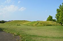
has a characteristic shape, it is unusual is that the square front part is extremely lower than the round rear part. The tumulus is surrounded by an irregularly shaped moat with a width ranging from 10 meters to more than 40 meters in places.
320:. The tumulus has a total length of about 110 meters. The circular portion has a diameter of 63 meters and height of 6.5 meters. The square portion has a width of 37 meters and height of 2.5 meters. While this keyhole-shaped
315:
is located on a natural embankment on the northern bank of the Hirose River at an altitude of about 10 meters, it is the fifth largest tomb in the Tōhoku region and the second largest in Miyagi prefecture after the
356:, and were all found in the east sarcophagus. Only one quartz cylindrical bead, four glass balls and 18 pieces of a black-lacquered bamboo comb were excavated. Fragments of
78:
352:
with two clay sarcophagus which are presumed to have each held a bamboo-shaped wooden coffin. The number of grave goods found was extremely few for the size of the
523:
336:
was excavated by the Sendai City Board of
Education in 1968 and 1972, with further work conducted in 1975 in preparation for the creation of a park. No
421:
518:
375:
also cuts across the site diagonally, truncating one edge of the square portion of the tumulus. The site is now preserved as a public park.
135:
50:
528:
495:
480:
379:
300:
360:
pottery used for ritual purposes were also found. These artifacts are preserved at the Sendai City Museum.
372:
274:
109:
513:
368:
241:
426:
317:
282:
123:
487:
399:
364:
349:
278:
33:
367:, half of the circular portion of the tumulus was destroyed for dirt to expand nearby
507:
293:, or around the late 4th to early 5th century AD, as the tomb of one or more of the
413:
329:
290:
270:
211:
446:
389:
150:
137:
357:
295:
475:
344:
328:
The surrounding area the southern Sendai Plain is noted for extensive
338:
286:
266:
179:
113:
378:
The site is located approximately 3.5 kilometers southeast of
348:
were discovered. The circular mound was found to contain a
230:
222:
217:
207:
199:
194:
186:
174:
166:
129:
119:
105:
299:ruling the Miyagi Plain region. The site is a
257:
8:
289:. It was constructed in the early to middle
19:
453:(in Japanese). Agency for Cultural Affairs
32:
18:
422:List of Historic Sites of Japan (Miyagi)
16:4th or 5th century Japanese burial mound
438:
85:
57:
7:
524:Buildings and structures in Sendai
14:
474:
406:
392:
203:late 4th or early 5th century AD
84:
77:
56:
49:
488:Miyagi Prefecture Official site
242:National Historic Site of Japan
1:
68:Show map of Miyagi Prefecture
519:History of Miyagi Prefecture
545:
496:Sendai City official site
365:under American occupation
258:
238:
43:
31:
24:
451:Cultural Heritage Online
363:In 1947, when Japan was
151:38.238197°N 140.914447°E
529:Historic Sites of Japan
373:Japan National Route 4
301:National Historic Site
170:10 m (33 ft)
110:Wakabayashi-ku, Sendai
93:Tōmizuka Kofun (Japan)
483:at Wikimedia Commons
223:Excavation dates
156:38.238197; 140.914447
369:Kasuminome Air Field
264:is a keyhole-shaped
147: /
21:
231:Public access
479:Media related to
249:
248:
234:Yes (public park}
96:Show map of Japan
536:
500:
492:
478:
463:
462:
460:
458:
447:"遠見塚古墳 とおみづかこふん"
443:
427:Raijinyama Kofun
416:
411:
410:
409:
402:
397:
396:
395:
318:Raijinyama Kofun
275:Wakabayashi ward
263:
261:
260:
162:
161:
159:
158:
157:
152:
148:
145:
144:
143:
140:
97:
88:
87:
81:
69:
60:
59:
53:
36:
22:
544:
543:
539:
538:
537:
535:
534:
533:
504:
503:
498:
490:
472:
467:
466:
456:
454:
445:
444:
440:
435:
412:
407:
405:
398:
393:
391:
388:
309:
277:of the city of
273:located in the
255:
245:
244:
155:
153:
149:
146:
141:
138:
136:
134:
133:
101:
100:
99:
98:
95:
94:
91:
90:
89:
72:
71:
70:
67:
66:
63:
62:
61:
39:
27:
17:
12:
11:
5:
542:
540:
532:
531:
526:
521:
516:
506:
505:
502:
501:
493:
481:Tomizuka Kofun
471:
470:External links
468:
465:
464:
437:
436:
434:
431:
430:
429:
424:
418:
417:
403:
400:History portal
387:
384:
380:Sendai Station
350:burial chamber
308:
305:
279:Sendai, Miyagi
253:Tōmizuka Kofun
247:
246:
240:
239:
236:
235:
232:
228:
227:
224:
220:
219:
215:
214:
209:
205:
204:
201:
197:
196:
192:
191:
188:
184:
183:
176:
172:
171:
168:
164:
163:
131:
127:
126:
121:
117:
116:
107:
103:
102:
92:
83:
82:
76:
75:
74:
73:
65:Tomizuka Kofun
64:
55:
54:
48:
47:
46:
45:
44:
41:
40:
38:Tomizuka Kofun
37:
29:
28:
25:
20:Tomizuka Kofun
15:
13:
10:
9:
6:
4:
3:
2:
541:
530:
527:
525:
522:
520:
517:
515:
512:
511:
509:
499:(in Japanese)
497:
494:
491:(in Japanese)
489:
486:
485:
484:
482:
477:
469:
452:
448:
442:
439:
432:
428:
425:
423:
420:
419:
415:
404:
401:
390:
385:
383:
381:
376:
374:
370:
366:
361:
359:
355:
351:
347:
346:
341:
340:
335:
332:remains. The
331:
326:
323:
319:
314:
311:The Tōmizuka
306:
304:
302:
298:
297:
292:
288:
284:
283:Tōhoku region
280:
276:
272:
269:
268:
254:
243:
237:
233:
229:
225:
221:
216:
213:
210:
206:
202:
198:
193:
189:
185:
182:
181:
177:
173:
169:
165:
160:
132:
128:
125:
124:Tōhoku region
122:
118:
115:
111:
108:
104:
80:
52:
42:
35:
30:
23:
514:Zenpokoenfun
473:
455:. Retrieved
450:
441:
414:Japan portal
377:
362:
353:
343:
337:
333:
330:Yayoi period
327:
321:
312:
310:
294:
291:Kofun period
285:of northern
271:burial mound
265:
252:
250:
212:Kofun period
178:
457:25 December
154: /
142:140°54′52″E
130:Coordinates
508:Categories
433:References
226:1968, 1972
218:Site notes
190:110 meters
139:38°14′18″N
358:Haji ware
386:See also
345:fukiishi
307:Overview
167:Altitude
106:Location
281:in the
208:Periods
200:Founded
195:History
339:haniwa
296:gōzoku
187:Length
120:Region
354:kofun
334:kofun
322:kofun
313:Kofun
287:Japan
267:kofun
259:遠見塚古墳
180:kofun
114:Japan
26:遠見塚古墳
459:2016
251:The
175:Type
342:or
510::
449:.
382:.
371:.
303:.
112:,
461:.
262:)
256:(
Text is available under the Creative Commons Attribution-ShareAlike License. Additional terms may apply.