218:
42:
525:
29:
49:
839:
444:
789:
217:
863:
258:
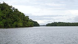
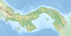
The river starts in highlands of Darien, and runs south/southeast, and then north and west. It runs past villages as it flows downstream including
221:
132:
346:
868:
41:
684:
832:
437:
873:
782:
414:
The
Geology of the Darien, Panama, and the late Miocene-Pliocene collision of the Panama arc with northwestern South America
702:
593:
825:
430:
775:
858:
568:
299:
241:
664:
611:
707:
287:
601:
311:
733:
723:
694:
641:
626:
616:
573:
489:
389:
461:
805:
453:
233:
103:
267:
649:
631:
535:
413:
283:
809:
759:
303:
295:
252:
245:
76:
621:
553:
325:
can be reached. The Púcuro River joins downstream of the Paya, via which the village of
322:
494:
852:
669:
318:
263:
654:
543:
271:
504:
479:
674:
606:
115:
524:
401:
659:
509:
147:
134:
474:
469:
259:
28:
728:
563:
548:
514:
326:
275:
558:
499:
484:
291:
352:(in Spanish). Ministerio de Presidencia-CONADES. 2009. pp. 52–53.
738:
583:
363:
307:
237:
93:
251:
It is the largest river in Panama, and one of its tributaries, the
422:
216:
578:
279:
426:
523:
813:
763:
716:
693:
640:
592:
534:
460:
310:, which is the terminus of the northern end of the
201:
193:
181:
173:
163:
124:
114:
109:
99:
89:
84:
64:
21:
758:This article related to a river in Panama is a
347:"Estategia de desarrollo sostenible de Darién"
833:
783:
438:
317:The Paya River joins the river downstream of
68:
8:
416:, GSA Bulletin (2004) 116 (11-12): 1327–1344
404:, Britannica.com, Retrieved 30 November 2022
185:10,664.42 km (4,117.56 sq mi)
840:
826:
790:
776:
445:
431:
423:
224:maps excerpt showing course of Tuira river
370:. National Geospatial Intelligence Agency
338:
18:
7:
804:This article about the geography of
801:
799:
755:
753:
685:Easternmost point of Central America
306:. Via the Chucunaque, one can reach
48:
812:. You can help Knowledge (XXG) by
762:. You can help Knowledge (XXG) by
255:, is the longest river in Panama.
14:
302:and then flows northwest towards
47:
40:
27:
126: • coordinates
1:
110:Physical characteristics
864:Landforms of Darién Province
165: • elevation
321:, via which the village of
244:at the province capital of
222:U.S. Defense Mapping Agency
890:
798:
752:
390:Panama: Weary repatriation
203: • average
869:North America river stubs
521:
211:
189:
177:230 km (140 mi)
35:
26:
874:Panama geography stubs
708:Inter-American Highway
569:El Real de Santa María
528:
300:El Real de Santa María
225:
69:
703:El Llano – Cartí road
527:
220:
665:Darién National Park
312:Pan-American Highway
240:. It flows into the
169:0 m (0 ft)
144: /
529:
462:Chepigana District
232:is located in the
226:
148:8.3194°N 78.3086°W
821:
820:
771:
770:
747:
746:
650:Bay of San Miguel
594:Santa Fe District
536:Pinogana District
388:(30 April 2008).
242:Bay of San Miguel
215:
214:
56:Location of mouth
881:
859:Rivers of Panama
842:
835:
828:
800:
792:
785:
778:
754:
617:Río Congo Arriba
447:
440:
433:
424:
417:
411:
405:
399:
393:
386:
380:
379:
377:
375:
360:
354:
353:
351:
343:
329:can be reached.
296:Chucunaque River
253:Chucunaque River
204:
159:
158:
156:
155:
154:
153:8.3194; -78.3086
149:
145:
142:
141:
140:
137:
80:
72:
51:
50:
44:
31:
19:
889:
888:
884:
883:
882:
880:
879:
878:
849:
848:
847:
846:
806:Darién Province
797:
796:
750:
748:
743:
712:
689:
636:
588:
530:
519:
456:
454:Darién Province
451:
421:
420:
412:
408:
400:
396:
387:
383:
373:
371:
362:
361:
357:
349:
345:
344:
340:
335:
294:. It meets the
234:Darién Province
202:
166:
152:
150:
146:
143:
138:
135:
133:
131:
130:
127:
104:Darién Province
74:
60:
59:
58:
57:
54:
53:
52:
17:
16:River in Panama
12:
11:
5:
887:
885:
877:
876:
871:
866:
861:
851:
850:
845:
844:
837:
830:
822:
819:
818:
795:
794:
787:
780:
772:
769:
768:
745:
744:
742:
741:
736:
731:
726:
720:
718:
714:
713:
711:
710:
705:
699:
697:
691:
690:
688:
687:
682:
677:
672:
667:
662:
657:
652:
646:
644:
638:
637:
635:
634:
629:
624:
619:
614:
609:
604:
598:
596:
590:
589:
587:
586:
581:
576:
571:
566:
561:
556:
551:
546:
540:
538:
532:
531:
522:
520:
518:
517:
512:
507:
502:
497:
492:
487:
482:
477:
472:
466:
464:
458:
457:
452:
450:
449:
442:
435:
427:
419:
418:
406:
394:
381:
355:
337:
336:
334:
331:
213:
212:
209:
208:
205:
199:
198:
195:
191:
190:
187:
186:
183:
179:
178:
175:
171:
170:
167:
164:
161:
160:
128:
125:
122:
121:
118:
112:
111:
107:
106:
101:
97:
96:
91:
87:
86:
82:
81:
66:
62:
61:
55:
46:
45:
39:
38:
37:
36:
33:
32:
24:
23:
15:
13:
10:
9:
6:
4:
3:
2:
886:
875:
872:
870:
867:
865:
862:
860:
857:
856:
854:
843:
838:
836:
831:
829:
824:
823:
817:
815:
811:
807:
802:
793:
788:
786:
781:
779:
774:
773:
767:
765:
761:
756:
751:
740:
737:
735:
732:
730:
727:
725:
722:
721:
719:
715:
709:
706:
704:
701:
700:
698:
696:
692:
686:
683:
681:
678:
676:
673:
671:
668:
666:
663:
661:
658:
656:
653:
651:
648:
647:
645:
643:
639:
633:
630:
628:
625:
623:
620:
618:
615:
613:
610:
608:
605:
603:
600:
599:
597:
595:
591:
585:
582:
580:
577:
575:
572:
570:
567:
565:
562:
560:
557:
555:
552:
550:
547:
545:
542:
541:
539:
537:
533:
526:
516:
513:
511:
508:
506:
503:
501:
498:
496:
493:
491:
488:
486:
483:
481:
478:
476:
473:
471:
468:
467:
465:
463:
459:
455:
448:
443:
441:
436:
434:
429:
428:
425:
415:
410:
407:
403:
398:
395:
391:
385:
382:
369:
365:
359:
356:
348:
342:
339:
332:
330:
328:
324:
320:
315:
313:
309:
305:
301:
297:
293:
289:
285:
281:
277:
273:
269:
265:
261:
256:
254:
249:
247:
243:
239:
235:
231:
223:
219:
210:
206:
200:
196:
192:
188:
184:
180:
176:
172:
168:
162:
157:
129:
123:
119:
117:
113:
108:
105:
102:
98:
95:
92:
88:
83:
78:
71:
67:
63:
43:
34:
30:
25:
20:
814:expanding it
803:
764:expanding it
757:
749:
679:
655:Bayano Caves
622:Río Iglesias
544:Boca de Cupe
409:
397:
392:, Relief Web
384:
372:. Retrieved
367:
358:
341:
316:
288:Vista Alegre
272:Boca de Cupe
257:
250:
229:
227:
717:Settlements
680:Tuira River
675:Lago Bayano
495:Puerto Piña
402:Tuira River
364:"Rio Tuira"
284:Unión Chocó
236:of eastern
230:Tuira River
151: /
65:Native name
22:Tuira River
853:Categories
670:Darién Gap
660:Bayano Dam
333:References
319:Sobiaquirú
264:Sobiaquirú
182:Basin size
139:78°18′31″W
695:Transport
642:Geography
612:Río Congo
602:Agua Fría
505:Setegantí
480:Garachiné
475:Chepigana
470:Camoganti
282:, Aruza,
268:El Balsal
260:Matuganti
207:363.8 m/s
194:Discharge
136:8°19′10″N
70:Rio Tuira
734:Santa Fe
724:La Palma
632:Zapallal
627:Santa Fe
607:Cucunatí
574:Wargandí
559:Pinogana
490:La Palma
374:July 28,
368:GeoNames
304:La Palma
292:Pinogana
246:La Palma
100:Province
85:Location
510:Taimatí
90:Country
77:Spanish
739:Yaviza
729:Metetí
584:Yaviza
564:Púcuro
549:Metetí
515:Tucutí
327:Púcuro
308:Yaviza
290:, and
276:Capetí
238:Panama
197:
174:Length
120:
94:Panama
73:
808:is a
500:Sambú
485:Jaqué
350:(PDF)
116:Mouth
810:stub
760:stub
579:Yape
554:Paya
376:2021
323:Paya
280:Yape
228:The
314:.
298:at
855::
366:.
286:,
278:,
274:,
270:,
266:,
262:,
248:.
841:e
834:t
827:v
816:.
791:e
784:t
777:v
766:.
446:e
439:t
432:v
378:.
79:)
75:(
Text is available under the Creative Commons Attribution-ShareAlike License. Additional terms may apply.


