531:
29:
263:
203:
252:), to provide salmon access to the newly constructed fish hatchery located immediately above the falls. Prior to the 1952 hatchery operations, the Deschutes river above the Tumwater Falls lacked a natural salmon run.
255:
In 1962, Olympia
Brewing Company donated 15 acres (6.1 ha) of land surrounding the falls to the Olympia-Tumwater Foundation, and Tumwater Falls Park was created. The park receives 200,000 visitors annually.
616:
572:
606:
61:
249:
596:
601:
565:
591:
558:
306:
422:
237:. The plant powered an Olympia–Tumwater streetcar, among other things. A dam at 82 feet (25 m) above sea level created a
262:
611:
159:
129:
54:
441:
538:
368:
269:
226:
510:
385:
328:
222:. A footbridge across the falls was constructed in the 1860s, and the current bridge dates to around 1890.
219:
442:"Hydroelectric power plant of Olympia Light & Power Co., Deschutes River, at Tumwater Falls, Tumwater"
211:
163:
46:
191:
179:
283:
215:
167:
465:
418:
542:
515:
341:
230:
312:
194:
until it reached volcanic bedrock, forming the falls as it coursed down to Puget Sound.
238:
585:
437:
206:
Lower
Tumwater Falls emptying into Capitol Lake adjacent to the old Olympia Brewery
148:
28:
530:
412:
481:
245:
175:
518:
from
Thurston County and cities of Olympia, Lacey and Tumwater's "Stream Team"
511:
U.S. Geological Survey
Geographic Names Information System: Tumwater Falls Dam
329:
U.S. Geological Survey
Geographic Names Information System: Tumwater Falls Dam
244:
The
Tumwater Falls created an impassable barrier to salmon until 1952, when a
171:
77:
63:
202:
190:
The
Deschutes River carved a course through glacial debris left after the
234:
470:, Olympia Historical Society and Bigelow House Museum, October 5, 2014
170:, United States. They are located near where the river empties into
201:
248:
was built by the
Washington Department of Fisheries (now the
147:
For another waterfall sometimes called "Tumwater Falls", see
241:
for the powerhouse and still stands on the
Deschutes River.
516:
A River Flows
Through It: Thurston County’s Deschutes River
225:
Olympia Light and Power Company constructed a dam and a
546:
135:
125:
117:
109:
101:
53:
42:
21:
250:Washington State Department of Fish and Wildlife
448:, University of Washington digital collections
566:
311:, Olympia Tumwater Foundation, archived from
8:
617:Thurston County, Washington geography stubs
411:Lockman, Heather; Wulfsberg, Carla (2010),
573:
559:
362:
360:
324:
322:
229:at the falls in 1890, a decade before the
218:. It was also the site of the now-defunct
27:
18:
488:. Olympia Historical Society. 21 Jun 2015
369:"Tumwater Falls Park Celebrates 50 Years"
607:Landforms of Thurston County, Washington
367:Emmett O'Connell (September 14, 2012),
295:
16:Waterfall in Tumwater, Washington, U.S.
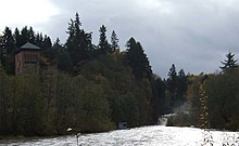
33:Upper Tumwater Falls, pictured in 2007
301:
299:
7:
527:
525:
386:"The Historic Tumwater Falls Bridge"
272:Upper falls from Tumwater Falls Park
214:, the first European settlement in
141:400 cu ft/s (11 m/s)
545:. You can help Knowledge (XXG) by
14:
597:Waterfalls of Washington (state)
529:
261:
158:are a series of cascades on the
210:Tumwater Falls was the site of
134:
124:
108:
100:
602:History of Olympia, Washington
1:
592:Parks in Olympia, Washington
541:state location article is a
539:Thurston County, Washington
414:Images of America: Tumwater
633:
524:
392:. Olympia, WA. 30 Jul 2022
346:Northwest Waterfall Survey
146:
227:hydroelectric power plant
38:
26:
446:Asahel Curtis collection
482:"Fish Ladder - 6/21/15"
467:Olympia Light and Power
220:Olympia Brewing Company
121:25 ft (7.6 m)
417:, Arcadia Publishing,
207:
105:82 ft (25 m)
205:
174:, a southerly arm of
612:Tumwater, Washington
78:47.0147°N 122.9046°W
47:Tumwater, Washington
308:Tumwater Falls Park
233:powerplant outside
192:Pleistocene ice age
73: /
486:Olympiahistory.org
284:History of Olympia
216:Western Washington
208:
83:47.0147; -122.9046
554:
553:
145:
144:
624:
575:
568:
561:
533:
526:
498:
497:
495:
493:
478:
472:
471:
462:
456:
455:
454:
453:
434:
428:
427:
408:
402:
401:
399:
397:
382:
376:
375:
364:
355:
354:
353:
352:
342:"Tumwater Falls"
337:
331:
326:
317:
316:
303:
265:
231:Snoqualmie Falls
97:
96:
94:
93:
92:
90:
85:
84:
79:
74:
71:
70:
69:
66:
31:
19:
632:
631:
627:
626:
625:
623:
622:
621:
582:
581:
580:
579:
522:
507:
502:
501:
491:
489:
480:
479:
475:
464:
463:
459:
451:
449:
436:
435:
431:
425:
410:
409:
405:
395:
393:
384:
383:
379:
366:
365:
358:
350:
348:
339:
338:
334:
327:
320:
305:
304:
297:
292:
280:
275:
274:
273:
271:
266:
200:
188:
160:Deschutes River
152:
137:
130:Deschutes River
110:Number of drops
88:
86:
82:
80:
76:
75:
72:
67:
64:
62:
60:
59:
34:
17:
12:
11:
5:
630:
628:
620:
619:
614:
609:
604:
599:
594:
584:
583:
578:
577:
570:
563:
555:
552:
551:
534:
520:
519:
513:
506:
505:External links
503:
500:
499:
473:
457:
429:
423:
403:
377:
356:
332:
318:
294:
293:
291:
288:
287:
286:
279:
276:
268:
267:
260:
259:
258:
199:
196:
187:
184:
156:Tumwater Falls
143:
142:
139:
133:
132:
127:
123:
122:
119:
115:
114:
111:
107:
106:
103:
99:
98:
89:Tumwater Falls
57:
51:
50:
44:
40:
39:
36:
35:
32:
24:
23:
22:Tumwater Falls
15:
13:
10:
9:
6:
4:
3:
2:
629:
618:
615:
613:
610:
608:
605:
603:
600:
598:
595:
593:
590:
589:
587:
576:
571:
569:
564:
562:
557:
556:
550:
548:
544:
540:
535:
532:
528:
523:
517:
514:
512:
509:
508:
504:
487:
483:
477:
474:
469:
468:
461:
458:
447:
443:
439:
438:Asahel Curtis
433:
430:
426:
424:9780738581279
420:
416:
415:
407:
404:
391:
390:Thurston Talk
387:
381:
378:
374:
373:Thurston Talk
370:
363:
361:
357:
347:
343:
336:
333:
330:
325:
323:
319:
315:on 2015-02-11
314:
310:
309:
302:
300:
296:
289:
285:
282:
281:
277:
270:
264:
257:
253:
251:
247:
242:
240:
236:
232:
228:
223:
221:
217:
213:
204:
197:
195:
193:
185:
183:
181:
177:
173:
169:
165:
161:
157:
150:
140:
131:
128:
120:
116:
112:
104:
95:
58:
56:
52:
48:
45:
41:
37:
30:
25:
20:
547:expanding it
536:
521:
490:. Retrieved
485:
476:
466:
460:
450:, retrieved
445:
432:
413:
406:
394:. Retrieved
389:
380:
372:
349:, retrieved
345:
340:Bryan Swan,
335:
313:the original
307:
254:
243:
224:
209:
189:
155:
153:
149:Celilo Falls
118:Longest drop
102:Total height
440:(c. 1906),
246:fish ladder
176:Puget Sound
126:Watercourse
81: /
68:122°54′17″W
55:Coordinates
586:Categories
452:2015-07-06
351:2015-07-06
290:References
212:New Market
172:Budd Inlet
168:Washington
87: (
65:47°00′53″N
138:flow rate
278:See also
164:Tumwater
43:Location
235:Seattle
198:History
186:Geology
180:Olympia
136:Average
421:
49:, U.S.
537:This
492:9 Apr
396:9 Apr
543:stub
494:2024
419:ISBN
398:2024
239:head
154:The
178:in
162:in
588::
484:.
444:,
388:.
371:,
359:^
344:,
321:^
298:^
182:.
166:,
574:e
567:t
560:v
549:.
496:.
400:.
151:.
113:2
91:)
Text is available under the Creative Commons Attribution-ShareAlike License. Additional terms may apply.