43:
271:
742:
733:
1258:
1359:
27:
256:
530:
50:
444:
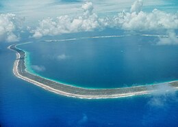
Tureia atoll is 15 km long and has a maximum width of 8 kilometres (5.0 miles); its total land area is 8 km2. A very long island covers completely its eastern reef. The lagoon has no navigable entrance.
619:
42:
1400:
582:
344:
1429:
1393:
1424:
290:
408:
French Land
Register data, which excludes lakes, ponds, glaciers > 1 km (0.386 sq mi or 247 acres) and river estuaries.
469:
705:
88:
1386:
477:
741:
732:
655:
1419:
1257:
1282:
488:
594:
270:
1040:
978:
683:
636:
349:
1277:
854:
698:
637:
Décret n°72-407 du 17 mai 1972 portant création de communes dans le territoire de la Polynésie française
332:
174:
255:
473:
670:
452:(or Fakamaru) is the only settlement on Tureia, at the northern tip of the atoll. Almost all of the
1287:
460:. The population in this atoll has risen to 275 in 2017; in 1977 there were only 121 inhabitants.
1292:
1241:
665:
246:
198:
1328:
691:
543:
515:
507:
1366:
1302:
1297:
722:
438:
337:
186:
179:
1358:
1333:
1323:
1318:
881:
718:
659:
500:
136:
1370:
1170:
1165:
770:
523:
385:
1413:
1025:
640:
399:
76:
1272:
973:
958:
503:
on Tureia during those years. Currently, both installations have been abandoned.
963:
865:
801:
791:
675:
626:(in French). Institut de la statistique de la Polynésie française. January 2023.
453:
26:
1020:
1014:
999:
849:
796:
547:
496:
392:
305:
292:
103:
90:
1221:
1195:
1160:
1045:
988:
948:
938:
927:
555:
380:
620:"Les résultats du recensement de la population 2022 de Polynésie française"
1338:
1226:
1216:
1155:
1145:
1140:
1129:
1108:
1088:
1072:
1056:
843:
837:
832:
714:
559:
434:
191:
123:
1211:
1200:
1190:
1175:
1124:
1113:
1098:
1083:
1051:
983:
968:
953:
916:
911:
896:
870:
860:
811:
806:
551:
529:
492:
457:
1135:
1119:
1103:
1093:
1067:
1062:
1035:
1030:
1009:
993:
932:
921:
906:
901:
891:
827:
822:
816:
775:
765:
585:[Distribution of the population in French Polynesia in 2017]
325:
622:[Results of the 2022 population census of French Polynesia]
1180:
1150:
943:
886:
780:
528:
430:
1185:
1077:
1004:
876:
785:
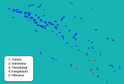
499:, which lie about 115 km south of Tureia. There was also a
260:
687:
760:
583:"Répartition de la population en Polynésie française en 2017"
533:
Map of Tureia Atoll, Tuamotu
Archipelago, French Polynesia
1374:
591:
Institut de la statistique de la Polynésie française
468:
The first recorded
European to arrive at Tureia was
1265:
749:
483:From 1966 to 1999, Tureia hosted an outpost of the
391:
379:
371:
363:
355:
343:
331:
321:
237:
222:
217:
209:
197:
185:
173:
159:
151:
143:
129:
119:
82:
72:
67:
133:47 km (18 sq mi) (lagoon)
476:. Edwards called the atoll "Carysfort", after
1394:
699:
593:(in French). 14 December 2017. Archived from
546:of Tureia, which also includes the atolls of
542:Administratively Tureia Atoll is part of the
8:
19:
1401:
1387:
753:
706:
692:
684:
234:
25:
18:
577:
575:
571:
390:
378:
362:
354:
320:
285:
267:
252:
506:This atoll has a 900 m-long airstrip (
485:Centre d'Expérimentation du Pacifique
370:
342:
330:
276:
7:
1355:
1353:
487:, the French authority supervising
472:in 1791, during his search for the
232:Commune in French Polynesia, France
456:on Tureia is dedicated to growing
14:
1316:Archipelagos of French Polynesia:
662: (archived December 23, 2010)
478:John Proby, 1st Earl of Carysfort
1430:French Polynesia geography stubs
1369:-related geography article is a
1357:
1256:
740:
731:
269:
254:
48:
41:
135:8 km (3 sq mi) (
676:Pictures of Tureia (in French)
49:
1:
359:8 km (3 sq mi)
1425:Communes of French Polynesia
1373:. You can help Knowledge by
1446:
1352:
187:Administrative subdivision
1311:
1254:
1235:
756:
729:
526:was inaugurated in 1985.
407:
286:
277:
268:
253:
244:
164:
36:
24:
16:Atoll in French Polynesia
491:on the nearby atolls of
306:20.771228°S 138.564828°W
147:15 km (9.3 mi)
656:Tureia at OceanDots.com
311:-20.771228; -138.564828
1420:Atolls of the Tuamotus
671:Atoll list (in French)
534:
470:Captain Edward Edwards
263:image of Tureia Atoll.
104:20.77111°S 138.56472°W
1244:administration centre
532:
375:33/km (84/sq mi)
333:Overseas collectivity
175:Overseas collectivity
155:8 km (5 mi)
109:-20.77111; -138.56472
372: • Density
350:Îles Tuamotu-Gambier
715:Tuamotu Archipelago
435:Tuamotu Archipelago
302: /
100: /
21:
1283:Duke of Gloucester
600:on 24 October 2018
535:
280:Location of Tureia
210:Largest settlement
1382:
1381:
1347:
1346:
1252:
1251:
412:
411:
230:
229:
1437:
1403:
1396:
1389:
1367:French Polynesia
1361:
1354:
1260:
754:
744:
735:
723:French Polynesia
708:
701:
694:
685:
643:
634:
628:
627:
625:
616:
610:
609:
607:
605:
599:
588:
579:
474:Bounty mutineers
439:French Polynesia
427:Carysfort Island
338:French Polynesia
317:
316:
314:
313:
312:
307:
303:
300:
299:
298:
295:
273:
258:
235:
180:French Polynesia
115:
114:
112:
111:
110:
105:
101:
98:
97:
96:
93:
52:
51:
45:
29:
22:
1445:
1444:
1440:
1439:
1438:
1436:
1435:
1434:
1410:
1409:
1408:
1407:
1350:
1348:
1343:
1307:
1261:
1248:
1231:
747:
745:
739:
738:
736:
725:
719:Gambier Islands
712:
681:
660:Wayback Machine
652:
647:
646:
635:
631:
623:
618:
617:
613:
603:
601:
597:
586:
581:
580:
573:
568:
540:
501:weather station
466:
448:The village of
403:
310:
308:
304:
301:
296:
293:
291:
289:
288:
282:
281:
264:
249:
240:
233:
169:
134:
108:
106:
102:
99:
94:
91:
89:
87:
86:
63:
62:
61:
60:
59:
58:
57:
53:
32:
17:
12:
11:
5:
1443:
1441:
1433:
1432:
1427:
1422:
1412:
1411:
1406:
1405:
1398:
1391:
1383:
1380:
1379:
1362:
1345:
1344:
1342:
1341:
1336:
1331:
1326:
1321:
1312:
1309:
1308:
1306:
1305:
1300:
1295:
1290:
1285:
1280:
1278:Disappointment
1275:
1269:
1267:
1263:
1262:
1255:
1253:
1250:
1249:
1247:
1246:
1236:
1233:
1232:
1230:
1229:
1224:
1219:
1214:
1209:
1203:
1198:
1193:
1188:
1183:
1178:
1173:
1171:Tepoto (South)
1168:
1166:Tepoto (North)
1163:
1158:
1153:
1148:
1143:
1138:
1133:
1127:
1122:
1117:
1111:
1106:
1101:
1096:
1091:
1086:
1081:
1075:
1070:
1065:
1060:
1054:
1049:
1043:
1038:
1033:
1028:
1023:
1018:
1012:
1007:
1002:
997:
991:
986:
981:
976:
971:
966:
961:
956:
951:
946:
941:
936:
930:
925:
919:
914:
909:
904:
899:
894:
889:
884:
879:
874:
868:
863:
858:
852:
847:
841:
835:
830:
825:
820:
814:
809:
804:
799:
794:
789:
783:
778:
773:
768:
763:
757:
751:
750:Islands/Atolls
748:
730:
727:
726:
713:
711:
710:
703:
696:
688:
679:
678:
673:
668:
666:Tureia Airport
663:
651:
650:External links
648:
645:
644:
629:
611:
570:
569:
567:
564:
539:
538:Administration
536:
524:Tureia Airport
465:
462:
410:
409:
405:
404:
398:
396:
389:
388:
383:
377:
376:
373:
369:
368:
365:
361:
360:
357:
353:
352:
347:
341:
340:
335:
329:
328:
323:
319:
318:
284:
283:
279:
278:
275:
274:
266:
265:
259:
251:
250:
245:
242:
241:
238:
231:
228:
227:
224:
220:
219:
215:
214:
211:
207:
206:
201:
195:
194:
189:
183:
182:
177:
171:
170:
165:
162:
161:
160:Administration
157:
156:
153:
149:
148:
145:
141:
140:
131:
127:
126:
121:
117:
116:
84:
80:
79:
74:
70:
69:
65:
64:
55:
54:
47:
46:
40:
39:
38:
37:
34:
33:
30:
15:
13:
10:
9:
6:
4:
3:
2:
1442:
1431:
1428:
1426:
1423:
1421:
1418:
1417:
1415:
1404:
1399:
1397:
1392:
1390:
1385:
1384:
1378:
1376:
1372:
1368:
1363:
1360:
1356:
1351:
1340:
1337:
1335:
1332:
1330:
1327:
1325:
1322:
1320:
1317:
1314:
1313:
1310:
1304:
1301:
1299:
1296:
1294:
1291:
1289:
1286:
1284:
1281:
1279:
1276:
1274:
1271:
1270:
1268:
1266:Island groups
1264:
1259:
1245:
1243:
1238:
1237:
1234:
1228:
1225:
1223:
1220:
1218:
1215:
1213:
1210:
1207:
1204:
1202:
1199:
1197:
1194:
1192:
1189:
1187:
1184:
1182:
1179:
1177:
1174:
1172:
1169:
1167:
1164:
1162:
1159:
1157:
1154:
1152:
1149:
1147:
1144:
1142:
1139:
1137:
1134:
1131:
1128:
1126:
1123:
1121:
1118:
1115:
1112:
1110:
1107:
1105:
1102:
1100:
1097:
1095:
1092:
1090:
1087:
1085:
1082:
1079:
1076:
1074:
1071:
1069:
1066:
1064:
1061:
1058:
1055:
1053:
1050:
1047:
1044:
1042:
1039:
1037:
1034:
1032:
1029:
1027:
1024:
1022:
1019:
1016:
1013:
1011:
1008:
1006:
1003:
1001:
998:
995:
992:
990:
987:
985:
982:
980:
977:
975:
972:
970:
967:
965:
962:
960:
957:
955:
952:
950:
947:
945:
942:
940:
937:
934:
931:
929:
926:
923:
920:
918:
915:
913:
910:
908:
905:
903:
900:
898:
895:
893:
890:
888:
885:
883:
880:
878:
875:
872:
869:
867:
864:
862:
859:
856:
853:
851:
848:
845:
842:
839:
836:
834:
831:
829:
826:
824:
821:
818:
815:
813:
810:
808:
805:
803:
800:
798:
795:
793:
790:
787:
784:
782:
779:
777:
774:
772:
769:
767:
764:
762:
759:
758:
755:
752:
743:
734:
728:
724:
720:
716:
709:
704:
702:
697:
695:
690:
689:
686:
682:
677:
674:
672:
669:
667:
664:
661:
657:
654:
653:
649:
642:
638:
633:
630:
621:
615:
612:
596:
592:
584:
578:
576:
572:
565:
563:
561:
557:
553:
549:
545:
537:
531:
527:
525:
521:
517:
513:
509:
504:
502:
498:
494:
490:
489:nuclear tests
486:
481:
479:
475:
471:
463:
461:
459:
455:
451:
446:
442:
440:
436:
432:
428:
424:
420:
417:(also called
416:
406:
401:
397:
394:
387:
384:
382:
374:
366:
358:
351:
348:
346:
339:
336:
334:
327:
324:
315:
287:Coordinates:
272:
262:
257:
248:
243:
236:
225:
221:
216:
212:
208:
205:
202:
200:
196:
193:
190:
188:
184:
181:
178:
176:
172:
168:
163:
158:
154:
150:
146:
142:
138:
132:
128:
125:
122:
118:
113:
85:
81:
78:
77:Pacific Ocean
75:
71:
66:
44:
35:
28:
23:
1375:expanding it
1364:
1349:
1315:
1239:
1205:
974:Matureivavao
959:Marutea Nord
680:
632:
614:
602:. Retrieved
595:the original
590:
541:
519:
511:
505:
484:
482:
467:
449:
447:
443:
426:
422:
418:
414:
413:
395:/Postal code
218:Demographics
203:
166:
1288:King George
964:Marutea Sud
866:Hereheretue
802:Anuanurunga
792:Angakauitai
604:16 November
454:arable land
345:Subdivision
309: /
297:138°33′53″W
137:above water
120:Archipelago
107: /
95:138°33′53″W
83:Coordinates
1414:Categories
1293:Two Groups
1021:Nukutepipi
1015:Nukutavake
1000:Nengonengo
850:Fangataufa
797:Anuanuraro
641:Légifrance
566:References
548:Fangataufa
497:Fangataufa
364:Population
294:20°46′16″S
226:275 (2017)
223:Population
92:20°46′16″S
1334:Societies
1329:Marquesas
1222:Vairaatea
1196:Totegegie
1161:Tenarunga
1046:Puka Puka
989:Motutunga
949:Maria Est
939:Manuhangi
928:Mangareva
556:Tematangi
386:UTC−10:00
381:Time zone
68:Geography
1339:Tuamotus
1324:Gambiers
1319:Australs
1303:Raeffsky
1298:Palliser
1227:Vanavana
1217:Vahitahi
1156:Tenararo
1146:Tematagi
1141:Tekokota
1130:Tatakoto
1109:Takapoto
1089:Rekareka
1073:Ravahere
1057:Rangiroa
844:Fangatau
838:Fakarava
833:Fakahina
746:Gambiers
737:Tuamotus
560:Vanavana
458:coconuts
450:Hakamaru
429:) is an
423:Papakena
419:Papahena
213:Hakamaru
192:Tuamotus
124:Tuamotus
73:Location
1242:commune
1212:Vahanga
1201:Tuanake
1191:Tokorua
1176:Tikehau
1125:Taravai
1114:Takaroa
1099:Tahanea
1084:Reitoru
1052:Pukarua
984:Moruroa
969:Mataiva
954:Marokau
917:Makatea
912:Makaroa
897:Kaukura
871:Hikueru
861:Haraiki
812:Aratika
807:Apataki
771:Akamaru
658:at the
552:Moruroa
544:commune
493:Moruroa
464:History
433:in the
322:Country
247:Commune
199:Commune
1273:Acteon
1206:Tureia
1136:Tauere
1120:Takume
1104:Taiaro
1094:Taenga
1068:Raroia
1063:Raraka
1041:Pinaki
1036:Puaumu
1031:Paraoa
1026:Papuri
1010:Nihiru
994:Napuka
979:Morane
933:Manihi
922:Makemo
907:Makapu
902:Kouaku
892:Kauehi
882:Kamaka
828:Faaite
823:Aukena
817:Arutua
776:Akiaki
766:Ahunui
425:, and
415:Tureia
326:France
239:Tureia
204:Tureia
167:France
144:Length
56:Tureia
31:Tureia
20:Tureia
1365:This
1181:Tikei
1151:Temoe
944:Manui
887:Katiu
781:Amanu
624:(PDF)
598:(PDF)
587:(PDF)
431:atoll
400:98755
393:INSEE
152:Width
1371:stub
1186:Toau
1078:Reao
1005:Niau
877:Hiti
786:Anaa
717:and
606:2023
558:and
520:NTGY
516:ICAO
508:IATA
495:and
356:Area
261:NASA
130:Area
855:Hao
761:Ahe
721:of
522:).
512:ZTA
437:in
367:261
1416::
1240:*
639:,
589:.
574:^
562:.
554:,
550:,
518::
514:,
510::
480:.
441:.
421:,
1402:e
1395:t
1388:v
1377:.
1208:*
1132:*
1116:*
1080:*
1059:*
1048:*
1017:*
996:*
935:*
924:*
873:*
857:*
846:*
840:*
819:*
788:*
707:e
700:t
693:v
608:.
402:/
139:)
Text is available under the Creative Commons Attribution-ShareAlike License. Additional terms may apply.