307:
331:
343:
319:
511:
34:
299:"This feature is an eroded volcanic plug - the most distinctive navigational landmark on the entire North Beach. Tow is derived from a Haida word that rhymes with "cow", and means place of food. Many legends about its origin and the significance of the blowhole at the base of the hill......"
256:
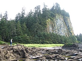
Taaw Tldáaw is the traditional, ancient name of this hill. During the colonial era it was, as the Haida phrase it, "briefly known as Tow Hill". The name Taaw Tldáaw was officially restored in 2022 as part of the Haida's ongoing efforts to reclaim their
280:, but it is not physically part of the range, and is separated from mountainous parts of Graham Island by expanses of forested flatland-marsh and is properly designated as being on the
576:
306:
330:
552:
571:
596:
342:
88:
318:
545:
591:
538:
160:
586:
472:
81:
411:
364:
156:
74:
273:
518:
210:
250:
581:
258:
185:
59:
392:
214:
281:
359:
175:
69:
277:
262:
522:
226:
132:
510:
151:
565:
387:
234:
218:
206:
190:
128:
407:
450:
S. Holland, Landforms of
British Columbia, Bulletin 48, BC Prov Govt, 1976 and 1964
292:
284:, one of the lowland areas of Haida Gwaii not in the Queen Charlotte Mountains.
222:
433:
487:
474:
103:
90:
242:
163:
238:
288:
230:
136:
49:
33:
253:, which covers most of the northeastern flatland of Graham Island.
291:
columns that solidified about two million years ago during the
526:
461:
Queen
Charlotte Islands - Book 2: of places and names
336:
Looking North from Taaw Tldáaw; Alaska on the horizon
184:
174:
169:
150:
142:
124:
119:
80:
68:
58:
48:
43:
21:
312:Looking Northeast from Taaw Tldáaw at North Beach
287:Taaw Tldáaw consists of faceted columnar-jointed
233:, east of McIntyre Bay and near the mouth of the
577:Mountains of British Columbia under 1000 metres
546:
8:
268:Taaw Tldáaw is associated by the editors of
241:, a now-abandoned Haida village and of the
553:
539:
18:
245:, on the site of that village. Formerly
209:located 21 km (13 mi) east of
376:
302:
382:
380:
7:
507:
505:
572:Volcanic plugs of British Columbia
525:. You can help Knowledge (XXG) by
14:
517:This article about a location in
463:; Prince Rupert: Cove Press, 1973
597:British Columbia geography stubs
509:
341:
329:
317:
305:
32:
16:Hill in British Columbia, Canada
276:which in turn form part of the
348:Looking South from Taaw Tldáaw
270:Canadian Mountain Encyclopedia
1:
324:Looking down from Taaw Tldáaw
146:Queen Charlotte Land District
592:Pleistocene British Columbia
243:Hiellen Indian Reserve No. 2
38:Taaw Tldáaw on Graham Island
412:Council of the Haida Nation
365:List of volcanoes in Canada
75:List of volcanoes in Canada
613:
504:
274:Queen Charlotte Mountains
31:
26:
519:British Columbia, Canada
247:Tow Hill Provincial Park
213:on the north end of the
104:54.074194°N 131.798917°W
64:118 m (387 ft)
54:125 m (410 ft)
251:Naikoon Provincial Park
237:, which is the site of
488:54.08333°N 131.80000°W
301:
259:indigenous land rights
205:, is a large isolated
109:54.074194; -131.798917
587:Pleistocene volcanoes
459:Dalzell, Kathleen E;
393:BC Geographical Names
297:
493:54.08333; -131.80000
249:, it is now part of
201:, formerly known as
484: /
408:"Giving Back Names"
360:Volcanism in Canada
100: /
44:Highest point
534:
533:
278:Insular Mountains
215:Naikoon Peninsula
196:
195:
604:
555:
548:
541:
513:
506:
499:
498:
496:
495:
494:
489:
485:
482:
481:
480:
477:
464:
457:
451:
448:
442:
441:
430:
424:
423:
421:
419:
414:. 7 January 2022
404:
398:
397:
384:
345:
333:
321:
309:
227:British Columbia
133:British Columbia
115:
114:
112:
111:
110:
105:
101:
98:
97:
96:
93:
36:
19:
612:
611:
607:
606:
605:
603:
602:
601:
562:
561:
560:
559:
502:
492:
490:
486:
483:
478:
475:
473:
471:
470:
468:
467:
458:
454:
449:
445:
432:
431:
427:
417:
415:
406:
405:
401:
386:
385:
378:
373:
356:
349:
346:
337:
334:
325:
322:
313:
310:
180:2 million years
108:
106:
102:
99:
94:
91:
89:
87:
86:
39:
17:
12:
11:
5:
610:
608:
600:
599:
594:
589:
584:
579:
574:
564:
563:
558:
557:
550:
543:
535:
532:
531:
514:
466:
465:
452:
443:
425:
399:
375:
374:
372:
369:
368:
367:
362:
355:
352:
351:
350:
347:
340:
338:
335:
328:
326:
323:
316:
314:
311:
304:
282:Argonaut Plain
194:
193:
188:
182:
181:
178:
172:
171:
167:
166:
154:
148:
147:
144:
140:
139:
126:
122:
121:
117:
116:
84:
78:
77:
72:
66:
65:
62:
56:
55:
52:
46:
45:
41:
40:
37:
29:
28:
24:
23:
15:
13:
10:
9:
6:
4:
3:
2:
609:
598:
595:
593:
590:
588:
585:
583:
582:Graham Island
580:
578:
575:
573:
570:
569:
567:
556:
551:
549:
544:
542:
537:
536:
530:
528:
524:
520:
515:
512:
508:
503:
500:
497:
462:
456:
453:
447:
444:
439:
435:
429:
426:
413:
409:
403:
400:
395:
394:
389:
388:"Taaw Tldáaw"
383:
381:
377:
370:
366:
363:
361:
358:
357:
353:
344:
339:
332:
327:
320:
315:
308:
303:
300:
296:
294:
290:
285:
283:
279:
275:
271:
266:
264:
260:
254:
252:
248:
244:
240:
236:
235:Hiellen River
232:
228:
224:
220:
219:Graham Island
217:of northeast
216:
212:
208:
207:volcanic plug
204:
200:
192:
191:Volcanic plug
189:
187:
186:Mountain type
183:
179:
177:
173:
168:
165:
162:
158:
155:
153:
149:
145:
141:
138:
134:
130:
129:Graham Island
127:
123:
118:
113:
95:131°47′56.1″W
85:
83:
79:
76:
73:
71:
67:
63:
61:
57:
53:
51:
47:
42:
35:
30:
25:
20:
527:expanding it
516:
501:
469:
460:
455:
446:
437:
428:
416:. Retrieved
402:
391:
298:
286:
269:
267:
255:
246:
202:
198:
197:
92:54°04′27.1″N
491: /
479:131°48′00″W
438:Bivouac.com
293:Pleistocene
263:sovereignty
223:Haida Gwaii
199:Taaw Tldáaw
176:Age of rock
107: /
82:Coordinates
22:Taaw Tldáaw
566:Categories
476:54°05′00″N
434:"Tow Hill"
371:References
60:Prominence
272:with the
120:Geography
50:Elevation
418:18 April
354:See also
203:Tow Hill
164:Tow Hill
152:Topo map
143:District
125:Location
27:Tow Hill
295:epoch.
239:Hiellen
170:Geology
70:Listing
289:basalt
231:Canada
211:Masset
159:
137:Canada
521:is a
161:103J4
523:stub
420:2023
261:and
221:in
157:NTS
568::
436:.
410:.
390:.
379:^
265:.
229:,
225:,
135:,
131:,
554:e
547:t
540:v
529:.
440:.
422:.
396:.
Text is available under the Creative Commons Attribution-ShareAlike License. Additional terms may apply.