26:
314:
174:
passes in the Sierra Nevada range, partly due to the low starting elevation of the Owens Valley
Trailhead in a desert floor, at 5,500 feet. From the trailhead it is an 8-mile hike, gaining 6,000 feet over that distance to reach the pass at 11,400 feet. Some notable peaks near Taboose Pass include:
334:
267:
91:
339:
258:
263:
224:
184:
192:
84:
176:
208:
152:
61:
318:
253:
57:
155:
to the west. The pass is reachable from the east via a long, strenuous hike from the desert floor of the
288:
25:
148:
144:
136:
77:
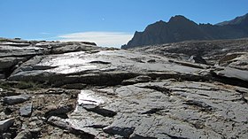
160:
36:
188:
220:
216:
196:
164:
171:
72:
328:
132:
212:
156:
228:
204:
200:
180:
140:
65:
106:
93:
313:
223:, White Mountain (at 12,828', not to be confused with the
335:
Mountain passes of the Sierra Nevada (United States)
83:
71:
53:
45:
35:
18:
127:, 11,417 ft (3,480 m), also known as
8:
170:Taboose Pass is one of the more difficult
15:
268:United States Department of the Interior
240:
248:
246:
244:
7:
259:Geographic Names Information System
159:. On the west, it connects to the
30:Glacial striations at Taboose Pass
14:
312:
24:
264:United States Geological Survey
1:
41:11,417 ft (3,480 m)
356:
340:Kings Canyon National Park
153:Kings Canyon National Park
227:with the same name), and
23:
167:in the National Park.
107:36.98472°N 118.41389°W
291:. U.S. Forest Service
225:California fourteener
143:on the border of the
321:at Wikimedia Commons
289:"Taboose Pass Trail"
149:John Muir Wilderness
145:Inyo National Forest
112:36.98472; -118.41389
161:Pacific Crest Trail
103: /
179:(the southernmost
151:) to the east and
49:Taboose Pass Trail
317:Media related to
219:, Striped South,
189:Cardinal Mountain
122:
121:
347:
316:
300:
299:
297:
296:
285:
279:
278:
276:
275:
250:
221:Vennacher Needle
217:Striped Mountain
197:Goodale Mountain
135:in the southern
118:
117:
115:
114:
113:
108:
104:
101:
100:
99:
96:
28:
16:
355:
354:
350:
349:
348:
346:
345:
344:
325:
324:
309:
304:
303:
294:
292:
287:
286:
282:
273:
271:
252:
251:
242:
237:
193:Crater Mountain
185:Palisades group
165:John Muir Trail
111:
109:
105:
102:
97:
94:
92:
90:
89:
31:
12:
11:
5:
353:
351:
343:
342:
337:
327:
326:
323:
322:
308:
307:External links
305:
302:
301:
280:
254:"Taboose Pass"
239:
238:
236:
233:
177:Split Mountain
172:Eastern Sierra
120:
119:
87:
81:
80:
75:
69:
68:
55:
51:
50:
47:
43:
42:
39:
33:
32:
29:
21:
20:
13:
10:
9:
6:
4:
3:
2:
352:
341:
338:
336:
333:
332:
330:
320:
315:
311:
310:
306:
290:
284:
281:
269:
265:
261:
260:
255:
249:
247:
245:
241:
234:
232:
230:
226:
222:
218:
214:
210:
209:Mount Pinchot
206:
202:
198:
194:
190:
186:
182:
178:
173:
168:
166:
162:
158:
154:
150:
146:
142:
138:
137:Sierra Nevada
134:
133:mountain pass
130:
126:
116:
88:
86:
82:
79:
78:Sierra Nevada
76:
74:
70:
67:
63:
59:
56:
52:
48:
44:
40:
38:
34:
27:
22:
17:
319:Taboose Pass
293:. Retrieved
283:
272:. Retrieved
270:. 1981-01-19
257:
213:Mount Ruskin
169:
157:Owens Valley
128:
125:Taboose Pass
124:
123:
46:Traversed by
19:Taboose Pass
229:Mount Wynne
205:Marion Peak
201:Mount Ickes
110: /
98:118°24′50″W
85:Coordinates
329:Categories
295:2017-09-20
274:2017-09-20
235:References
181:fourteener
141:California
95:36°59′05″N
66:California
64:Counties,
37:Elevation
129:Wide Gap
54:Location
183:in the
131:, is a
62:Fresno
73:Range
60:and
58:Inyo
187:),
331::
266:,
262:.
256:.
243:^
231:.
215:,
211:,
207:,
203:,
199:,
195:,
191:,
139:,
298:.
277:.
163:/
147:(
Text is available under the Creative Commons Attribution-ShareAlike License. Additional terms may apply.