31:
248:
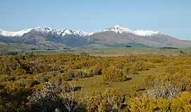
115:. The mountain range is about 30 kilometres (19 mi) long and contains several peaks of around 1,600 metres (5,200 ft) height, with the Brunel Peaks reaching 1,650 metres (5,410 ft).
30:
308:
209:
289:
313:
197:
282:
155:
275:
151:
176:
247:
255:
95:
119:
259:
302:
131:
123:
127:
85:
224:
211:
112:
108:
54:
35:
Takitimu
Mountains from north (Wilderness Scientific Reserve)
263:
91:
81:
76:
68:
63:
53:
45:
40:
23:
200:information panel at Wilderness Scientific Reserve
107:extend in a north–south direction southeast of
283:
152:"Takitimu Mountains, Southland - NZ Topo Map"
8:
122:mythology, the mountain range is special to
290:
276:
126:as it represents the upturned hull of the
20:
134:to the south of the Takitimu Mountains.
309:Mountain ranges of the Southland Region
177:"Brunel Peaks, Southland - NZ Topo Map"
143:
7:
244:
242:
14:
314:Southland Region geography stubs
246:
29:
179:. Land Information New Zealand
1:
16:Mountain range in New Zealand
262:. You can help Knowledge by
156:Land Information New Zealand
59:1,650 m (5,410 ft)
330:
241:
198:Department of Conservation
28:
258:geography article is a
72:30 km (19 mi)
221: /
225:45.750°S 167.800°E
105:Takitimu Mountains
41:Highest point
24:Takitimu Mountains
271:
270:
101:
100:
321:
292:
285:
278:
256:Southland Region
250:
243:
236:
235:
233:
232:
231:
230:-45.750; 167.800
226:
222:
219:
218:
217:
214:
201:
195:
189:
188:
186:
184:
173:
167:
166:
164:
162:
148:
33:
21:
329:
328:
324:
323:
322:
320:
319:
318:
299:
298:
297:
296:
239:
229:
227:
223:
220:
215:
212:
210:
208:
207:
205:
204:
196:
192:
182:
180:
175:
174:
170:
160:
158:
150:
149:
145:
140:
36:
17:
12:
11:
5:
327:
325:
317:
316:
311:
301:
300:
295:
294:
287:
280:
272:
269:
268:
251:
203:
202:
190:
168:
142:
141:
139:
136:
99:
98:
93:
89:
88:
83:
79:
78:
74:
73:
70:
66:
65:
61:
60:
57:
51:
50:
47:
43:
42:
38:
37:
34:
26:
25:
15:
13:
10:
9:
6:
4:
3:
2:
326:
315:
312:
310:
307:
306:
304:
293:
288:
286:
281:
279:
274:
273:
267:
265:
261:
257:
252:
249:
245:
240:
237:
234:
199:
194:
191:
178:
172:
169:
157:
153:
147:
144:
137:
135:
133:
132:Te Waewae Bay
129:
128:Tākitimu waka
125:
121:
116:
114:
110:
106:
97:
94:
90:
87:
84:
80:
75:
71:
67:
62:
58:
56:
52:
48:
44:
39:
32:
27:
22:
19:
264:expanding it
253:
238:
206:
193:
181:. Retrieved
171:
159:. Retrieved
146:
120:Māori people
117:
104:
102:
49:Brunel Peaks
18:
228: /
183:26 November
161:26 November
130:wrecked in
86:New Zealand
303:Categories
138:References
64:Dimensions
124:Ngāi Tahu
113:Manapouri
96:Southland
77:Geography
55:Elevation
216:167°48′E
213:45°45′S
109:Te Anau
82:Country
92:Region
69:Length
254:This
260:stub
185:2018
163:2018
111:and
103:The
46:Peak
118:In
305::
154:.
291:e
284:t
277:v
266:.
187:.
165:.
Text is available under the Creative Commons Attribution-ShareAlike License. Additional terms may apply.