69:
81:
772:
53:
194:
474:
In the township the population was spread out, with 22.6% under the age of 18, 7.8% from 18 to 24, 27.4% from 25 to 44, 27.6% from 45 to 64, and 14.6% who were 65 years of age or older. The median age was 41 years. For every 100 females there were 106.2 males. For every 100 females age 18 and over,
438:
of 2000, there were 2,239 people, 852 households, and 685 families residing in the township. The population density was 96.8 inhabitants per square mile (37.4/km). There were 909 housing units at an average density of 39.3 per square mile (15.2/km). The racial makeup of the township was 98.84%
470:
living together, 5.0% had a female householder with no husband present, and 19.5% were non-families. 17.1% of all households were made up of individuals, and 8.6% had someone living alone who was 65 years of age or older. The average household size was 2.63 and the average family size was 2.95.
68:
478:
The median income for a household in the township was $ 41,635, and the median income for a family was $ 45,795. Males had a median income of $ 30,368 versus $ 23,438 for females. The
710:
899:
1442:
879:
869:
864:
849:
19:
1437:
919:
80:
889:
874:
52:
1302:
914:
904:
884:
1352:
1072:
894:
854:
595:
703:
495:
263:
1177:
1042:
997:
942:
1398:
1342:
1312:
1112:
1237:
1172:
1192:
696:
1447:
1162:
1157:
1092:
519:
226:
113:
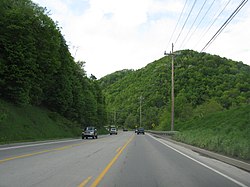
1257:
549:
688:
444:
332:
and Short
Mountain, then curves to the east along the crest of Loop Mountain. Unincorporated places in the township include
1027:
333:
293:
1282:
1152:
1062:
972:
859:
815:
325:
321:
1375:
967:
957:
800:
742:
647:
452:
348:
599:
1332:
1322:
1297:
1147:
1097:
1022:
1017:
1012:
831:
795:
720:
679:
337:
282:
118:
1347:
1182:
1127:
1052:
1047:
987:
977:
962:
952:
805:
400:
385:
1277:
1232:
1227:
1217:
1087:
1077:
1067:
1007:
992:
937:
820:
251:
91:
1272:
1252:
1247:
1222:
1197:
1117:
1107:
1102:
982:
947:
929:
841:
466:
There were 852 households, out of which 30.5% had children under the age of 18 living with them, 72.3% were
278:
43:
596:"Geographic Identifiers: 2010 Demographic Profile Data (G001): Taylor township, Blair County, Pennsylvania"
1317:
1212:
1207:
1187:
1137:
1082:
1057:
1037:
790:
782:
456:
341:
1292:
1122:
1032:
761:
58:
1382:
1327:
1307:
1202:
826:
460:
236:
1287:
1267:
1262:
1242:
1167:
1142:
1132:
810:
753:
448:
440:
1337:
1002:
482:
for the township was $ 18,260. About 0.9% of families and 3.0% of the population were below the
621:
569:
479:
499:
329:
581:
1431:
256:
483:
286:
106:
667:
735:
351:, the township has a total area of 23.4 square miles (60.5 km), all land.
290:
101:
1413:
1400:
217:
1366:‡This populated place also has portions in an adjacent county or counties
486:, including 3.0% of those under age 18 and 6.1% of those age 65 or over.
467:
320:
Taylor
Township is located along the southern border of Blair County;
435:
324:
is to the south. The township completely surrounds the borough of
243:
222:
692:
73:
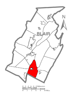
Map of Blair County, Pennsylvania highlighting Taylor
Township
770:
328:. The township's western border follows the ridgecrest of
643:
598:. U.S. Census Bureau, American Factfinder. Archived from
18:
543:
541:
539:
537:
1361:
928:
840:
781:
752:
262:
250:
233:
216:
208:
200:
187:
182:
174:
166:
158:
153:
145:
140:
132:
124:
112:
100:
90:
30:
668:https://viewer.nationalmap.gov/advanced-viewer/
296:. The population was 2,296 at the 2020 census.
20:Taylor Township, Pennsylvania (disambiguation)
704:
670:The National Map, retrieved November 14, 2018
8:
550:"City and Town Population Totals: 2020-2022"
711:
697:
689:
463:of any race were 0.36% of the population.
358:
27:
680:Pennsylvania State Game Lands Number 147
496:Pennsylvania State Game Lands Number 147
1443:Townships in Blair County, Pennsylvania
511:
261:
249:
215:
181:
152:
139:
123:
89:
65:
49:
25:Township in Pennsylvania, United States
577:
567:
378:
232:
207:
199:
186:
173:
170:23.34 sq mi (60.46 km)
165:
162:23.34 sq mi (60.46 km)
157:
144:
131:
111:
99:
77:
7:
1438:Populated places established in 1775
455:, and 0.63% from two or more races.
289:, United States. It is part of the
178:0.00 sq mi (0.00 km)
719:Municipalities and communities of
622:"Census of Population and Housing"
368:
14:
85:Map of Blair County, Pennsylvania
193:
192:
79:
67:
51:
682:, retrieved November 14, 2018
1:
1303:Spring Drive Mobile Home Park
522:. United States Census Bureau
311:Local telephone exchange: 224
294:Metropolitan Statistical Area
212:104.99/sq mi (40.54/km)
648:United States Census Bureau
520:"2016 U.S. Gazetteer Files"
349:United States Census Bureau
201: • Estimate
1464:
722:Blair County, Pennsylvania
17:
1448:Townships in Pennsylvania
1371:
768:
733:
427:
414:
399:
384:
377:
372:
367:
364:
78:
66:
50:
41:
475:there were 101.5 males.
1113:Homewood at Martinsburg
775:
774:
644:"U.S. Census website"
428:U.S. Decennial Census
360:Historical population
235: • Summer (
59:Pennsylvania Route 36
1384:United States portal
1163:Martinsburg Junction
602:on February 12, 2020
209: • Density
149:Board of Supervisors
1410: /
1377:Pennsylvania portal
548:Bureau, US Census.
361:
300:General information
776:
580:has generic name (
556:. US Census Bureau
359:
188: • Total
175: • Water
159: • Total
1393:
1392:
1258:Robeson Extension
480:per capita income
434:According to the
432:
431:
347:According to the
272:
271:
167: • Land
146: • Type
1455:
1425:
1424:
1422:
1421:
1420:
1415:
1411:
1408:
1407:
1406:
1403:
1385:
1378:
773:
745:
738:
728:
723:
713:
706:
699:
690:
683:
677:
671:
665:
659:
658:
656:
654:
640:
634:
633:
631:
629:
618:
612:
611:
609:
607:
592:
586:
585:
579:
575:
573:
565:
563:
561:
545:
532:
531:
529:
527:
516:
500:Dunning Mountain
445:African American
380:
375:
370:
362:
330:Dunning Mountain
240:
196:
195:
83:
71:
55:
32:Taylor Township,
28:
1463:
1462:
1458:
1457:
1456:
1454:
1453:
1452:
1428:
1427:
1418:
1416:
1414:40.32°N 78.41°W
1412:
1409:
1404:
1401:
1399:
1397:
1396:
1394:
1389:
1383:
1376:
1367:
1357:
1028:East Sharpsburg
924:
836:
777:
771:
766:
748:
743:
736:
729:
726:
721:
717:
687:
686:
678:
674:
666:
662:
652:
650:
642:
641:
637:
627:
625:
620:
619:
615:
605:
603:
594:
593:
589:
576:
566:
559:
557:
547:
546:
535:
525:
523:
518:
517:
513:
508:
492:
468:married couples
373:
357:
334:East Sharpsburg
318:
305:ZIP code: 16673
302:
275:Taylor Township
234:
86:
74:
62:
61:in the township
46:
37:
35:
33:
26:
23:
12:
11:
5:
1461:
1459:
1451:
1450:
1445:
1440:
1430:
1429:
1391:
1390:
1388:
1387:
1380:
1372:
1369:
1368:
1365:
1363:
1359:
1358:
1356:
1355:
1353:Yellow Springs
1350:
1345:
1340:
1335:
1330:
1325:
1320:
1315:
1310:
1305:
1300:
1295:
1290:
1285:
1283:Sickles Corner
1280:
1275:
1270:
1265:
1260:
1255:
1250:
1245:
1240:
1235:
1230:
1225:
1220:
1215:
1210:
1205:
1200:
1195:
1190:
1185:
1180:
1175:
1170:
1165:
1160:
1155:
1153:Linds Crossing
1150:
1145:
1140:
1135:
1130:
1125:
1120:
1115:
1110:
1105:
1100:
1095:
1090:
1085:
1080:
1075:
1073:Fredericksburg
1070:
1065:
1063:Franklin Forge
1060:
1055:
1050:
1045:
1040:
1035:
1030:
1025:
1020:
1015:
1010:
1005:
1000:
995:
990:
985:
980:
975:
973:Charlottsville
970:
965:
960:
955:
950:
945:
940:
934:
932:
926:
925:
923:
922:
917:
912:
907:
902:
900:North Woodbury
897:
892:
887:
882:
877:
872:
867:
862:
857:
852:
846:
844:
838:
837:
835:
834:
829:
824:
818:
816:Roaring Spring
813:
808:
803:
798:
793:
787:
785:
779:
778:
769:
767:
765:
764:
758:
756:
750:
749:
734:
731:
730:
718:
716:
715:
708:
701:
693:
685:
684:
672:
660:
635:
613:
587:
533:
510:
509:
507:
504:
498:is located on
491:
488:
430:
429:
425:
424:
421:
419:
416:
412:
411:
408:
406:
403:
397:
396:
393:
391:
388:
382:
381:
376:
371:
366:
356:
353:
326:Roaring Spring
322:Bedford County
317:
314:
313:
312:
309:
308:Area code: 814
306:
301:
298:
270:
269:
266:
260:
259:
254:
248:
247:
241:
231:
230:
220:
214:
213:
210:
206:
205:
202:
198:
197:
189:
185:
184:
180:
179:
176:
172:
171:
168:
164:
163:
160:
156:
155:
151:
150:
147:
143:
142:
138:
137:
134:
130:
129:
126:
122:
121:
116:
110:
109:
104:
98:
97:
94:
88:
87:
84:
76:
75:
72:
64:
63:
56:
48:
47:
42:
39:
38:
31:
24:
13:
10:
9:
6:
4:
3:
2:
1460:
1449:
1446:
1444:
1441:
1439:
1436:
1435:
1433:
1426:
1423:
1419:40.32; -78.41
1386:
1381:
1379:
1374:
1373:
1370:
1364:
1360:
1354:
1351:
1349:
1346:
1344:
1341:
1339:
1336:
1334:
1331:
1329:
1326:
1324:
1321:
1319:
1316:
1314:
1311:
1309:
1306:
1304:
1301:
1299:
1296:
1294:
1291:
1289:
1286:
1284:
1281:
1279:
1276:
1274:
1271:
1269:
1266:
1264:
1261:
1259:
1256:
1254:
1251:
1249:
1246:
1244:
1241:
1239:
1236:
1234:
1231:
1229:
1226:
1224:
1221:
1219:
1216:
1214:
1211:
1209:
1206:
1204:
1201:
1199:
1196:
1194:
1191:
1189:
1186:
1184:
1181:
1179:
1176:
1174:
1171:
1169:
1166:
1164:
1161:
1159:
1156:
1154:
1151:
1149:
1146:
1144:
1141:
1139:
1136:
1134:
1131:
1129:
1126:
1124:
1121:
1119:
1116:
1114:
1111:
1109:
1106:
1104:
1101:
1099:
1096:
1094:
1091:
1089:
1086:
1084:
1081:
1079:
1076:
1074:
1071:
1069:
1066:
1064:
1061:
1059:
1056:
1054:
1051:
1049:
1046:
1044:
1041:
1039:
1036:
1034:
1031:
1029:
1026:
1024:
1021:
1019:
1016:
1014:
1011:
1009:
1006:
1004:
1001:
999:
996:
994:
991:
989:
986:
984:
981:
979:
976:
974:
971:
969:
968:Carson Valley
966:
964:
961:
959:
958:Canan Station
956:
954:
951:
949:
946:
944:
941:
939:
936:
935:
933:
931:
927:
921:
918:
916:
913:
911:
908:
906:
903:
901:
898:
896:
893:
891:
888:
886:
883:
881:
878:
876:
873:
871:
868:
866:
863:
861:
858:
856:
853:
851:
848:
847:
845:
843:
839:
833:
830:
828:
825:
822:
819:
817:
814:
812:
809:
807:
804:
802:
801:Hollidaysburg
799:
797:
794:
792:
789:
788:
786:
784:
780:
763:
760:
759:
757:
755:
751:
747:
746:
744:Hollidaysburg
739:
732:
727:United States
724:
714:
709:
707:
702:
700:
695:
694:
691:
681:
676:
673:
669:
664:
661:
649:
645:
639:
636:
623:
617:
614:
601:
597:
591:
588:
583:
571:
555:
551:
544:
542:
540:
538:
534:
521:
515:
512:
505:
503:
501:
497:
494:A portion of
489:
487:
485:
481:
476:
472:
469:
464:
462:
458:
454:
451:, 0.18% from
450:
446:
442:
437:
426:
422:
420:
417:
413:
409:
407:
404:
402:
398:
394:
392:
389:
387:
383:
363:
354:
352:
350:
345:
343:
339:
335:
331:
327:
323:
315:
310:
307:
304:
303:
299:
297:
295:
292:
288:
284:
280:
276:
267:
265:
258:
255:
253:
245:
242:
238:
228:
227:Eastern (EST)
224:
221:
219:
211:
203:
190:
177:
169:
161:
148:
135:
127:
120:
117:
115:
108:
105:
103:
96:United States
95:
93:
82:
70:
60:
54:
45:
40:
34:Blair County,
29:
21:
16:
1395:
1333:Tyrone Forge
1323:Sylvan Hills
1298:Smith Corner
1148:Leamersville
1098:Grazierville
1023:East Freedom
1018:East Altoona
1013:Dumb Hundred
909:
832:Williamsburg
796:Duncansville
741:
675:
663:
651:. Retrieved
638:
626:. Retrieved
624:. Census.gov
616:
604:. Retrieved
600:the original
590:
578:|last1=
558:. Retrieved
553:
524:. Retrieved
514:
493:
484:poverty line
477:
473:
465:
433:
355:Demographics
346:
338:Dumb Hundred
319:
287:Pennsylvania
283:Blair County
274:
273:
268:42-013-76160
133:Incorporated
107:Pennsylvania
36:Pennsylvania
15:
1417: /
1348:Wopsononock
1183:Moores Mill
1178:Millerstown
1128:Juniata Gap
1053:Fort Fetter
1048:Foot of Ten
1043:Fisherville
988:Cotton Town
978:Clappertown
963:Canoe Creek
953:Brooks Mill
806:Martinsburg
737:County seat
653:January 31,
453:other races
415:2022 (est.)
291:Altoona, PA
1432:Categories
1278:Shellytown
1233:Puzzletown
1228:Point View
1218:Penn Farms
1088:Geeseytown
1078:Friesville
1068:Frankstown
1008:Curryville
998:Cross Keys
993:Cove Forge
943:Beavertown
938:Bald Eagle
880:Greenfield
870:Frankstown
821:Tunnelhill
554:Census.gov
526:August 13,
506:References
490:Recreation
183:Population
141:Government
1362:Footnotes
1343:Vicksburg
1313:St. Clair
1273:Shelltown
1253:Reservoir
1248:Reightown
1223:Pinecroft
1198:Northwood
1118:Ironville
1108:Henrietta
1103:Greenwood
983:Claysburg
948:Blue Knob
865:Catharine
850:Allegheny
842:Townships
606:March 12,
316:Geography
264:FIPS code
252:Area code
218:Time zone
1318:Sunbrook
1238:Red Hill
1213:Oreminea
1208:Ore Hill
1188:Nealmont
1173:Mill Run
1138:Lakemont
1083:Ganister
1058:Fostoria
1038:Eldorado
920:Woodbury
791:Bellwood
783:Boroughs
570:cite web
560:March 5,
457:Hispanic
447:, 0.13%
443:, 0.22%
342:Ore Hill
279:township
44:Township
1405:78°25′W
1402:40°19′N
1293:Ski Gap
1193:Newburg
1123:Jugtown
1033:Elberta
890:Juniata
875:Freedom
762:Altoona
628:June 4,
125:Settled
92:Country
1328:Tipton
1308:Sproul
1203:Olivia
915:Tyrone
910:Taylor
905:Snyder
885:Huston
827:Tyrone
461:Latino
436:census
365:Census
340:, and
191:2,296
114:County
57:Along
1288:Skelp
1268:Royer
1263:Roots
1243:Reese
1168:McKee
1143:Larke
1133:Klahr
895:Logan
860:Blair
855:Antis
811:Newry
449:Asian
441:White
423:−1.5%
418:2,261
410:−6.9%
405:2,296
390:2,465
277:is a
246:(EDT)
244:UTC-4
223:UTC-5
204:2,261
119:Blair
102:State
1338:Vail
1158:Loop
1093:Gray
1003:Culp
930:CDPs
754:City
655:2008
630:2016
608:2014
582:help
562:2024
528:2017
401:2020
386:2010
374:Note
369:Pop.
154:Area
136:1855
128:1775
459:or
281:in
257:814
237:DST
1434::
740::
725:,
646:.
574::
572:}}
568:{{
552:.
536:^
502:.
379:%±
344:.
336:,
285:,
823:‡
712:e
705:t
698:v
657:.
632:.
610:.
584:)
564:.
530:.
395:—
239:)
229:)
225:(
22:.
Text is available under the Creative Commons Attribution-ShareAlike License. Additional terms may apply.