316:
Court, created in 1865, which was based on the settlers' legal system, and converted customary title to land into individual title. Over the following decades much of the land was sold to
European immigrants. The arrival of Europeans in the 19th century led to major changes in the character and shape of Te Henga (Bethells Beach). The most significant of these changes was the clearing of the land for timber and pastoral farming which began in 1854 and continued until the 1920s. In addition, a dam was constructed on the Waitakere River in the 1920s, drastically altering the level of the riverbed and reducing the outflow of water to the sea. Prior to the dam being constructed, the Waitākere River catchment at Te Henga was a site where
33:
918:
906:
858:
870:
894:
882:
719:
665:
272:
552:. There were 372 households, comprising 564 males and 540 females, giving a sex ratio of 1.04 males per female. The median age was 39.2 years (compared with 37.4 years nationally), with 237 people (21.5%) aged under 15 years, 177 (16.0%) aged 15 to 29, 570 (51.6%) aged 30 to 64, and 120 (10.9%) aged 65 or older.
351:
Statistics New
Zealand describes Bethells Beach as a rural settlement, which covers 5.37 km (2.07 sq mi) and had an estimated population of 280 as of June 2023, with a population density of 52 people per km. The settlement is part of the larger Muriwai Valley-Bethells Beach statistical
464:
Of those at least 15 years old, 78 (34.7%) people had a bachelor's or higher degree, and 21 (9.3%) people had no formal qualifications. 48 people (21.3%) earned over $ 70,000 compared to 17.2% nationally. The employment status of those at least 15 was that 120 (53.3%) people were employed full-time,
726:
In 1990 the
Auckland Regional Water Board developed and prepared a Waitakere River Catchment Water and Soil Plan. This pre-Resource Management Act document aimed to deal with the competing water and soil resource demands within the catchment in terms of "conservation, allocation, use and quality of
592:
Of those at least 15 years old, 246 (28.4%) people had a bachelor's or higher degree, and 90 (10.4%) people had no formal qualifications. The median income was $ 38,600, compared with $ 31,800 nationally. 228 people (26.3%) earned over $ 70,000 compared to 17.2% nationally. The employment status of
315:
In the mid 1800s, much of the area (1,180 hectares (2,900 acres)) was designated as the
Waitakere and Puketotara Native Reserve. These native reserves were to be ‘inalienable’ for Kawerau people to live on in perpetuity. The provision of the native reserves was largely undermined by the Native Land
609:. Historically there were several marae spread around the Te Henga (Bethells Beach) area, however these sites are now all in private ownership and housing. Currently the iwi are in negotiations with Auckland Council to set up a new marae at Te Henga so they can return to their ancestral heartland.
331:
at Te Henga. Heavy seas and the incoming tide had caused the barque to break in two, resulting in the loss of seven lives including the captain. Four survivors were rescued by two
Kawerau Māori men returning from pig hunting, who cared for them for several days before escorting them to Auckland.
232:
valley, but during the early 1900s the area became popular with visiting
European immigrants who began to refer to the area as "Bethells Beach" after the Bethell Family who live there and still own much of the area. In 1976 the New Zealand Geographic Board officially named the area "Te Henga
335:
John
Bethell negotiated with the Waitakere County Council to sell the land that is now known as Te Henga Park. The Council considered the beach and park area would provide excellent recreation facilities for residents of Auckland. Te Henga was recognised as a place of regional significance.
427:. There were 117 households, comprising 132 males and 138 females, giving a sex ratio of 0.96 males per female, with 39 people (14.8%) aged under 15 years, 42 (15.9%) aged 15 to 29, 159 (60.2%) aged 30 to 64, and 21 (8.0%) aged 65 or older.
300:, with many pā found around the islands, headland and inland areas close to Te Henga. A rock in the beach to the north-west of Ihumoana Island is the namesake of Wai-tākere ("cascading water"), which was later applied to the
711:
In comparison with other North Island beaches, and to some extent even the west coast beaches of
Muriwai and Piha, settlement at Bethells has been minor with most development revolving around horticulture and agriculture.
1199:
Murdoch, Graeme (1990). "Nga Tohu o
Waitakere: the Maori Place Names of the Waitakere River Valley and its Environs; their Background History and an Explanation of their Meaning". In Northcote-Bade, James (ed.).
1119:
Murdoch, Graeme (1990). "Nga Tohu o
Waitakere: the Maori Place Names of the Waitakere River Valley and its Environs; their Background History and an Explanation of their Meaning". In Northcote-Bade, James (ed.).
262:
It experiences a population explosion over summer with thousands of visitors. This has put a lot of pressure on the local infrastructure and environment with an increase in rubbish and parking issues.
1506:
708:
The Waitakere River has two main tributaries, the Mokoroa and Waiti streams. The headwaters of the river are in the vast and steep Waitākere Ranges and drain out at the Bethell's Beach river mouth.
633:
sand accumulated at Te Henga, forming sand dunes and freshwater lakes. The sand dunes have accumulated in several phases over the last 4,500 years. These sands contain quantities of black
727:
natural water and in terms of soil conservation and preventing damage from flooding." Although this document reached its quarter-century in 2015, many of its principles still apply.
283:
shells at Kauwahaia Island date settlement back to at least the year 1600. The cultural history of the area is of archaeologically significant sites, including food gathering areas,
652:
The Te Henga wetlands originally formed as a freshwater lake during the same time period as the three remaining lakes. The lake was destroyed in 1910 with the construction of the
256:), it is rated the 4th most dangerous beach in New Zealand to swim at due to its strong rips and currents. There have been many fatalities including in 2009, Rugby League star
1499:
680:. Located on the west coast of the Auckland Region approximately 75% of the catchment consists of native vegetation in spite of extensive milling, farming and settlement.
1994:
842:
477:
settlement, covers 35.36 km (13.65 sq mi) and had an estimated population of 1,240 as of June 2023, with a population density of 35 people per km.
1989:
1492:
1056:
1174:
739:
is the main pastime. Other pastimes include parasailing and hang gliding, for which the prevailing westerly wind often provides favourable conditions.
50:
1845:
1979:
766:
The beach has been used as a filming location for several projects, one of the earliest being a four-month shoot for award-winning drama series
1933:
1765:
1515:
1363:
1321:
1474:
1302:
1266:
1740:
1241:
32:
2004:
1792:
641:
and carried north by coastal currents. The dunes continually move in a dynamic coastal process. There are three dune-impounded lakes:
1436:
1209:
1158:
1129:
1100:
130:
947:
593:
those at least 15 was that 489 (56.4%) people were employed full-time, 168 (19.4%) were part-time, and 27 (3.1%) were unemployed.
1698:
822:
1903:
117:
577:
Although some people chose not to answer the census's question about religious affiliation, 67.1% had no religion, 23.4% were
449:
Although some people chose not to answer the census's question about religious affiliation, 67.0% had no religion, 17.0% were
92:
1368:
1688:
1984:
1282:
1999:
1815:
578:
450:
1039:
TKITA-2013-0062 Cultural Values Assessment for Te Henga Local Area Plan, prepared by Te Kawerau Iwi Tribal Authority
1948:
1820:
1067:
309:
203:
1958:
1648:
1424:
1294:
1146:
804:
768:
214:
name for the area, "Te Henga", is in reference to the long foredunes which run along the beach and look like the
656:, which made water-levels rise and the water to become more silty. The wetlands began forming in the mid-1920s.
1870:
1865:
1653:
82:
1678:
1537:
1452:
1011:
993:
975:
785:
586:
564:
549:
545:
541:
458:
439:
424:
420:
416:
1484:
1335:
917:
1916:
1875:
1860:
1840:
1622:
1542:
1339:
1063:
1015:
997:
979:
810:
781:
653:
905:
715:
With the exception of the Waitākere Reservoir the catchments resources have largely escaped development.
1557:
1012:"Subnational population estimates (urban rural), by age and sex, at 30 June 1996-2023 (2023 boundaries)"
798:
253:
1953:
1597:
857:
618:
568:
443:
297:
994:"Subnational population estimates (TA, SA2), by age and sex, at 30 June 1996-2023 (2023 boundaries)"
976:"Subnational population estimates (RC, SA2), by age and sex, at 30 June 1996-2023 (2023 boundaries)"
869:
279:
The Te Henga Valley shows evidence of human settlement dating back many centuries. Carbon dating of
1855:
1825:
1750:
677:
305:
1850:
1478:
1777:
673:
626:
328:
301:
290:
135:
1908:
1552:
1432:
1388:
1298:
1262:
1237:
1205:
1154:
1125:
1096:
745:
is also popular, although dangerous in many places and many deaths have taken place from this.
606:
582:
454:
211:
107:
1898:
1787:
1745:
1547:
324:
317:
153:
285:
1693:
1683:
638:
634:
229:
97:
560:
435:
339:
Te Henga / Bethells Beach was the location where feminist artist Juliet Batten performed
893:
881:
1770:
1735:
1730:
1715:
1710:
1668:
1663:
1658:
1627:
816:
646:
1453:"'The Wilds': Stunt Coordinator Min Windle Emboldened the Actors to Test Their Limits"
1973:
1943:
1938:
1880:
1830:
1720:
1705:
1420:
1229:
1088:
1084:
1799:
1760:
1673:
837:
789:
777:
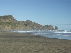
754:
699:
642:
622:
225:
556:
431:
1234:
A Field Guide to Auckland: Exploring the Region's Natural and Historical Heritage
574:
The percentage of people born overseas was 20.4, compared with 27.1% nationally.
1755:
1725:
1577:
1523:
828:
773:
571:, and 1.4% other ethnicities. People may identify with more than one ethnicity.
207:
289:(fortifications), walkways, canoe landings and sacred places. Te Henga and the
1835:
1562:
1091:(1990). "Prehistoric Sites in West Auckland". In Northcote-Bade, James (ed.).
630:
241:
1366:. Statistics New Zealand. March 2020. Muriwai Valley-Bethells Beach (115300).
65:
52:
1612:
1607:
1572:
257:
718:
664:
271:
1643:
1519:
1290:
327:
of Waiti described the wreck of the barque Helena, near the mouth of the
237:
1782:
742:
736:
494:
474:
473:
Muriwai Valley-Bethells Beach statistical area, which does not include
369:
245:
221:
1582:
1567:
1057:"Te Henga Park Reserve Management Plan: Description of Te Henga Park"
280:
1617:
1587:
1469:
833:
717:
663:
270:
240:
City, at the mouth of the Waitakere River where it flows into the
1145:
Taua, Te Warena (2009). "He Kohikohinga Kōrero mō Hikurangi". In
1592:
249:
1488:
621:, Te Henga / Bethells Beach and the surrounding area including
540:
Muriwai Valley-Bethells Beach had a population of 1,104 at the
228:
hull. This name originally applied to a wide area of the lower
602:
294:
244:. One of several popular resorts in the area (others include
1402:
489:
364:
1236:(Revised ed.). Random House New Zealand. p. 160.
236:
The beach is approximately 37 km (23 mi) west of
1380:
1324:. Statistics New Zealand. March 2020. 7002138 and 7002140.
676:
catchment consists of roughly 70 km of the bush-clad
970:
968:
465:
39 (17.3%) were part-time, and 9 (4.0%) were unemployed.
1369:
2018 Census place summary: Muriwai Valley-Bethells Beach
826:. Battle scenes for New Disney Channel Original movie
748:
Bush walking is encouraged, with boardwalks in place.
1095:. West Auckland Historical Society. pp. 34–36.
446:. People may identify with more than one ethnicity.
293:
have traditionally been major settled areas for the
1926:
1891:
1808:
1636:
1530:
1358:
1356:
840:'s first solo music video I, and the end scenes of
356:
Historical population for Bethells Beach settlement
185:
177:
172:
164:
159:
149:
144:
123:
113:
103:
91:
81:
23:
601:Te Henga is a tribal meeting ground for the local
548:, and an increase of 279 people (33.8%) since the
1223:
1221:
757:is also becoming quite popular with young people.
1204:. West Auckland Historical Society. p. 18.
1124:. West Auckland Historical Society. p. 27.
843:Crouching Tiger, Hidden Dragon: Sword of Destiny
617:7,000 years ago, when sea-levels rose after the
323:In excerpts from a letter of 23 September 1853,
1175:"Te Kawerau ā Maki Deed of Settlement Schedule"
423:, and an increase of 3 people (1.1%) since the
1316:
1314:
544:, an increase of 159 people (16.8%) since the
481:Historical population for the statistical area
469:Muriwai Valley-Bethells Beach statistical area
415:Bethells Beach had a population of 264 at the
1500:
8:
1364:"Statistical area 1 dataset for 2018 Census"
1322:"Statistical area 1 dataset for 2018 Census"
1114:
1112:
1035:
1033:
480:
355:
1051:
1049:
1047:
1045:
751:Sunbathing, swimming, picnics, running etc.
419:, an increase of 9 people (3.5%) since the
215:
1507:
1493:
1485:
1180:. New Zealand Government. 22 February 2014
479:
354:
20:
683:The major features of the catchment are:
660:Ecology of the Waitakere River catchment
1995:Populated places in the Auckland Region
934:
853:
171:
158:
143:
122:
80:
45:
41:
29:
1766:Te Rau-o-te-Huia / Mount Donald McLean
1470:Bethells Beach Surf Life Saving Patrol
1336:"Population estimate tables - NZ.Stat"
942:
940:
938:
1846:Te Uru Waitākere Contemporary Gallery
832:were also filmed there. In addition,
184:
176:
163:
148:
112:
102:
90:
7:
1741:Te Unuhanga-a-Rangitoto / Mercer Bay
1431:. Random House. pp. 13–14, 21.
637:derived from the volcanic rocks of
168:5.37 km (2.07 sq mi)
1793:Te Toka-Tapu-a-Kupe / Ninepin Rock
794:The New Adventures of Black Beauty
687:the abundance of native vegetation
150: • Territorial Authority
14:
1990:Waitākere Ranges Local Board Area
1516:Waitākere Ranges Local Board Area
1202:West Auckland Remembers, Volume 1
1122:West Auckland Remembers, Volume 1
1093:West Auckland Remembers, Volume 1
772:(1979). Other shoots include the
1917:Waitakere City Council (defunct)
1423:(2009). "Land, Sea and Sky". In
1287:New Zealand Sculpture: A History
916:
904:
892:
880:
868:
856:
823:Hercules: The Legendary Journeys
555:Ethnicities were 96.5% European/
430:Ethnicities were 96.6% European/
31:
1980:Beaches of the Auckland Region
1856:Waitākere Ranges Regional Park
1429:West: The History of Waitakere
1151:West: The History of Waitakere
589:and 1.9% had other religions.
461:and 3.4% had other religions.
18:Place in Auckland, New Zealand
1:
1904:Waitākere Ranges Local Board
1153:. Random House. p. 23.
802:, Brit/New Zealand TV movie
690:the steep and rugged terrain
202:, is a coastal community in
118:Waitākere Ranges Local Board
1816:Glen Eden Playhouse Theatre
1409:. Te Potiki National Trust.
1381:"Te Kāhui Māngai directory"
1257:Woodward, Mary (May 2021).
1066:. June 2002. Archived from
1009:(territorial authorities);
654:Waitākere Dam and Reservoir
2021:
2005:West Auckland, New Zealand
1949:Piha Surf Life Saving Club
1821:Goldie Bush Scenic Reserve
1809:Facilities and attractions
1232:; Murdoch, Graeme (2008).
629:tidal estuary. Over time,
1603:Te Henga / Bethells Beach
1295:Auckland University Press
1259:Waitakere's West Coasters
805:The Man Who Lost His Head
769:Children of Fire Mountain
533:
507:—
408:
382:—
260:, who was never located.
46:
42:
30:
25:Te Henga / Bethells Beach
1871:Upper Nihotupu Reservoir
1866:Lower Nihotupu Reservoir
1654:French Bay / Otitori Bay
948:"ArcGIS Web Application"
37:Sunset at Bethells Beach
1475:Photographs of Te Henga
1261:. Paradigm Associates.
952:statsnz.maps.arcgis.com
923:Surf lifesaving lookout
846:were also filmed here.
704:The Waitākere Reservoir
583:Māori religious beliefs
542:2018 New Zealand census
455:Māori religious beliefs
417:2018 New Zealand census
1861:Arataki Visitor Centre
1340:Statistics New Zealand
1064:Waitakere City Council
1016:Statistics New Zealand
998:Statistics New Zealand
980:Statistics New Zealand
811:Xena: Warrior Princess
782:Forever and for Always
723:
669:
276:
216:
189:52/km (140/sq mi)
66:36.89028°S 174.45139°E
1481:heritage collections.
1427:; Kerr, Ruth (eds.).
1149:; Kerr, Ruth (eds.).
991:(regional councils);
911:Burnt ablutions block
721:
667:
625:formed a part of the
341:100 Women Performance
274:
1954:Project Twin Streams
1289:(Updated ed.).
693:the Te Henga wetland
619:Last Glacial Maximum
186: • Density
71:-36.89028; 174.45139
1876:Waitākere Reservoir
1826:Hoani Waititi Marae
1637:Geographic features
1479:Auckland Libraries'
1455:. 23 December 2020.
649:and Lake Waiataru.
482:
357:
267:History and culture
233:(Bethells Beach)".
62: /
2000:Black sand beaches
1851:Waikumete Cemetery
1699:Little Muddy Creek
808:, and episodes of
724:
670:
277:
178: • Total
165: • Total
1967:
1966:
1425:Macdonald, Finlay
1304:978-1-86940-425-3
1268:978-0-473-57178-8
1147:Macdonald, Finlay
1089:Hayward, Bruce W.
863:Fun in the lagoon
607:Te Kawerau a Maki
538:
537:
413:
412:
298:Te Kawerau ā Maki
193:
192:
2012:
1985:Waitākere Ranges
1899:Auckland Council
1788:Paratutae Island
1751:Waitākere Ranges
1746:Waikumete Stream
1548:Henderson Valley
1531:Populated places
1509:
1502:
1495:
1486:
1457:
1456:
1449:
1443:
1442:
1417:
1411:
1410:
1399:
1393:
1392:
1377:
1371:
1367:
1360:
1351:
1350:
1348:
1346:
1332:
1326:
1325:
1318:
1309:
1308:
1279:
1273:
1272:
1254:
1248:
1247:
1243:978-1-86962-1513
1225:
1216:
1215:
1196:
1190:
1189:
1187:
1185:
1179:
1171:
1165:
1164:
1142:
1136:
1135:
1116:
1107:
1106:
1085:Diamond, John T.
1081:
1075:
1074:
1073:on 24 July 2011.
1072:
1061:
1053:
1040:
1037:
1028:
1026:
1024:
1022:
1008:
1006:
1004:
990:
988:
986:
972:
963:
962:
960:
958:
944:
920:
908:
896:
884:
875:Bethell patterns
872:
860:
786:Out of the Woods
762:Filming location
722:West coast shell
678:Waitākere Ranges
496:
491:
483:
371:
366:
358:
325:Henry Waterhouse
318:New Zealand flax
263:
219:
154:Auckland Council
77:
76:
74:
73:
72:
67:
63:
60:
59:
58:
55:
35:
21:
2020:
2019:
2015:
2014:
2013:
2011:
2010:
2009:
1970:
1969:
1968:
1963:
1934:Ark in the Park
1922:
1887:
1804:
1778:Waitākere River
1694:Kakamatua Inlet
1689:Big Muddy Creek
1684:Manukau Harbour
1632:
1526:
1513:
1466:
1461:
1460:
1451:
1450:
1446:
1439:
1419:
1418:
1414:
1401:
1400:
1396:
1379:
1378:
1374:
1362:
1361:
1354:
1344:
1342:
1334:
1333:
1329:
1320:
1319:
1312:
1305:
1297:. p. 123.
1281:
1280:
1276:
1269:
1256:
1255:
1251:
1244:
1228:Cameron, Ewen;
1227:
1226:
1219:
1212:
1198:
1197:
1193:
1183:
1181:
1177:
1173:
1172:
1168:
1161:
1144:
1143:
1139:
1132:
1118:
1117:
1110:
1103:
1083:
1082:
1078:
1070:
1059:
1055:
1054:
1043:
1038:
1031:
1020:
1018:
1010:
1002:
1000:
992:
984:
982:
974:
973:
966:
956:
954:
946:
945:
936:
931:
924:
921:
912:
909:
900:
897:
888:
885:
876:
873:
864:
861:
852:
764:
733:
674:Waitākere River
662:
635:titanomagnetite
627:Waitākere River
615:
599:
565:Pacific peoples
471:
440:Pacific peoples
349:
329:Waitakere River
320:was harvested.
302:Waitākere River
291:Waitākere River
269:
261:
230:Waitakere River
224:of an upturned
140:
136:Tāmaki Makaurau
70:
68:
64:
61:
56:
53:
51:
49:
48:
38:
26:
19:
12:
11:
5:
2018:
2016:
2008:
2007:
2002:
1997:
1992:
1987:
1982:
1972:
1971:
1965:
1964:
1962:
1961:
1956:
1951:
1946:
1941:
1936:
1930:
1928:
1924:
1923:
1921:
1920:
1913:
1912:
1911:
1909:Waitākere Ward
1906:
1895:
1893:
1889:
1888:
1886:
1885:
1884:
1883:
1878:
1873:
1868:
1863:
1853:
1848:
1843:
1838:
1833:
1828:
1823:
1818:
1812:
1810:
1806:
1805:
1803:
1802:
1797:
1796:
1795:
1790:
1780:
1775:
1774:
1773:
1771:Te Toiokawharu
1768:
1763:
1758:
1748:
1743:
1738:
1736:Taitomo Island
1733:
1731:Swanson Stream
1728:
1723:
1718:
1716:Opanuku Stream
1713:
1708:
1703:
1702:
1701:
1696:
1691:
1681:
1676:
1671:
1669:Lake Kawaupaka
1666:
1664:Kitekite Falls
1661:
1659:Karekare Falls
1656:
1651:
1646:
1640:
1638:
1634:
1633:
1631:
1630:
1628:Woodlands Park
1625:
1620:
1615:
1610:
1605:
1600:
1595:
1590:
1585:
1580:
1575:
1570:
1565:
1560:
1555:
1550:
1545:
1540:
1534:
1532:
1528:
1527:
1514:
1512:
1511:
1504:
1497:
1489:
1483:
1482:
1472:
1465:
1464:External links
1462:
1459:
1458:
1444:
1437:
1421:Hayward, Bruce
1412:
1394:
1389:Te Puni Kōkiri
1372:
1352:
1327:
1310:
1303:
1274:
1267:
1249:
1242:
1230:Hayward, Bruce
1217:
1210:
1191:
1166:
1159:
1137:
1130:
1108:
1101:
1076:
1041:
1029:
964:
933:
932:
930:
927:
926:
925:
922:
915:
913:
910:
903:
901:
898:
891:
889:
886:
879:
877:
874:
867:
865:
862:
855:
851:
848:
817:Young Hercules
763:
760:
759:
758:
752:
749:
746:
740:
732:
729:
706:
705:
702:
697:
696:the sand dunes
694:
691:
688:
661:
658:
647:Lake Kawaupaku
614:
611:
598:
595:
536:
535:
531:
530:
527:
524:
520:
519:
516:
513:
509:
508:
505:
502:
498:
497:
492:
487:
470:
467:
411:
410:
406:
405:
402:
399:
395:
394:
391:
388:
384:
383:
380:
377:
373:
372:
367:
362:
348:
345:
275:Bethells Beach
268:
265:
200:Bethells Beach
191:
190:
187:
183:
182:
179:
175:
174:
170:
169:
166:
162:
161:
157:
156:
151:
147:
146:
142:
141:
139:
138:
133:
127:
125:
121:
120:
115:
111:
110:
108:Waitākere ward
105:
101:
100:
95:
89:
88:
85:
79:
78:
44:
43:
40:
39:
36:
28:
27:
24:
17:
13:
10:
9:
6:
4:
3:
2:
2017:
2006:
2003:
2001:
1998:
1996:
1993:
1991:
1988:
1986:
1983:
1981:
1978:
1977:
1975:
1960:
1957:
1955:
1952:
1950:
1947:
1945:
1944:Oratia United
1942:
1940:
1939:Glenora Bears
1937:
1935:
1932:
1931:
1929:
1927:Organisations
1925:
1919:
1918:
1914:
1910:
1907:
1905:
1902:
1901:
1900:
1897:
1896:
1894:
1890:
1882:
1881:Whatipu Lodge
1879:
1877:
1874:
1872:
1869:
1867:
1864:
1862:
1859:
1858:
1857:
1854:
1852:
1849:
1847:
1844:
1842:
1839:
1837:
1834:
1832:
1831:Lopdell House
1829:
1827:
1824:
1822:
1819:
1817:
1814:
1813:
1811:
1807:
1801:
1798:
1794:
1791:
1789:
1786:
1785:
1784:
1781:
1779:
1776:
1772:
1769:
1767:
1764:
1762:
1759:
1757:
1754:
1753:
1752:
1749:
1747:
1744:
1742:
1739:
1737:
1734:
1732:
1729:
1727:
1724:
1722:
1721:Oratia Stream
1719:
1717:
1714:
1712:
1709:
1707:
1706:Mokoroa Falls
1704:
1700:
1697:
1695:
1692:
1690:
1687:
1686:
1685:
1682:
1680:
1677:
1675:
1672:
1670:
1667:
1665:
1662:
1660:
1657:
1655:
1652:
1650:
1647:
1645:
1642:
1641:
1639:
1635:
1629:
1626:
1624:
1621:
1619:
1616:
1614:
1611:
1609:
1606:
1604:
1601:
1599:
1596:
1594:
1591:
1589:
1586:
1584:
1581:
1579:
1576:
1574:
1571:
1569:
1566:
1564:
1561:
1559:
1556:
1554:
1551:
1549:
1546:
1544:
1541:
1539:
1536:
1535:
1533:
1529:
1525:
1521:
1517:
1510:
1505:
1503:
1498:
1496:
1491:
1490:
1487:
1480:
1476:
1473:
1471:
1468:
1467:
1463:
1454:
1448:
1445:
1440:
1438:9781869790080
1434:
1430:
1426:
1422:
1416:
1413:
1408:
1407:maorimaps.com
1404:
1398:
1395:
1390:
1386:
1382:
1376:
1373:
1370:
1365:
1359:
1357:
1353:
1341:
1337:
1331:
1328:
1323:
1317:
1315:
1311:
1306:
1300:
1296:
1292:
1288:
1284:
1283:Dunn, Michael
1278:
1275:
1270:
1264:
1260:
1253:
1250:
1245:
1239:
1235:
1231:
1224:
1222:
1218:
1213:
1211:0-473-00983-8
1207:
1203:
1195:
1192:
1176:
1170:
1167:
1162:
1160:9781869790080
1156:
1152:
1148:
1141:
1138:
1133:
1131:0-473-00983-8
1127:
1123:
1115:
1113:
1109:
1104:
1102:0-473-00983-8
1098:
1094:
1090:
1086:
1080:
1077:
1069:
1065:
1058:
1052:
1050:
1048:
1046:
1042:
1036:
1034:
1030:
1027:(urban areas)
1017:
1013:
999:
995:
981:
977:
971:
969:
965:
953:
949:
943:
941:
939:
935:
928:
919:
914:
907:
902:
895:
890:
883:
878:
871:
866:
859:
854:
849:
847:
845:
844:
839:
835:
831:
830:
825:
824:
819:
818:
813:
812:
807:
806:
801:
800:
795:
791:
787:
783:
779:
775:
771:
770:
761:
756:
753:
750:
747:
744:
741:
738:
735:
734:
730:
728:
720:
716:
713:
709:
703:
701:
698:
695:
692:
689:
686:
685:
684:
681:
679:
675:
668:Cabbage trees
666:
659:
657:
655:
650:
648:
644:
640:
636:
632:
628:
624:
620:
612:
610:
608:
604:
596:
594:
590:
588:
584:
580:
575:
572:
570:
566:
562:
558:
553:
551:
547:
543:
532:
528:
525:
522:
521:
517:
514:
511:
510:
506:
503:
500:
499:
493:
488:
485:
484:
478:
476:
468:
466:
462:
460:
456:
452:
447:
445:
441:
437:
433:
428:
426:
422:
418:
407:
403:
400:
397:
396:
392:
389:
386:
385:
381:
378:
375:
374:
368:
363:
360:
359:
353:
346:
344:
342:
337:
333:
330:
326:
321:
319:
313:
311:
310:West Auckland
307:
303:
299:
296:
292:
288:
287:
282:
273:
266:
264:
259:
255:
251:
247:
243:
239:
234:
231:
227:
223:
218:
213:
209:
205:
204:West Auckland
201:
197:
188:
180:
167:
155:
152:
137:
134:
132:
129:
128:
126:
119:
116:
109:
106:
99:
96:
94:
86:
84:
75:
47:Coordinates:
34:
22:
16:
1915:
1841:Scenic Drive
1800:Whites Beach
1761:Ruaotuwhenua
1674:Lake Wainamu
1602:
1447:
1428:
1415:
1406:
1403:"Māori Maps"
1397:
1384:
1375:
1343:. Retrieved
1330:
1286:
1277:
1258:
1252:
1233:
1201:
1194:
1182:. Retrieved
1169:
1150:
1140:
1121:
1092:
1079:
1068:the original
1019:. Retrieved
1001:. Retrieved
983:. Retrieved
955:. Retrieved
951:
841:
827:
821:
815:
809:
803:
797:
793:
792:, TV series
790:Taylor Swift
778:Shania Twain
767:
765:
755:Skimboarding
725:
714:
710:
707:
700:Lake Wainamu
682:
671:
651:
643:Lake Wainamu
623:Lake Wainamu
616:
600:
591:
585:, 0.5% were
576:
573:
554:
539:
472:
463:
457:, 2.3% were
448:
429:
414:
350:
347:Demographics
340:
338:
334:
322:
314:
312:in general.
284:
278:
235:
199:
195:
194:
15:
1959:Studio West
1756:Pukematekeo
1726:Piha Stream
1711:O'Neill Bay
1649:Fairy Falls
1578:Little Huia
1524:New Zealand
1385:tkm.govt.nz
829:Avalon High
780:'s single "
774:music video
581:, 0.5% had
550:2006 census
546:2013 census
453:, 1.1% had
442:, and 3.4%
425:2006 census
421:2013 census
208:New Zealand
124:Electorates
114:Local board
87:New Zealand
69: /
57:174°27′05″E
1974:Categories
1892:Government
1836:Parrs Park
1563:Kaurilands
1538:Cornwallis
1345:25 October
1184:29 January
1021:25 October
1003:25 October
985:25 October
929:References
784:"(2003), "
631:Tasman Sea
242:Tasman Sea
173:Population
145:Government
54:36°53′25″S
1679:Lion Rock
1623:Waitākere
1613:Waiatarua
1608:Titirangi
1573:Laingholm
1543:Glen Eden
799:The Wilds
579:Christian
451:Christian
258:Sonny Fai
1644:Anawhata
1558:Karekare
1520:Auckland
1477:held in
1291:Auckland
1285:(2008).
731:Activity
639:Taranaki
587:Buddhist
559:, 10.1%
534:Source:
459:Buddhist
434:, 10.2%
409:Source:
254:Karekare
238:Auckland
196:Te Henga
131:New Lynn
98:Auckland
1783:Whatipu
1598:Swanson
850:Gallery
838:Taeyeon
836:singer
743:Fishing
737:Surfing
613:Geology
567:, 1.6%
563:, 3.0%
495:±% p.a.
475:Muriwai
438:, 4.5%
370:±% p.a.
246:Muriwai
222:gunwale
83:Country
1583:Oratia
1568:Konini
1435:
1301:
1265:
1240:
1208:
1157:
1128:
1099:
957:6 June
820:, and
788:" for
557:Pākehā
529:+3.16%
518:+1.96%
432:Pākehā
404:+0.70%
393:−0.33%
352:area.
308:, and
306:Ranges
281:midden
210:. The
93:Region
1618:Waima
1588:Parau
1178:(PDF)
1071:(PDF)
1060:(PDF)
834:K-pop
597:Marae
569:Asian
561:Māori
526:1,104
444:Asian
436:Māori
217:Henga
212:Māori
198:, or
1593:Piha
1553:Huia
1433:ISBN
1347:2023
1299:ISBN
1263:ISBN
1238:ISBN
1206:ISBN
1186:2021
1155:ISBN
1126:ISBN
1097:ISBN
1023:2023
1005:2023
987:2023
959:2022
899:Shag
887:Cave
796:and
776:for
672:The
523:2018
512:2013
501:2006
490:Pop.
486:Year
398:2018
387:2013
376:2006
365:Pop.
361:Year
252:and
250:Piha
226:waka
160:Area
104:Ward
605:of
603:iwi
515:945
504:825
401:264
390:255
379:261
295:iwi
220:or
181:280
1976::
1522:,
1518:,
1405:.
1387:.
1383:.
1355:^
1338:.
1313:^
1293::
1220:^
1111:^
1087:;
1062:.
1044:^
1032:^
1014:.
996:.
978:.
967:^
950:.
937:^
814:,
645:,
343:.
304:,
286:pā
248:,
206:,
1508:e
1501:t
1494:v
1441:.
1391:.
1349:.
1307:.
1271:.
1246:.
1214:.
1188:.
1163:.
1134:.
1105:.
1025:.
1007:.
989:.
961:.
Text is available under the Creative Commons Attribution-ShareAlike License. Additional terms may apply.