33:
32:
348:. There were 75 households, comprising 120 males and 105 females, giving a sex ratio of 1.14 males per female. The median age was 30.5 years (compared with 37.4 years nationally), with 57 people (25.3%) aged under 15 years, 54 (24.0%) aged 15 to 29, 75 (33.3%) aged 30 to 64, and 36 (16.0%) aged 65 or older.
361:
Of those at least 15 years old, 9 (5.4%) people had a bachelor or higher degree, and 36 (21.4%) people had no formal qualifications. The median income was $ 20,000, compared with $ 31,800 nationally. 6 people (3.6%) earned over $ 70,000 compared to 17.2% nationally. The employment status of those at
41:
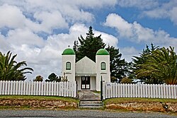
Church at Te Kao is characterised by bell towers at each of the front corners, which bear the words "Arepa" and "Omeka" (Maori transliterations of the Greek words Alpha and Omega – the beginning and the
400:
The school started as Te Kao Native School in 1881. It became Te Kao Area School, providing education up to seventh form, but with few secondary students it changed to become a primary school in 1999.
702:
403:
The school celebrated its 125th anniversary during Labour
Weekend in 2006. It became a designated character school at the start of 2019, and extended to include years 9 and 10 in 2020.
1987:
763:
504:
354:
Of those people who chose to answer the census's question about religious affiliation, 20.0% had no religion, 45.3% were
Christian and 29.3% had
558:
55:
1668:
351:
Ethnicities were 22.7% European/Pākehā, 92.0% Māori, 9.3% Pacific peoples, and 1.3% Asian. People may identify with more than one ethnicity.
1522:
205:(tribe with traditional authority over a territory) over Te Kao and the surrounding district, and it is the principal settlement of the
1517:
145:
1421:
469:
444:
237:
209:(tribe). Te Aupōuri's Post-Settlement Governance Entity, Te Runanga Nui o Te Aupōuri, has an office at Te Kao, along with the iwi's
519:
265:
Te Kao is in an SA1 statistical area which covers 69.50 km (26.83 sq mi) and includes the area between the mouth of
756:
1658:
1768:
870:
230:
1936:
1718:
612:
1982:
1773:
749:
362:
least 15 was that 66 (39.3%) people were employed full-time, 18 (10.7%) were part-time, and 9 (5.4%) were unemployed.
218:
670:
1920:
1894:
1884:
1843:
1833:
1442:
637:
499:
178:
168:
397:
Te Kura o Te Kao is a coeducational full primary (years 1–8) school with a roll of 70 students as of August 2024.
1868:
1793:
1552:
1542:
1447:
688:
485:
1698:
1557:
1547:
345:
341:
337:
1788:
1783:
1693:
1228:
658:
623:
386:
543:
1778:
1653:
1243:
1111:
1051:
1041:
905:
785:
731:
1723:
1713:
1648:
1643:
1370:
1338:
1136:
1126:
1016:
931:
895:
845:
266:
1813:
1688:
1293:
1196:
1021:
1961:
1941:
1889:
1733:
1683:
1426:
1416:
855:
772:
108:
1502:
1803:
1748:
1738:
1708:
1703:
1678:
1201:
1176:
1171:
1151:
1146:
1116:
1008:
830:
580:
465:
440:
355:
270:
190:
1863:
1838:
1808:
1743:
1728:
1622:
1617:
1457:
1411:
1303:
994:
926:
900:
194:
98:
1537:
1527:
1482:
1406:
984:
1915:
1853:
1823:
1663:
1612:
1602:
1597:
1577:
1507:
1492:
1263:
1004:
920:
880:
150:
1976:
1956:
1946:
1818:
1627:
1607:
1592:
1582:
1532:
1487:
1385:
1380:
1375:
1365:
1333:
1121:
974:
964:
936:
820:
371:
254:
198:
1283:
1858:
1673:
1587:
1572:
1567:
1477:
1462:
1401:
979:
860:
1161:
1141:
741:
1951:
1848:
1828:
1562:
1472:
1467:
1268:
1056:
989:
954:
941:
776:
222:
202:
717:
1910:
1512:
1497:
1273:
1253:
370:
Pōtahi Marae, near the centre of Te Kao, is the traditional meeting place for
70:
57:
1452:
1308:
1248:
1206:
1156:
969:
885:
840:
241:
38:
1328:
1258:
1220:
1166:
1106:
1101:
1081:
1061:
1046:
915:
890:
825:
214:
1798:
1323:
1318:
1298:
1288:
1278:
1238:
1216:
1191:
1186:
1131:
1071:
1066:
949:
910:
875:
865:
850:
835:
810:
789:
290:
226:
1313:
1233:
1096:
1091:
1076:
1036:
1031:
815:
718:"Designation of Te Kao School (1) as a Designated Character School"
671:"Te Aupouri and the Crown: Deed of Settlement of Historical Claims"
1181:
210:
1086:
1026:
745:
488:. New Zealand Ministry for Culture and Heritage. 6 August 2019.
257:, started his legendary run along Ninety Mile Beach at Te Kao.
206:
385:
In
October 2020, the Government committed $ 220,442 from the
594:
285:
572:
336:
The SA1 statistical area had a population of 225 at the
269:
and
Tauwhia Stream. The SA1 area is part of the larger
422:
The
Visitors' Guide to the Far North - Mangonui County
1929:
1903:
1877:
1761:
1636:
1435:
1394:
1358:
1351:
1215:
1003:
803:
796:
229:is 24 km to the south. The Aupouri Forest and
174:
164:
159:
138:
130:
122:
114:
104:
94:
86:
23:
344:, and an increase of 9 people (4.2%) since the
561:. Statistics New Zealand. March 2020. 7000003.
757:
689:"Te Kao Area School to Become Primary School"
553:
551:
340:, an increase of 54 people (31.6%) since the
8:
559:"Statistical area 1 dataset for 2018 Census"
374:, and includes the wharehui (meeting house)
276:
245:
1355:
800:
764:
750:
742:
275:
20:
1988:Populated places in the Northland Region
734:. Education Review Office. 9 July 2019.
505:Te Ara: The Encyclopedia of New Zealand
412:
389:to upgrade the marae, creating 9 jobs.
158:
137:
85:
50:
46:
29:
18:Place in Northland Region, New Zealand
1669:Kaikohe-Bay of Islands volcanic field
544:2018 Census place summary: North Cape
173:
163:
129:
121:
113:
103:
93:
7:
640:. New Zealand Ministry of Education
462:The Geographic Atlas of New Zealand
716:Casey, Katrina (5 February 2018).
659:Education Counts: Te Kura o Te Kao
464:. Robbie Burton. pp. map 15.
240:gives a translation of "the dried
165: • Territorial Authority
14:
238:Ministry for Culture and Heritage
687:Creech, Wyatt (8 October 1998).
225:is 46 km to the north, and
31:
1659:Cape Reinga / Te Rerenga Wairua
732:"Te Kura o Te Kao - 09/07/2019"
638:"New Zealand Schools Directory"
500:"Muriwhenua Tribes - Ancestors"
460:Roger Smith, GeographX (2005).
1769:Bay of Islands Vintage Railway
676:. 28 January 2012. p. 27.
439:. Reed Books. pp. map 2.
1:
221:passes through the district.
175: • Regional council
1719:Rainbow Falls / Waianiwaniwa
253:The athlete Te Houtaewa, of
1774:Butler Point Whaling Museum
601:. Te Potiki National Trust.
573:"Te Kāhui Māngai directory"
435:Peter Dowling, ed. (2004).
424:(3rd ed.). p. 44.
378:and wharekai (dining hall)
271:North Cape statistical area
2004:
1834:RNZAF Station Waipapakauri
1762:Facilities and attractions
1422:Motukokako / Piercy Island
179:Northland Regional Council
169:Far North District Council
783:
720:. New Zealand Government.
691:. New Zealand Parliament.
420:Parkes, W. F. (c. 1965).
329:
303:—
51:
47:
30:
1869:Waitangi Treaty Monument
520:"ArcGIS Web Application"
486:"1000 Māori place names"
1699:Ngawha geothermal field
524:statsnz.maps.arcgis.com
356:Māori religious beliefs
338:2018 New Zealand census
1824:Okaihau Railway Branch
1789:Christ Church, Russell
1784:Cape Reinga Lighthouse
624:Provincial Growth Fund
437:Reed New Zealand Atlas
387:Provincial Growth Fund
246:
71:34.65139°S 172.97028°E
1779:Cape Brett Lighthouse
1654:Cape Maria van Diemen
906:Piwhane / Spirits Bay
613:"Marae Announcements"
277:Historical population
1724:Runaruna Mud Volcano
1714:Parengarenga Harbour
1649:Cape Brett Peninsula
1523:Rotokawau (Karikari)
1017:Cape Brett Peninsula
896:Parengarenga Harbour
267:Parengarenga Harbour
189:is a village on the
76:-34.65139; 172.97028
1829:Opua Railway Branch
1689:Maungataniwha Range
1518:Rotokawau (Aupōuri)
1352:Geographic features
620:growregions.govt.nz
278:
67: /
1983:Far North District
1962:Te Waimate mission
1942:Battle of Ohaeawai
1734:Te Paki Sand Dunes
1684:Karikari Peninsula
1427:Urupukapuka Island
1417:Motukawanui Island
856:Karikari Peninsula
773:Far North District
380:Te Rongopātūtaonga
109:Far North District
1970:
1969:
1921:Northland College
1804:Kaikohe Aerodrome
1757:
1756:
1749:Whangaroa Harbour
1709:Purerua Peninsula
1679:Kaimaumau wetland
1644:Aupōuri Peninsula
1347:
1346:
871:Ninety Mile Beach
626:. 9 October 2020.
334:
333:
233:are to the west.
231:Ninety Mile Beach
191:Aupouri Peninsula
184:
183:
1995:
1895:Regional Council
1885:District Council
1864:Wairere Boulders
1844:St. James Church
1839:Pompallier House
1814:Māngungu Mission
1809:Kerikeri Airport
1744:Whangape Harbour
1458:Half Mile Lagoon
1412:Simmonds Islands
1371:Great Exhibition
1356:
801:
797:Populated places
766:
759:
752:
743:
736:
735:
728:
722:
721:
713:
707:
706:
703:"School Reunion"
699:
693:
692:
684:
678:
677:
675:
667:
661:
656:
650:
649:
647:
645:
634:
628:
627:
617:
609:
603:
602:
591:
585:
584:
569:
563:
562:
555:
546:
541:
535:
534:
532:
530:
516:
510:
509:
496:
490:
489:
482:
476:
475:
457:
451:
450:
432:
426:
425:
417:
292:
287:
279:
249:
236:The New Zealand
99:Northland Region
82:
81:
79:
78:
77:
72:
68:
65:
64:
63:
60:
35:
21:
2003:
2002:
1998:
1997:
1996:
1994:
1993:
1992:
1973:
1972:
1971:
1966:
1957:Opo the dolphin
1925:
1899:
1873:
1753:
1632:
1431:
1407:Cavalli Islands
1390:
1343:
1211:
999:
985:Waitiki Landing
946:
792:
779:
770:
740:
739:
730:
729:
725:
715:
714:
710:
705:. maori.org.nz.
701:
700:
696:
686:
685:
681:
673:
669:
668:
664:
657:
653:
643:
641:
636:
635:
631:
615:
611:
610:
606:
593:
592:
588:
571:
570:
566:
557:
556:
549:
542:
538:
528:
526:
518:
517:
513:
498:
497:
493:
484:
483:
479:
472:
459:
458:
454:
447:
434:
433:
429:
419:
418:
414:
409:
395:
368:
263:
219:State Highway 1
197:, New Zealand.
155:
75:
73:
69:
66:
61:
58:
56:
54:
53:
43:
26:
19:
12:
11:
5:
2001:
1999:
1991:
1990:
1985:
1975:
1974:
1968:
1967:
1965:
1964:
1959:
1954:
1949:
1944:
1939:
1937:Arthur's Stone
1933:
1931:
1927:
1926:
1924:
1923:
1918:
1913:
1907:
1905:
1901:
1900:
1898:
1897:
1892:
1887:
1881:
1879:
1875:
1874:
1872:
1871:
1866:
1861:
1856:
1851:
1846:
1841:
1836:
1831:
1826:
1821:
1816:
1811:
1806:
1801:
1796:
1791:
1786:
1781:
1776:
1771:
1765:
1763:
1759:
1758:
1755:
1754:
1752:
1751:
1746:
1741:
1736:
1731:
1726:
1721:
1716:
1711:
1706:
1701:
1696:
1691:
1686:
1681:
1676:
1671:
1666:
1664:Horeke basalts
1661:
1656:
1651:
1646:
1640:
1638:
1634:
1633:
1631:
1630:
1625:
1620:
1615:
1610:
1605:
1600:
1595:
1590:
1585:
1580:
1575:
1570:
1565:
1560:
1555:
1550:
1545:
1540:
1535:
1530:
1525:
1520:
1515:
1510:
1505:
1500:
1495:
1490:
1485:
1480:
1475:
1470:
1465:
1460:
1455:
1450:
1445:
1439:
1437:
1433:
1432:
1430:
1429:
1424:
1419:
1414:
1409:
1404:
1398:
1396:
1392:
1391:
1389:
1388:
1383:
1378:
1373:
1368:
1362:
1360:
1353:
1349:
1348:
1345:
1344:
1342:
1341:
1336:
1331:
1326:
1321:
1316:
1311:
1306:
1301:
1296:
1291:
1286:
1281:
1276:
1271:
1266:
1264:Ngawha Springs
1261:
1256:
1251:
1246:
1241:
1236:
1231:
1225:
1223:
1213:
1212:
1210:
1209:
1204:
1199:
1194:
1189:
1184:
1179:
1174:
1169:
1164:
1159:
1154:
1149:
1144:
1139:
1134:
1129:
1124:
1119:
1114:
1109:
1104:
1099:
1094:
1089:
1084:
1079:
1074:
1069:
1064:
1059:
1054:
1052:Kerikeri Inlet
1049:
1044:
1039:
1034:
1029:
1024:
1019:
1013:
1011:
1005:Bay of Islands
1001:
1000:
998:
997:
992:
987:
982:
977:
972:
967:
962:
957:
952:
947:
945:
944:
939:
934:
929:
923:
921:Taipa-Mangonui
918:
913:
908:
903:
898:
893:
888:
883:
881:Oruru-Parapara
878:
873:
868:
863:
858:
853:
848:
843:
838:
833:
828:
823:
818:
813:
807:
805:
798:
794:
793:
784:
781:
780:
771:
769:
768:
761:
754:
746:
738:
737:
723:
708:
694:
679:
662:
651:
629:
604:
586:
581:Te Puni Kōkiri
564:
547:
536:
511:
491:
477:
470:
452:
445:
427:
411:
410:
408:
405:
394:
391:
367:
364:
332:
331:
327:
326:
323:
320:
316:
315:
312:
309:
305:
304:
301:
298:
294:
293:
288:
283:
262:
259:
182:
181:
176:
172:
171:
166:
162:
161:
157:
156:
154:
153:
151:Te Tai Tokerau
148:
142:
140:
136:
135:
132:
128:
127:
124:
120:
119:
116:
112:
111:
106:
102:
101:
96:
92:
91:
88:
84:
83:
49:
48:
45:
44:
36:
28:
27:
24:
17:
13:
10:
9:
6:
4:
3:
2:
2000:
1989:
1986:
1984:
1981:
1980:
1978:
1963:
1960:
1958:
1955:
1953:
1950:
1948:
1947:Boyd massacre
1945:
1943:
1940:
1938:
1935:
1934:
1932:
1928:
1922:
1919:
1917:
1914:
1912:
1909:
1908:
1906:
1904:Organisations
1902:
1896:
1893:
1891:
1888:
1886:
1883:
1882:
1880:
1876:
1870:
1867:
1865:
1862:
1860:
1857:
1855:
1852:
1850:
1847:
1845:
1842:
1840:
1837:
1835:
1832:
1830:
1827:
1825:
1822:
1820:
1819:Mission House
1817:
1815:
1812:
1810:
1807:
1805:
1802:
1800:
1797:
1795:
1792:
1790:
1787:
1785:
1782:
1780:
1777:
1775:
1772:
1770:
1767:
1766:
1764:
1760:
1750:
1747:
1745:
1742:
1740:
1737:
1735:
1732:
1730:
1727:
1725:
1722:
1720:
1717:
1715:
1712:
1710:
1707:
1705:
1702:
1700:
1697:
1695:
1692:
1690:
1687:
1685:
1682:
1680:
1677:
1675:
1672:
1670:
1667:
1665:
1662:
1660:
1657:
1655:
1652:
1650:
1647:
1645:
1642:
1641:
1639:
1635:
1629:
1626:
1624:
1621:
1619:
1616:
1614:
1611:
1609:
1606:
1604:
1601:
1599:
1596:
1594:
1591:
1589:
1586:
1584:
1581:
1579:
1576:
1574:
1571:
1569:
1566:
1564:
1561:
1559:
1556:
1554:
1551:
1549:
1546:
1544:
1541:
1539:
1536:
1534:
1531:
1529:
1526:
1524:
1521:
1519:
1516:
1514:
1511:
1509:
1506:
1504:
1501:
1499:
1496:
1494:
1491:
1489:
1486:
1484:
1481:
1479:
1476:
1474:
1471:
1469:
1466:
1464:
1461:
1459:
1456:
1454:
1451:
1449:
1446:
1444:
1441:
1440:
1438:
1434:
1428:
1425:
1423:
1420:
1418:
1415:
1413:
1410:
1408:
1405:
1403:
1400:
1399:
1397:
1393:
1387:
1384:
1382:
1379:
1377:
1374:
1372:
1369:
1367:
1364:
1363:
1361:
1357:
1354:
1350:
1340:
1337:
1335:
1334:Waimate North
1332:
1330:
1327:
1325:
1322:
1320:
1317:
1315:
1312:
1310:
1307:
1305:
1302:
1300:
1297:
1295:
1292:
1290:
1287:
1285:
1282:
1280:
1277:
1275:
1272:
1270:
1267:
1265:
1262:
1260:
1257:
1255:
1252:
1250:
1247:
1245:
1242:
1240:
1237:
1235:
1232:
1230:
1227:
1226:
1224:
1222:
1218:
1214:
1208:
1205:
1203:
1200:
1198:
1195:
1193:
1190:
1188:
1185:
1183:
1180:
1178:
1175:
1173:
1170:
1168:
1165:
1163:
1160:
1158:
1155:
1153:
1150:
1148:
1145:
1143:
1140:
1138:
1135:
1133:
1130:
1128:
1125:
1123:
1122:Rangihoua Bay
1120:
1118:
1115:
1113:
1110:
1108:
1105:
1103:
1100:
1098:
1095:
1093:
1090:
1088:
1085:
1083:
1080:
1078:
1075:
1073:
1070:
1068:
1065:
1063:
1060:
1058:
1055:
1053:
1050:
1048:
1045:
1043:
1040:
1038:
1035:
1033:
1030:
1028:
1025:
1023:
1020:
1018:
1015:
1014:
1012:
1010:
1006:
1002:
996:
993:
991:
988:
986:
983:
981:
978:
976:
975:Waimahana Bay
973:
971:
968:
966:
965:Tokerau Beach
963:
961:
958:
956:
953:
951:
948:
943:
940:
938:
937:Coopers Beach
935:
933:
930:
928:
925:
924:
922:
919:
917:
914:
912:
909:
907:
904:
902:
899:
897:
894:
892:
889:
887:
884:
882:
879:
877:
874:
872:
869:
867:
864:
862:
859:
857:
854:
852:
849:
847:
844:
842:
839:
837:
834:
832:
829:
827:
824:
822:
821:Henderson Bay
819:
817:
814:
812:
809:
808:
806:
802:
799:
795:
791:
787:
782:
778:
774:
767:
762:
760:
755:
753:
748:
747:
744:
733:
727:
724:
719:
712:
709:
704:
698:
695:
690:
683:
680:
672:
666:
663:
660:
655:
652:
639:
633:
630:
625:
621:
614:
608:
605:
600:
599:maorimaps.com
596:
590:
587:
582:
578:
574:
568:
565:
560:
554:
552:
548:
545:
540:
537:
525:
521:
515:
512:
507:
506:
501:
495:
492:
487:
481:
478:
473:
471:1-877333-20-4
467:
463:
456:
453:
448:
446:0-7900-0952-8
442:
438:
431:
428:
423:
416:
413:
406:
404:
401:
398:
392:
390:
388:
383:
381:
377:
373:
365:
363:
359:
357:
352:
349:
347:
343:
339:
328:
324:
321:
318:
317:
313:
310:
307:
306:
302:
299:
296:
295:
289:
284:
281:
280:
274:
272:
268:
260:
258:
256:
251:
248:
243:
239:
234:
232:
228:
224:
220:
216:
212:
208:
204:
200:
196:
192:
188:
180:
177:
170:
167:
152:
149:
147:
144:
143:
141:
133:
125:
117:
110:
107:
100:
97:
89:
80:
52:Coordinates:
40:
34:
22:
16:
1859:Treaty House
1694:Maungaturoto
1674:Kaikohe Hill
1503:Lake Ōmāpere
1448:Bulrush Lake
1402:Aroha Island
1177:Totara North
980:Waipapakauri
959:
861:Lake Manuwai
726:
711:
697:
682:
665:
654:
644:17 September
642:. Retrieved
632:
619:
607:
598:
595:"Māori Maps"
589:
576:
567:
539:
527:. Retrieved
523:
514:
503:
494:
480:
461:
455:
436:
430:
421:
415:
402:
399:
396:
384:
379:
376:Waimirirangi
375:
369:
360:
353:
350:
335:
264:
261:Demographics
252:
235:
186:
185:
15:
1952:Dog Tax War
1916:Ngāi Takoto
1854:Tāne Mahuta
1849:Stone Store
1794:Eagles Nest
1618:Waiporohita
1152:Taronui Bay
1057:Matauri Bay
990:Whatuwhiwhi
777:New Zealand
577:tkm.govt.nz
346:2006 census
342:2013 census
223:Cape Reinga
203:mana whenua
139:Electorates
131:Subdivision
90:New Zealand
74: /
62:172°58′13″E
1977:Categories
1911:Muriwhenua
1878:Government
1704:North Cape
1538:Rotopokaka
1528:Rotokereru
1483:Morehurehu
1254:Matihetihe
1112:Puketotara
372:Te Aupōuri
255:Te Aupōuri
199:Te Aupōuri
160:Government
134:North Cape
59:34°39′05″S
1637:Landforms
1623:Waitahora
1613:Waiparera
1603:Waimimiha
1598:Waikaramu
1578:Te Kahika
1508:Owhareiti
1493:Ngakeketa
1386:Waimahana
1381:Rangihoua
1376:Henderson
1366:Doubtless
1339:Whirinaki
1309:Rangiahua
1304:Pawarenga
1249:Mangamuka
1229:Broadwood
1207:Whangaroa
1202:Waitaruke
1162:Taupō Bay
1157:Taumarere
1142:Tākou Bay
1127:Rangitane
1009:Whangaroa
970:Waiharara
932:Cable Bay
886:Pamapuria
846:Kaingaroa
841:Kaimaumau
393:Education
195:Northland
146:Northland
123:Community
1628:Whirirau
1608:Waingaro
1593:Waikanae
1583:Wahakari
1533:Rotomata
1488:Ngakapua
1269:Ōhaeawai
1259:Mitimiti
1244:Kohukohu
1221:Hokianga
1197:Waitangi
1167:Te Haumi
1107:Puketona
1102:Pakaraka
1082:Oromahoe
1062:Maromaku
1047:Kerikeri
1042:Kawakawa
995:Whangape
955:Te Hāpua
942:Mangōnui
916:Pukepoto
891:Paparore
826:Herekino
529:18 March
330:Source:
105:District
1930:History
1799:Excitor
1739:Te Puke
1588:Waihopo
1573:Tauanui
1568:Tairutu
1543:Rotoroa
1478:Manuwai
1463:Heather
1395:Islands
1324:Umawera
1319:Tautoro
1299:Panguru
1289:Opononi
1284:Ōmāpere
1279:Omanaia
1274:Ōkaihau
1239:Kaikohe
1217:Kaikohe
1192:Waipapa
1187:Waikare
1137:Russell
1132:Rawhiti
1117:Purerua
1072:Motatau
1067:Moerewa
950:Takahue
911:Pukenui
876:Oruaiti
866:Ngataki
851:Kaitaia
836:Houhora
811:Ahipara
804:Te Hiku
790:Kaikohe
616:(Excel)
291:±% p.a.
227:Houhora
126:Te Hiku
118:Te Hiku
87:Country
1729:Tarahi
1563:Taeore
1473:Kihona
1468:Kaiwai
1314:Rawene
1234:Horeke
1172:Te Tii
1097:Paihia
1092:Otiria
1077:Okiato
1037:Karetu
1032:Kapiro
1022:Haruru
960:Te Kao
816:Awanui
468:
443:
325:+5.64%
314:−3.28%
247:Te Kao
244:" for
242:kūmara
187:Te Kao
95:Region
39:Rātana
25:Te Kao
1890:Mayor
1553:Split
1513:Puhau
1498:Ngatu
1436:Lakes
1329:Waimā
1294:Ōtaua
1182:Towai
1147:Saies
927:Taipa
901:Peria
674:(PDF)
407:Notes
366:Marae
215:urupa
211:marae
1558:Swan
1548:Salt
1453:Half
1359:Bays
1087:Opua
1027:Kaeo
831:Hihi
786:Seat
646:2024
531:2022
466:ISBN
441:ISBN
319:2018
308:2013
297:2006
286:Pop.
282:Year
217:.
213:and
201:are
115:Ward
42:end)
37:The
1443:Big
322:225
311:171
300:216
207:iwi
193:of
1979::
788::
775:,
622:.
618:.
597:.
579:.
575:.
550:^
522:.
502:.
382:.
358:.
273:.
250:.
1219:/
1007:/
765:e
758:t
751:v
648:.
583:.
533:.
508:.
474:.
449:.
Text is available under the Creative Commons Attribution-ShareAlike License. Additional terms may apply.