759:
47:
266:
211:. Along the edge of this crater to the south runs Mount Albert Road, and to the north, Landscape Road. At 800 metres (2,600 ft) across and nearly 200 metres (660 ft) deep, the explosion crater, which was caused by the initial eruption, was the largest in Auckland. The crater no longer exists today. The three largest scoria cones of the group were Big King at 133 m (436 ft) high, East King at 120 m (390 ft) high, and Highest King, which was 135 m (443 ft) high.
254:
919:
338:
it contains, and only one of the three large peaks (Te Tātua a
Riukiuta / Big King) remains today, largely because of the water reservoir that was built on its summit at the beginning of the 20th century. The reservoir is below the hydraulic grade of the area and is hence maintained as an emergency
394:/ Auckland, was vested to the collective, including the volcano officially named Te Tātua a Riukiuta. The legislation specified that the land be held in trust "for the common benefit of Ngā Mana Whenua o Tāmaki Makaurau and the other people of Auckland". The
690:
226:. Most of these lava tunnels have collapsed but sections of them form caves and can be accessed from private properties in the area. It was formerly believed that the lava had travelled further and formed
269:
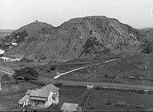
View looking west, made in 1920, showing Three Kings Road (later Mount Eden Road, foreground) and part of Te Tātua a
Riukiuta: Highest King is in the background to the left, with East King to its right.
569:
398:
or Tūpuna Maunga
Authority (TMA) is the co-governance organisation established to administer the 14 Tūpuna Maunga. Auckland Council manages the Tūpuna Maunga under the direction of the TMA.
1218:
769:
800:
222:
which still exist under the surface. Thus, rainwater falling on Te Tātua a
Riukiuta and the surrounding area is channeled underground for miles until it emerges at
79:
1211:
1348:
1450:
245:
drilled through Te Tātua a
Riukiuta lava flows in 2006 and carbon dating of the organic material produced six very similar dates around 28,500 years.
350:
to supply the water to the region. However, as a result of local opposition to this arrangement, the water is instead discarded into the sea. This
754:
1460:
1204:
1455:
793:
584:
469:
172:
741:
418:
Lindsay, J.M.; Leonard, G.S.; Smid, E.R.; Hayward, B.W. (December 2011). "Age of the
Auckland volcanic field: a review of existing data".
1419:
720:
549:
215:
659:
1445:
1227:
786:
608:"Ngā Mana Whenua o Tāmaki Makaurau Collective Redress Act 2014 No 52 (as at 12 April 2022), Public Act – New Zealand Legislation"
733:
565:
859:
1379:
1005:
346:
level became a problem for the quarry in 1995, and
Winstone Aggregates, the company operating the quarry, arranged with the
46:
963:
235:
865:
773:
265:
72:
324:, to assist his Waiohua relative Te Rauiti. Te Tātua a Riukiuta has retained Māori earthworks from that era such as
316:
confederation era of the 17th and 18th centuries. The stone walled pā was built by
Kowhatukiteuru, rangatira of the
877:
853:
317:
1374:
1184:
1172:
969:
328:
289:
waka who brought together diverse genealogical lines of the local tribes. The name Three Kings derives from the
1269:
1142:
1134:
176:
632:
981:
847:
809:
371:
223:
200:
160:
138:
570:"Local Area Plan: Te Henga (Bethells Beach) and the Waitākere River Valley. Waitākere Ranges Heritage Area"
257:
View north-east from the summit of Te Tātua a
Riukiuta, showing terracing on the slopes from when it was a
1409:
1264:
1249:
637:
607:
1414:
1387:
1326:
1254:
1028:
347:
285:
crater. It was later adapted to Te Tātua a
Riukiuta, which referred to Riukiuta, a senior priest of the
542:
Taua: 'musket wars', 'land wars' or tikanga?: warfare in Maori society in the early nineteenth century
1196:
1129:
737:
321:
1279:
1112:
1034:
835:
302:
1424:
1404:
1353:
1336:
1100:
763:
435:
367:
895:
253:
1058:
716:
580:
545:
465:
1369:
1160:
907:
883:
576:
427:
387:
1106:
1094:
1040:
829:
823:
231:
1070:
1064:
342:
However, the large scoria deposits in the surrounding area are still being quarried. The
918:
667:
1331:
1305:
1076:
1011:
999:
841:
537:
294:
131:
1439:
1341:
1321:
1295:
1259:
1166:
1118:
975:
957:
901:
439:
309:
298:
290:
155:
512:
488:
987:
951:
939:
325:
151:
123:
17:
1274:
746:
431:
241:
The eruption occurred 28,500 years ago. Charred twigs and wood were found in six
234:, but in 2008 it was discovered that the Meola Reef lava had come from the older
1235:
1154:
1088:
1046:
993:
889:
343:
1082:
355:
351:
282:
227:
179:
that erupted 28,500 years ago. The volcano had three prominent peaks known as
94:
81:
1178:
1148:
945:
933:
242:
219:
778:
1231:
119:
1052:
383:
313:
278:
214:
Lava flows ran from here down a stream valley for three kilometres to
207:
cones and about a dozen smaller scoria mounds, sitting inside a large
335:
286:
204:
184:
62:
305:. Big King refers to the second-highest (and only remaining) peak.
334:
The area has been drastically quarried over the years for the red
264:
258:
252:
199:
Te Tātua a Riukiuta was probably the most complex volcano in the
208:
1200:
782:
379:
460:
Hayward, Bruce W.; Murdoch, Graeme; Maitland, Gordon (2011).
386:(also known as the Tāmaki Collective), ownership of the 14
715:. Hayward, B.W.; Auckland University Press, 2019, 335 pp.
513:"Story: Tāmaki tribes Page 1 – Tribal history and places"
183:
and a number of smaller peaks until most of them were
1397:
1362:
1314:
1288:
1242:
1128:
1021:
926:
816:
187:away, leaving a sole remaining large peak known as
149:
144:
130:
115:
110:
71:
61:
56:
34:
413:
411:
774:Auckland War Memorial Museum Tāmaki Paenga Hira
540:(2003). "Tāmaki-makau-rau (Auckland isthmus)".
464:. Auckland University Press. pp. 141–145.
51:Te Tātua a Riukiuta seen from Three Kings Plaza
455:
453:
451:
449:
1212:
794:
420:New Zealand Journal of Geology and Geophysics
8:
308:Te Tātua a Riukiuta was once the site of a
281:), which referred to a deity living in the
1219:
1205:
1197:
801:
787:
779:
462:Volcanoes of Auckland: The Essential Guide
31:
396:Tūpuna Maunga o Tāmaki Makaurau Authority
691:"Tūpuna Maunga significance and history"
734:Watercolour of Te Tātua-a-Riukiuta 1875
631:Dearnaley, Mathew (27 September 2014).
407:
7:
1349:Puketāpapa Women's Suffrage Memorial
713:Volcanoes of Auckland: A Field Guide
483:
481:
273:An earlier name for the volcano was
27:Scoria cone in Auckland, New Zealand
633:"Volcanic cones regain Maori names"
770:Photographs of Te Tātua-a-Riukiuta
760:Photographs of Te Tātua-a-Riukiuta
544:. Auckland: Penguin. p. 206.
25:
1420:Mount Roskill Rugby Football Club
660:"NZGB decisions - September 2014"
376:Ngā Mana Whenua o Tāmaki Makaurau
203:, consisting of five significant
1451:Volcanoes of the Auckland Region
917:
224:Western Springs Te Wai Ōrea Lake
45:
1388:Auckland City Council (defunct)
169:Te Tātua a Riukiuta / Big King
1:
1155:Pupuke Moana / Pupuke Volcano
748:
1456:Hills of the Auckland Region
866:Maungakiekie / One Tree Hill
664:Land Information New Zealand
566:Waitākere Ranges Local Board
432:10.1080/00288306.2011.595805
236:Te Kōpuke / Mount Saint John
1461:Puketāpapa Local Board Area
1380:Albert-Eden-Puketāpapa ward
1228:Puketāpapa Local Board Area
1477:
1315:Facilities and attractions
378:collective of 13 Auckland
354:has led to concerns about
915:
44:
39:
1006:Ōtāhuhu / Mount Richmond
740:, in the collections of
295:Captain William Hobson's
177:Three Kings, New Zealand
175:(ancestral mountain) in
95:36.902926°S 174.754651°E
67:133 m (436 ft)
1446:Auckland volcanic field
946:Whakamuhu / Glover Park
878:Ōwairaka / Mount Albert
854:Ōhinerau / Mount Hobson
848:Maungawhau / Mount Eden
810:Auckland volcanic field
612:www.legislation.govt.nz
370:settlement between the
339:supply reservoir only.
201:Auckland volcanic field
161:Auckland volcanic field
139:Auckland volcanic field
1375:Puketāpapa Local Board
772:in the collections of
753:in the collections of
638:The New Zealand Herald
312:, occupied during the
270:
262:
218:. These flows created
100:-36.902926; 174.754651
1415:Mount Albert-Ponsonby
1327:Hillsborough Cemetery
489:"Te Tātua a Riukiuta"
348:Auckland City Council
268:
256:
766:heritage collections
747:View of the pā site
1301:Te Tātua a Riukiuta
1289:Geographic features
1035:Boggust Park Crater
872:Te Tātua a Riukiuta
836:Albert Park Volcano
764:Auckland Libraries'
689:Council, Auckland.
293:, and was named by
91: /
35:Te Tātua a Riukiuta
18:Te Tātua-a-Riukiuta
1425:Three Kings United
1405:Auckland United FC
1354:Waikaraka Cycleway
1337:Monte Cecilia Park
670:on 29 October 2014
368:Treaty of Waitangi
275:Te Tatua o Mataaho
271:
263:
57:Highest point
1433:
1432:
1194:
1193:
1130:Waitematā Harbour
755:Te Papa Tongarewa
586:978-0-908320-17-2
471:978-1-86940-479-6
362:Treaty settlement
322:Te Kawerau ā Maki
277:(the war belt of
171:is a volcano and
166:
165:
16:(Redirected from
1468:
1370:Auckland Council
1243:Populated places
1221:
1214:
1207:
1198:
1113:Māngere Mountain
921:
908:Little Rangitoto
884:Te Hopua a Rangi
860:Mount Saint John
824:Pukekawa Volcano
817:Central Auckland
803:
796:
789:
780:
750:
705:
704:
702:
701:
695:Auckland Council
686:
680:
679:
677:
675:
666:. Archived from
656:
650:
649:
647:
645:
628:
622:
621:
619:
618:
604:
598:
597:
595:
593:
577:Auckland Council
574:
568:(October 2015).
562:
556:
555:
534:
528:
527:
525:
523:
509:
503:
502:
500:
499:
485:
476:
475:
457:
444:
443:
415:
209:explosion crater
134:
106:
105:
103:
102:
101:
96:
92:
89:
88:
87:
84:
49:
32:
21:
1476:
1475:
1471:
1470:
1469:
1467:
1466:
1465:
1436:
1435:
1434:
1429:
1393:
1358:
1310:
1284:
1238:
1225:
1195:
1190:
1132:
1124:
1107:Puketutu Island
1095:Puhinui Craters
1041:Cemetery Crater
1017:
964:Pigeon Mountain
922:
913:
830:Grafton Volcano
812:
807:
730:
709:
708:
699:
697:
688:
687:
683:
673:
671:
658:
657:
653:
643:
641:
630:
629:
625:
616:
614:
606:
605:
601:
591:
589:
587:
572:
564:
563:
559:
552:
538:Ballara, Angela
536:
535:
531:
521:
519:
511:
510:
506:
497:
495:
487:
486:
479:
472:
459:
458:
447:
417:
416:
409:
404:
392:Tāmaki Makaurau
364:
331:and terracing.
251:
232:Point Chevalier
216:Western Springs
197:
132:
99:
97:
93:
90:
85:
82:
80:
78:
77:
52:
28:
23:
22:
15:
12:
11:
5:
1474:
1472:
1464:
1463:
1458:
1453:
1448:
1438:
1437:
1431:
1430:
1428:
1427:
1422:
1417:
1412:
1407:
1401:
1399:
1395:
1394:
1392:
1391:
1384:
1383:
1382:
1377:
1366:
1364:
1360:
1359:
1357:
1356:
1351:
1346:
1345:
1344:
1334:
1332:Keith Hay Park
1329:
1324:
1318:
1316:
1312:
1311:
1309:
1308:
1306:Wairaki Stream
1303:
1298:
1292:
1290:
1286:
1285:
1283:
1282:
1277:
1272:
1267:
1262:
1257:
1252:
1246:
1244:
1240:
1239:
1226:
1224:
1223:
1216:
1209:
1201:
1192:
1191:
1189:
1188:
1182:
1176:
1173:Mount Victoria
1170:
1164:
1158:
1152:
1146:
1139:
1137:
1126:
1125:
1123:
1122:
1116:
1110:
1104:
1098:
1092:
1086:
1080:
1077:Maungataketake
1074:
1068:
1062:
1059:Māngere Lagoon
1056:
1050:
1044:
1038:
1032:
1025:
1023:
1022:South Auckland
1019:
1018:
1016:
1015:
1012:Robertson Hill
1009:
1003:
1000:McLennan Hills
997:
991:
985:
979:
973:
967:
961:
955:
949:
943:
937:
930:
928:
924:
923:
916:
914:
912:
911:
905:
899:
893:
887:
881:
875:
869:
863:
857:
851:
845:
842:Te Pou Hawaiki
839:
833:
827:
820:
818:
814:
813:
808:
806:
805:
798:
791:
783:
777:
776:
767:
757:
744:
729:
728:External links
726:
725:
724:
707:
706:
681:
651:
623:
599:
585:
557:
550:
529:
504:
477:
470:
445:
426:(4): 379–401.
406:
405:
403:
400:
363:
360:
250:
247:
196:
193:
164:
163:
158:
147:
146:
142:
141:
136:
128:
127:
117:
113:
112:
108:
107:
75:
69:
68:
65:
59:
58:
54:
53:
50:
42:
41:
37:
36:
26:
24:
14:
13:
10:
9:
6:
4:
3:
2:
1473:
1462:
1459:
1457:
1454:
1452:
1449:
1447:
1444:
1443:
1441:
1426:
1423:
1421:
1418:
1416:
1413:
1411:
1408:
1406:
1403:
1402:
1400:
1398:Organisations
1396:
1390:
1389:
1385:
1381:
1378:
1376:
1373:
1372:
1371:
1368:
1367:
1365:
1361:
1355:
1352:
1350:
1347:
1343:
1342:Pah Homestead
1340:
1339:
1338:
1335:
1333:
1330:
1328:
1325:
1323:
1322:Dominion Road
1320:
1319:
1317:
1313:
1307:
1304:
1302:
1299:
1297:
1294:
1293:
1291:
1287:
1281:
1278:
1276:
1273:
1271:
1268:
1266:
1263:
1261:
1260:Mount Roskill
1258:
1256:
1253:
1251:
1248:
1247:
1245:
1241:
1237:
1233:
1229:
1222:
1217:
1215:
1210:
1208:
1203:
1202:
1199:
1186:
1183:
1180:
1177:
1174:
1171:
1168:
1167:Mount Cambria
1165:
1162:
1159:
1156:
1153:
1150:
1147:
1144:
1141:
1140:
1138:
1136:
1131:
1127:
1120:
1119:Pukaki Lagoon
1117:
1114:
1111:
1108:
1105:
1102:
1099:
1096:
1093:
1090:
1087:
1084:
1081:
1078:
1075:
1072:
1069:
1066:
1063:
1060:
1057:
1054:
1051:
1048:
1045:
1042:
1039:
1036:
1033:
1030:
1027:
1026:
1024:
1020:
1013:
1010:
1007:
1004:
1001:
998:
995:
992:
989:
986:
983:
980:
977:
974:
971:
968:
965:
962:
959:
958:Panmure Basin
956:
953:
950:
947:
944:
941:
938:
935:
932:
931:
929:
927:East Auckland
925:
920:
909:
906:
903:
900:
897:
894:
891:
888:
885:
882:
879:
876:
873:
870:
867:
864:
861:
858:
855:
852:
849:
846:
843:
840:
837:
834:
831:
828:
825:
822:
821:
819:
815:
811:
804:
799:
797:
792:
790:
785:
784:
781:
775:
771:
768:
765:
761:
758:
756:
752:
745:
743:
739:
735:
732:
731:
727:
722:
721:0-582-71784-1
718:
714:
711:
710:
696:
692:
685:
682:
669:
665:
661:
655:
652:
640:
639:
634:
627:
624:
613:
609:
603:
600:
588:
582:
578:
571:
567:
561:
558:
553:
551:9780143018896
547:
543:
539:
533:
530:
518:
514:
508:
505:
494:
493:www.maunga.nz
490:
484:
482:
478:
473:
467:
463:
456:
454:
452:
450:
446:
441:
437:
433:
429:
425:
421:
414:
412:
408:
401:
399:
397:
393:
389:
388:Tūpuna Maunga
385:
381:
377:
373:
369:
361:
359:
357:
353:
349:
345:
340:
337:
332:
330:
327:
323:
319:
318:West Auckland
315:
311:
306:
304:
300:
299:Felton Mathew
296:
292:
291:biblical Magi
288:
284:
280:
276:
267:
260:
255:
248:
246:
244:
239:
237:
233:
229:
225:
221:
217:
212:
210:
206:
202:
194:
192:
190:
186:
182:
178:
174:
173:Tūpuna Maunga
170:
162:
159:
157:
153:
148:
143:
140:
137:
135:
129:
126:, New Zealand
125:
121:
118:
114:
109:
104:
76:
74:
70:
66:
64:
60:
55:
48:
43:
38:
33:
30:
19:
1386:
1300:
1250:Hillsborough
1071:Matukutūruru
1065:Matukutūreia
988:Styaks Swamp
970:Hampton Park
952:Taylors Hill
940:Purchas Hill
896:Ōrākei Basin
871:
742:Toi o Tāmaki
712:
698:. Retrieved
694:
684:
672:. Retrieved
668:the original
663:
654:
642:. Retrieved
636:
626:
615:. Retrieved
611:
602:
590:. Retrieved
560:
541:
532:
520:. Retrieved
516:
507:
496:. Retrieved
492:
461:
423:
419:
395:
391:
375:
366:In the 2014
365:
341:
333:
307:
274:
272:
240:
220:lava tunnels
213:
198:
188:
180:
168:
167:
133:Parent range
124:North Island
29:
1270:Three Kings
1236:New Zealand
1135:North Shore
1047:Crater Hill
994:Pukewairiki
890:Mount Smart
738:John Kinder
344:groundwater
181:Three Kings
98: /
86:174°45′17″E
73:Coordinates
1440:Categories
1363:Government
1296:Puketāpapa
1143:Maungauika
1083:Waitomokia
982:Green Hill
976:Ōtara Hill
902:Puketāpapa
700:2022-07-17
674:25 October
644:25 October
617:2022-07-17
522:1 November
498:2022-07-19
402:References
356:subsidence
352:dewatering
283:Maungawhau
228:Meola Reef
83:36°54′11″S
1275:Waikōwhai
1265:Royal Oak
1179:Tank Farm
1161:Rangitoto
1149:Motukorea
934:Maungarei
440:129707270
297:surveyor
243:boreholes
238:volcano.
150:Volcanic
111:Geography
63:Elevation
1410:Metro FC
1255:Lynfield
1232:Auckland
1089:Ōtuataua
1029:Ash Hill
762:held in
374:and the
189:Big King
185:quarried
120:Auckland
116:Location
40:Big King
1185:Onepoto
1101:Pukeiti
1053:Kohuora
314:Waiohua
279:Mataaho
249:History
195:Geology
145:Geology
1280:Wesley
719:
592:15 May
583:
548:
517:Te Ara
468:
438:
336:scoria
326:kumara
287:Tainui
205:scoria
573:(PDF)
436:S2CID
372:Crown
261:site.
1133:and
1121:(44)
1115:(37)
1109:(39)
1103:(41)
1097:(53)
1091:(42)
1085:(40)
1079:(43)
1073:(48)
1067:(47)
1061:(38)
1055:(46)
1049:(45)
1043:(52)
1037:(51)
1031:(49)
1014:(30)
1008:(28)
1002:(29)
996:(31)
990:(35)
984:(34)
978:(33)
972:(32)
966:(36)
960:(25)
954:(22)
948:(21)
942:(23)
936:(24)
910:(19)
904:(14)
898:(20)
892:(26)
886:(27)
880:(13)
874:(15)
868:(16)
862:(17)
856:(18)
850:(11)
844:(12)
832:(50)
826:(10)
751:1904
717:ISBN
676:2014
646:2014
594:2022
581:ISBN
546:ISBN
524:2014
466:ISBN
384:hapū
382:and
329:pits
320:iwi
303:1841
156:belt
1187:(3)
1181:(2)
1175:(4)
1169:(5)
1163:(7)
1157:(1)
1151:(8)
1145:(6)
838:(9)
736:by
428:doi
390:of
380:iwi
301:in
230:at
152:arc
1442::
1234:,
1230:,
749:c.
693:.
662:.
635:.
610:.
579:.
575:.
515:.
491:.
480:^
448:^
434:.
424:54
422:.
410:^
358:.
310:pā
259:pā
191:.
122:,
1220:e
1213:t
1206:v
802:e
795:t
788:v
723:.
703:.
678:.
648:.
620:.
596:.
554:.
526:.
501:.
474:.
442:.
430::
154:/
20:)
Text is available under the Creative Commons Attribution-ShareAlike License. Additional terms may apply.