98:
289:. It is the most visited nature reserve in the Russian Federation, with over 200,000 recorded in 2010. Included in the reserve are a popular tourist complex ("Dombay") and resorts in the surrounding areas. The terrain show extremes in variation: 31.7% forests, 20% meadows, 8.5% glaciers, 38.4% rock and scree, 0.7% water (there are 157 lakes and 109 glaciers). The reserve is divided into two sections - the Tebardinsky (65,792 hectares (162,580 acres)) to the east, and the Arkhyz (19,272 hectares (47,620 acres)) to the west. The two sections were connected in 2010 by a "biosphere polygon", the Caucasus State Nature Reserve. The two sectors are situated in the
371:
360:
southern areas of the reserve are coniferous forest, and the lower floodplains of the
Teberda River feature stands of alder. The alpine zones are alpine heath and meadow. There are 46 species of mammals living on the territory, with 1,300-1,600 of the Caucasian ibex, which have large saber horns reaching 1 meter in length on old males. Bison have been reintroduced into the area after being exterminated in 1926; the reserve's wild bison numbered 32 as of 2015. Recently, the jackal has penetrated the territory and is now the most common predator.
70:
310:
126:
514:
133:
105:
77:
351:). This climate is characterised by long cold winters, and short, cool summers. The average temperature in January is 2.9 °C, and in July is +15.5 °C. The average frost-free period is 126 days. Snow cover lasts from 21 to 122 days, an average of 73 days. As altitude increases, precipitation increases, and the temperature drops an average of 0.5 °C per 100 meters of ascent.
56:
306:
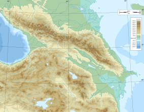
4,047 meters above sea level. The highest peaks in the area are Dombay-Ulgen (4042 m), Boo-Ulgen (3915 meters), Dzhalovchat (3870 meters), and Bela Kaya (3861 meters). The mountains were formed by tectonic forces, and the longitudinal valleys carved by two main periods of glaciation, one in the
Jurassic, and the other the more recent.
383:
Much of the
Teberda Reserve is a strictly protected nature zone, closed to the general public. There are many 'ecotourist' routes in the reserve, however, that are open to the public, with permits available for purchase the reserve offices or at the trail head of Dombay. There is an extensive tourist
317:
There are 109 glaciers, with a total area of 74.3 km2, and extensive snowfields on the mountains. Feeding streams on steep slopes, the glaciers form powerful rapids and waterfalls. There are 157 lakes are concentrated on the territory, with a maximum depth of 30–50 meters, and most above an altitude
305:
The
Teberda Reserve's southern border runs along the Main Caucasus ridge from the peak "Klukhori" to the peak "Herzog". The eastern section, Tebardinsky, covers the headwaters of the Tebarda River. The western section, Arkhyz, is the valley of the Kyzgych River. The altitude varies between 1,260 and
359:
Strong altitude zoning drives the plants in the reserve, with five levels (in ascending order): forest, sub-alpine (2,000 - 2,500 meters), alpine (2,500 - 3,000 meters), sub-nival, and nival (snow). The forest zone (34%) is dominated by pine, with an under story of juniper and rhododendron. The
332:
ecoregion. Located along the
Caucasus Mountains between the Black Sea and the Caspian Sea. One of the highest levels of species endemism and diversity in the world: 23% of vascular species, and 10% of vertebrates.
370:
97:
363:
There are three fishes in the streams of the reserve: brown trout, common minnow and
European loach. Teberda is an important bird area, with 226 species recorded. The near-threatened
518:
471:
439:
248:
69:
574:
1210:
1215:
178:
125:
297:. It is part of a UNESCO World Biosphere Reserve. The reserve was created in 1936, and covers an area of 84,996 ha (328.17 sq mi).
1205:
1084:
831:
1200:
673:
1069:
973:
795:
688:
567:
1033:
1003:
713:
343:
744:
993:
958:
877:
41:
749:
668:
1094:
902:
785:
622:
560:
552:
1164:
1139:
1089:
892:
846:
663:
1109:
1023:
968:
953:
841:
698:
637:
612:
597:
294:
156:
1159:
1114:
907:
856:
816:
617:
602:
542:
403:
338:
1169:
1124:
988:
912:
882:
836:
821:
739:
658:
398:
1134:
1043:
1028:
1013:
1008:
998:
948:
826:
775:
770:
723:
718:
1154:
1144:
1104:
963:
861:
851:
703:
693:
642:
328:
309:
290:
384:
infrastructure on the entrance to the reserve, including hotels, restaurants, and conference facilities.
1129:
1119:
1099:
1079:
1074:
1059:
1018:
943:
897:
811:
754:
678:
632:
627:
607:
45:
1064:
1038:
983:
933:
917:
887:
408:
1220:
1179:
1149:
978:
938:
780:
708:
286:
347:
492:
374:
Caucasian black grouse, a resident of the
Teberda Reserve. 1-Ruble silver coin, Russia, 1995
364:
270:
27:
285:' (strict ecological reserve) located on the northern slopes of the western section of the
1174:
1194:
683:
222:
583:
393:
282:
435:
193:
180:
55:
214:
166:
547:
467:
369:
308:
218:
556:
367:
is a resident of the reserve, and endemic to the
Caucasus.
258:
394:
List of
Russian Nature Reserves (class 1a 'zapovedniks')
519:
Ministry of
Natural Resources and Environment (Russia)
472:
Ministry of Natural Resources and Environment (Russia)
440:
Ministry of Natural Resources and Environment (Russia)
249:
Ministry of Natural Resources and Environment (Russia)
1052:
926:
870:
804:
763:
732:
651:
590:
254:
244:
229:
209:
172:
162:
152:
21:
584:Nature reserves of Russia (class Ia 'Zapovedniks')
132:
104:
76:
568:
430:
428:
426:
424:
16:Nature reserve in Karachay-Cherkessia, Russia
8:
436:"Teberda Zapovednik - About (Official Site)"
140:Teberda Nature Reserve (Caucasus Mountains)
575:
561:
553:
18:
112:Teberda Nature Reserve (European Russia)
548:Map of Teberda Reserve, ProtectedPlanet
420:
462:
460:
458:
456:
339:Humid continental climate, cool summer
543:Map of Teberda Reserve, OpenStreetMap
7:
151:
1211:Protected areas established in 1936
14:
1216:Geography of Karachay-Cherkessia
131:
124:
103:
96:
75:
68:
54:
228:
161:
87:Show map of Karachay-Cherkessia
143:Show map of Caucasus Mountains
1:
1206:1936 establishments in Russia
344:Köppen climate classification
115:Show map of European Russia
1237:
336:The climate of Teberda is
326:Teberda is located in the
295:Karachay-Cherkess Republic
157:Karachay-Cherkess Republic
1201:Nature reserves in Russia
404:Protected areas of Russia
274:
62:
53:
39:
31:
26:
399:National parks of Russia
745:Bogdinsko-Baskunchakski
32:Тебердинский заповедник
1085:Dalnevostochny Morskoy
832:Privolzhskaya Lesostep
375:
365:Caucasian black grouse
329:Caucasus mixed forests
314:
291:Karachayevsky District
267:Teberda Nature Reserve
259:http://teberda.org.ru/
22:Teberda Nature Reserve
373:
322:Climate and Ecoregion
312:
194:43.35000°N 41.70000°E
46:strict nature reserve
674:Central Tsernozemsky
493:"Climate of Teberda"
468:"Teberda Zapovednik"
409:Main Caucasian Range
796:Kabardino-Balkarski
245:Governing body
190: /
84:Location of Reserve
35:(Also: Teberdinsky)
1070:Bolshekhekhtsirsky
689:Kaluzhskiye Zaseki
495:. GloalSpecies.org
376:
315:
287:Caucasus Mountains
199:43.35000; 41.70000
1188:
1187:
1004:Sayano-Shushenski
714:Prioksko-Terrasny
318:of 2,000 meters.
264:
263:
163:Nearest city
1228:
577:
570:
563:
554:
530:
529:
527:
525:
511:
505:
504:
502:
500:
489:
483:
482:
480:
478:
464:
451:
450:
448:
446:
432:
281:) is a Russian '
276:
240:
238:
205:
204:
202:
201:
200:
195:
191:
188:
187:
186:
183:
144:
135:
134:
128:
116:
107:
106:
100:
88:
79:
78:
72:
58:
33:
19:
1236:
1235:
1231:
1230:
1229:
1227:
1226:
1225:
1191:
1190:
1189:
1184:
1048:
994:Kuznetsk Alatau
959:Central Siberia
922:
878:Denezhkin Kamen
866:
857:Vosshko-Kamisky
800:
759:
728:
647:
586:
581:
539:
534:
533:
523:
521:
515:"Teberda-Flora"
513:
512:
508:
498:
496:
491:
490:
486:
476:
474:
466:
465:
454:
444:
442:
434:
433:
422:
417:
390:
381:
357:
355:Flora and fauna
324:
303:
236:
234:
198:
196:
192:
189:
184:
181:
179:
177:
176:
148:
147:
146:
145:
142:
141:
138:
137:
136:
119:
118:
117:
114:
113:
110:
109:
108:
91:
90:
89:
86:
85:
82:
81:
80:
49:
34:
17:
12:
11:
5:
1234:
1232:
1224:
1223:
1218:
1213:
1208:
1203:
1193:
1192:
1186:
1185:
1183:
1182:
1177:
1175:Wrangel Island
1172:
1167:
1162:
1157:
1152:
1147:
1142:
1137:
1132:
1127:
1122:
1117:
1112:
1107:
1102:
1097:
1092:
1087:
1082:
1077:
1072:
1067:
1062:
1056:
1054:
1050:
1049:
1047:
1046:
1041:
1036:
1034:Ubsunur Hollow
1031:
1026:
1021:
1016:
1011:
1006:
1001:
996:
991:
986:
981:
976:
971:
966:
961:
956:
951:
946:
941:
936:
930:
928:
924:
923:
921:
920:
915:
910:
905:
900:
895:
890:
885:
880:
874:
872:
868:
867:
865:
864:
859:
854:
849:
844:
839:
834:
829:
824:
819:
814:
808:
806:
802:
801:
799:
798:
793:
788:
783:
778:
773:
767:
765:
764:North Caucasus
761:
760:
758:
757:
752:
750:Chyornye Zemli
747:
742:
736:
734:
730:
729:
727:
726:
721:
716:
711:
706:
701:
696:
691:
686:
681:
676:
671:
669:Central Forest
666:
664:Bryansk Forest
661:
655:
653:
649:
648:
646:
645:
640:
635:
630:
625:
620:
615:
610:
605:
600:
594:
592:
588:
587:
582:
580:
579:
572:
565:
557:
551:
550:
545:
538:
537:External links
535:
532:
531:
517:(in Russian).
506:
484:
470:(in Russian).
452:
438:(in Russian).
419:
418:
416:
413:
412:
411:
406:
401:
396:
389:
386:
380:
377:
356:
353:
323:
320:
302:
299:
262:
261:
256:
252:
251:
246:
242:
241:
231:
227:
226:
211:
207:
206:
174:
170:
169:
164:
160:
159:
154:
150:
149:
139:
130:
129:
123:
122:
121:
120:
111:
102:
101:
95:
94:
93:
92:
83:
74:
73:
67:
66:
65:
64:
63:
60:
59:
51:
50:
40:
37:
36:
24:
23:
15:
13:
10:
9:
6:
4:
3:
2:
1233:
1222:
1219:
1217:
1214:
1212:
1209:
1207:
1204:
1202:
1199:
1198:
1196:
1181:
1178:
1176:
1173:
1171:
1168:
1166:
1163:
1161:
1158:
1156:
1153:
1151:
1148:
1146:
1143:
1141:
1138:
1136:
1133:
1131:
1128:
1126:
1123:
1121:
1118:
1116:
1113:
1111:
1108:
1106:
1103:
1101:
1098:
1096:
1095:Kedrovaya Pad
1093:
1091:
1088:
1086:
1083:
1081:
1078:
1076:
1073:
1071:
1068:
1066:
1063:
1061:
1058:
1057:
1055:
1051:
1045:
1042:
1040:
1037:
1035:
1032:
1030:
1027:
1025:
1022:
1020:
1017:
1015:
1012:
1010:
1007:
1005:
1002:
1000:
997:
995:
992:
990:
987:
985:
982:
980:
977:
975:
972:
970:
967:
965:
962:
960:
957:
955:
952:
950:
947:
945:
942:
940:
937:
935:
932:
931:
929:
925:
919:
916:
914:
911:
909:
906:
904:
903:Pechoro-Ilych
901:
899:
896:
894:
891:
889:
886:
884:
881:
879:
876:
875:
873:
869:
863:
860:
858:
855:
853:
850:
848:
845:
843:
840:
838:
835:
833:
830:
828:
825:
823:
820:
818:
815:
813:
810:
809:
807:
803:
797:
794:
792:
789:
787:
786:North Ossetia
784:
782:
779:
777:
774:
772:
769:
768:
766:
762:
756:
753:
751:
748:
746:
743:
741:
738:
737:
735:
731:
725:
722:
720:
717:
715:
712:
710:
707:
705:
702:
700:
697:
695:
692:
690:
687:
685:
684:Galichya Gora
682:
680:
677:
675:
672:
670:
667:
665:
662:
660:
657:
656:
654:
650:
644:
641:
639:
636:
634:
631:
629:
626:
624:
623:Nizhnesvirsky
621:
619:
616:
614:
611:
609:
606:
604:
601:
599:
596:
595:
593:
589:
585:
578:
573:
571:
566:
564:
559:
558:
555:
549:
546:
544:
541:
540:
536:
520:
516:
510:
507:
494:
488:
485:
473:
469:
463:
461:
459:
457:
453:
441:
437:
431:
429:
427:
425:
421:
414:
410:
407:
405:
402:
400:
397:
395:
392:
391:
387:
385:
378:
372:
368:
366:
361:
354:
352:
350:
349:
345:
341:
340:
334:
331:
330:
321:
319:
311:
307:
300:
298:
296:
292:
288:
284:
280:
272:
268:
260:
257:
253:
250:
247:
243:
232:
224:
220:
216:
212:
208:
203:
175:
171:
168:
165:
158:
155:
127:
99:
71:
61:
57:
52:
47:
43:
42:IUCN category
38:
29:
25:
20:
1165:Sikhote-Alin
1090:Dzhugdzursky
974:Great Arctic
893:Little Sosva
847:Shulgan-Tash
790:
522:. Retrieved
509:
497:. Retrieved
487:
475:. Retrieved
443:. Retrieved
382:
362:
358:
346:
337:
335:
327:
325:
316:
313:Mount Dombay
304:
278:
275:Тебердинский
266:
265:
1024:Tigirekskiy
969:Dzherginsky
954:Baykal-Lena
842:Shaytan-Tau
699:Kologrivsky
638:Polistovsky
613:Kostomuksha
598:Kandalaksha
499:January 21,
477:January 21,
445:January 21,
279:Teberdinsky
230:Established
221:; 328
197: /
173:Coordinates
1221:Zapovednik
1195:Categories
1160:Poronaysky
1140:Lena Delta
1115:Komsomolsk
908:South Ural
817:Bashkirski
603:Kerzhinski
415:References
379:Ecotourism
301:Topography
283:zapovednik
223:sq mi
1170:Ussurisky
1125:Kronotsky
989:Khakasski
944:Baikalsky
913:Upper Taz
883:East Ural
837:Prisursky
822:Mordovski
740:Astrakhan
659:Belogorye
591:Northwest
524:April 17,
217:(210,030
185:41°42′0″E
182:43°21′0″N
1135:Lazovsky
1110:Komandor
1053:Far East
1044:Yugansky
1029:Tunguska
1009:Sokhondo
999:Putorana
949:Barguzin
862:Zhiguili
827:Orenburg
776:Dagestan
771:Caucasus
733:Southern
724:Voronina
719:Voronezh
388:See also
277:) (also
215:hectares
153:Location
1155:Olyokma
1145:Magadan
1105:Khingan
964:Dauriya
927:Siberia
852:Vishera
791:Teberda
704:Nurgush
694:Khopyor
652:Central
643:Rdeysky
618:Lapland
293:of the
271:Russian
255:Website
235: (
213:84,996
167:Teberda
28:Russian
1130:Kurils
1120:Koryak
1100:Khanka
1080:Bureya
1075:Botcha
1060:Bastak
1019:Taymyr
1014:Stolby
898:Nenets
812:Basegi
755:Rostov
679:Darwin
633:Pinega
628:Pasvik
608:Kivach
1065:Bolon
1039:Vitim
984:Katun
934:Altai
918:Visim
888:Ilmen
871:Urals
805:Volga
348:(Dfc)
219:acres
1180:Zeya
1150:Nora
979:Gyda
939:Azas
781:Erzi
526:2016
501:2016
479:2016
447:2016
237:1936
233:1936
210:Area
44:Ia (
709:Oka
1197::
455:^
423:^
273::
30::
576:e
569:t
562:v
528:.
503:.
481:.
449:.
342:(
269:(
239:)
225:)
48:)
Text is available under the Creative Commons Attribution-ShareAlike License. Additional terms may apply.