525:
654:
31:
921:
903:
This template can also be used inside an article, in a section dedicated to an important volcanic eruption. In these cases, the volcano, location, coordinates, and map should be left out, as they are redundant to the main article infobox (presumably
291:. If the timing is incomplete (common for extremely old eruptions), use as specific a time period as you may in place of the year. Many eruptions have names given to them by the scientific community, if one exists, use it!
506:
What was the impact of the eruption? How many lives were lost? How much property damage? What was the impact of the eruption on the local and global landscape? Basically, why is the eruption notable?
301:
Photo of the eruption. A painting or other representation may be used for eruptions preceding the invention of photography. Precede filename with "File:" but do not use brackets.
456:; the type of eruption can be inferred off its VEI, and this field also automatically adds the volcano to the respective "VEI-level volcanoes" category.
61:
This infobox is meant to be used on pages about volcanic eruptions and on the sections of articles about a volcano about an eruption, but
598:
288:
38:
524:
896:
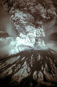
57 deaths, $ 1.1 billion in property damage; caused a partial collapse of the volcano's flank, deposited ash in 11 states
643:
57 deaths, $ 1.1 billion in property damage; caused a partial collapse of the volcano's flank, deposited ash in 11 states
287:
Name of the eruption. The conventions for naming relatively modern eruptions is to use " eruption of ". See for instance
1131:
Pre-eruption earthquakes killed at least 35 people; caused an evacuation and significant changes to the local topology.
968:
Pre-eruption earthquakes killed at least 35 people; caused an evacuation and significant changes to the local topology.
943:
588:
565:
392:
653:
955:
630:
449:
331:
Date of eruption; should be used for one day eruptions or when the start and end dates of an eruption are unknown.
905:
69:
46:
17:
52:
470:
1026:
was covered by deep ash during the 1914 eruption of the
Sakurajima, which is visible across the bay.
929:
was covered by deep ash during the 1914 eruption of the
Sakurajima, which is visible across the bay.
592:
41:
948:
578:
570:
574:
542:
530:
416:
453:
613:
600:
65:
as the main template on the pages of the volcanoes themselves (for that, use
926:
920:
476:
template in place of a "hard" image map (use width = 250, with caption = )
311:
Size of the photo; leaving this blank will cause it to default to 250px.
55:
and other content that is not part of the original template page.
75:). The completely expanded form of the template is as follows:
25:
429:
Areal extent of lava or tephra released during an eruption.
351:
Start time of eruption; should be as specific as allowable.
341:
Start date of eruption; should be as specific as allowable.
695:
MSH80 eruption mount st helens 05-18-80-dramatic-edit.jpg
405:
Location of the volcano, e.g. "Boulder
Springs, Colorado"
371:
End time of eruption; should be as specific as allowable.
361:
End date of eruption; should be as specific as allowable.
439:
Amount of lava or tephra released during an eruption.
466:
Map of the eruption, if there is one. You can use a
452:, a measure of an eruption's strength similar to the
270:
964:
954:
942:
934:
913:
647:
639:
629:
584:
564:
556:
548:
538:
517:
867:St helens map showing 1980 eruption deposits.png
381:Name of the volcano where the eruption occurred.
8:
919:
652:
910:
514:
7:
685:1980 eruption of Mount St. Helens
51:It may contain usage information,
24:
518:1980 eruption of Mount St. Helens
415:Coordinates of the volcano. Use
289:1980 eruption of Mount St. Helens
523:
29:
1:
993:1914 eruption of Sakurajima
914:1914 eruption of Sakurajima
486:Same as image_size, above.
393:Types of volcanic eruptions
1152:
886:Map of eruption deposits
512:Here is an example usage:
450:Volcanic explosivity index
918:
906:Template:Infobox mountain
665:created with this source:
651:
522:
395:for the different types.
276:
273:
47:Template:Infobox eruption
18:Template:Infobox eruption
976:
668:
658:Map of eruption deposits
77:
321:Caption for the photo.
614:46.20028°N 122.18667°W
391:Type of eruption, see
496:Caption for the map.
1003:Kagoshima 1914.jpg
619:46.20028; -122.18667
610: /
715:Photograph of the
529:Photograph of the
44:
972:
971:
908:). For instance:
663:
662:
510:
509:
59:
58:
36:
1143:
1134:
1130:
1127:
1124:
1121:
1118:
1115:
1112:
1109:
1106:
1103:
1100:
1097:
1093:
1090:
1087:
1084:
1081:
1078:
1075:
1072:
1069:
1066:
1063:
1060:
1057:
1054:
1051:
1048:
1045:
1042:
1039:
1035:
1032:
1029:
1025:
1021:
1018:
1015:
1012:
1009:
1006:
1002:
999:
996:
992:
989:
986:
983:
982:Infobox eruption
980:
923:
911:
899:
895:
892:
889:
885:
882:
879:
876:
873:
870:
866:
863:
860:
856:
853:
850:
847:
843:
840:
837:
833:
829:
825:
821:
817:
813:
809:
805:
802:
799:
796:
793:
790:
787:
783:
780:
777:
774:
771:
767:
763:
760:
757:
754:
751:
748:
745:
742:
739:12:36 p.m. PDT
738:
735:
732:
729:March 27, 1980
728:
725:
722:
719:, May 18, 1980
718:
714:
711:
708:
704:
701:
698:
694:
691:
688:
684:
681:
678:
675:
674:Infobox eruption
672:
656:
625:
624:
622:
621:
620:
615:
611:
608:
607:
606:
603:
543:Mount St. Helens
527:
515:
475:
469:
271:
267:
264:
261:
258:
255:
252:
249:
246:
243:
240:
237:
234:
231:
228:
225:
222:
219:
216:
213:
210:
207:
204:
201:
198:
195:
192:
189:
186:
183:
180:
177:
174:
171:
168:
165:
162:
159:
156:
153:
150:
147:
144:
141:
138:
135:
132:
129:
126:
123:
120:
117:
114:
111:
108:
105:
102:
99:
96:
93:
90:
87:
84:
83:Infobox eruption
81:
74:
70:Infobox mountain
68:
33:
32:
26:
1151:
1150:
1146:
1145:
1144:
1142:
1141:
1140:
1138:
1136:
1135:
1132:
1128:
1125:
1122:
1119:
1116:
1113:
1110:
1107:
1104:
1101:
1098:
1095:
1091:
1088:
1085:
1082:
1079:
1076:
1073:
1070:
1067:
1064:
1061:
1058:
1055:
1052:
1049:
1046:
1043:
1040:
1037:
1033:
1030:
1027:
1023:
1019:
1016:
1013:
1010:
1007:
1004:
1000:
997:
994:
990:
987:
984:
981:
978:
930:
901:
900:
897:
893:
890:
887:
883:
880:
877:
874:
871:
868:
864:
861:
858:
854:
851:
848:
845:
841:
838:
835:
831:
827:
823:
819:
815:
811:
807:
803:
800:
797:
794:
791:
788:
785:
781:
778:
775:
772:
769:
765:
761:
758:
755:
752:
749:
746:
743:
740:
736:
733:
730:
726:
723:
720:
716:
712:
709:
706:
702:
699:
696:
692:
689:
686:
682:
679:
676:
673:
670:
666:
659:
618:
616:
612:
609:
604:
601:
599:
597:
596:
595:
589:Skamania County
534:
531:eruption column
473:
467:
269:
268:
265:
262:
259:
256:
253:
250:
247:
244:
241:
238:
235:
232:
229:
226:
223:
220:
217:
214:
211:
208:
205:
202:
199:
196:
193:
190:
187:
184:
181:
178:
175:
172:
169:
166:
163:
160:
157:
154:
151:
148:
145:
142:
139:
136:
133:
130:
127:
124:
121:
118:
115:
112:
109:
106:
103:
100:
97:
94:
91:
88:
85:
82:
79:
72:
66:
50:
30:
22:
21:
20:
12:
11:
5:
1149:
1147:
1036:January 1914
977:
970:
969:
966:
962:
961:
958:
952:
951:
946:
940:
939:
936:
932:
931:
924:
916:
915:
669:
661:
660:
657:
649:
648:
645:
644:
641:
637:
636:
633:
627:
626:
586:
582:
581:
568:
562:
561:
560:12:36 p.m. PDT
558:
554:
553:
552:March 27, 1980
550:
546:
545:
540:
536:
535:
533:, May 18, 1980
528:
520:
519:
508:
507:
504:
498:
497:
494:
488:
487:
484:
478:
477:
464:
458:
457:
447:
441:
440:
437:
431:
430:
427:
421:
420:
417:Template:Coord
413:
407:
406:
403:
397:
396:
389:
383:
382:
379:
373:
372:
369:
363:
362:
359:
353:
352:
349:
343:
342:
339:
333:
332:
329:
323:
322:
319:
313:
312:
309:
303:
302:
299:
293:
292:
285:
279:
278:
275:
78:
57:
56:
34:
23:
15:
14:
13:
10:
9:
6:
4:
3:
2:
1148:
1139:
975:
967:
963:
959:
957:
953:
950:
947:
945:
941:
937:
933:
928:
922:
917:
912:
909:
907:
667:
655:
650:
646:
642:
638:
634:
632:
628:
623:
594:
590:
587:
583:
580:
576:
572:
569:
567:
563:
559:
555:
551:
547:
544:
541:
537:
532:
526:
521:
516:
513:
505:
503:
500:
499:
495:
493:
490:
489:
485:
483:
480:
479:
472:
465:
463:
460:
459:
455:
454:Richter scale
451:
448:
446:
443:
442:
438:
436:
433:
432:
428:
426:
423:
422:
418:
414:
412:
409:
408:
404:
402:
399:
398:
394:
390:
388:
385:
384:
380:
378:
375:
374:
370:
368:
365:
364:
360:
358:
355:
354:
350:
348:
345:
344:
340:
338:
335:
334:
330:
328:
325:
324:
320:
318:
315:
314:
310:
308:
305:
304:
300:
298:
295:
294:
290:
286:
284:
281:
280:
272:
76:
71:
64:
54:
48:
43:
40:
39:documentation
35:
28:
27:
19:
1137:
1117:map_caption
1080:coordinates
1022:The city of
973:
938:January 1914
925:The city of
902:
881:map_caption
792:coordinates
664:
511:
501:
491:
481:
474:}}
471:Location map
468:{{
461:
444:
434:
424:
410:
400:
386:
376:
366:
356:
346:
336:
326:
316:
306:
296:
282:
260:impact
251:map_caption
242:map_size
233:map
224:VEI
215:volume
206:area
197:coordinates
188:location
179:type
170:volcano
161:end_time
152:end_date
143:start_time
134:start_date
125:date
116:caption
107:image_size
98:image
89:name
73:}}
67:{{
62:
60:
1041:start_time
1031:start_date
1008:image_size
734:start_time
724:start_date
700:image_size
617: /
605:122°11′12″W
492:map_caption
411:coordinates
274:Field name
935:Start date
593:Washington
557:Start time
549:Start date
347:start_time
337:start_date
307:image_size
53:categories
37:This is a
1108:map_size
1071:location
927:Kagoshima
872:map_size
776:location
602:46°12′1″N
1050:volcano
1017:caption
974:Source:
744:volcano
710:caption
585:Location
571:Phreatic
482:map_size
401:location
367:end_time
357:end_date
1126:impact
891:impact
839:display
705:200px
575:Plinian
539:Volcano
377:volcano
317:caption
42:subpage
998:image
965:Impact
949:Peléan
844:inline
690:image
640:Impact
579:Peléan
502:impact
435:volume
277:Input
1059:type
988:name
801:coord
756:type
680:name
297:image
16:<
1099:map
1089:VEI
944:Type
862:map
852:VEI
566:Type
425:area
387:type
327:date
283:name
45:for
1094:4
956:VEI
857:5
822:122
631:VEI
462:map
445:VEI
63:not
1133:}}
979:{{
898:}}
846:}}
830:12
826:11
810:12
806:46
798:{{
784:,
768:,
764:,
671:{{
591:,
577:,
573:,
419:.
266:}}
80:{{
1129:=
1123:|
1120:=
1114:|
1111:=
1105:|
1102:=
1096:|
1092:=
1086:|
1083:=
1077:|
1074:=
1068:|
1065:]
1062:=
1056:|
1053:=
1047:|
1044:=
1038:|
1034:=
1028:|
1024:]
1020:=
1014:|
1011:=
1005:|
1001:=
995:|
991:=
985:|
960:4
894:=
888:|
884:=
878:|
875:=
869:|
865:=
859:|
855:=
849:|
842:=
836:|
834:W
832:|
828:|
824:|
820:|
818:N
816:|
814:1
812:|
808:|
804:|
795:=
789:|
786:]
782:]
779:=
773:|
770:]
766:]
762:]
759:=
753:|
750:]
747:=
741:|
737:=
731:|
727:=
721:|
717:]
713:=
707:|
703:=
697:|
693:=
687:|
683:=
677:|
635:5
263:=
257:|
254:=
248:|
245:=
239:|
236:=
230:|
227:=
221:|
218:=
212:|
209:=
203:|
200:=
194:|
191:=
185:|
182:=
176:|
173:=
167:|
164:=
158:|
155:=
149:|
146:=
140:|
137:=
131:|
128:=
122:|
119:=
113:|
110:=
104:|
101:=
95:|
92:=
86:|
49:.
Text is available under the Creative Commons Attribution-ShareAlike License. Additional terms may apply.