61:
76:
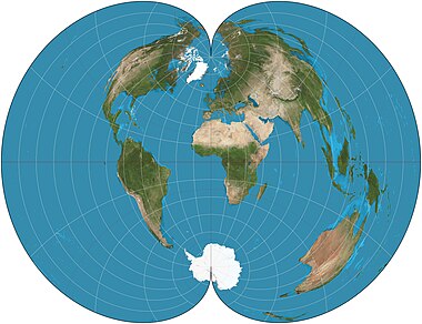
conceptualized as "rolling" a separate cone tangent to the Earth at each parallel of latitude, rather than a single cone as in a normal conic projection. Each parallel is a circular arc of true scale. The scale is also true on the central meridian of the projection. This projection was in common use
110:
90:
32:
27:
60:
54:
94:
78:
44:
39:
68:
73:
104:
17:
77:
by many map-making agencies of the United States from the time of its proposal by
84:
25:
8:
111:Knowledge (XXG) Picture of the day July 2016
7:
81:in 1825 until the mid-20th century.
24:
59:
1:
69:American Polyconic projection
28:Picture of the day archives
127:
95:More featured pictures...
79:Ferdinand Rudolph Hassler
55:Picture of the day
88:
118:
82:
63:
49:
38:
30:
126:
125:
121:
120:
119:
117:
116:
115:
101:
100:
99:
98:
97:
87:, using Geocart
64:
57:
51:
50:
47:
42:
36:
26:
22:
21:
20:
12:
11:
5:
124:
122:
114:
113:
103:
102:
89:
74:map projection
65:
58:
53:
52:
43:
35:
23:
15:
14:
13:
10:
9:
6:
4:
3:
2:
123:
112:
109:
108:
106:
96:
92:
86:
80:
75:
71:
70:
62:
56:
46:
41:
34:
29:
19:
18:Template:POTD
67:
45:2016 July 9
40:2016 July 7
33:2016 July
105:Category
91:Archive
85:Strebe
83:Map:
72:is a
16:<
66:The
48:>
37:<
107::
93:–
31::
Text is available under the Creative Commons Attribution-ShareAlike License. Additional terms may apply.