69:
1002:
105:
141:
45:
216:
234:
148:
112:
76:
676:
606:
Of the 602 households, 49.8% had children under the age of 18; 79.6% were married couples living together; 3.8% had a female householder with no husband present and 14.6% were non-families. Of all households, 10.1% were made up of individuals and 3.2% had someone living alone who was 65 years of age
610:
29.4% of the population were under the age of 18, 3.5% from 18 to 24, 33.9% from 25 to 44, 24.9% from 45 to 64, and 8.3% who were 65 years of age or older. The median age was 37.0 years. For every 100 females, the population had 105.3 males. For every 100 females ages 18 and older there were 103.2
480:. Most of the area consists of less densely-spaced single family homes throughout and commercial establishments along Route 27. The remainder of the area is forested and hilly as the terrain descends towards the
1399:
1409:
449:, Ten Mile Run had a total area of 2.539 square miles (6.576 km), including 2.538 square miles (6.573 km) of land and 0.001 square miles (0.002 km) of water (0.04%).
885:
68:
717:
751:
GCT-PH1 - Population, Housing Units, Area, and
Density: 2010 - County -- County Subdivision and Place from the 2010 Census Summary File 1 for Somerset County, New Jersey
1404:
1041:
596:
418:
263:
575:
was 771.9 per square mile (298.0/km). There were 622 housing units at an average density of 245.1 per square mile (94.6/km). The racial makeup was 31.85% (624)
753:
44:
878:
176:
104:
382:
140:
1296:
871:
701:
394:
1051:
1046:
1036:
815:
DP-1 - Profile of
General Population and Housing Characteristics: 2010 Demographic Profile Data for Ten Mile Run CDP, New Jersey
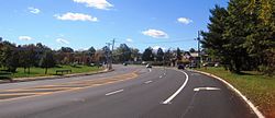
1056:
863:
1276:
1169:
1109:
592:
410:
246:
1316:
1026:
986:
966:
659:
584:
469:
54:
1301:
1209:
1094:
1084:
961:
477:
750:
1215:
1144:
1129:
1104:
1061:
895:
818:
793:
777:
761:
663:
638:
473:
446:
422:
251:
89:
1256:
1184:
1124:
481:
814:
634:
1369:
1149:
1119:
1079:
936:
568:
541:
526:
453:
434:
1336:
1326:
1231:
1225:
1194:
489:
366:
208:
697:
1321:
1154:
1071:
941:
773:
414:
35:
1341:
1331:
1306:
1291:
1199:
1159:
1099:
1089:
1031:
1021:
981:
976:
917:
840:
600:
375:
371:
1311:
1266:
1251:
1220:
1179:
1164:
1013:
956:
946:
790:
New Jersey: 2010 - Population and
Housing Unit Counts - 2010 Census of Population and Housing (CPH-2-32)
358:
258:
1376:
1241:
1236:
1204:
1174:
1139:
1134:
991:
951:
928:
347:
971:
830:
Geological Survey of New Jersey. "Annual Report of the State
Geologist of New Jersey." s.n., 1882
588:
580:
576:
461:
50:
492:, the CDP located on the South Brunswick side of Route 27, consists of more densely-spaced homes.
1286:
1261:
572:
698:
U.S. Geological Survey
Geographic Names Information System: Ten Mile Run Census Designated Place
1189:
1114:
337:
1346:
738:
457:
387:
485:
465:
354:
333:
1393:
757:
607:
or older. The average household size was 3.25 and the average family size was 3.53.
789:
910:
845:
430:
426:
239:
226:
125:
191:
178:
328:
1360:‡This populated place also has portions in an adjacent county or counties
712:
710:
571:
counted 1,959 people, 602 households, and 514 families in the CDP. The
1001:
867:
1000:
774:
2006-2010 American
Community Survey Geography for New Jersey
1400:
Census-designated places in
Somerset County, New Jersey
741:, Missouri Census Data Center. Accessed June 9, 2023.
21:
Census-designated place in New Jersey, United States
1355:
1275:
1070:
1012:
927:
393:
381:
365:
344:
327:
319:
311:
306:
298:
290:
282:
274:
269:
257:
245:
225:
207:
26:
16:Populated place in Somerset County, New Jersey, US
603:of any race were 6.33% (124) of the population.
49:Location of Ten Mile Run at the intersection of
294:0.00 sq mi (0.00 km) 0.04%
1410:Franklin Township, Somerset County, New Jersey
1005:Map of New Jersey highlighting Somerset County
879:
810:
808:
806:
804:
802:
8:
630:
628:
626:
624:
886:
872:
864:
796:, August 2012. Accessed February 11, 2013.
499:
452:The area is named for the Ten Mile Run, a
23:
599:, and 3.32% (65) from two or more races.
660:US Gazetteer files: 2010, 2000, and 1990
620:
456:the hill on which it sits (part of the
380:
364:
326:
305:
297:
268:
206:
171:
94:Show map of Somerset County, New Jersey
60:
41:
1405:Census-designated places in New Jersey
739:Geographic Codes Lookup for New Jersey
519:
655:
653:
651:
649:
647:
472:. It is located across Route 27 from
392:
343:
318:
310:
289:
281:
273:
256:
244:
224:
7:
147:
111:
75:
841:"Aerial view of Ten Mile Run (CDP)"
702:Geographic Names Information System
286:2.54 sq mi (6.58 km)
278:2.54 sq mi (6.58 km)
894:Municipalities and communities of
509:
437:, the CDP's population was 1,959.
14:
677:"ArcGIS REST Services Directory"
232:
214:
146:
139:
110:
103:
74:
67:
43:
635:Gazetteer of New Jersey Places
1:
821:. Accessed February 11, 2013.
780:. Accessed February 11, 2013.
764:. Accessed February 11, 2013.
720:. United States Census Bureau
679:. United States Census Bureau
666:. Accessed September 4, 2014.
468:) near its intersection with
460:). The area is located along
323:809.37/sq mi (312.50/km)
163:Show map of the United States
160:Location in the United States
897:Somerset County, New Jersey
819:United States Census Bureau
794:United States Census Bureau
778:United States Census Bureau
762:United States Census Bureau
704:. Accessed August 23, 2012.
664:United States Census Bureau
639:United States Census Bureau
447:United States Census Bureau
1426:
482:Delaware and Raritan Canal
1365:
998:
908:
641:. Accessed July 21, 2016.
581:Black or African American
569:2010 United States census
555:
540:
525:
518:
513:
508:
505:
435:2010 United States Census
172:
61:
42:
33:
556:Population sources: 2010
411:unincorporated community
28:Ten Mile Run, New Jersey
718:"Census Population API"
454:stream of the same name
415:census-designated place
302:213 ft (65 m)
192:40.424136°N 74.586348°W
36:Census-designated place
1006:
130:Show map of New Jersey
1004:
501:Historical population
346: • Summer (
197:40.424136; -74.586348
1378:United States portal
320: • Density
502:
188: /
1110:Bridgewater Center
1007:
601:Hispanic or Latino
595:, 2.30% (45) from
573:population density
500:
312: • Total
291: • Water
275: • Total
1387:
1386:
1371:New Jersey portal
1317:Little Rocky Hill
987:South Bound Brook
967:Peapack-Gladstone
560:
559:
445:According to the
419:Franklin Township
417:(CDP) located in
404:
403:
283: • Land
1417:
1379:
1372:
1302:Franklin Corners
1210:Neshanic Station
1095:Blackwells Mills
1003:
962:North Plainfield
920:
913:
903:
898:
888:
881:
874:
865:
858:
857:
855:
853:
837:
831:
828:
822:
812:
797:
787:
781:
771:
765:
748:
742:
736:
730:
729:
727:
725:
714:
705:
695:
689:
688:
686:
684:
673:
667:
657:
642:
632:
593:Pacific Islander
521:
516:
511:
503:
478:Middlesex County
470:County Route 518
458:Rocky Hill Ridge
351:
238:
236:
235:
220:
218:
217:
203:
202:
200:
199:
198:
193:
189:
186:
185:
184:
181:
164:
150:
149:
143:
131:
114:
113:
107:
95:
78:
77:
71:
47:
24:
1425:
1424:
1420:
1419:
1418:
1416:
1415:
1414:
1390:
1389:
1388:
1383:
1377:
1370:
1361:
1351:
1278:
1271:
1216:Pleasant Plains
1145:Franklin Center
1130:East Rocky Hill
1105:Bradley Gardens
1066:
1008:
996:
923:
918:
911:
904:
901:
896:
892:
862:
861:
851:
849:
839:
838:
834:
829:
825:
813:
800:
788:
784:
772:
768:
749:
745:
737:
733:
723:
721:
716:
715:
708:
696:
692:
682:
680:
675:
674:
670:
658:
645:
633:
622:
617:
587:, 50.54% (990)
585:Native American
579:, 11.94% (234)
565:
514:
498:
486:Millstone River
474:South Brunswick
466:Lincoln Highway
443:
423:Somerset County
345:
233:
231:
215:
213:
196:
194:
190:
187:
182:
179:
177:
175:
174:
168:
167:
166:
165:
162:
161:
158:
157:
156:
155:
151:
134:
133:
132:
129:
128:
122:
121:
120:
119:
115:
98:
97:
96:
93:
92:
90:Somerset County
86:
85:
84:
83:
79:
57:
38:
29:
22:
17:
12:
11:
5:
1423:
1421:
1413:
1412:
1407:
1402:
1392:
1391:
1385:
1384:
1382:
1381:
1374:
1366:
1363:
1362:
1359:
1357:
1353:
1352:
1350:
1349:
1344:
1339:
1334:
1329:
1324:
1319:
1314:
1309:
1304:
1299:
1294:
1289:
1283:
1281:
1273:
1272:
1270:
1269:
1264:
1259:
1254:
1249:
1244:
1239:
1234:
1229:
1223:
1218:
1213:
1207:
1202:
1197:
1192:
1187:
1185:Liberty Corner
1182:
1177:
1172:
1167:
1162:
1157:
1152:
1147:
1142:
1137:
1132:
1127:
1125:East Millstone
1122:
1117:
1112:
1107:
1102:
1097:
1092:
1087:
1082:
1076:
1074:
1068:
1067:
1065:
1064:
1059:
1054:
1049:
1044:
1039:
1034:
1029:
1024:
1018:
1016:
1010:
1009:
999:
997:
995:
994:
989:
984:
979:
974:
969:
964:
959:
954:
949:
944:
939:
933:
931:
925:
924:
909:
906:
905:
893:
891:
890:
883:
876:
868:
860:
859:
832:
823:
798:
782:
766:
756:2020-02-12 at
743:
731:
706:
690:
668:
643:
619:
618:
616:
613:
564:
561:
558:
557:
553:
552:
549:
547:
544:
538:
537:
534:
532:
529:
523:
522:
517:
512:
507:
497:
494:
442:
439:
402:
401:
398:
391:
390:
385:
379:
378:
369:
363:
362:
352:
342:
341:
331:
325:
324:
321:
317:
316:
313:
309:
308:
304:
303:
300:
296:
295:
292:
288:
287:
284:
280:
279:
276:
272:
271:
267:
266:
261:
255:
254:
249:
243:
242:
229:
223:
222:
211:
205:
204:
170:
169:
159:
153:
152:
145:
144:
138:
137:
136:
135:
123:
117:
116:
109:
108:
102:
101:
100:
99:
87:
81:
80:
73:
72:
66:
65:
64:
63:
62:
59:
58:
48:
40:
39:
34:
31:
30:
27:
20:
15:
13:
10:
9:
6:
4:
3:
2:
1422:
1411:
1408:
1406:
1403:
1401:
1398:
1397:
1395:
1380:
1375:
1373:
1368:
1367:
1364:
1358:
1354:
1348:
1345:
1343:
1340:
1338:
1335:
1333:
1330:
1328:
1325:
1323:
1320:
1318:
1315:
1313:
1310:
1308:
1305:
1303:
1300:
1298:
1295:
1293:
1290:
1288:
1285:
1284:
1282:
1280:
1274:
1268:
1265:
1263:
1260:
1258:
1255:
1253:
1250:
1248:
1245:
1243:
1240:
1238:
1235:
1233:
1230:
1227:
1224:
1222:
1219:
1217:
1214:
1211:
1208:
1206:
1203:
1201:
1198:
1196:
1193:
1191:
1188:
1186:
1183:
1181:
1178:
1176:
1173:
1171:
1168:
1166:
1163:
1161:
1158:
1156:
1153:
1151:
1150:Franklin Park
1148:
1146:
1143:
1141:
1138:
1136:
1133:
1131:
1128:
1126:
1123:
1121:
1120:East Franklin
1118:
1116:
1113:
1111:
1108:
1106:
1103:
1101:
1098:
1096:
1093:
1091:
1088:
1086:
1083:
1081:
1080:Basking Ridge
1078:
1077:
1075:
1073:
1069:
1063:
1060:
1058:
1055:
1053:
1050:
1048:
1045:
1043:
1040:
1038:
1035:
1033:
1030:
1028:
1025:
1023:
1020:
1019:
1017:
1015:
1011:
993:
990:
988:
985:
983:
980:
978:
975:
973:
970:
968:
965:
963:
960:
958:
955:
953:
950:
948:
945:
943:
940:
938:
937:Bernardsville
935:
934:
932:
930:
926:
922:
921:
914:
907:
902:United States
899:
889:
884:
882:
877:
875:
870:
869:
866:
848:
847:
842:
836:
833:
827:
824:
820:
816:
811:
809:
807:
805:
803:
799:
795:
791:
786:
783:
779:
775:
770:
767:
763:
759:
758:archive.today
755:
752:
747:
744:
740:
735:
732:
719:
713:
711:
707:
703:
699:
694:
691:
678:
672:
669:
665:
661:
656:
654:
652:
650:
648:
644:
640:
636:
631:
629:
627:
625:
621:
614:
612:
608:
604:
602:
598:
594:
590:
586:
582:
578:
574:
570:
562:
554:
550:
548:
545:
543:
539:
535:
533:
530:
528:
524:
504:
495:
493:
491:
487:
483:
479:
475:
471:
467:
463:
459:
455:
450:
448:
440:
438:
436:
432:
428:
424:
420:
416:
412:
408:
399:
396:
389:
386:
384:
377:
373:
370:
368:
360:
359:Eastern (EDT)
356:
353:
349:
339:
338:Eastern (EST)
335:
332:
330:
322:
314:
301:
293:
285:
277:
265:
262:
260:
253:
250:
248:
241:
230:
228:
221:United States
212:
210:
201:
173:Coordinates:
142:
127:
106:
91:
70:
56:
52:
46:
37:
32:
25:
19:
1337:South Branch
1327:North Branch
1247:Ten Mile Run
1246:
1232:Six Mile Run
1226:Pottersville
1195:Martinsville
1170:Hillsborough
1052:Hillsborough
916:
850:. Retrieved
844:
835:
826:
785:
769:
746:
734:
722:. Retrieved
693:
681:. Retrieved
671:
609:
605:
591:, 0.00% (0)
583:, 0.05% (1)
566:
496:Demographics
490:Kendall Park
451:
444:
433:. As of the
407:Ten Mile Run
406:
405:
367:Area code(s)
154:Ten Mile Run
124:Location in
118:Ten Mile Run
88:Location in
82:Ten Mile Run
18:
1322:Middlebrook
1279:communities
1155:Green Knoll
1047:Green Brook
1037:Bridgewater
942:Bound Brook
912:County seat
852:October 21,
846:Google Maps
724:October 11,
683:October 11,
597:other races
563:2010 census
195: /
1394:Categories
1342:Stoutsburg
1332:Rockingham
1307:Free Acres
1292:Cloverhill
1200:Middlebush
1160:Griggstown
1100:Blawenburg
1090:Belle Mead
1085:Bedminster
1057:Montgomery
1032:Branchburg
1022:Bedminster
982:Somerville
977:Rocky Hill
919:Somerville
615:References
431:New Jersey
427:U.S. state
397:feature ID
307:Population
240:New Jersey
183:74°35′11″W
180:40°25′27″N
126:New Jersey
1356:Footnotes
1312:Gladstone
1297:Dutchtown
1267:Zarephath
1252:The Hills
1221:Pluckemin
1180:Lamington
1165:Harlingen
1014:Townships
957:Millstone
947:Far Hills
441:Geography
425:, in the
383:FIPS code
355:UTC−04:00
334:UTC−05:00
329:Time zone
299:Elevation
1257:Voorhees
1242:Somerset
1237:Skillman
1205:Neshanic
1175:Kingston
1140:Flagtown
1135:Finderne
1042:Franklin
1027:Bernards
992:Watchung
952:Manville
929:Boroughs
754:Archived
462:Route 27
400:02584033
388:34-72435
264:Franklin
259:Township
252:Somerset
51:Route 27
972:Raritan
843:(Map).
611:males.
376:732/848
372:609/640
209:Country
1287:Amwell
1262:Weston
1062:Warren
506:Census
409:is an
247:County
237:
219:
55:CR 518
1277:Other
1190:Lyons
1115:Clyde
589:Asian
577:White
546:2,055
531:1,959
421:, in
315:2,055
227:State
1347:Zion
1072:CDPs
854:2015
726:2022
685:2022
567:The
551:4.9%
542:2020
527:2010
515:Note
510:Pop.
484:and
413:and
395:GNIS
374:and
270:Area
53:and
429:of
348:DST
1396::
915::
900:,
817:,
801:^
792:,
776:,
760:,
709:^
700:,
662:,
646:^
637:,
623:^
520:%±
488:.
476:,
1228:‡
1212:‡
887:e
880:t
873:v
856:.
728:.
687:.
536:—
464:(
361:)
357:(
350:)
340:)
336:(
Text is available under the Creative Commons Attribution-ShareAlike License. Additional terms may apply.