102:
114:
126:
78:
586:
28:
20:
138:
90:
54:
that ran aground near here on March 6, 1853. All 550 passengers climbed safely onto the beach, and fourteen chests of gold were salvaged before the ship broke up. Remnants of the ship can still be seen during low tide during some winter days on the south end of the beach.
101:
113:
676:
661:
627:
666:
161:
547:
656:
125:
77:
490:
620:
389:
66:
On
December 29, 2012, the landmark arch at Tennessee Cove collapsed. The landmark had been a popular photography subject over the years.
651:
298:
250:
434:
523:
283:
187:
613:
323:
515:
429:
510:
646:
137:
293:
328:
593:
495:
399:
278:
212:
43:
172:
243:
469:
308:
585:
288:
89:
58:
The cove is a 1.7-mile (2.7 km) hike from the parking lot near the end of
Tennessee Valley Road.
349:
303:
671:
528:
333:
313:
273:
533:
236:
409:
374:
318:
27:
19:
597:
369:
191:
364:
354:
640:
505:
474:
404:
384:
359:
39:
449:
419:
414:
464:
439:
424:
454:
444:
379:
259:
562:
549:
394:
173:
U.S. Geological Survey
Geographic Names Information System: Tennessee Valley
51:
26:
18:
500:
107:
A raven stands on a fence post along the
Tennessee Valley trail.
232:
228:
23:
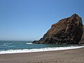
Tennessee Cove, 2012 (arch no longer present as of 2013)
601:
213:"Tennessee Beach Arch In Marin Crashes To The Ground"
119:
People walking on
Tennessee Valley trail to the beach
483:
342:
266:
621:
244:
182:
180:
8:
628:
614:
251:
237:
229:
16:Embankment in Marin County, California, US
677:Marin County, California geography stubs
188:"Golden Gate National Parks Conservancy"
662:Landforms of the San Francisco Bay Area
154:
73:
491:Bolinas-Stinson Union School District
7:
582:
580:
390:Golden Gate National Recreation Area
667:History of Marin County, California
131:Tennessee Valley trail to the beach
600:. You can help Knowledge (XXG) by
435:Rancho Punta de los Reyes Sobrante
14:
524:Shoreline Unified School District
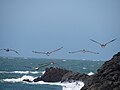
83:Pelicans fly over Tennessee Cove.
657:Bays of Marin County, California
584:
136:
124:
112:
100:
88:
76:
1:
430:Point Reyes National Seashore
46:. It is named after the S.S.
511:North Pacific Coast Railroad
693:
652:Coves of the United States
579:
38:is an embankment off the
594:Marin County, California
563:37.840483°N 122.551643°W
496:California State Route 1
44:Marin County, California
596:–related article is a
568:37.840483; -122.551643
470:Tomales Bay State Park
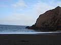
143:Tennessee Cove in 2021
32:
31:Tennessee Valley Beach
24:
30:
22:
350:Audubon Canyon Ranch
559: /
529:Tomales High School
343:Geography and parks
324:Point Reyes Station
194:on December 3, 2008
647:Bays of California
534:West Marin Citizen
33:
25:
609:
608:
542:
541:
518:Point Reyes Light
410:Nicasio Reservoir
375:Copper Mine Gulch
684:
630:
623:
616:
588:
581:
574:
573:
571:
570:
569:
564:
560:
557:
556:
555:
552:
253:
246:
239:
230:
223:
222:
220:
219:
209:
203:
202:
200:
199:
190:. Archived from
184:
175:
170:
164:
159:
140:
128:
116:
104:
92:
80:
692:
691:
687:
686:
685:
683:
682:
681:
637:
636:
635:
634:
577:
567:
565:
561:
558:
553:
550:
548:
546:
545:
543:
538:
479:
370:Centissima Reef
338:
262:
257:
227:
226:
217:
215:
211:
210:
206:
197:
195:
186:
185:
178:
171:
167:
160:
156:
151:
144:
141:
132:
129:
120:
117:
108:
105:
96:
93:
84:
81:
72:
64:
17:
12:
11:
5:
690:
688:
680:
679:
674:
669:
664:
659:
654:
649:
639:
638:
633:
632:
625:
618:
610:
607:
606:
589:
540:
539:
537:
536:
531:
526:
521:
513:
508:
503:
498:
493:
487:
485:
481:
480:
478:
477:
472:
467:
462:
460:Tennessee Cove
457:
452:
447:
442:
437:
432:
427:
422:
417:
412:
407:
402:
397:
392:
387:
382:
377:
372:
367:
365:Bonita Channel
362:
357:
355:Bolinas Lagoon
352:
346:
344:
340:
339:
337:
336:
331:
326:
321:
316:
311:
306:
301:
296:
294:Inverness Park
291:
286:
281:
276:
270:
268:
264:
263:
258:
256:
255:
248:
241:
233:
225:
224:
204:
176:
165:
153:
152:
150:
147:
146:
145:
142:
135:
133:
130:
123:
121:
118:
111:
109:
106:
99:
97:
95:Tennessee Cove
94:
87:
85:
82:
75:
71:
68:
63:
60:
36:Tennessee Cove
15:
13:
10:
9:
6:
4:
3:
2:
689:
678:
675:
673:
670:
668:
665:
663:
660:
658:
655:
653:
650:
648:
645:
644:
642:
631:
626:
624:
619:
617:
612:
611:
605:
603:
599:
595:
590:
587:
583:
578:
575:
572:
535:
532:
530:
527:
525:
522:
520:
519:
514:
512:
509:
507:
506:Marin Organic
504:
502:
499:
497:
494:
492:
489:
488:
486:
482:
476:
475:Tomales Point
473:
471:
468:
466:
463:
461:
458:
456:
453:
451:
448:
446:
443:
441:
438:
436:
433:
431:
428:
426:
423:
421:
418:
416:
413:
411:
408:
406:
405:Nicasio Creek
403:
401:
398:
396:
393:
391:
388:
386:
385:Drakes Estero
383:
381:
378:
376:
373:
371:
368:
366:
363:
361:
360:Bolinas Ridge
358:
356:
353:
351:
348:
347:
345:
341:
335:
332:
330:
329:Stinson Beach
327:
325:
322:
320:
317:
315:
312:
310:
307:
305:
302:
300:
297:
295:
292:
290:
287:
285:
282:
280:
277:
275:
272:
271:
269:
265:
261:
254:
249:
247:
242:
240:
235:
234:
231:
214:
208:
205:
193:
189:
183:
181:
177:
174:
169:
166:
163:
158:
155:
148:
139:
134:
127:
122:
115:
110:
103:
98:
91:
86:
79:
74:
69:
67:
61:
59:
56:
53:
49:
45:
41:
40:Pacific Ocean
37:
29:
21:
602:expanding it
591:
576:
544:
517:
459:
450:Rodeo Lagoon
420:Pirates Cove
415:Olema Valley
279:Dillon Beach
216:. Retrieved
207:
196:. Retrieved
192:the original
168:
157:
65:
57:
47:
35:
34:
566: /
554:122°33′06″W
465:Tomales Bay
440:Rodeo Beach
425:Point Reyes
400:Kent Island
672:West Marin
641:Categories
551:37°50′26″N
455:Sears Rock
445:Rodeo Cove
380:Drakes Bay
309:Muir Beach
260:West Marin
218:2014-11-16
198:2009-07-30
149:References
484:Community
395:Gull Rock
299:Lagunitas
289:Inverness
62:Landmarks
52:steamship
48:Tennessee
304:Marshall
267:Villages
334:Tomales
314:Nicasio
284:Dogtown
274:Bolinas
70:Gallery
592:This
319:Olema
598:stub
516:The
501:KWMR
162:USGS
50:, a
42:in
643::
179:^
629:e
622:t
615:v
604:.
252:e
245:t
238:v
221:.
201:.
Text is available under the Creative Commons Attribution-ShareAlike License. Additional terms may apply.