112:
810:
96:
81:
695:
71:
56:
651:
1396:
759:
119:
485:). The average annual temperature in Tenryū is 13.3 °C. The average annual rainfall is 1964 mm with September as the wettest month. The temperatures are highest on average in August, at around 25.1 °C, and lowest in January, at around 1.9 °C.
347:
634:
Tenryū has one public elementary school and one public middle school operated by the village government, and one private elementary school and one private middle school. The village does not have a high school.
111:
143:
1433:
809:
95:
1457:
827:
1377:
799:
479:
80:
1462:
991:
1426:
1294:
1151:
654:
777:
1361:
1242:
1060:
1306:
1185:
962:
55:
1452:
1366:
1136:
1082:
979:
1222:
1163:
763:
219:
1419:
1023:
698:
675:
185:
175:
194:
70:
626:. The village was established on September 30, 1956 by the merger of the villages of Hiraoka and Kamihara.
395:
of 12.1 persons per km. The total area of the village is 109.44 square kilometres (42.26 sq mi).
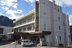
1119:
1328:
837:
792:
663:
202:
1109:
465:
460:
408:
269:
1311:
1210:
1205:
667:
392:
214:
731:
493:
Per
Japanese census data, the population of Tenryū has dropped rapidly over the past 70 years.
1252:
1178:
1168:
916:
850:
813:
679:
380:
376:
207:
46:
1267:
1190:
1129:
1092:
1048:
1016:
926:
896:
623:
448:
404:
16:
This article is about village on Nagano
Prefecture. For the adjacent ward of Hamamatsu, see
1287:
1277:
1070:
1053:
871:
785:
441:
941:
412:
190:
1403:
1338:
1262:
1237:
1215:
1173:
1038:
1028:
984:
972:
936:
906:
901:
886:
298:
17:
1446:
1299:
1200:
1156:
1141:
1099:
1075:
996:
911:
876:
845:
822:
742:
671:
453:
1333:
1247:
1232:
1227:
1033:
967:
946:
931:
921:
881:
436:
431:
403:
Tenryū is located in mountainous far south of Nagano
Prefecture on its border with
288:
478:
The town has a climate characterized by hot and humid summers, and cold winters (
1321:
1316:
1011:
891:
650:
416:
1395:
1257:
388:
308:
415:
runs through the village, which is over 90% covered in mountains and forest.
158:
145:
1343:
1001:
658:
346:
260:
758:
1195:
1124:
1104:
1006:
866:
350:
1146:
1114:
1065:
1043:
265:
1282:
1087:
384:
345:
510:
781:
769:
387:. As of 1 April 2019, the village had an estimated
336:
717:
505:
326:
878 Hiraoka Tenryū-mura, Shimoina-gun, Nagano-ken 399-1201
1407:
1354:
955:
859:
836:
622:The area of present-day Tenryū was part of ancient
330:
322:
314:
304:
294:
284:
276:
259:
251:
243:
238:
230:
225:
213:
201:
184:
174:
28:
368:
362:
34:
1427:
1402:This Nagano Prefecture location article is a
793:
8:
496:
1434:
1420:
800:
786:
778:
495:
25:
710:
329:
313:
275:
258:
237:
224:
173:
138:
104:
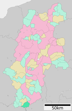
100:Location of Tenryū in Nagano Prefecture
92:
64:
52:
234:109.44 km (42.26 sq mi)
321:
303:
293:
283:
250:
242:
229:
212:
200:
183:
7:
1392:
1390:
1378:List of mergers in Nagano Prefecture
718:Tenryū Village official statistocs
391:of 1,275 in 712 households, and a
14:
1394:
808:
757:
693:
649:
117:
110:
94:
79:
69:
54:
118:
1:
1458:Villages in Nagano Prefecture
480:Köppen climate classification
353:, a local specialty of Tenryū
1406:. You can help Knowledge by
743:Tenryū population statistics
369:
1479:
1389:
423:Surrounding municipalities
419:is located within Tenryū.
15:
1375:
820:
523:—
363:
139:
105:
93:
65:
53:
44:
35:
159:35.276361°N 137.854222°E
32:
992:Higashichikuma District
699:National Route 418
23:Village in Chūbu, Japan
1463:Nagano geography stubs
354:
1295:Shimominochi District
497:Historical population
349:
255:12/km (30/sq mi)
164:35.276361; 137.854222
1362:Minamiazumi District
1061:Kamiminochi District
766:at Wikimedia Commons
252: • Density
1307:Shimotakai District
1186:Minamisaku District
963:Chiisagata District
732:Tenryū climate data
498:
461:Shizuoka Prefecture
409:Shizuoka Prefecture
270:Japan Standard Time
155: /
60:Tenryū Village Hall
1367:Sarashina District
1137:Kitaazumi District
1083:Kamitakai District
980:Hanishina District
428:Nagano Prefecture
393:population density
355:
244: • Total
231: • Total
1415:
1414:
1384:
1383:
1223:Shimoina District
1164:Kitasaku District
814:Nagano Prefecture
762:Media related to
615:
614:
381:Nagano Prefecture
344:
343:
315:Phone number
1470:
1436:
1429:
1422:
1398:
1391:
1355:Former Districts
1024:Kamiina District
831:
812:
802:
795:
788:
779:
774:
770:Official Website
761:
745:
740:
734:
729:
723:
722:
715:
697:
696:
653:
624:Shinano Province
512:
507:
499:
449:Aichi Prefecture
405:Aichi Prefecture
374:
372:
366:
365:
340:
339:
337:Official website
170:
169:
167:
166:
165:
160:
156:
153:
152:
151:
148:
121:
120:
114:
98:
83:
73:
58:
39:
38:
37:
26:
1478:
1477:
1473:
1472:
1471:
1469:
1468:
1467:
1443:
1442:
1441:
1440:
1387:
1385:
1380:
1371:
1350:
951:
855:
832:
825:
816:
806:
772:
754:
749:
748:
741:
737:
730:
726:
720:
716:
712:
707:
694:
690:
646:
641:
632:
620:
491:
476:
425:
401:
360:
335:
334:
163:
161:
157:
154:
149:
146:
144:
142:
141:
135:
134:
133:
132:
129:
128:
127:
126:
122:
101:
89:
88:
87:
86:
77:
76:
61:
49:
40:
33:
31:
24:
21:
12:
11:
5:
1476:
1474:
1466:
1465:
1460:
1455:
1453:Tenryū, Nagano
1445:
1444:
1439:
1438:
1431:
1424:
1416:
1413:
1412:
1399:
1382:
1381:
1376:
1373:
1372:
1370:
1369:
1364:
1358:
1356:
1352:
1351:
1349:
1348:
1347:
1346:
1341:
1336:
1326:
1325:
1324:
1319:
1314:
1304:
1303:
1302:
1292:
1291:
1290:
1285:
1280:
1275:
1270:
1265:
1260:
1255:
1250:
1245:
1240:
1235:
1230:
1220:
1219:
1218:
1213:
1208:
1203:
1198:
1193:
1183:
1182:
1181:
1176:
1171:
1161:
1160:
1159:
1154:
1149:
1144:
1134:
1133:
1132:
1127:
1122:
1120:Kiso (village)
1117:
1112:
1107:
1097:
1096:
1095:
1090:
1080:
1079:
1078:
1073:
1068:
1058:
1057:
1056:
1051:
1046:
1041:
1036:
1031:
1021:
1020:
1019:
1014:
1009:
1004:
999:
989:
988:
987:
977:
976:
975:
970:
959:
957:
953:
952:
950:
949:
944:
939:
934:
929:
924:
919:
914:
909:
904:
899:
894:
889:
884:
879:
874:
869:
863:
861:
857:
856:
854:
853:
848:
842:
840:
834:
833:
821:
818:
817:
807:
805:
804:
797:
790:
782:
776:
775:
767:
764:Tenryū, Nagano
753:
752:External links
750:
747:
746:
735:
724:
709:
708:
706:
703:
702:
701:
689:
686:
685:
684:
683:
682:
645:
642:
640:
639:Transportation
637:
631:
628:
619:
616:
613:
612:
609:
606:
602:
601:
598:
595:
591:
590:
587:
584:
580:
579:
576:
573:
569:
568:
565:
562:
558:
557:
554:
551:
547:
546:
543:
540:
536:
535:
532:
529:
525:
524:
521:
518:
514:
513:
508:
503:
490:
487:
475:
472:
471:
470:
469:
468:
458:
457:
456:
446:
445:
444:
439:
434:
424:
421:
400:
397:
342:
341:
332:
328:
327:
324:
320:
319:
316:
312:
311:
306:
302:
301:
299:Lilium auratum
296:
292:
291:
286:
282:
281:
278:
274:
273:
263:
257:
256:
253:
249:
248:
245:
241:
240:
236:
235:
232:
228:
227:
223:
222:
217:
211:
210:
205:
199:
198:
188:
182:
181:
178:
172:
171:
137:
136:
130:
124:
123:
116:
115:
109:
108:
107:
106:
103:
102:
99:
91:
90:
84:
78:
74:
68:
67:
66:
63:
62:
59:
51:
50:
45:
42:
41:
29:
22:
13:
10:
9:
6:
4:
3:
2:
1475:
1464:
1461:
1459:
1456:
1454:
1451:
1450:
1448:
1437:
1432:
1430:
1425:
1423:
1418:
1417:
1411:
1409:
1405:
1400:
1397:
1393:
1388:
1379:
1374:
1368:
1365:
1363:
1360:
1359:
1357:
1353:
1345:
1342:
1340:
1337:
1335:
1332:
1331:
1330:
1329:Suwa District
1327:
1323:
1320:
1318:
1315:
1313:
1310:
1309:
1308:
1305:
1301:
1298:
1297:
1296:
1293:
1289:
1286:
1284:
1281:
1279:
1276:
1274:
1271:
1269:
1266:
1264:
1261:
1259:
1256:
1254:
1251:
1249:
1246:
1244:
1241:
1239:
1236:
1234:
1231:
1229:
1226:
1225:
1224:
1221:
1217:
1214:
1212:
1209:
1207:
1204:
1202:
1199:
1197:
1194:
1192:
1189:
1188:
1187:
1184:
1180:
1177:
1175:
1172:
1170:
1167:
1166:
1165:
1162:
1158:
1155:
1153:
1150:
1148:
1145:
1143:
1140:
1139:
1138:
1135:
1131:
1128:
1126:
1123:
1121:
1118:
1116:
1113:
1111:
1108:
1106:
1103:
1102:
1101:
1100:Kiso District
1098:
1094:
1091:
1089:
1086:
1085:
1084:
1081:
1077:
1074:
1072:
1069:
1067:
1064:
1063:
1062:
1059:
1055:
1052:
1050:
1047:
1045:
1042:
1040:
1037:
1035:
1032:
1030:
1027:
1026:
1025:
1022:
1018:
1015:
1013:
1010:
1008:
1005:
1003:
1000:
998:
995:
994:
993:
990:
986:
983:
982:
981:
978:
974:
971:
969:
966:
965:
964:
961:
960:
958:
954:
948:
945:
943:
940:
938:
935:
933:
930:
928:
925:
923:
920:
918:
915:
913:
910:
908:
905:
903:
900:
898:
895:
893:
890:
888:
885:
883:
880:
878:
875:
873:
870:
868:
865:
864:
862:
858:
852:
849:
847:
844:
843:
841:
839:
835:
829:
824:
819:
815:
811:
803:
798:
796:
791:
789:
784:
783:
780:
773:(in Japanese)
771:
768:
765:
760:
756:
755:
751:
744:
739:
736:
733:
728:
725:
721:(in Japanese)
719:
714:
711:
704:
700:
692:
691:
687:
681:
677:
673:
669:
665:
662:
661:
660:
656:
652:
648:
647:
643:
638:
636:
629:
627:
625:
617:
610:
607:
604:
603:
599:
596:
593:
592:
588:
585:
582:
581:
577:
574:
571:
570:
566:
563:
560:
559:
555:
552:
549:
548:
544:
541:
538:
537:
533:
530:
527:
526:
522:
519:
516:
515:
509:
504:
501:
500:
494:
488:
486:
484:
481:
473:
467:
464:
463:
462:
459:
455:
452:
451:
450:
447:
443:
440:
438:
435:
433:
430:
429:
427:
426:
422:
420:
418:
414:
410:
406:
398:
396:
394:
390:
386:
382:
378:
371:
359:
352:
348:
338:
333:
325:
317:
310:
307:
300:
297:
290:
287:
279:
271:
267:
264:
262:
254:
246:
233:
221:
218:
216:
209:
206:
204:
196:
192:
189:
187:
179:
177:
168:
150:137°51′15.2″E
140:Coordinates:
113:
97:
82:
72:
57:
48:
43:
27:
19:
1408:expanding it
1401:
1386:
1272:
1034:Minamiminowa
738:
727:
713:
664:Nakaisamurai
633:
621:
492:
489:Demographics
482:
477:
413:Tenryū River
402:
357:
356:
318:0260-26-2111
289:Trachycarpus
147:35°16′34.9″N
1322:Nozawaonsen
1317:Kijimadaira
1110:Kiso (town)
838:Core cities
417:Hiraoka Dam
379:located in
370:Tenryū-mura
195:Kōshin'etsu
162: /
18:Tenryū Ward
1447:Categories
1312:Yamanouchi
1211:Minamimaki
1206:Minamiaiki
705:References
668:Ina-Kozawa
389:population
309:Dollarbird
239:Population
203:Prefecture
1344:Shimosuwa
1243:Matsukawa
1179:Tateshina
1169:Karuizawa
1152:Matsukawa
1002:Chikuhoku
956:Districts
851:Matsumoto
680:Shiteguri
659:Iida Line
630:Education
466:Hamamatsu
399:Geography
261:Time zone
1268:Takamori
1196:Kitaaiki
1191:Kawakami
1105:Agematsu
1093:Takayama
1049:Nakagawa
1017:Yamagata
927:Shiojiri
897:Komagane
655:JR Tōkai
295:• Flower
220:Shimoina
215:District
1288:Yasuoka
1278:Toyooka
1258:Shimojō
1071:Shinano
1054:Tatsuno
1007:Ikusaka
872:Chikuma
867:Azumino
828:capital
688:Highway
676:Hiraoka
644:Railway
618:History
474:Climate
442:Yasuoka
377:village
351:Yubeshi
331:Website
323:Address
277:Symbols
176:Country
47:Village
1339:Fujimi
1273:Tenryū
1263:Takagi
1253:Ōshika
1238:Hiraya
1216:Sakuho
1174:Miyota
1147:Hakuba
1115:Nagiso
1066:Iizuna
1044:Miyada
1039:Minowa
1029:Iijima
985:Sakaki
973:Nagawa
937:Suzaka
917:Ōmachi
907:Nakano
902:Komoro
887:Iiyama
860:Cities
846:Nagano
823:Nagano
611:−28.9%
600:−26.0%
589:−20.7%
578:−16.7%
567:−19.7%
556:−27.1%
545:−30.5%
534:+44.7%
454:Toyone
411:. The
358:Tenryū
305:• Bird
285:• Tree
280:
208:Nagano
186:Region
131:
125:Tenryū
30:Tenryū
1300:Sakae
1283:Urugi
1201:Koumi
1157:Otari
1142:Ikeda
1130:Ōtaki
1125:Ōkuwa
1088:Obuse
1076:Ogawa
997:Asahi
912:Okaya
877:Chino
672:Ugusu
608:1,178
605:2020
597:1,657
594:2010
586:2,239
583:2000
575:2,822
572:1990
564:3,389
561:1980
553:4,222
550:1970
542:5,792
539:1960
531:8,337
528:1950
520:5,763
517:1940
385:Japan
375:is a
266:UTC+9
247:1,275
191:Chūbu
180:Japan
1404:stub
1334:Hara
1248:Neba
1233:Anan
1228:Achi
968:Aoki
947:Ueda
942:Tōmi
932:Suwa
922:Saku
882:Iida
506:Pop.
502:Year
437:Anan
432:IIda
407:and
226:Area
85:Seal
75:Flag
1012:Omi
892:Ina
483:Cfa
364:天龍村
36:天龍村
1449::
678:-
674:-
670:-
666:-
657:–
511:±%
383:,
367:,
1435:e
1428:t
1421:v
1410:.
830:)
826:(
801:e
794:t
787:v
373:)
361:(
272:)
268:(
197:)
193:(
20:.
Text is available under the Creative Commons Attribution-ShareAlike License. Additional terms may apply.