153:
71:
37:
371:
248:
476:
146:
462:
490:
391:
destination because its easy access and the very interesting panorama which offers on the Aosta Valley mountains. In order to reach the summit a good starting point is the
552:
88:
102:
604:
531:
735:
730:
145:
432:
446:
95:
494:
267:, one of its tributary valleys. The long stretch of the water divide linking towards NW the Testa di Comagna with
400:
298:
from higher mountains, offers a very wide panorama including many of the main summits of the area such as
62:
740:
295:
36:
70:
264:
423:. Winter routes follow more or less the same itineraries used for summertime access to the summit.
416:
392:
272:
83:
370:
600:
546:
247:
530:
Assessorat du tourisme, des sports, du commerce, de l'agriculture et des biens culturels.
228:
512:
475:
189:
724:
404:
299:
268:
396:
467:
344:
335:
307:
294:
basement. The mountain, thanks to its central position in the Aosta Valley and its
287:
275:(1.640 m). In the opposite direction the water divide continues with the saddle of
260:
256:
236:
208:
196:
178:
303:
481:
358:
457:
420:
311:
117:
104:
436:
677:
625:
574:
703:
651:
489:
384:
291:
75:
388:
323:
215:
52:
369:
246:
182:
678:"Comagna (Testa di) anello da Plésod per le miniere di Béchaz"
435:(IGM) official maps of Italy, 1:25.000 and 1:100.000 scale,
328:
415:
The Testa di
Comagna is also a classical destination for
235:) is a 2,106 metres high peak on the Italian side of the
330:) the mountain can be classified in the following way:
286:
Close to the summit of the Testa di
Comagna stands a
652:"Comagna (Testa di) da Sommarèse per il Col de Joux"
441:
Carta dei sentieri e dei rifugi scala 1:50.000 n. 5
419:, considered of medium difficulty. and hiking with
207:
202:
188:
174:
133:
94:
82:
61:
51:
46:
21:
599:(in Italian). Priuli & Verlucca. p. 132.
352:supergroup =Contrafforti valdostani del Monte Rosa
519:(in Italian). Regione autonoma Valle d'Aosta.
8:
551:: CS1 maint: multiple names: authors list (
534:(in French). Région Autonome Vallée d'Aoste
69:
18:
403:. On the contrary reaching the summit by
152:
501:
544:
513:"Navigatore Cartografico SCT (3.14.0)"
597:Atlante Orografico delle Alpi. SOIUSA
564:
562:
507:
505:
7:
704:"Comagna (testa di) dal col zuccore"
279:(1.607 m}) and then rises up to the
626:"Comagna (Testa di) da Col de Joux"
383:The mountain does not have special
575:"Tzucore (Col) giro testa comagna"
355:group = Costiera Tournalin-Zerbion
14:
340:major sector = North Western Alps
488:
474:
460:
151:
144:
67:439 m (1,440 ft)
35:
255:The mountain is located on the
41:Northern slopes of the mountain
395:, but one can also start from
271:touches its lowest point with
1:
433:Military Geographic Institute
447:Istituto Geografico Centrale
349:subsection = Monte Rosa Alps
89:Alpine mountains 2000-2499 m
57:2,106 m (6,909 ft)
757:
532:"Erésaz - Tête de Comagne"
387:interest but is a popular
736:Mountains of Aosta Valley
138:
34:
26:
731:Two-thousanders of Italy
595:Marazzi, Sergio (2005).
118:45.7447217°N 7.7222085°E
407:requires good skills.
375:
252:
78:: Col de Joux (1640 m)
497:at Wikimedia Commons
373:
318:SOIUSA classification
250:
123:45.7447217; 7.7222085
517:geonavsct.partout.it
443:Cervino e Monte Rosa
366:Access to the summit
165:Location in the Alps
114: /
417:Ski mountaineering
376:
253:
47:Highest point
606:978-88-8068-273-8
493:Media related to
290:, sustained by a
259:between the main
221:
220:
16:Mountain in Italy
748:
715:
714:
712:
711:
695:
689:
688:
686:
685:
669:
663:
662:
660:
659:
643:
637:
636:
634:
633:
617:
611:
610:
592:
586:
585:
583:
582:
566:
557:
556:
550:
542:
540:
539:
527:
521:
520:
509:
495:Testa di Comagna
492:
484:
479:
478:
470:
465:
464:
463:
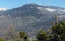
251:View from Rodoz.
225:Testa di Comagna
211:
192:
159:Testa di Comagna
155:
154:
148:
129:
128:
126:
125:
124:
119:
115:
112:
111:
110:
107:
74:
73:
39:
29:
22:Testa di Comagna
19:
756:
755:
751:
750:
749:
747:
746:
745:
721:
720:
719:
718:
709:
707:
697:
696:
692:
683:
681:
671:
670:
666:
657:
655:
645:
644:
640:
631:
629:
619:
618:
614:
607:
594:
593:
589:
580:
578:
568:
567:
560:
543:
537:
535:
529:
528:
524:
511:
510:
503:
480:
473:
466:
461:
459:
456:
437:on-line version
429:
413:
381:
368:
361:= I/B-9.III-B.4
320:
245:
233:Tête de Comagne
209:
190:
170:
169:
168:
167:
166:
163:
162:
161:
160:
156:
122:
120:
116:
113:
108:
105:
103:
101:
100:
68:
42:
30:Tête de Comagne
27:
17:
12:
11:
5:
754:
752:
744:
743:
738:
733:
723:
722:
717:
716:
702:(2008-02-19).
690:
676:(2010-02-18).
664:
650:(2010-02-18).
638:
624:(2013-09-21).
612:
605:
587:
573:(2010-08-30).
558:
522:
500:
499:
486:
485:
471:
455:
452:
451:
450:
439:
428:
425:
412:
409:
380:
377:
367:
364:
363:
362:
356:
353:
350:
347:
341:
338:
319:
316:
244:
241:
219:
218:
213:
205:
204:
200:
199:
194:
186:
185:
176:
172:
171:
164:
158:
157:
150:
149:
143:
142:
141:
140:
139:
136:
135:
131:
130:
98:
92:
91:
86:
80:
79:
65:
59:
58:
55:
49:
48:
44:
43:
40:
32:
31:
24:
23:
15:
13:
10:
9:
6:
4:
3:
2:
753:
742:
739:
737:
734:
732:
729:
728:
726:
705:
701:
694:
691:
679:
675:
668:
665:
653:
649:
642:
639:
627:
623:
616:
613:
608:
602:
598:
591:
588:
576:
572:
565:
563:
559:
554:
548:
533:
526:
523:
518:
514:
508:
506:
502:
498:
496:
491:
483:
477:
472:
469:
458:
453:
448:
444:
440:
438:
434:
431:
430:
426:
424:
422:
418:
410:
408:
406:
405:mountain bike
402:
398:
394:
390:
386:
378:
372:
365:
360:
357:
354:
351:
348:
346:
342:
339:
337:
333:
332:
331:
329:
325:
322:According to
317:
315:
313:
309:
305:
301:
300:Monte Emilius
297:
293:
289:
284:
282:
278:
274:
270:
269:monte Zerbion
266:
262:
258:
249:
242:
240:
238:
234:
230:
226:
217:
214:
212:
210:Easiest route
206:
201:
198:
195:
193:
187:
184:
180:
177:
173:
147:
137:
132:
127:
99:
97:
93:
90:
87:
85:
81:
77:
72:
66:
64:
60:
56:
54:
50:
45:
38:
33:
25:
20:
741:Pennine Alps
708:. Retrieved
706:(in Italian)
699:
693:
682:. Retrieved
680:(in Italian)
673:
667:
656:. Retrieved
654:(in Italian)
647:
641:
630:. Retrieved
628:(in Italian)
621:
615:
596:
590:
579:. Retrieved
577:(in Italian)
570:
536:. Retrieved
525:
516:
487:
468:Italy portal
442:
414:
382:
374:Sumit cross.
345:Pennine Alps
336:Western Alps
334:main part =
327:
321:
308:monte Bianco
288:summit cross
285:
281:Mont d'Arbaz
280:
276:
261:Aosta Valley
257:water divide
254:
237:Pennine Alps
232:
224:
222:
197:Pennine Alps
191:Parent range
179:Aosta Valley
571:stellatelli
482:Alps portal
393:col de Joux
283:(1.651 m).
277:Col Tzecore
273:Col de Joux
121: /
96:Coordinates
28:(in French)
725:Categories
710:2014-03-15
684:2014-03-15
658:2014-03-15
632:2014-03-15
622:alpdavide
581:2014-03-15
538:2020-06-24
454:References
421:snow shoes
385:alpinistic
343:section =
312:Matterhorn
265:Val d'Ayas
106:45°44′41″N
63:Prominence
397:Sommarèse
304:Mont Néry
296:isolation
243:Geography
134:Geography
109:7°43′20″E
53:Elevation
674:franco@A
547:cite web
449:- Torino
399:or from
263:and the
203:Climbing
175:Location
698:Utente
672:Utente
646:Utente
620:Utente
569:Utente
292:masonry
84:Listing
76:Key col
603:
411:Winter
401:Plésod
389:hiking
379:Summer
324:SOIUSA
229:French
183:Italy
700:JOY
648:suan
601:ISBN
553:link
427:Maps
359:code
310:and
223:The
216:Hike
727::
561:^
549:}}
545:{{
515:.
504:^
445:,
314:.
306:,
302:,
239:.
231::
181:,
713:.
687:.
661:.
635:.
609:.
584:.
555:)
541:.
326:(
227:(
Text is available under the Creative Commons Attribution-ShareAlike License. Additional terms may apply.