55:
70:
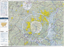
that they complement, terminal area charts depict topographic features and other information of interest to aviators flying visually, including major landmarks, terrain elevations, visual navigation routes, ground-based navigation aids, airports, rivers, cities, and airspace boundaries. TACs are more
71:
detailed than sectional charts, and are scaled at 1:250,000 (as opposed to 1:500,000 for sectional charts) to permit inclusion of more detail. TACs contain information on approach, departure, and transition rules and procedures for the congested Class B areas around major airports.
175:
110:
180:
75:
82:) that produce equivalent, certified charts, often with some added value over the government charts, but with a higher price.
43:
195:
131:
105:
190:
159:
39:
86:
185:
35:
54:
89:, a simplified chart that shows preferred VFR routes through the area covered by the TAC.
67:
169:
20:
74:
Terminal area charts for the US are maintained and published by the United States
79:
27:
24:
42:
that depict areas surrounding major airports, primarily those with
53:
85:
The reverse side of a paper copy of the TAC often provides a
92:
TACs are updated every 56 days and historically were called
132:"Local Aeronautical Chart, Seattle, October 21, 1954"
111:Aeronautical chart conventions (United States)
8:
160:VFR Terminal Area Raster Aeronautical Charts
113:Conventions used in U.S. aeronautical charts
78:, and by commercial enterprises (notably
176:Air traffic control in the United States
123:
7:
14:
76:Federal Aviation Administration
136:Museum of History and Industry
38:intended for navigation under
1:
181:Air traffic control in Canada
162:- Current charts from the FAA
212:
106:Index of aviation articles
94:local aeronautical charts
58:FAA-Terminal Area Chart
63:
57:
60:Baltimore-Washington
32:terminal area charts
196:Aeronautical charts
40:Visual Flight Rules
36:aeronautical charts
64:
16:Aeronautical chart
203:
147:
146:
144:
142:
128:
68:sectional charts
211:
210:
206:
205:
204:
202:
201:
200:
166:
165:
156:
151:
150:
140:
138:
130:
129:
125:
120:
102:
52:
17:
12:
11:
5:
209:
207:
199:
198:
193:
191:Air navigation
188:
183:
178:
168:
167:
164:
163:
155:
154:External links
152:
149:
148:
122:
121:
119:
116:
115:
114:
108:
101:
98:
51:
48:
15:
13:
10:
9:
6:
4:
3:
2:
208:
197:
194:
192:
189:
187:
184:
182:
179:
177:
174:
173:
171:
161:
158:
157:
153:
137:
133:
127:
124:
117:
112:
109:
107:
104:
103:
99:
97:
95:
90:
88:
83:
81:
77:
72:
69:
66:Like the VFR
61:
56:
49:
47:
45:
41:
37:
33:
29:
26:
22:
21:United States
139:. Retrieved
135:
126:
93:
91:
87:flyway chart
84:
73:
65:
59:
31:
18:
141:23 November
170:Categories
118:References
46:airspace.
186:Map types
62:from 2011
100:See also
80:Jeppesen
50:Overview
28:aviation
44:Class B
25:Canada
143:2021
34:are
23:and
19:In
172::
134:.
96:.
30:,
145:.
Text is available under the Creative Commons Attribution-ShareAlike License. Additional terms may apply.