281:
293:
29:
397:
502:
309:
280:
292:
209:
Continuing from the south, it is a 32-mile (51 km) trek to String Lake, passing in and out of
Bridger-Teton National Forest twice, traversing the
242:
377:
420:
368:
225:. It is a challenge with 9,681 feet total ascent and 10,779 feet total descent. The trail also traverses the high alpine meadows of
373:
168:
190:
provides a gradual ascent into the Range, where it connects with the TCT. The Trail is most easily accessed by riding the
164:
130:
186:
Beginning in the south, the Teton Crest Trail can be accessed in several ways. From inside the
National Park, the
176:
314:
191:
441:
363:
487:
33:
463:
187:
183:
calls the Trail one of the "Best Hikes Ever," with "mesmerizing and constant views of jagged peaks."
339:
199:
28:
319:
230:
210:
229:
in the
Bridger-Teton National Forest. From Hurricane Pass, the trail provides easy access to
222:
234:
214:
218:
135:
496:
203:
195:
160:
226:
139:
172:
53:
152:
257:
244:
80:
60:
202:. From outside the Park, the Teton Crest Trail can be accessed via the
156:
206:
Trail, one of several routes through adjacent
National Forest lands.
320:
Trip report with many pictures and maps of the Teton Crest Trail
36:
and the northwest view of Grand Teton from the Teton Crest Trail
237:
as it follows the North and South forks of the
Cascade Creek.
233:, and parallels the west side of major peaks of the
151:is a 40-mile (64 km) long hiking trail in the
129:
121:
113:
105:
97:
89:
79:
71:
59:
49:
41:
21:
310:List of hiking trails in Grand Teton National Park
194:, which transports sightseers and hikers from the
93:Paintbrush Divide, 10,645 ft (3,245 m)
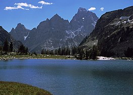
67:String Lake, Grand Teton National Park, Wyoming
8:
503:Hiking trails of Grand Teton National Park
101:String Lake, 6,870 ft (2,090 m)
421:"Best Hikes Ever: Teton Crest Trail, WY"
378:United States Department of the Interior
331:
276:
462:Potterfield, Peter (August 10, 2010).
358:
356:
298:Schoolroom Glacier from Hurricane Pass
18:
7:
444:. Greater Yellowstone Resource Guide
342:. Greater Yellowstone Resource Guide
16:Hiking trail in the state of Wyoming
369:Geographic Names Information System
213:and several high passes including
14:
291:
279:
169:Caribou-Targhee National Forests
27:
374:United States Geological Survey
464:"Hiking the Teton Crest Trail"
1:
402:(Map). Topoquest (USGS Quads)
286:Footbridge across String Lake
488:Teton Crest Trail Guide Book
85:3,775 ft (1,151 m)
519:
258:43.7143727°N 110.8549370°W
177:Grand Teton National Park
26:
263:43.7143727; -110.8549370
192:Jackson Hole Aerial Tram
45:40 mi (64 km)
65:Phillips Pass, Wyoming
442:"Phillips Pass Trail"
423:. Backpacker Magazine
198:Resort to the top of
466:. Great Outdoors.com
188:Granite Canyon Trail
364:"Teton Crest Trail"
340:"Teton Crest Trail"
254: /
200:Rendezvous Mountain
181:Backpacker Magazine
163:, on the border of
231:Schoolroom Glacier
211:Death Canyon Shelf
159:that extends from
223:Paintbrush Divide
149:Teton Crest Trail
145:
144:
22:Teton Crest Trail
510:
475:
474:
472:
471:
459:
453:
452:
450:
449:
438:
432:
431:
429:
428:
417:
411:
410:
408:
407:
394:
388:
387:
385:
384:
360:
351:
350:
348:
347:
336:
295:
283:
269:
268:
266:
265:
264:
259:
255:
252:
251:
250:
247:
81:Elevation change
31:
19:
518:
517:
513:
512:
511:
509:
508:
507:
493:
492:
484:
479:
478:
469:
467:
461:
460:
456:
447:
445:
440:
439:
435:
426:
424:
419:
418:
414:
405:
403:
399:Grand Teton, WY
396:
395:
391:
382:
380:
362:
361:
354:
345:
343:
338:
337:
333:
328:
306:
299:
296:
287:
284:
275:
262:
260:
256:
253:
248:
245:
243:
241:
240:
235:Cathedral Group
215:Mount Meek Pass
138:
66:
37:
17:
12:
11:
5:
516:
514:
506:
505:
495:
494:
491:
490:
483:
482:External links
480:
477:
476:
454:
433:
412:
389:
352:
330:
329:
327:
324:
323:
322:
317:
312:
305:
302:
301:
300:
297:
290:
288:
285:
278:
274:
271:
219:Hurricane Pass
143:
142:
136:Severe weather
133:
127:
126:
123:
119:
118:
117:Summer to Fall
115:
111:
110:
107:
103:
102:
99:
95:
94:
91:
87:
86:
83:
77:
76:
73:
69:
68:
63:
57:
56:
51:
47:
46:
43:
39:
38:
32:
24:
23:
15:
13:
10:
9:
6:
4:
3:
2:
515:
504:
501:
500:
498:
489:
486:
485:
481:
465:
458:
455:
443:
437:
434:
422:
416:
413:
401:
400:
393:
390:
379:
375:
371:
370:
365:
359:
357:
353:
341:
335:
332:
325:
321:
318:
316:
313:
311:
308:
307:
303:
294:
289:
282:
277:
272:
270:
267:
238:
236:
232:
228:
224:
220:
216:
212:
207:
205:
204:Phillips Pass
201:
197:
196:Teton Village
193:
189:
184:
182:
178:
174:
170:
166:
165:Bridger Teton
162:
161:Phillips Pass
158:
154:
150:
141:
140:Grizzly bears
137:
134:
132:
128:
124:
120:
116:
112:
108:
104:
100:
96:
92:
90:Highest point
88:
84:
82:
78:
74:
70:
64:
62:
58:
55:
52:
48:
44:
40:
35:
34:Lake Solitude
30:
25:
20:
468:. Retrieved
457:
446:. Retrieved
436:
425:. Retrieved
415:
404:. Retrieved
398:
392:
381:. Retrieved
367:
344:. Retrieved
334:
239:
227:Alaska Basin
208:
185:
180:
148:
146:
98:Lowest point
315:Backpacking
261: /
249:110°51′18″W
173:String Lake
125:Teton Range
54:Teton Range
470:2012-02-12
448:2015-08-11
427:2015-08-11
406:2012-02-12
383:2012-02-12
346:2012-02-12
326:References
246:43°42′52″N
153:U.S. state
106:Difficulty
61:Trailheads
109:Strenuous
497:Category
304:See also
50:Location
273:Gallery
157:Wyoming
131:Hazards
122:Sights
114:Season
75:Hiking
42:Length
171:, to
221:and
167:and
147:The
175:in
155:of
72:Use
499::
376:,
372:.
366:.
355:^
217:,
179:.
473:.
451:.
430:.
409:.
386:.
349:.
Text is available under the Creative Commons Attribution-ShareAlike License. Additional terms may apply.