42:
525:
133:
847:
519:
392:
113:
298:) was formed into a subdivision of Prome district; and in 1870 it was erected into a separate jurisdiction and placed under a deputy-commissioner. It was formerly in the Irrawaddy division of Lower Burma, but was transferred to Upper Burma for administrative purposes in 1896. In the early 20th century, the area contained the wing of a British battalion and a local regiment.
49:
285:
Several salt and hot springs exist. The principal wild animals are elephants, rhinoceros, tigers, leopards, black bears and wild hog. During the 19th century, the chief products were rice, cotton, oil-seeds and tobacco; cutch was also very abundant, and the manufacture of the dye-stuff was carried on
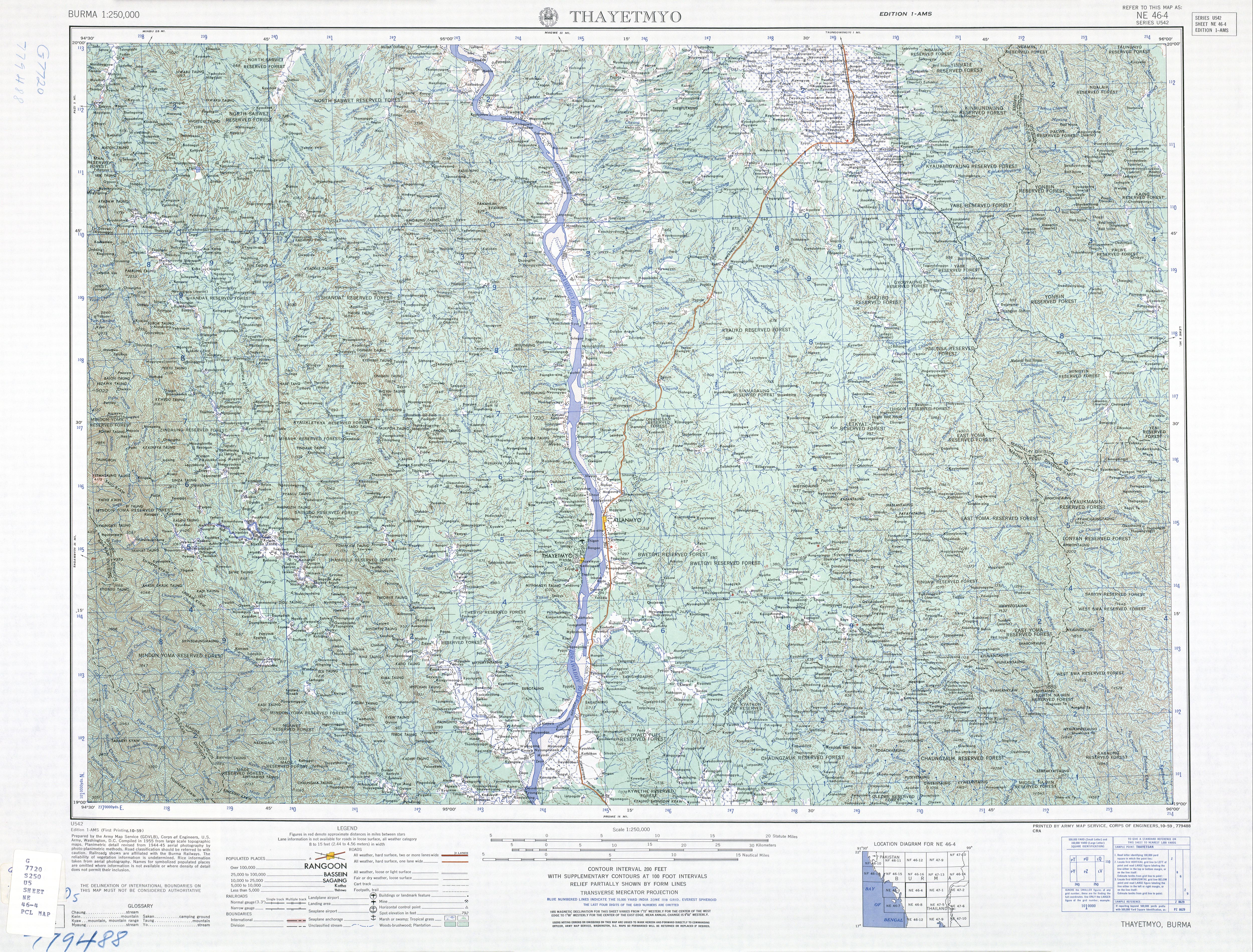
282:, and the face of the country is otherwise broken by low ranges of hills, many of which have no vegetation. The greater part of the district is wooded, and the ranges east and west are covered with forests. The chief river is the Irrawaddy, which traverses Thayet from north to south.
907:
412:
888:
455:
912:
407:
125:
73:
917:
881:
41:
336:"Myanmar: Regions, States, Major Cities & Towns - Population Statistics, Maps, Charts, Weather and Web Information"
448:
874:
306:
In the 1960s limestone quarries a few miles south of Thayet were developed to supply the town's cement factory.
219:
105:
286:
extensively. Three oil-wells were sunk in 1883 at
Pedaukpin, but they were found unprofitable and abandoned.
675:
508:
441:
561:
322:
566:
726:
781:
680:
604:
157:
145:
806:
335:
637:
594:
858:
660:
642:
627:
614:
556:
551:
275:
230:
207:
736:
685:
670:
652:
622:
546:
533:
524:
503:
493:
485:
477:
263:
247:
235:
162:
150:
427:
224:
786:
741:
665:
599:
589:
584:
576:
541:
518:
901:
771:
632:
464:
403:
398:
239:
194:
138:
846:
811:
791:
701:
498:
259:
821:
279:
175:
416:. Vol. 26 (11th ed.). Cambridge University Press. pp. 728–729.
88:
75:
801:
190:
185:
776:
294:
On the annexation of Pegu by the
British in 1852–53, Thayet (then called
251:
854:
826:
796:
766:
756:
751:
706:
243:
118:
746:
721:
716:
761:
731:
711:
397:
This article incorporates text from a publication now in the
262:. Thayet is the administrative seat of both Thayet District and
433:
255:
437:
323:
Burma 1:250,000 topographic map, Series U542, NE 46-4 Thayetmyo
266:. As of 2014, the population was 20,251 in the city proper.
357:
355:
862:
694:
651:
613:
575:
532:
484:
184:
173:
168:
156:
144:
124:
104:
21:
246:. It is a port on the right (western) bank of the
428:"Thayetmyo Map — Satellite Images of Thayetmyo"
882:
449:
211:
8:
889:
875:
456:
442:
434:
18:
373:
361:
315:
183:
167:
103:
68:
34:
229:
172:
155:
143:
123:
7:
843:
841:
908:Populated places in Thayet District
325:U.S. Army Map Service, October 1959
861:. You can help Knowledge (XXG) by
14:
845:
523:
517:
390:
131:
111:
47:
40:
48:
16:City in Magway Region, Myanmar
1:
913:Township capitals of Myanmar
250:, across and just south of
934:
840:
515:
471:
212:
69:
35:
28:
918:Myanmar geography stubs
413:Encyclopædia Britannica
234:) is a capital city in
857:location article is a
278:, and on the east the
695:Main cities and towns
562:Taungdwingyi Township
340:www.citypopulation.de
89:19.32500°N 95.18306°E
567:Yenangyaung Township
509:Kyaukhtu Subtownship
274:On the west are the
681:Sinbaungwe Township
376:, pp. 728–729.
85: /
605:Sidoktaya Township
94:19.32500; 95.18306
870:
869:
835:
834:
638:Seikphyu Township
595:Pwintbyu Township
201:
200:
61:Location in Burma
925:
891:
884:
877:
849:
842:
661:Aunglan Township
643:Yesagyo Township
628:Pakokku Township
615:Pakokku District
557:Natmauk Township
552:Myothit Township
527:
521:
458:
451:
444:
435:
417:
396:
394:
393:
377:
371:
365:
359:
350:
349:
347:
346:
332:
326:
320:
276:Arakan Mountains
233:
226:
217:
216:
215:
137:
135:
134:
117:
115:
114:
100:
99:
97:
96:
95:
90:
86:
83:
82:
81:
78:
51:
50:
44:
19:
933:
932:
928:
927:
926:
924:
923:
922:
898:
897:
896:
895:
838:
836:
831:
690:
686:Thayet Township
676:Minhla Township
671:Mindon Township
653:Thayet District
647:
623:Myaing Township
609:
571:
547:Magway Township
534:Magway District
528:
522:
513:
504:Htilin Township
494:Gangaw Township
486:Gangaw District
480:
467:
462:
424:
406:, ed. (1911). "
402:
391:
389:
386:
381:
380:
372:
368:
360:
353:
344:
342:
334:
333:
329:
321:
317:
312:
304:
292:
272:
264:Thayet Township
248:Irrawaddy River
236:Thayet District
231:[θəjɛʔ]
213:
163:Thayet Township
151:Thayet District
132:
130:
112:
110:
93:
91:
87:
84:
79:
76:
74:
72:
71:
65:
64:
63:
62:
59:
58:
57:
56:
52:
31:
24:
17:
12:
11:
5:
931:
929:
921:
920:
915:
910:
900:
899:
894:
893:
886:
879:
871:
868:
867:
850:
833:
832:
830:
829:
824:
819:
814:
809:
804:
799:
794:
789:
784:
779:
774:
769:
764:
759:
754:
749:
744:
739:
734:
729:
724:
719:
714:
709:
704:
698:
696:
692:
691:
689:
688:
683:
678:
673:
668:
666:Kamma Township
663:
657:
655:
649:
648:
646:
645:
640:
635:
630:
625:
619:
617:
611:
610:
608:
607:
602:
600:Salin Township
597:
592:
590:Ngape Township
587:
585:Minbu Township
581:
579:
577:Minbu District
573:
572:
570:
569:
564:
559:
554:
549:
544:
542:Chauk Township
538:
536:
530:
529:
516:
514:
512:
511:
506:
501:
496:
490:
488:
482:
481:
472:
469:
468:
463:
461:
460:
453:
446:
438:
432:
431:
423:
422:External links
420:
419:
418:
404:Chisholm, Hugh
385:
382:
379:
378:
366:
364:, p. 728.
351:
327:
314:
313:
311:
308:
303:
300:
291:
288:
271:
268:
199:
198:
188:
182:
181:
178:
171:
170:
166:
165:
160:
154:
153:
148:
142:
141:
128:
122:
121:
108:
102:
101:
67:
66:
60:
54:
53:
46:
45:
39:
38:
37:
36:
33:
32:
29:
26:
25:
22:
15:
13:
10:
9:
6:
4:
3:
2:
930:
919:
916:
914:
911:
909:
906:
905:
903:
892:
887:
885:
880:
878:
873:
872:
866:
864:
860:
856:
851:
848:
844:
839:
828:
825:
823:
820:
818:
815:
813:
810:
808:
805:
803:
800:
798:
795:
793:
790:
788:
785:
783:
780:
778:
775:
773:
770:
768:
765:
763:
760:
758:
755:
753:
750:
748:
745:
743:
740:
738:
735:
733:
730:
728:
725:
723:
720:
718:
715:
713:
710:
708:
705:
703:
700:
699:
697:
693:
687:
684:
682:
679:
677:
674:
672:
669:
667:
664:
662:
659:
658:
656:
654:
650:
644:
641:
639:
636:
634:
633:Pauk Township
631:
629:
626:
624:
621:
620:
618:
616:
612:
606:
603:
601:
598:
596:
593:
591:
588:
586:
583:
582:
580:
578:
574:
568:
565:
563:
560:
558:
555:
553:
550:
548:
545:
543:
540:
539:
537:
535:
531:
526:
520:
510:
507:
505:
502:
500:
497:
495:
492:
491:
489:
487:
483:
479:
475:
470:
466:
465:Magway Region
459:
454:
452:
447:
445:
440:
439:
436:
429:
426:
425:
421:
415:
414:
409:
405:
400:
399:public domain
388:
387:
383:
375:
374:Chisholm 1911
370:
367:
363:
362:Chisholm 1911
358:
356:
352:
341:
337:
331:
328:
324:
319:
316:
309:
307:
301:
299:
297:
289:
287:
283:
281:
277:
269:
267:
265:
261:
257:
253:
249:
245:
241:
240:Magway Region
237:
232:
228:; pronounced
227:
221:
209:
205:
196:
192:
189:
187:
179:
177:
174: •
164:
161:
159:
152:
149:
147:
140:
139:Magway Region
129:
127:
120:
109:
107:
98:
70:Coordinates:
43:
27:
20:
863:expanding it
852:
837:
816:
812:Taungdwingyi
499:Saw Township
473:
411:
369:
343:. Retrieved
339:
330:
318:
305:
295:
293:
284:
273:
256:Pyay (Prome)
223:
203:
202:
822:Yenangyaung
242:in central
92: /
902:Categories
807:Sinbyugyun
345:2021-04-02
280:Pegu Range
254:, between
169:Population
80:95°10′59″E
77:19°19′30″N
802:Sidoktaya
430:Maplandia
408:Thayetmyo
296:Thayetmyo
270:Geography
186:Time zone
777:Pwintbyu
302:Industry
252:Allanmyo
191:UTC+6.30
158:Township
146:District
855:Myanmar
827:Yesagyo
797:Seikpyu
767:Pakokku
757:Natmauk
752:Myothit
707:Aunglan
474:Capital
401::
384:Sources
290:History
244:Myanmar
208:Burmese
119:Myanmar
106:Country
817:Thayet
747:Myaing
742:Minhla
737:Mindon
722:Htilin
717:Gangaw
702:Magway
478:Magway
395:
260:Magway
204:Thayet
180:20,251
136:
126:Region
116:
55:Thayet
23:Thayet
853:This
787:Salin
762:Ngape
732:Minbu
727:Kamma
712:Chauk
310:Notes
225:sarak
220:MLCTS
176:Urban
859:stub
782:Sagu
772:Pauk
258:and
214:သရက်
30:City
792:Saw
410:".
238:of
195:MST
904::
476::
354:^
338:.
222::
218:;
210::
890:e
883:t
876:v
865:.
457:e
450:t
443:v
348:.
206:(
197:)
193:(
Text is available under the Creative Commons Attribution-ShareAlike License. Additional terms may apply.
