311:
472:
350:
30:
22:
542:
147:
The
Environment Agency measures the water quality of the river systems in England. Each is given an overall ecological status, which may be one of five levels: high, good, moderate, poor and bad. There are several components that are used to determine this, including biological status, which looks at
118:
The Rythe has many clay banks and its lack of depth and width at pinch points has been implicated in flash flooding in gardens and drainage systems, particularly for its mid-course headwaters in
Claygate. A flood alleviation scheme was therefore drawn up in 2002 between flood alleviation authorities.
48:, England. It runs through woodland for approximately half of its course, but is also culverted and passes through suburban gardens. It joins the Thames between
460:
115:. It receives its shorter east branch (rising in Surbiton Golf Course, Long Ditton) then turns running into the Thames near Ferry Road, 800 metres north.
156:
and fish. Chemical status, which compares the concentrations of various chemicals against known safe concentrations, is rated good or fail.
438:
409:
453:
496:
224:
879:
569:
819:
446:
763:
77:
678:
501:
874:
855:
851:
723:
229:
804:
718:
647:
597:
284:
328:
799:
713:
315:
88:
354:
602:
829:
794:
789:
91:
into wooded
Arbrook Common there joined by three further headwaters rising in the suburban village of
824:
758:
579:
112:
104:
839:
773:
768:
526:
73:
300:
135:
on the north-western border of the county of Surrey with the edge of the administrative county of
834:
814:
748:
564:
387:
627:
592:
559:
516:
262:
809:
728:
612:
607:
506:
96:
111:. It then follows the Portsmouth Road east through part of Thames Ditton and alongside the
698:
657:
637:
132:
250:
310:
688:
622:
398:
868:
708:
124:
100:
61:
49:
521:
370:
301:"Glossary (see Biological quality element; Chemical status; and Ecological status)"
149:
120:
41:
273:
743:
738:
693:
652:
617:
587:
383:
128:
53:
753:
703:
632:
511:
488:
153:
424:
411:
733:
673:
531:
476:
349:
119:
Some of its course is owned by landowners. The Rythe discharges into the
92:
107:
roundabout at part of a remnant of the wooded Ditton Marsh, now part of
541:
81:
72:
The Rythe rises at several sources, the furthest being four sources in
29:
21:
683:
480:
471:
136:
45:
550:
108:
28:
20:
442:
314:
Text was copied from this source, which is available under an
99:). The Rythe carries on north bounding Littleworth Common and
84:
where on its northern edge it combines to form the
Arbrook.
782:
666:
578:
549:
487:
274:Thames Ditton Virtual Village Village Boundaries
60:which drains Arbrook Common, a woodland area of
263:Monograph No 4: More on boundaries and old maps
454:
8:
139:. Its lowest section lies in Thames Ditton.
461:
447:
439:
360:
161:
25:A forked headwater of the Rythe Claygate
307:. Environment Agency. 17 February 2016.
246:
244:
240:
209:20.04 km (7.74 sq mi)
7:
159:Water quality of the Rythe in 2019:
287:Battle lines drawn in sewer inquiry
76:(woodland), all in the parish and
14:
540:
470:
348:
309:
225:Tributaries of the River Thames
131:to the east on the reach above
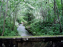
33:The Rythe in Littleworth Common
206:5.099 km (3.168 mi)
148:the quantity and varieties of
16:River in north Surrey, England
1:
570:Wey and Godalming Navigations
820:Queen Elizabeth II Reservoir
316:Open Government Licence v3.0
56:. Its longest branch is the
764:Thorpe Park No 1 Gravel Pit
377:Next confluence downstream
95:, immediately to the east (
87:It runs under the six-lane
896:
679:Claremont Landscape Garden
848:
724:McLaren Technology Centre
667:Lakes, ponds and wetlands
538:
230:List of rivers of England
805:King George VI Reservoir
719:Lakeside Leisure Complex
598:River Bourne, Addlestone
365:Next confluence upstream
800:Kempton Park Reservoirs
714:Kempton Park Racecourse
333:Catchment Data Explorer
305:Catchment Data Explorer
603:River Bourne, Chertsey
401:, Raven's Ait (north)
253:The Church of England.
40:is a tributary of the
34:
26:
880:Thames drainage basin
830:Stain Hill Reservoirs
795:Island Barn Reservoir
790:Bessborough Reservoir
580:Ordinary watercourses
335:. Environment Agency.
289:Get Surrey 12/11/2002
32:
24:
825:Queen Mary Reservoir
729:Mercers Country Park
357:at Wikimedia Commons
318:. © Crown copyright.
113:South West Main Line
840:Wraysbury Reservoir
774:Winkworth Arboretum
769:Virginia Water Lake
527:River Tillingbourne
421: /
835:Staines Reservoirs
815:Molesey Reservoirs
749:Papercourt Marshes
565:Wey and Arun Canal
251:Oxshott parish map
35:
27:
862:
861:
560:Basingstoke Canal
405:
404:
353:Media related to
216:
215:
212:Heavily modified
887:
875:Rivers of Surrey
810:Knight Reservoir
544:
507:Cranleigh Waters
497:River Blackwater
475:
474:
463:
456:
449:
440:
436:
435:
433:
432:
431:
426:
425:51.391°N 0.326°W
422:
419:
418:
417:
414:
361:
352:
337:
336:
325:
319:
313:
308:
297:
291:
282:
276:
271:
265:
260:
254:
248:
162:
74:Prince's Coverts
895:
894:
890:
889:
888:
886:
885:
884:
865:
864:
863:
858:
844:
778:
739:Sherbourne Pond
699:Goldsworth Park
674:Busbridge Lakes
662:
658:Wraysbury River
574:
553:and navigations
545:
536:
483:
469:
467:
429:
427:
423:
420:
415:
412:
410:
408:
407:
386:
345:
340:
327:
326:
322:
299:
298:
294:
283:
279:
272:
268:
261:
257:
249:
242:
238:
221:
179:
174:
169:
145:
133:Teddington Lock
70:
17:
12:
11:
5:
893:
891:
883:
882:
877:
867:
866:
860:
859:
849:
846:
845:
843:
842:
837:
832:
827:
822:
817:
812:
807:
802:
797:
792:
786:
784:
780:
779:
777:
776:
771:
766:
761:
756:
751:
746:
741:
736:
731:
726:
721:
716:
711:
706:
701:
696:
691:
689:Frensham Ponds
686:
681:
676:
670:
668:
664:
663:
661:
660:
655:
650:
645:
640:
635:
630:
625:
623:Hogsmill River
620:
615:
610:
608:Cobblers Brook
605:
600:
595:
590:
584:
582:
576:
575:
573:
572:
567:
562:
556:
554:
547:
546:
539:
537:
535:
534:
529:
524:
519:
514:
509:
504:
499:
493:
491:
485:
484:
468:
466:
465:
458:
451:
443:
430:51.391; -0.326
403:
402:
399:Longford River
396:
391:
380:
379:
374:
367:
359:
358:
344:
343:External links
341:
339:
338:
320:
292:
277:
266:
255:
239:
237:
234:
233:
232:
227:
220:
217:
214:
213:
210:
207:
204:
201:
198:
195:
191:
190:
187:
184:
181:
176:
171:
166:
144:
141:
69:
66:
15:
13:
10:
9:
6:
4:
3:
2:
892:
881:
878:
876:
873:
872:
870:
857:
853:
847:
841:
838:
836:
833:
831:
828:
826:
823:
821:
818:
816:
813:
811:
808:
806:
803:
801:
798:
796:
793:
791:
788:
787:
785:
781:
775:
772:
770:
767:
765:
762:
760:
757:
755:
752:
750:
747:
745:
742:
740:
737:
735:
732:
730:
727:
725:
722:
720:
717:
715:
712:
710:
709:Henfold Lakes
707:
705:
702:
700:
697:
695:
692:
690:
687:
685:
682:
680:
677:
675:
672:
671:
669:
665:
659:
656:
654:
651:
649:
646:
644:
641:
639:
636:
634:
631:
629:
626:
624:
621:
619:
616:
614:
611:
609:
606:
604:
601:
599:
596:
594:
591:
589:
586:
585:
583:
581:
577:
571:
568:
566:
563:
561:
558:
557:
555:
552:
548:
543:
533:
530:
528:
525:
523:
520:
518:
515:
513:
510:
508:
505:
503:
500:
498:
495:
494:
492:
490:
486:
482:
478:
473:
464:
459:
457:
452:
450:
445:
444:
441:
437:
434:
400:
397:
395:
392:
389:
385:
382:
381:
378:
375:
373:
372:
368:
366:
363:
362:
356:
351:
347:
346:
342:
334:
330:
324:
321:
317:
312:
306:
302:
296:
293:
290:
288:
285:Paul McManus
281:
278:
275:
270:
267:
264:
259:
256:
252:
247:
245:
241:
235:
231:
228:
226:
223:
222:
218:
211:
208:
205:
202:
199:
196:
193:
192:
188:
185:
182:
177:
172:
167:
164:
163:
160:
157:
155:
151:
150:invertebrates
143:Water quality
142:
140:
138:
134:
130:
126:
125:Thames Ditton
122:
116:
114:
110:
106:
102:
101:Hinchley Wood
98:
94:
90:
85:
83:
79:
75:
67:
65:
63:
62:Esher Commons
59:
55:
51:
50:Thames Ditton
47:
43:
39:
31:
23:
19:
850:Categories:
759:Sutton Place
648:Windle Brook
642:
522:River Thames
406:
393:
376:
371:River Thames
369:
364:
332:
323:
304:
295:
286:
280:
269:
258:
158:
146:
117:
105:Scilly Isles
86:
71:
57:
42:River Thames
37:
36:
18:
744:Silent Pool
694:Gatton Park
684:Enton Lakes
653:Wish Stream
618:River Ember
588:Abbey River
502:River Colne
489:Main rivers
428: /
384:River Ember
355:River Rythe
154:angiosperms
129:Long Ditton
54:Long Ditton
869:Categories
783:Reservoirs
754:Silvermere
704:Hedgecourt
633:Pipp Brook
613:River Eden
512:River Mole
413:51°23′28″N
388:River Mole
236:References
168:Ecological
97:right bank
734:Painshill
643:The Rythe
628:Law Brook
593:River Ash
532:River Wey
517:River Ock
477:Hydrology
416:0°19′34″W
394:The Rythe
186:Catchment
123:dividing
44:in north
38:The Rythe
390:(south)
219:See also
189:Channel
173:Chemical
93:Claygate
638:The Rye
329:"Rythe"
178:Overall
165:Section
103:to the
82:Oxshott
58:Arbrook
856:Canals
852:Rivers
551:Canals
481:Surrey
194:Rythe
183:Length
180:Status
175:Status
170:Status
137:London
121:Thames
68:Course
46:Surrey
203:Poor
200:Fail
197:Poor
127:from
109:Esher
78:ward
52:and
479:of
80:of
871::
854:,
331:.
303:.
243:^
152:,
89:A3
64:.
462:e
455:t
448:v
Text is available under the Creative Commons Attribution-ShareAlike License. Additional terms may apply.