523:
475:
451:
535:
547:
511:
463:
487:
439:
181:
148:
174:
141:
581:
559:
499:
29:
595:
425:
zone, which is defined by the coldest month having an average mean temperature below 32 °F (0 °C), and at least 50% of the total annual precipitation being received during the spring and summer. This desert climate receives less than 10 inches (250 millimeters) of annual rainfall, and
486:
474:
522:
534:
96:
462:
757:
450:
353:
The
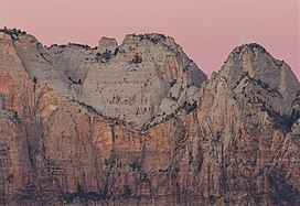
Sundial is situated in the "Towers of the Virgin", 2.5 mi (4.0 km) west of Zion's park headquarters, towering 3,600 feet (1,100 meters) above the floor of
510:
762:
752:
438:
615:
546:
173:
767:
692:
498:
558:
140:
722:
382:
418:
397:. This geographical feature was named by the park's third superintendent, Preston P. Patraw, because it had long been used as a
264:
492:
Towers of the Virgin. Left to right:The
Sundial, The Witch Head, Broken Tooth, Rotten Tooth, Altar of Sacrifice (upper right).
406:
89:
747:
742:
727:
610:
676:
338:
315:
228:
422:
390:
66:
56:
79:
688:
279:
370:
334:
291:
238:
620:
586:
330:
296:
252:
378:
366:
259:
71:
394:
374:
362:
245:
417:
Spring and fall are the most favorable seasons to visit The
Sundial. According to the
736:
402:
540:
The
Sundial (left), The Witch Head, Broken Tooth, Rotten Tooth, Altar of Sacrifice.
358:
308:
28:
600:
354:
480:
The West Temple (left), The
Sundial, The Witch Head, Altar of Sacrifice (right)
468:
The West Temple (left), The
Sundial, The Witch Head, Altar of Sacrifice (right)
576:
386:
373:
is set approximately one mile to the north-northeast. Other neighbors include
111:
98:
689:"Zion National Park, Utah, USA - Monthly weather forecast and Climate data"
318:
284:
528:
Mt. Kinesava (centered), The
Sundial to left, seen from Grafton cemetery
677:
U.S. Geological Survey
Geographic Names Information System: The Sundial
398:
716:
648:
46:
342:
218:
405:. The Sundial's name was officially adopted in 1934 by the
365:from this mountain. Its nearest higher neighbor is
307:
302:
290:
278:
273:
258:
244:
234:
224:
214:
206:
127:
88:
78:
65:
55:
45:
40:
21:
426:snowfall is generally light during the winter.
329:is a 7,590-foot (2,310-meter) elevation white
643:
641:
639:
637:
635:
504:The Sundial (left) and The Witch Head (right)
8:
444:West aspect of Sundial. West Temple to right
516:The West Temple (left), The Sundial (right)
616:Geology of the Zion and Kolob canyons area
18:
758:Sandstone formations of the United States
401:to regulate clocks in the nearby town of
456:The Sundial centered, from the southwest
631:
434:
16:Sandstone mountain in the state of Utah
672:
670:
668:
369:, one half mile to the southeast, and
695:from the original on January 27, 2019
7:
763:Landforms of Washington County, Utah
753:Mountains of Washington County, Utah
180:
147:
14:
593:
579:
557:
545:
533:
521:
509:
497:
485:
473:
461:
449:
437:
179:
172:
146:
139:
33:The Sundial, east aspect at dawn
27:
193:The Sundial (the United States)
407:U.S. Board on Geographic Names
1:
768:North American 2000 m summits
564:The Sundial from Chinle Trail
419:Köppen climate classification
196:Show map of the United States
51:7,590 ft (2,310 m)
421:system, it is located in a
361:which drains precipitation
84:0.38 mi (0.61 km)
784:
649:"Sundial, The - 7,590' UT"
112:37.2155109°N 113.0242192°W
611:List of mountains in Utah
132:
35:(The Witch Head to right)
26:
117:37.2155109; -113.0242192
61:530 ft (160 m)
423:Cold semi-arid climate
719:National Park Service
552:Moon over The Sundial
235:Protected area
108: /
748:Zion National Park
717:Zion National Park
371:Altar of Sacrifice
335:Zion National Park
333:summit located in
239:Zion National Park
41:Highest point
743:Mountains of Utah
691:. Weather Atlas.
345:, United States.
339:Washington County
324:
323:
775:
723:Weather forecast
705:
704:
702:
700:
685:
679:
674:
663:
662:
660:
659:
645:
621:Colorado Plateau
603:
598:
597:
596:
589:
587:Mountains portal
584:
583:
582:
561:
549:
537:
525:
513:
501:
489:
477:
465:
453:
441:
331:Navajo Sandstone
311:
297:Navajo sandstone
253:Colorado Plateau
248:
197:
183:
182:
176:
164:
163:Show map of Utah
160:Location in Utah
150:
149:
143:
123:
122:
120:
119:
118:
113:
109:
106:
105:
104:
101:
31:
19:
783:
782:
778:
777:
776:
774:
773:
772:
733:
732:
713:
708:
698:
696:
687:
686:
682:
675:
666:
657:
655:
653:listsofjohn.com
647:
646:
633:
629:
607:
606:
599:
594:
592:
585:
580:
578:
573:
568:
565:
562:
553:
550:
541:
538:
529:
526:
517:
514:
505:
502:
493:
490:
481:
478:
469:
466:
457:
454:
445:
442:
432:
415:
391:Bridge Mountain
367:The West Temple
351:
309:
268:Springdale West
246:
202:
201:
200:
199:
198:
195:
194:
191:
190:
189:
188:
184:
167:
166:
165:
162:
161:
158:
157:
156:
155:
151:
116:
114:
110:
107:
102:
99:
97:
95:
94:
72:The West Temple
36:
34:
17:
12:
11:
5:
781:
779:
771:
770:
765:
760:
755:
750:
745:
735:
734:
731:
730:
725:
720:
712:
711:External links
709:
707:
706:
680:
664:
630:
628:
625:
624:
623:
618:
613:
605:
604:
590:
575:
574:
572:
569:
567:
566:
563:
556:
554:
551:
544:
542:
539:
532:
530:
527:
520:
518:
515:
508:
506:
503:
496:
494:
491:
484:
482:
479:
472:
470:
467:
460:
458:
455:
448:
446:
443:
436:
433:
431:
428:
414:
411:
395:Mount Kinesava
375:The Witch Head
350:
347:
322:
321:
313:
305:
304:
300:
299:
294:
288:
287:
282:
276:
275:
271:
270:
262:
256:
255:
250:
242:
241:
236:
232:
231:
226:
222:
221:
216:
212:
211:
208:
204:
203:
192:
186:
185:
178:
177:
171:
170:
169:
168:
159:
153:
152:
145:
144:
138:
137:
136:
135:
134:
133:
130:
129:
125:
124:
92:
86:
85:
82:
76:
75:
69:
63:
62:
59:
53:
52:
49:
43:
42:
38:
37:
32:
24:
23:
15:
13:
10:
9:
6:
4:
3:
2:
780:
769:
766:
764:
761:
759:
756:
754:
751:
749:
746:
744:
741:
740:
738:
729:
726:
724:
721:
718:
715:
714:
710:
694:
690:
684:
681:
678:
673:
671:
669:
665:
654:
650:
644:
642:
640:
638:
636:
632:
626:
622:
619:
617:
614:
612:
609:
608:
602:
591:
588:
577:
570:
560:
555:
548:
543:
536:
531:
524:
519:
512:
507:
500:
495:
488:
483:
476:
471:
464:
459:
452:
447:
440:
435:
429:
427:
424:
420:
412:
410:
408:
404:
400:
396:
392:
388:
384:
380:
376:
372:
368:
364:
360:
356:
348:
346:
344:
341:of southwest
340:
336:
332:
328:
320:
317:
316:class 5+
314:
312:
310:Easiest route
306:
301:
298:
295:
293:
289:
286:
283:
281:
277:
272:
269:
266:
263:
261:
257:
254:
251:
249:
243:
240:
237:
233:
230:
227:
223:
220:
217:
213:
210:United States
209:
205:
175:
142:
131:
126:
121:
93:
91:
87:
83:
81:
77:
73:
70:
68:
64:
60:
58:
54:
50:
48:
44:
39:
30:
25:
20:
697:. Retrieved
683:
656:. Retrieved
652:
416:
383:The Sentinel
359:Virgin River
352:
326:
325:
292:Type of rock
267:
247:Parent range
601:Utah portal
355:Zion Canyon
349:Description
327:The Sundial
280:Age of rock
187:The Sundial
154:The Sundial
115: /
103:113°01′27″W
90:Coordinates
67:Parent peak
22:The Sundial
737:Categories
658:2020-09-10
627:References
387:Mount Spry
229:Washington
100:37°12′56″N
74:(7,810 ft)
57:Prominence
699:31 August
128:Geography
80:Isolation
47:Elevation
693:Archived
571:See also
379:Bee Hive
357:and the
319:climbing
303:Climbing
285:Jurassic
260:Topo map
728:Web cam
430:Gallery
413:Climate
403:Grafton
399:sundial
274:Geology
207:Country
393:, and
363:runoff
225:County
337:, in
215:State
701:2020
343:Utah
265:USGS
219:Utah
739::
667:^
651:.
634:^
409:.
389:,
385:,
381:,
377:,
703:.
661:.
Text is available under the Creative Commons Attribution-ShareAlike License. Additional terms may apply.