177:
200:
48:
284:
279:
206:
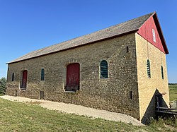
Walter Thomas was a Welsh immigrant. The barn was originally used for keeping livestock and hay. Eventually, it was converted for dairying. It was added to the State
Register of Historic Places in 2000 and to the
299:
74:
294:
289:
233:
208:
34:
238:
62:
252:
189:
176:
199:
160:
273:
47:
90:
76:
198:
175:
228:
285:
National
Register of Historic Places in Iowa County, Wisconsin
280:
Barns on the
National Register of Historic Places in Wisconsin
166:
153:
145:
137:
122:
114:
68:
57:
8:
300:Buildings and structures completed in 1881
46:
35:U.S. National Register of Historic Places
295:Limestone buildings in the United States
220:
180:Thomas Stone Barn - View from Northeast
229:"National Register Information System"
18:
7:
290:Dairy buildings in the United States
234:National Register of Historic Places
209:National Register of Historic Places
149:Late 19th And 20th Century Revivals
14:
255:. Wisconsin Historical Society
155:
1:
16:United States historic place
316:
154:NRHP reference
141:Isaac Jones/Walter Thomas
45:
41:
32:
25:
21:
253:"7777 State Road 18-151"
146:Architectural style
203:
181:
239:National Park Service
202:
179:
91:43.00806°N 89.92306°W
211:the following year.
190:Bareveld, Wisconsin.
63:Barneveld, Wisconsin
241:. November 2, 2013.
96:43.00806; -89.92306
86: /
204:
182:
118:less than one acre
186:Thomas Stone Barn
174:
173:
102:Thomas Stone Barn
52:Thomas Stone Barn
27:Thomas Stone Barn
307:
264:
263:
261:
260:
249:
243:
242:
225:
157:
133:
131:
110:
109:
107:
106:
105:
103:
98:
97:
92:
87:
84:
83:
82:
79:
61:7777 WI 18-151,
50:
19:
315:
314:
310:
309:
308:
306:
305:
304:
270:
269:
268:
267:
258:
256:
251:
250:
246:
227:
226:
222:
217:
197:
129:
127:
101:
99:
95:
93:
89:
88:
85:
80:
77:
75:
73:
72:
53:
37:
28:
17:
12:
11:
5:
313:
311:
303:
302:
297:
292:
287:
282:
272:
271:
266:
265:
244:
219:
218:
216:
213:
196:
193:
188:is located in
172:
171:
170:March 29, 2001
168:
164:
163:
158:
151:
150:
147:
143:
142:
139:
135:
134:
124:
120:
119:
116:
112:
111:
70:
66:
65:
59:
55:
54:
51:
43:
42:
39:
38:
33:
30:
29:
26:
23:
22:
15:
13:
10:
9:
6:
4:
3:
2:
312:
301:
298:
296:
293:
291:
288:
286:
283:
281:
278:
277:
275:
254:
248:
245:
240:
236:
235:
230:
224:
221:
214:
212:
210:
201:
194:
192:
191:
187:
178:
169:
167:Added to NRHP
165:
162:
159:
152:
148:
144:
140:
136:
125:
121:
117:
113:
108:
71:
67:
64:
60:
56:
49:
44:
40:
36:
31:
24:
20:
257:. Retrieved
247:
232:
223:
205:
185:
183:
94: /
69:Coordinates
274:Categories
259:2018-10-02
215:References
100: (
81:89°55′23″W
78:43°00′29″N
138:Architect
161:01000299
58:Location
195:History
128: (
123:Built
184:The
130:1881
126:1881
115:Area
156:No.
276::
237:.
231:.
262:.
132:)
104:)
Text is available under the Creative Commons Attribution-ShareAlike License. Additional terms may apply.