62:
48:
870:
87:
881:
94:
69:
294:
bridge in
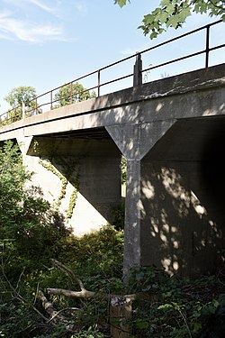
Michigan, and the only historically significant bridge of the type having multiple spans. The entire bridge is 169 feet (52 m) long and just over 20 feet (6.1 m) in width, with five spans of 35 feet (11 m) in length. The length of the structure is due to the wide
279:; two years later, the route was controlled by the Michigan Central. In 1919, a cutoff was constructed through Howard Township, linking the main Michigan Central line to the Airline. This bridge was constructed at the same time, probably from a design developed by the railroad company.
295:
right-of-way beneath, which was used as a railroad switchyard known as the "Hump." The bridge has an unusual brick deck, which has a slight arch. The original bridge railings are metal pipe panels strung between concrete posts. The bridge has maintained an excellent integrity.
759:
854:
790:
774:
905:
764:
915:
849:
795:
436:
816:
718:
749:
683:
648:
723:
628:
588:
413:
688:
678:
673:
653:
769:
603:
518:
638:
633:
508:
925:
728:
693:
598:
573:
713:
663:
643:
618:
608:
593:
583:
568:
548:
523:
513:
503:
733:
708:
613:
553:
533:
528:
498:
488:
668:
623:
563:
538:
493:
800:
698:
578:
543:
754:
703:
658:
558:
127:
466:
451:
406:
482:
86:
920:
884:
399:
61:
385:
874:
446:
422:
320:
244:
34:
910:
837:
263:, located about .5 miles (0.80 km) west of this site, was constructed through Cass County in 1848. Just after the
193:
842:
821:
268:
236:
368:
260:
240:
115:
47:
456:
461:
441:
325:
264:
272:
198:
391:
276:
290:
The
Thomson Road–Air Line Railroad Bridge is one of the oldest examples of a concrete
211:
899:
282:
The railroad beneath the bridge has been abandoned for many years and is overgrown.
855:
University and college buildings listed on the
National Register of Historic Places
346:
142:
129:
850:
List of jails and prisons on the
National Register of Historic Places
349:. Michigan State Housing Development Authority: Historic Sites Online
291:
248:
186:
906:
Road bridges on the
National Register of Historic Places in Michigan
315:
395:
916:
National
Register of Historic Places in Cass County, Michigan
93:
68:
247:
in 1999. It is one of the oldest examples of a concrete
235:, is a bridge located on Thomson Road over the abandoned
830:
809:
783:
742:
475:
452:
History of the
National Register of Historic Places
429:
217:
204:
192:
181:
166:
158:
121:
110:
926:Buildings and structures in Cass County, Michigan
483:List of U.S. National Historic Landmarks by state
875:National Register of Historic Places portal
251:bridge in Michigan, and has a rare brick deck.
407:
8:
114:Thomson Rd. over abandoned RR right-of-way,
414:
400:
392:
46:
423:U.S. National Register of Historic Places
35:U.S. National Register of Historic Places
347:"Thompson Road/Air Line Railroad Bridge"
341:
339:
337:
335:
304:
316:"National Register Information System"
310:
308:
18:
921:Concrete bridges in the United States
229:Thomson Road–Air Line Railroad Bridge
27:Thomson Road–Air Line Railroad Bridge
7:
321:National Register of Historic Places
245:National Register of Historic Places
838:National Historic Preservation Act
275:with the Michigan Central line at
14:
880:
879:
868:
92:
85:
67:
60:
267:, a new rail line known as the
199:Highway Bridges of Michigan MPS
791:Federated States of Micronesia
437:Architectural style categories
206:
1:
101:Show map of the United States
16:United States historic place
942:
843:Historic Preservation Fund
822:American Legation, Morocco
269:Michigan Air Line Railroad
237:Michigan Air Line Railroad
911:Bridges completed in 1919
863:
784:Lists by associated state
271:was constructed, linking
261:Michigan Central Railroad
241:Howard Township, Michigan
231:, also known as just the
205:NRHP reference
116:Howard Township, Michigan
54:
45:
41:
32:
25:
21:
765:Northern Mariana Islands
388:from HistoricBridges.org
243:. It was listed on the
182:Architectural style
760:Minor Outlying Islands
743:Lists by insular areas
457:Keeper of the Register
371:. HistoricBridges.org.
462:National Park Service
442:Contributing property
369:"Thomson Road Bridge"
326:National Park Service
259:The main line of the
143:41.88139°N 86.19472°W
817:District of Columbia
76:Show map of Michigan
233:Thomson Road Bridge
148:41.88139; -86.19472
139: /
162:less than one acre
893:
892:
447:Historic district
225:
224:
221:December 22, 1999
933:
883:
882:
873:
872:
871:
796:Marshall Islands
416:
409:
402:
393:
373:
372:
365:
359:
358:
356:
354:
343:
330:
329:
312:
239:right-of-way in
208:
177:
175:
154:
153:
151:
150:
149:
144:
140:
137:
136:
135:
132:
102:
96:
95:
89:
77:
71:
70:
64:
50:
19:
941:
940:
936:
935:
934:
932:
931:
930:
896:
895:
894:
889:
869:
867:
859:
826:
805:
779:
738:
471:
425:
420:
382:
377:
376:
367:
366:
362:
352:
350:
345:
344:
333:
328:. July 9, 2010.
314:
313:
306:
301:
288:
257:
173:
171:
147:
145:
141:
138:
133:
130:
128:
126:
125:
106:
105:
104:
103:
100:
99:
98:
97:
80:
79:
78:
75:
74:
73:
72:
37:
28:
17:
12:
11:
5:
939:
937:
929:
928:
923:
918:
913:
908:
898:
897:
891:
890:
888:
887:
877:
864:
861:
860:
858:
857:
852:
847:
846:
845:
834:
832:
828:
827:
825:
824:
819:
813:
811:
807:
806:
804:
803:
798:
793:
787:
785:
781:
780:
778:
777:
775:Virgin Islands
772:
767:
762:
757:
752:
750:American Samoa
746:
744:
740:
739:
737:
736:
731:
726:
721:
716:
711:
706:
701:
696:
691:
686:
684:South Carolina
681:
676:
671:
666:
661:
656:
651:
649:North Carolina
646:
641:
636:
631:
626:
621:
616:
611:
606:
601:
596:
591:
586:
581:
576:
571:
566:
561:
556:
551:
546:
541:
536:
531:
526:
521:
516:
511:
506:
501:
496:
491:
486:
479:
477:
476:Lists by state
473:
472:
470:
469:
467:Property types
464:
459:
454:
449:
444:
439:
433:
431:
427:
426:
421:
419:
418:
411:
404:
396:
390:
389:
381:
380:External links
378:
375:
374:
360:
331:
303:
302:
300:
297:
287:
284:
256:
253:
223:
222:
219:
215:
214:
209:
202:
201:
196:
190:
189:
183:
179:
178:
168:
164:
163:
160:
156:
155:
123:
119:
118:
112:
108:
107:
91:
90:
84:
83:
82:
81:
66:
65:
59:
58:
57:
56:
55:
52:
51:
43:
42:
39:
38:
33:
30:
29:
26:
23:
22:
15:
13:
10:
9:
6:
4:
3:
2:
938:
927:
924:
922:
919:
917:
914:
912:
909:
907:
904:
903:
901:
886:
878:
876:
866:
865:
862:
856:
853:
851:
848:
844:
841:
840:
839:
836:
835:
833:
829:
823:
820:
818:
815:
814:
812:
808:
802:
799:
797:
794:
792:
789:
788:
786:
782:
776:
773:
771:
768:
766:
763:
761:
758:
756:
753:
751:
748:
747:
745:
741:
735:
732:
730:
727:
725:
724:West Virginia
722:
720:
717:
715:
712:
710:
707:
705:
702:
700:
697:
695:
692:
690:
687:
685:
682:
680:
677:
675:
672:
670:
667:
665:
662:
660:
657:
655:
652:
650:
647:
645:
642:
640:
637:
635:
632:
630:
629:New Hampshire
627:
625:
622:
620:
617:
615:
612:
610:
607:
605:
602:
600:
597:
595:
592:
590:
589:Massachusetts
587:
585:
582:
580:
577:
575:
572:
570:
567:
565:
562:
560:
557:
555:
552:
550:
547:
545:
542:
540:
537:
535:
532:
530:
527:
525:
522:
520:
517:
515:
512:
510:
507:
505:
502:
500:
497:
495:
492:
490:
487:
484:
481:
480:
478:
474:
468:
465:
463:
460:
458:
455:
453:
450:
448:
445:
443:
440:
438:
435:
434:
432:
428:
424:
417:
412:
410:
405:
403:
398:
397:
394:
387:
384:
383:
379:
370:
364:
361:
348:
342:
340:
338:
336:
332:
327:
323:
322:
317:
311:
309:
305:
298:
296:
293:
285:
283:
280:
278:
274:
270:
266:
262:
254:
252:
250:
246:
242:
238:
234:
230:
220:
218:Added to NRHP
216:
213:
210:
203:
200:
197:
195:
191:
188:
184:
180:
169:
165:
161:
157:
152:
124:
120:
117:
113:
109:
88:
63:
53:
49:
44:
40:
36:
31:
24:
20:
689:South Dakota
679:Rhode Island
674:Pennsylvania
654:North Dakota
363:
353:December 29,
351:. Retrieved
319:
289:
281:
258:
232:
228:
226:
810:Other areas
770:Puerto Rico
604:Mississippi
519:Connecticut
286:Description
146: /
122:Coordinates
900:Categories
719:Washington
639:New Mexico
634:New Jersey
509:California
299:References
134:86°11′41″W
131:41°52′53″N
729:Wisconsin
694:Tennessee
599:Minnesota
574:Louisiana
265:Civil War
185:concrete
885:Category
714:Virginia
664:Oklahoma
644:New York
619:Nebraska
609:Missouri
594:Michigan
584:Maryland
569:Kentucky
549:Illinois
524:Delaware
514:Colorado
504:Arkansas
212:99001612
111:Location
831:Related
734:Wyoming
709:Vermont
614:Montana
554:Indiana
534:Georgia
529:Florida
499:Arizona
489:Alabama
273:Jackson
255:History
172: (
669:Oregon
624:Nevada
564:Kansas
539:Hawaii
494:Alaska
430:Topics
386:Images
292:T-beam
249:T-beam
187:T-beam
801:Palau
699:Texas
579:Maine
544:Idaho
277:Niles
167:Built
755:Guam
704:Utah
659:Ohio
559:Iowa
355:2013
227:The
174:1919
170:1919
159:Area
207:No.
194:MPS
902::
334:^
324:.
318:.
307:^
485::
415:e
408:t
401:v
357:.
176:)
Text is available under the Creative Commons Attribution-ShareAlike License. Additional terms may apply.