447:
139:
420:
432:
179:
146:
172:
389:
459:
29:
366:), causing them to drop their moisture in the form of rain or snow onto the Cascades. As a result, the west side of the Cascades experiences high precipitation, especially during the winter months in the form of snowfall. Because of
374:
danger. During winter months, weather is usually cloudy, but due to high pressure systems over the
Pacific Ocean that intensify during summer months, there is often little or no cloud cover during the summer.
446:
94:
588:
578:
138:
171:
583:
419:
593:
431:
404:
262:
323:
69:
87:
299:
236:
438:
307:
303:
226:
335:
311:
284:
216:
573:
64:
54:
458:
77:
544:
Beckey, Fred W. Cascade Alpine Guide, Climbing and High Routes. Seattle, WA: Mountaineers Books, 2008.
359:
351:
394:
367:
363:
257:
331:
243:
567:
355:
319:
250:
339:
327:
277:
362:. As fronts approach, they are forced upward by the peaks of the Cascade Range (
315:
491:
384:
287:
109:
96:
371:
28:
314:
state. Three Way Peak is situated 0.42 mi (0.68 km) north of
298:
is a 6,796 feet (2,071 m) summit located on the eastern border of
514:
44:
452:
Three Way Peak to left, Peak 6708 (right), Crystal Lake (center)
358:
originating in the
Pacific Ocean travel northeast toward the
558:
540:
538:
536:
534:
370:, snow tends to be wet and heavy, resulting in high
334:from Three Way Peak drains into tributaries of the
276:
271:
256:
242:
232:
222:
212:
204:
125:
86:
76:
63:
53:
43:
38:
21:
326:, 0.56 mi (0.90 km) to the northwest.
509:
507:
505:
16:Mountain in Washington (state), United States
8:
354:climate zone of western North America. Most
330:is 0.8 mile to the southwest. Precipitation
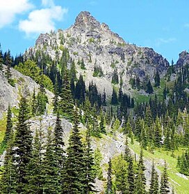
33:Three Way Peak seen from Upper Crystal Lake
18:
158:Location of Three Way Peak in Washington
476:
415:
589:Mountains of Yakima County, Washington
579:Mountains of Pierce County, Washington
178:
145:
302:. It is also on the shared border of
7:
486:
484:
482:
480:
191:Three Way Peak (the United States)
14:
425:Three Way Peak from Sourdough Gap
350:Three Way Peak is located in the
457:
445:
430:
418:
405:Geology of the Pacific Northwest
387:
177:
170:
144:
137:
27:
584:Mountains of Washington (state)
161:Show map of Washington (state)
1:
594:North American 2000 m summits
515:""Threeway Peak" - 6,796' WA"
322:. Its nearest higher peak is
194:Show map of the United States
492:"Three Way Peak, Washington"
49:6,796 ft (2,071 m)
559:Mount Rainier National Park
300:Mount Rainier National Park
237:Mount Rainier National Park
82:0.59 mi (0.95 km)
610:
130:
26:
557:National Park Service:
110:46.908958°N 121.49638°W
59:236 ft (72 m)
115:46.908958; -121.49638
437:Three Way Peak from
318:on the crest of the
233:Protected area
106: /
368:maritime influence
39:Highest point
360:Cascade Mountains
352:marine west coast
293:
292:
601:
545:
542:
529:
528:
526:
525:
511:
500:
499:
488:
461:
449:
434:
422:
397:
395:Mountains portal
392:
391:
390:
324:Crystal Mountain
280:
246:
195:
181:
180:
174:
162:
148:
147:
141:
121:
120:
118:
117:
116:
111:
107:
104:
103:
102:
99:
70:Crystal Mountain
31:
19:
609:
608:
604:
603:
602:
600:
599:
598:
564:
563:
554:
549:
548:
543:
532:
523:
521:
519:listsofjohn.com
513:
512:
503:
490:
489:
478:
473:
468:
465:
462:
453:
450:
441:
435:
426:
423:
413:
401:
400:
393:
388:
386:
381:
364:orographic lift
348:
278:
244:
200:
199:
198:
197:
196:
193:
192:
189:
188:
187:
186:
182:
165:
164:
163:
160:
159:
156:
155:
154:
153:
149:
114:
112:
108:
105:
100:
97:
95:
93:
92:
34:
17:
12:
11:
5:
607:
605:
597:
596:
591:
586:
581:
576:
566:
565:
562:
561:
553:
552:External links
550:
547:
546:
530:
501:
496:Peakbagger.com
475:
474:
472:
469:
467:
466:
463:
456:
454:
451:
444:
442:
436:
429:
427:
424:
417:
414:
412:
409:
408:
407:
399:
398:
383:
382:
380:
377:
356:weather fronts
347:
344:
296:Three Way Peak
291:
290:
282:
274:
273:
269:
268:
260:
254:
253:
248:
240:
239:
234:
230:
229:
224:
220:
219:
214:
210:
209:
206:
202:
201:
190:
185:Three Way Peak
184:
183:
176:
175:
169:
168:
167:
166:
157:
152:Three Way Peak
151:
150:
143:
142:
136:
135:
134:
133:
132:
131:
128:
127:
123:
122:
90:
84:
83:
80:
74:
73:
67:
61:
60:
57:
51:
50:
47:
41:
40:
36:
35:
32:
24:
23:
22:Three Way Peak
15:
13:
10:
9:
6:
4:
3:
2:
606:
595:
592:
590:
587:
585:
582:
580:
577:
575:
574:Cascade Range
572:
571:
569:
560:
556:
555:
551:
541:
539:
537:
535:
531:
520:
516:
510:
508:
506:
502:
497:
493:
487:
485:
483:
481:
477:
470:
460:
455:
448:
443:
440:
433:
428:
421:
416:
410:
406:
403:
402:
396:
385:
378:
376:
373:
369:
365:
361:
357:
353:
345:
343:
341:
337:
333:
329:
325:
321:
320:Cascade Range
317:
313:
309:
308:Yakima County
305:
304:Pierce County
301:
297:
289:
286:
283:
281:
279:Easiest route
275:
270:
267:
264:
261:
259:
255:
252:
249:
247:
241:
238:
235:
231:
228:
225:
221:
218:
215:
211:
208:United States
207:
203:
173:
140:
129:
124:
119:
91:
89:
85:
81:
79:
75:
71:
68:
66:
62:
58:
56:
52:
48:
46:
42:
37:
30:
25:
20:
522:. Retrieved
518:
495:
439:Crystal Peak
349:
340:Naches River
328:Chinook Peak
295:
294:
285:class 2
265:
245:Parent range
464:West aspect
336:White River
316:Cupalo Rock
113: /
101:121°29′47″W
88:Coordinates
65:Parent peak
568:Categories
524:2020-07-09
471:References
312:Washington
288:scrambling
266:Norse Peak
217:Washington
98:46°54′32″N
72:(6,998 ft)
55:Prominence
372:avalanche
126:Geography
78:Isolation
45:Elevation
379:See also
272:Climbing
258:Topo map
251:Cascades
411:Gallery
346:Climate
205:Country
332:runoff
227:Pierce
223:County
213:State
338:and
306:and
263:USGS
310:in
570::
533:^
517:.
504:^
494:.
479:^
342:.
527:.
498:.
Text is available under the Creative Commons Attribution-ShareAlike License. Additional terms may apply.