159:
126:
166:
133:
29:
448:), offers the shortest access to the summit by bypassing the first four miles (6 km) of the Bote Mountain Trail. From the Lead Cove trailhead, it is approximately 7 miles (11 km) to the summit of Thunderhead. The Anthony Creek Trail, rising out of the Cades Cove Picnic Area, also bypasses the first 4 miles (6.4 km) of the Bote Mountain Trail. From the Anthony Creek trailhead, it is approximately 7.5 miles (12 km) to the summit of Thunderhead.
382:
436:
363:
443:
The Bote
Mountain Trail, with its trailhead on Laurel Creek Road, ascends seven miles (11 km) to the crest of the Smokies and intersects the Appalachian Trail at Spence Field. From Spence Field, it is approximately two miles (3 km) to the summit of Thunderhead. The Lead Cove Trail, also
307:
and approximately 3,000 feet (910 m) above its southern base at Bone Valley. The mountain consists of three peaks, the lowest being Rocky Top at 5,440 feet (1,660 m) above sea level and the easternmost being the highest at 5,527 feet (1,685 m) above sea level. Thunderhead is the
319:
The mountain's name originated in the 19th century. It probably referred to the unpredictable weather that often strikes the higher elevations in the
Smokies. According to Laura Thornborough, a writer who hiked to the summit of Thunderhead along with local guide Sam Cook in the 1930s:
324:"As we proceeded in a near-gale to Rocky Top, the first of the three major peaks of Thunderhead, Sam remarked, "It'll be thunderin' and lightnin' on Thunderhead when it's clear on every other peak on top o' Smoky, and that's how it got its name."
400:, a group of East Tennesseans attempted to form a wilderness settlement on the mountain's north slope known as "New World," although the settlement did not last long. The settlement was located along Thunderhead Prong, near Chimney Rocks.
158:
403:
As preservationist groups began buying land in the
Smokies in the early 20th century, Thunderhead became a favorite hiking destination for park visitors. John W. Oliver, the great-grandson of the first European settlers in
337:
sandstone. Thunderhead sandstone is part of the Ocoee
Supergroup, which was formed from ancient ocean sediments between 500 million and one billion years ago. The mountain was formed about 200 million years ago during the
125:
1965:
1990:
895:
393:
1859 survey of the crest of the
Smokies. Guyot measured Thunderhead's elevation at 5,520 feet (1,680 m) above sea level, missing the modern measurement by just seven feet (2 m).
782:
1985:
1285:
1206:
427:. Park strategy at present is to allow Thunderhead to return to its natural state. A narrow path is maintained across the top of the mountain for Appalachian Trail hikers.
2000:
1515:
1715:
1277:
2005:
1281:
291:
crosses its summit, making it a popular hiking destination. Rocky Top, a knob on the western part of the mountain's summit ridge, shares its name with a popular
1970:
1150:
81:
1720:
1261:
1221:
1196:
1155:
775:
511:
1913:
1447:
1097:
374:), was the first known permanent settler in the vicinity. While the extent of Spence's farm is unknown, cattle grazing had rendered Thunderhead a
1011:
1838:
1241:
1980:
1508:
768:
1642:
1316:
991:
791:
502:
420:
1251:
1191:
720:
686:
658:
624:
599:
570:
408:, started offering guided hikes to the mountain in 1924. The trail he (and Thornborough's guide, Sam Cook) used largely followed the
1667:
1231:
1016:
859:
1457:
1437:
1392:
831:
1975:
1501:
1353:
1306:
1301:
1201:
1186:
507:
242:
1738:
1266:
1102:
900:
1890:
1181:
591:
844:
208:
74:
33:
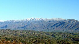
A snow-capped
Thunderhead Mountain of the Great Smoky Mountains range rises above Cades Cove in Blount County, Tennessee
451:
While the main summit of
Thunderhead is covered in foliage, Rocky Top offers a 360-degree view of the western Smokies.
1866:
1311:
1995:
1861:
1833:
1823:
1652:
1376:
276:
28:
1682:
1462:
1256:
1064:
309:
304:
198:
497:
739:
1818:
925:
882:
54:
1579:
943:
272:
230:
1412:
1810:
1782:
1697:
1533:
1402:
1296:
1236:
933:
799:
343:
1801:
1340:
1226:
1087:
339:
1923:
1853:
1597:
1482:
1422:
1363:
1291:
1059:
397:
64:
562:
1571:
1565:
1467:
1432:
1427:
1407:
1397:
1371:
1216:
1120:
1092:
890:
867:
716:
682:
654:
620:
595:
566:
413:
375:
288:
312:
and the highest point on the
Appalachian Trail coming from the south until the trail ascends
1871:
1787:
1748:
1617:
1442:
1112:
1918:
1903:
956:
905:
237:
1348:
1326:
1843:
1766:
1707:
1692:
1662:
1627:
1587:
1542:
1417:
1271:
1171:
1142:
1069:
1041:
1006:
996:
976:
849:
808:
424:
381:
284:
223:
212:
556:
435:
370:
James Spence, who cleared the ridge two miles (3.2 km) to the west (now known as
1959:
1898:
1647:
1637:
1632:
1592:
1452:
1211:
1176:
1051:
1001:
986:
981:
409:
347:
303:
Thunderhead rises approximately 3,500 feet (1,100 m) above its northern base at
1876:
1677:
1657:
1622:
1602:
1321:
1031:
966:
951:
915:
910:
750:
390:
371:
351:
255:
1944:
1828:
1761:
1730:
1672:
1477:
1246:
1132:
1079:
1026:
334:
313:
744:
473:
1908:
1472:
1021:
971:
872:
760:
445:
405:
96:
83:
1612:
1555:
1525:
839:
821:
292:
280:
202:
617:
A Roadside Guide to the
Geology of the Great Smoky Mountains National Park
1939:
1756:
1550:
1493:
1125:
816:
389:
Thunderhead is one of the few mountains listed under its current name in
271:
is a 5,527-foot (1,685 m) mountain in the west-central part of the
531:
362:
1607:
961:
439:
The
Appalachian Trail approaching the summit of Thunderhead Mountain.
423:
was formed, trees began to reclaim much of the Smokies crest west of
44:
434:
380:
361:
316:
5,607 feet (1,709 m) some 10 miles (16 km) to the east.
1497:
764:
755:
681:. Portland, Ore: Graphic Arts Center Publishing. p. 21.
651:
Cades Cove: The Life and Death of An Appalachian Community
672:
670:
262:
Lead Cove Trail, Bote Mountain Trail and Appalachian Trail
715:. Knoxville: University of Tennessee Press. p. 178.
550:
548:
713:
The Great Smokies: From Natural Habitat to National Park
653:. Knoxville: University of Tennessee Press. p. 43.
619:. Knoxville: University of Tennessee Press. p. 32.
366:
Rocky Top, with its characteristic sandstone boulders.
16:
Mountain in the Great Smoky Mountains, United States
1932:
1889:
1852:
1809:
1800:
1775:
1747:
1729:
1706:
1578:
1564:
1541:
1532:
1385:
1362:
1339:
1164:
1141:
1111:
1078:
1050:
942:
924:
881:
858:
830:
807:
798:
254:
249:
236:
222:
191:
112:
73:
63:
53:
43:
38:
21:
287:, the mountain dominates the western Smokies. The
561:. Boston and New York: Houghton-Mifflen. p.
1966:Mountains of Great Smoky Mountains National Park
751:Hiking information for Rocky Top and Thunderhead
474:"Thunderhead Mountain, North Carolina/Tennessee"
1991:Protected areas of Swain County, North Carolina
1276:Rich Mountain, near Boone, Watauga County - 1)
322:
1509:
776:
756:Great Smoky Mountains National Park Landforms
740:Great Smoky Mountains National Park Trail Map
8:
165:
132:
1986:Protected areas of Blount County, Tennessee
385:The view from Rocky Top, looking northwest.
1806:
1538:
1516:
1502:
1494:
804:
783:
769:
761:
18:
2001:Mountains of Swain County, North Carolina
1721:North Carolina-Tennessee-Virginia Corners
1156:North Carolina-Tennessee-Virginia Corners
512:United States Department of the Interior
896:Chestnut Mountain (Transylvania County)
460:
2006:Mountains of Blount County, Tennessee
444:beginning on Laurel Creek Road (near
178:Thunderhead Mountain (North Carolina)
7:
468:
466:
464:
1207:Chestnut Mountain (Caldwell County)
679:Great Smoky Mountains National Park
503:Geographic Names Information System
421:Great Smoky Mountains National Park
1971:Mountains on the Appalachian Trail
279:. Rising along the border between
14:
164:
157:
145:Thunderhead Mountain (Tennessee)
131:
124:
27:
508:United States Geological Survey
532:"Tennessee county high points"
69:Highest point in Blount County
1:
1891:Ridge-and-Valley Appalachians
639:Moore, Harry. 1988 pp. 26-27.
592:University of Tennessee Press
558:The Lure of the Great Smokies
586:Thornborough, Laura (1942).
342:, when the collision of the
49:5,527 ft (1,685 m)
1981:Mountains of North Carolina
792:Mountains of North Carolina
701:Dunn, Durwood. 1988 p. 243.
2022:
416:route still in use today.
378:by the late-19th century.
277:southeastern United States
181:Show map of North Carolina
59:1,087 ft (331 m)
117:
97:35.5685980°N 83.7063208°W
26:
1463:Standing Indian Mountain
1257:Little Chestnut Mountain
1065:North Eaglenest Mountain
333:Thunderhead consists of
310:Blount County, Tennessee
711:Pierce, Daniel (2000).
677:Brewer, Carson (1993).
419:In the years after the
102:35.5685980; -83.7063208
1976:Mountains of Tennessee
1819:Crab Orchard Mountains
1098:Little Yellow Mountain
926:Great Craggy Mountains
883:Great Balsam Mountains
649:Durwood, Dunn (1988).
555:Mason, Robert (1927).
498:"Thunderhead Mountain"
440:
386:
367:
326:
1580:Great Smoky Mountains
944:Great Smoky Mountains
615:Moore, Harry (1988).
588:Great Smoky Mountains
534:. Tennessee Landforms
438:
384:
365:
273:Great Smoky Mountains
231:Great Smoky Mountains
148:Show map of Tennessee
1811:Cumberland Mountains
1783:Little Frog Mountain
1698:Woolly Tops Mountain
1688:Thunderhead Mountain
1534:Blue Ridge Mountains
1448:Occoneechee Mountain
1403:Cane Creek Mountains
1297:Spanish Oak Mountain
1242:Grandmother Mountain
1237:Grandfather Mountain
1037:Thunderhead Mountain
934:Beaucatcher Mountain
800:Blue Ridge Mountains
745:Thunderhead Mountain
293:Tennessee state song
269:Thunderhead Mountain
245:Thunderhead Mountain
172:Thunderhead Mountain
139:Thunderhead Mountain
22:Thunderhead Mountain
1802:Appalachian Plateau
1341:Sauratown Mountains
1227:Fire Scale Mountain
1088:Big Yellow Mountain
340:Appalachian orogeny
93: /
1924:White Oak Mountain
1854:Cumberland Plateau
1683:Sugarland Mountain
1598:Chilhowee Mountain
1483:Whiteside Mountain
1423:Looking Glass Rock
1413:Devil's Courthouse
1364:Uwharrie Mountains
1317:Three Top Mountain
1292:Sassafras Mountain
1286:Rich Mountain Bald
1280:(SSW of Boone) 2)
1060:Eaglenest Mountain
441:
387:
368:
39:Highest point
1996:Appalachian balds
1953:
1952:
1885:
1884:
1796:
1795:
1572:Big Frog Mountain
1566:Cohutta Mountains
1491:
1490:
1468:Terrells Mountain
1433:McAlpine Mountain
1428:Mayfield Mountain
1408:Crowders Mountain
1398:Big Butt Mountain
1372:Caraway Mountains
1335:
1334:
1284:(NW of Boone) 3)
1252:Humpback Mountain
1217:Doe Hill Mountain
1192:Bluerock Mountain
1121:Bob Stratton Bald
1093:Grassy Ridge Bald
891:Black Balsam Knob
868:Hibriten Mountain
414:Appalachian Trail
354:the rock upward.
308:highest point in
289:Appalachian Trail
275:, located in the
266:
265:
2013:
1872:Lookout Mountain
1807:
1788:Holston Mountain
1749:Unicoi Mountains
1618:English Mountain
1539:
1518:
1511:
1504:
1495:
1443:Mulatto Mountain
1232:Flattop Mountain
1113:Unicoi Mountains
860:Brushy Mountains
805:
785:
778:
771:
762:
747:- Peakbagger.com
727:
726:
708:
702:
699:
693:
692:
674:
665:
664:
646:
640:
637:
631:
630:
612:
606:
605:
583:
577:
576:
552:
543:
542:
540:
539:
528:
522:
521:
519:
518:
494:
488:
487:
485:
484:
470:
258:
226:
182:
168:
167:
161:
149:
135:
134:
128:
108:
107:
105:
104:
103:
98:
94:
91:
90:
89:
86:
31:
19:
2021:
2020:
2016:
2015:
2014:
2012:
2011:
2010:
1956:
1955:
1954:
1949:
1928:
1919:Powell Mountain
1904:Clinch Mountain
1881:
1867:Little Mountain
1848:
1792:
1771:
1743:
1725:
1702:
1574:
1560:
1528:
1522:
1492:
1487:
1458:South Mountains
1438:Mount Jefferson
1393:Albert Mountain
1381:
1377:Morrow Mountain
1358:
1331:
1160:
1137:
1107:
1074:
1046:
957:Charlies Bunion
938:
920:
906:Richland Balsam
877:
854:
832:Black Mountains
826:
794:
789:
736:
731:
730:
723:
710:
709:
705:
700:
696:
689:
676:
675:
668:
661:
648:
647:
643:
638:
634:
627:
614:
613:
609:
602:
594:. p. 143.
585:
584:
580:
573:
554:
553:
546:
537:
535:
530:
529:
525:
516:
514:
496:
495:
491:
482:
480:
472:
471:
462:
457:
433:
360:
331:
301:
256:
224:
218:
187:
186:
185:
184:
183:
180:
179:
176:
175:
174:
173:
169:
152:
151:
150:
147:
146:
143:
142:
141:
140:
136:
101:
99:
95:
92:
87:
84:
82:
80:
79:
34:
17:
12:
11:
5:
2019:
2017:
2009:
2008:
2003:
1998:
1993:
1988:
1983:
1978:
1973:
1968:
1958:
1957:
1951:
1950:
1948:
1947:
1942:
1936:
1934:
1930:
1929:
1927:
1926:
1921:
1916:
1914:House Mountain
1911:
1906:
1901:
1895:
1893:
1887:
1886:
1883:
1882:
1880:
1879:
1874:
1869:
1864:
1862:Brown Mountain
1858:
1856:
1850:
1849:
1847:
1846:
1844:Tri-State Peak
1841:
1836:
1831:
1826:
1824:Cross Mountain
1821:
1815:
1813:
1804:
1798:
1797:
1794:
1793:
1791:
1790:
1785:
1779:
1777:
1773:
1772:
1770:
1769:
1767:Starr Mountain
1764:
1759:
1753:
1751:
1745:
1744:
1742:
1741:
1735:
1733:
1727:
1726:
1724:
1723:
1718:
1716:Snake Mountain
1712:
1710:
1708:Iron Mountains
1704:
1703:
1701:
1700:
1695:
1693:Tricorner Knob
1690:
1685:
1680:
1675:
1670:
1665:
1663:Mount Sequoyah
1660:
1655:
1653:Mount Le Conte
1650:
1645:
1640:
1635:
1630:
1628:Mount Cammerer
1625:
1620:
1615:
1610:
1605:
1600:
1595:
1590:
1588:Anakeesta Knob
1584:
1582:
1576:
1575:
1570:
1568:
1562:
1561:
1559:
1558:
1553:
1547:
1545:
1543:Bald Mountains
1536:
1530:
1529:
1523:
1521:
1520:
1513:
1506:
1498:
1489:
1488:
1486:
1485:
1480:
1475:
1470:
1465:
1460:
1455:
1450:
1445:
1440:
1435:
1430:
1425:
1420:
1418:Kings Pinnacle
1415:
1410:
1405:
1400:
1395:
1389:
1387:
1383:
1382:
1380:
1379:
1374:
1368:
1366:
1360:
1359:
1357:
1356:
1354:Pilot Mountain
1351:
1345:
1343:
1337:
1336:
1333:
1332:
1330:
1329:
1324:
1319:
1314:
1309:
1307:Sugar Mountain
1304:
1302:Stone Mountain
1299:
1294:
1289:
1288:(NNW of Boone)
1274:
1272:Pixie Mountain
1269:
1264:
1259:
1254:
1249:
1244:
1239:
1234:
1229:
1224:
1219:
1214:
1209:
1204:
1202:Brown Mountain
1199:
1194:
1189:
1187:Beech Mountain
1184:
1179:
1174:
1172:Adams Mountain
1168:
1166:
1162:
1161:
1159:
1158:
1153:
1151:Snake Mountain
1147:
1145:
1143:Iron Mountains
1139:
1138:
1136:
1135:
1129:
1128:
1123:
1117:
1115:
1109:
1108:
1106:
1105:
1100:
1095:
1090:
1084:
1082:
1076:
1075:
1073:
1072:
1070:Waterrock Knob
1067:
1062:
1056:
1054:
1048:
1047:
1045:
1044:
1042:Tricorner Knob
1039:
1034:
1029:
1024:
1019:
1014:
1012:Mount Sterling
1009:
1007:Mount Sequoyah
1004:
999:
997:Mount Hardison
994:
989:
984:
979:
977:Mount Cammerer
974:
969:
964:
959:
954:
948:
946:
940:
939:
937:
936:
930:
928:
922:
921:
919:
918:
913:
908:
903:
898:
893:
887:
885:
879:
878:
876:
875:
870:
864:
862:
856:
855:
853:
852:
850:Mount Mitchell
847:
842:
836:
834:
828:
827:
825:
824:
819:
813:
811:
809:Bald Mountains
802:
796:
795:
790:
788:
787:
780:
773:
765:
759:
758:
753:
748:
742:
735:
734:External links
732:
729:
728:
722:978-1621901648
721:
703:
694:
688:978-1558681262
687:
666:
660:978-0870495595
659:
641:
632:
626:978-0870495588
625:
607:
601:978-0870490347
600:
578:
572:978-1297505416
571:
544:
523:
489:
478:Peakbagger.com
459:
458:
456:
453:
432:
429:
425:Clingmans Dome
391:Arnold Guyot's
359:
356:
344:North American
330:
327:
300:
297:
285:North Carolina
264:
263:
260:
252:
251:
247:
246:
240:
234:
233:
228:
220:
219:
217:
216:
213:North Carolina
206:
195:
193:
189:
188:
177:
171:
170:
163:
162:
156:
155:
154:
153:
144:
138:
137:
130:
129:
123:
122:
121:
120:
119:
118:
115:
114:
110:
109:
77:
71:
70:
67:
61:
60:
57:
51:
50:
47:
41:
40:
36:
35:
32:
24:
23:
15:
13:
10:
9:
6:
4:
3:
2:
2018:
2007:
2004:
2002:
1999:
1997:
1994:
1992:
1989:
1987:
1984:
1982:
1979:
1977:
1974:
1972:
1969:
1967:
1964:
1963:
1961:
1946:
1943:
1941:
1938:
1937:
1935:
1931:
1925:
1922:
1920:
1917:
1915:
1912:
1910:
1907:
1905:
1902:
1900:
1899:Bays Mountain
1897:
1896:
1894:
1892:
1888:
1878:
1875:
1873:
1870:
1868:
1865:
1863:
1860:
1859:
1857:
1855:
1851:
1845:
1842:
1840:
1839:Pine Mountain
1837:
1835:
1834:Lone Mountain
1832:
1830:
1827:
1825:
1822:
1820:
1817:
1816:
1814:
1812:
1808:
1805:
1803:
1799:
1789:
1786:
1784:
1781:
1780:
1778:
1774:
1768:
1765:
1763:
1760:
1758:
1755:
1754:
1752:
1750:
1746:
1740:
1739:Roan Mountain
1737:
1736:
1734:
1732:
1728:
1722:
1719:
1717:
1714:
1713:
1711:
1709:
1705:
1699:
1696:
1694:
1691:
1689:
1686:
1684:
1681:
1679:
1676:
1674:
1671:
1669:
1666:
1664:
1661:
1659:
1656:
1654:
1651:
1649:
1648:Mount Kephart
1646:
1644:
1641:
1639:
1638:Mount Collins
1636:
1634:
1633:Mount Chapman
1631:
1629:
1626:
1624:
1621:
1619:
1616:
1614:
1611:
1609:
1606:
1604:
1601:
1599:
1596:
1594:
1593:Bote Mountain
1591:
1589:
1586:
1585:
1583:
1581:
1577:
1573:
1569:
1567:
1563:
1557:
1554:
1552:
1549:
1548:
1546:
1544:
1540:
1537:
1535:
1531:
1527:
1524:Mountains of
1519:
1514:
1512:
1507:
1505:
1500:
1499:
1496:
1484:
1481:
1479:
1476:
1474:
1471:
1469:
1466:
1464:
1461:
1459:
1456:
1454:
1453:Old Butt Knob
1451:
1449:
1446:
1444:
1441:
1439:
1436:
1434:
1431:
1429:
1426:
1424:
1421:
1419:
1416:
1414:
1411:
1409:
1406:
1404:
1401:
1399:
1396:
1394:
1391:
1390:
1388:
1384:
1378:
1375:
1373:
1370:
1369:
1367:
1365:
1361:
1355:
1352:
1350:
1347:
1346:
1344:
1342:
1338:
1328:
1325:
1323:
1320:
1318:
1315:
1313:
1310:
1308:
1305:
1303:
1300:
1298:
1295:
1293:
1290:
1287:
1283:
1282:Rich Mountain
1279:
1278:Rich Mountain
1275:
1273:
1270:
1268:
1267:Peak Mountain
1265:
1263:
1260:
1258:
1255:
1253:
1250:
1248:
1245:
1243:
1240:
1238:
1235:
1233:
1230:
1228:
1225:
1223:
1220:
1218:
1215:
1213:
1212:Crossing Knob
1210:
1208:
1205:
1203:
1200:
1198:
1195:
1193:
1190:
1188:
1185:
1183:
1180:
1178:
1175:
1173:
1170:
1169:
1167:
1163:
1157:
1154:
1152:
1149:
1148:
1146:
1144:
1140:
1134:
1131:
1130:
1127:
1124:
1122:
1119:
1118:
1116:
1114:
1110:
1104:
1103:Roan Mountain
1101:
1099:
1096:
1094:
1091:
1089:
1086:
1085:
1083:
1081:
1077:
1071:
1068:
1066:
1063:
1061:
1058:
1057:
1055:
1053:
1052:Plott Balsams
1049:
1043:
1040:
1038:
1035:
1033:
1030:
1028:
1025:
1023:
1020:
1018:
1015:
1013:
1010:
1008:
1005:
1003:
1002:Mount Kephart
1000:
998:
995:
993:
990:
988:
987:Mount Collins
985:
983:
982:Mount Chapman
980:
978:
975:
973:
970:
968:
965:
963:
960:
958:
955:
953:
950:
949:
947:
945:
941:
935:
932:
931:
929:
927:
923:
917:
914:
912:
909:
907:
904:
902:
901:Cold Mountain
899:
897:
894:
892:
889:
888:
886:
884:
880:
874:
871:
869:
866:
865:
863:
861:
857:
851:
848:
846:
843:
841:
838:
837:
835:
833:
829:
823:
820:
818:
815:
814:
812:
810:
806:
803:
801:
797:
793:
786:
781:
779:
774:
772:
767:
766:
763:
757:
754:
752:
749:
746:
743:
741:
738:
737:
733:
724:
718:
714:
707:
704:
698:
695:
690:
684:
680:
673:
671:
667:
662:
656:
652:
645:
642:
636:
633:
628:
622:
618:
611:
608:
603:
597:
593:
590:. Knoxville:
589:
582:
579:
574:
568:
564:
560:
559:
551:
549:
545:
533:
527:
524:
513:
509:
505:
504:
499:
493:
490:
479:
475:
469:
467:
465:
461:
454:
452:
449:
447:
437:
430:
428:
426:
422:
417:
415:
411:
410:Bote Mountain
407:
401:
399:
394:
392:
383:
379:
377:
373:
364:
357:
355:
353:
349:
345:
341:
336:
328:
325:
321:
317:
315:
311:
306:
298:
296:
294:
290:
286:
282:
278:
274:
270:
261:
259:
257:Easiest route
253:
248:
244:
241:
239:
235:
232:
229:
227:
221:
214:
210:
207:
204:
200:
199:Blount County
197:
196:
194:
190:
160:
127:
116:
111:
106:
78:
76:
72:
68:
66:
62:
58:
56:
52:
48:
46:
42:
37:
30:
25:
20:
1877:Walden Ridge
1687:
1678:Spence Field
1658:Mount Mingus
1623:Gregory Bald
1603:Chimney Tops
1349:Moore's Knob
1327:Woody's Knob
1322:Tomkins Knob
1262:Mount Pisgah
1182:Bee Mountain
1036:
1032:Spence Field
967:Gregory Bald
952:Andrews Bald
916:Tanasee Bald
911:Shining Rock
712:
706:
697:
678:
650:
644:
635:
616:
610:
587:
581:
557:
536:. Retrieved
526:
515:. Retrieved
501:
492:
481:. Retrieved
477:
450:
442:
418:
402:
395:
388:
372:Spence Field
369:
332:
323:
318:
305:Little River
302:
268:
267:
225:Parent range
209:Swain County
1945:Penile Hill
1829:Frozen Head
1762:Oswald Dome
1731:Unaka Range
1673:Silers Bald
1643:Mount Guyot
1478:Wesser Bald
1247:Howard Knob
1133:Hooper Bald
1080:Unaka Range
1027:Silers Bald
992:Mount Guyot
845:Mount Craig
396:During the
376:grassy bald
335:Precambrian
314:Silers Bald
299:Description
100: /
75:Coordinates
1960:Categories
1909:Mount Evil
1473:Wayah Bald
1312:Table Rock
1197:Brier Knob
1177:Bear's Paw
1022:Shuckstack
972:Marks Knob
873:Pores Knob
538:2019-07-22
517:2019-07-22
483:2019-07-22
455:References
446:Cades Cove
406:Cades Cove
88:83°42′23″W
85:35°34′07″N
55:Prominence
1668:Old Black
1613:Coon Butt
1556:Max Patch
1526:Tennessee
1017:Old Black
840:Celo Knob
822:Max Patch
398:Civil War
281:Tennessee
203:Tennessee
113:Geography
45:Elevation
1940:Gee Hill
1757:Haw Knob
1551:Big Bald
1222:Elk Knob
1126:Haw Knob
817:Big Bald
250:Climbing
238:Topo map
192:Location
358:History
350:plates
348:African
329:Geology
65:Listing
1933:Others
1776:Others
1608:Kuwohi
1386:Others
1165:Others
962:Kuwohi
719:
685:
657:
623:
598:
569:
431:Access
412:Trail–
352:thrust
215:, U.S.
205:, U.S.
717:ISBN
683:ISBN
655:ISBN
621:ISBN
596:ISBN
567:ISBN
346:and
283:and
243:USGS
1962::
669:^
565:.
563:56
547:^
510:,
506:.
500:.
476:.
463:^
295:.
211:,
201:,
1517:e
1510:t
1503:v
784:e
777:t
770:v
725:.
691:.
663:.
629:.
604:.
575:.
541:.
520:.
486:.
Text is available under the Creative Commons Attribution-ShareAlike License. Additional terms may apply.