138:
178:
145:
171:
469:
457:), causing them to drop their moisture in the form of rain or snowfall onto the Cascades. As a result, the east side of the Cascades experiences less precipitation than the west side of the crest. During winter months, weather is usually cloudy, but due to high pressure systems over the Pacific Ocean that intensify during summer months, there is often little or no cloud cover during the summer.
716:
734:
708:
691:
29:
398:
is significant as the summit rises 3,800 feet (1,200 meters) above the North Fork in 1.3 mile (2.1 km) and 2,200 feet (670 meters) above Conrad Creek in one mile (1.6 km). "Tieton" (
93:
784:
655:
453:
originate in the
Pacific Ocean, and travel northeast toward the Cascade Mountains. As fronts approach, they are forced upward by the peaks of the Cascade Range (
799:
478:
137:
794:
779:
595:
170:
438:
804:
789:
586:
648:
628:
591:
261:
641:
608:
86:
311:
809:
748:
379:
367:
347:
225:
69:
581:
351:
215:
774:
286:
64:
54:
394:, whereas the south slope drains into Conrad Creek which is a tributary of the South Fork Tieton River.
363:
235:
76:
539:
Beckey, Fred W. Cascade Alpine Guide, Climbing and High Routes. Seattle, WA: Mountaineers Books, 2008.
276:
700:
395:
383:
374:
and fifth-highest in Yakima County. Tieton Peak is situated two miles east of the crest of the
304:
473:
437:
word which means "roaring water." The mountain's toponym has been officially adopted by the
401:
454:
256:
743:
434:
387:
242:
768:
450:
375:
292:
249:
678:
391:
326:
299:
633:
510:
483:
371:
108:
95:
727:
28:
554:
343:
44:
382:, 1.75 mi (2.82 km) to the south-southwest. The town of
386:
is 33 mi (53 km) to the east-northeast. Precipitation
637:
422:
416:
410:
535:
533:
531:
425:
419:
407:
404:
390:from the peak's north slope drains into North Fork
325:
320:
310:
298:
285:
275:
270:
255:
241:
231:
221:
211:
203:
124:
85:
75:
63:
53:
43:
38:
21:
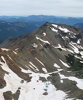
342:is a 7,768-foot-elevation (2,368-meter) mountain
649:
549:
547:
545:
8:
479:List of mountain peaks of Washington (state)
413:
656:
642:
634:
33:Southwest aspect, viewed from Gilbert Peak
18:
596:United States Department of the Interior
370:. It is the fourth-highest point in the
495:
439:United States Board on Geographic Names
785:Mountains of Yakima County, Washington
576:
574:
157:Location of Tieton Peak in Washington
16:Mountain in Washington, United States
7:
800:Stratovolcanoes of the United States
671:
505:
503:
501:
499:
587:Geographic Names Information System
177:
144:
611:Atlas of the North American Indian
14:
732:
714:
706:
689:
467:
400:
176:
169:
143:
136:
27:
795:Volcanoes of Washington (state)
780:Mountains of Washington (state)
592:United States Geological Survey
378:and the nearest higher peak is
190:Tieton Peak (the United States)
664:Places adjacent to Tieton Peak
160:Show map of Washington (state)
1:
805:Stratovolcanoes of Washington
790:North American 2000 m summits
733:
690:
193:Show map of the United States
715:
707:
366:on land administered by the
281:3.2 million - ~500,000 years
49:7,768 ft (2,368 m)
81:1.74 mi (2.80 km)
826:
362:Tieton Peak is set in the
109:46.5120697°N 121.3949614°W
669:
555:"Tieton Peak - 7,768' WA"
511:"Tieton Peak, Washington"
368:Wenatchee National Forest
129:
26:
114:46.5120697; -121.3949614
59:728 ft (222 m)
364:Goat Rocks Wilderness
236:Goat Rocks Wilderness
474:Mountains portal
305:Cascade Volcanic Arc
232:Protected area
105: /
701:Old Snowy Mountain
627:Weather forecast:
396:Topographic relief
316:~500,000 years ago
265:Old Snowy Mountain
39:Highest point
810:Cascade Volcanoes
762:
761:
757:
756:
614:, 2009, p. 387.
337:
336:
817:
736:
735:
718:
717:
710:
709:
693:
692:
672:
658:
651:
644:
635:
615:
606:
600:
599:
578:
569:
568:
566:
565:
551:
540:
537:
526:
525:
523:
521:
507:
472:
471:
470:
432:
431:
428:
427:
424:
421:
418:
415:
412:
409:
406:
329:
245:
194:
180:
179:
173:
161:
147:
146:
140:
120:
119:
117:
116:
115:
110:
106:
103:
102:
101:
98:
31:
19:
825:
824:
820:
819:
818:
816:
815:
814:
765:
764:
763:
758:
719:
665:
662:
624:
619:
618:
607:
603:
580:
579:
572:
563:
561:
559:listsofjohn.com
553:
552:
543:
538:
529:
519:
517:
509:
508:
497:
492:
468:
466:
463:
455:orographic lift
447:
435:Native American
403:
399:
360:
333:Southwest ridge
327:
243:
199:
198:
197:
196:
195:
192:
191:
188:
187:
186:
185:
181:
164:
163:
162:
159:
158:
155:
154:
153:
152:
148:
113:
111:
107:
104:
99:
96:
94:
92:
91:
34:
17:
12:
11:
5:
823:
821:
813:
812:
807:
802:
797:
792:
787:
782:
777:
767:
766:
760:
759:
755:
754:
751:
746:
744:Conrad Glacier
740:
739:
737:
730:
724:
723:
720:
705:
703:
697:
696:
694:
687:
684:
683:
681:
675:
670:
667:
666:
663:
661:
660:
653:
646:
638:
632:
631:
623:
622:External links
620:
617:
616:
609:Carl Waldman,
601:
570:
541:
527:
515:Peakbagger.com
494:
493:
491:
488:
487:
486:
481:
476:
462:
459:
451:weather fronts
446:
443:
359:
356:
335:
334:
331:
323:
322:
318:
317:
314:
308:
307:
302:
296:
295:
289:
283:
282:
279:
273:
272:
268:
267:
259:
253:
252:
247:
239:
238:
233:
229:
228:
223:
219:
218:
213:
209:
208:
205:
201:
200:
189:
183:
182:
175:
174:
168:
167:
166:
165:
156:
150:
149:
142:
141:
135:
134:
133:
132:
131:
130:
127:
126:
122:
121:
89:
83:
82:
79:
73:
72:
67:
61:
60:
57:
51:
50:
47:
41:
40:
36:
35:
32:
24:
23:
15:
13:
10:
9:
6:
4:
3:
2:
822:
811:
808:
806:
803:
801:
798:
796:
793:
791:
788:
786:
783:
781:
778:
776:
775:Cascade Range
773:
772:
770:
752:
750:
747:
745:
742:
741:
738:
731:
729:
726:
725:
721:
713:
704:
702:
699:
698:
695:
688:
686:
685:
682:
680:
676:
674:
673:
668:
659:
654:
652:
647:
645:
640:
639:
636:
630:
626:
625:
621:
613:
612:
605:
602:
597:
593:
589:
588:
583:
582:"Tieton Peak"
577:
575:
571:
560:
556:
550:
548:
546:
542:
536:
534:
532:
528:
516:
512:
506:
504:
502:
500:
496:
489:
485:
482:
480:
477:
475:
465:
464:
460:
458:
456:
452:
444:
442:
440:
436:
430:
397:
393:
389:
385:
381:
377:
376:Cascade Range
373:
369:
365:
357:
355:
353:
349:
348:Yakima County
345:
341:
332:
330:
328:Easiest route
324:
319:
315:
313:
312:Last eruption
309:
306:
303:
301:
297:
294:
293:stratovolcano
290:
288:
287:Mountain type
284:
280:
278:
274:
269:
266:
263:
260:
258:
254:
251:
248:
246:
240:
237:
234:
230:
227:
224:
220:
217:
214:
210:
207:United States
206:
202:
172:
139:
128:
123:
118:
90:
88:
84:
80:
78:
74:
71:
68:
66:
62:
58:
56:
52:
48:
46:
42:
37:
30:
25:
20:
753:Conrad Creek
749:Gilbert Peak
711:
679:Tieton River
610:
604:
585:
562:. Retrieved
558:
520:28 September
518:. Retrieved
514:
448:
392:Tieton River
380:Gilbert Peak
361:
339:
338:
300:Volcanic arc
264:
244:Parent range
70:Gilbert Peak
722:Devils Horn
712:Tieton Peak
677:North Fork
629:Tieton Peak
358:Description
340:Tieton Peak
277:Age of rock
184:Tieton Peak
151:Tieton Peak
112: /
100:121°23′42″W
87:Coordinates
65:Parent peak
22:Tieton Peak
769:Categories
564:2023-09-28
490:References
484:Goat Rocks
372:Goat Rocks
352:Washington
216:Washington
97:46°30′43″N
55:Prominence
728:Ives Peak
125:Geography
77:Isolation
45:Elevation
461:See also
321:Climbing
291:Extinct
257:Topo map
250:Cascades
445:Climate
433:) is a
354:state.
271:Geology
204:Country
388:runoff
384:Tieton
344:summit
226:Yakima
222:County
449:Most
212:State
522:2020
262:USGS
350:of
346:in
771::
594:,
590:.
584:.
573:^
557:.
544:^
530:^
513:.
498:^
441:.
411:aɪ
657:e
650:t
643:v
598:.
567:.
524:.
429:/
426:n
423:ə
420:t
417:ə
414:.
408:t
405:ˈ
402:/
Text is available under the Creative Commons Attribution-ShareAlike License. Additional terms may apply.