863:
73:
923:
904:
281:
928:
783:
64:
offered to place the school further inward the valley towards
Waiomatatini, where it was built and remained there until it closed in the 1970s.
738:
667:
60:
Tikapa Valley was also to be the site of a school in the mid 19th century, to cater for children who were living at Tikapa. However,
49:
On the road heading toward the coast of Tikapa, is a small hilltop cemetery called
Taumata. It is said that this is the place where
141:
842:
897:
827:
274:
57:
by tribal chiefs. One of the chiefs gave away his five daughters to Manuel, and thus produced over 10,000 descendants today.
801:
796:
153:
230:
206:
758:
890:
733:
267:
791:
642:
50:
53:
was buried. He was a
Spanish whaler who in the early part of the 19th century was persuaded to stay in the
723:
361:
217:
107:
806:
547:
346:
318:
299:
837:
748:
718:
702:
743:
592:
482:
811:
647:
542:
487:
381:
341:
331:
687:
677:
607:
870:
862:
832:
497:
492:
472:
326:
290:
174:
27:
874:
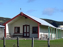
753:
728:
692:
442:
336:
303:
61:
763:
657:
562:
17:
522:
43:
682:
662:
612:
602:
577:
557:
96:
92:
85:
917:
773:
697:
652:
376:
54:
462:
567:
386:
46:. There are several houses still standing, many of which have been left abandoned.
35:
672:
582:
31:
768:
572:
537:
477:
457:
432:
417:
391:
467:
245:
232:
637:
617:
527:
502:
412:
407:
371:
351:
587:
552:
507:
452:
437:
356:
100:
39:
72:
597:
517:
512:
422:
366:
88:
532:
427:
259:
81:
71:
263:
106:
In
October 2020, the Government committed $ 113,765 from the
188:
166:
103:, the Pohatu dining room and Hinekopeka Urupa cemetery.
878:
154:"Spanish royals invited to Manuel Jose family reunion"
110:
to upgrade the marae, creating an estimate 5.5 jobs.
80:
Tikapa Marae, located on a hill in the area, is the
42:. In 1952 the community numbered 156, predominantly
820:
782:
711:
630:
400:
317:
310:
142:"Paniora go back to source of their Spanish roots"
156:, Murray Robertson, Nov 26, 2015, Gisborne herald
898:
275:
8:
905:
891:
314:
282:
268:
260:
99:. It includes the late 19th century Pōkai
924:Populated places in the Gisborne District
119:
76:Pokai meetinghouse, Tikapa, New Zealand
16:For the bay in the Hauraki Gulf, see
7:
859:
857:
34:. It is on the southern side of the
877:. You can help Knowledge (XXG) by
144:, Aug 14, 2012, Rotarua Daily Post
127:Dollimore, Edward Stewart (1952).
14:
929:Gisborne District geography stubs
873:-related geography article is a
861:
1:
26:is a rural community in the
802:Gisborne Girls' High School
759:Raukumara Conservation Park
195:. Te Potiki National Trust.
167:"Te Kāhui Māngai directory"
945:
856:
797:Gisborne Boys' High School
734:Gisborne Botanical Gardens
712:Facilities and attractions
15:
838:Gisborne Thistle Football
769:Te Urewera protected area
643:Whangaokeno / East Island
297:
739:Gisborne Railway Station
131:. H. Wise. p. 732.
833:Gisborne City Football
724:Eastwoodhill Arboretum
218:Provincial Growth Fund
108:Provincial Growth Fund
77:
807:Gisborne Intermediate
401:Towns and rural areas
246:37.79928°S 178.4428°E
207:"Marae Announcements"
129:The New Zealand Guide
75:
749:Harry Barker Reserve
719:East Cape Lighthouse
93:Te Whānau a Hineauta
744:Hackfalls Arboretum
631:Geographic features
251:-37.79928; 178.4428
242: /
214:growregions.govt.nz
38:mouth and north of
812:Lytton High School
648:Gable End Foreland
543:Gable End Foreland
78:
886:
885:
871:Gisborne District
851:
850:
843:Poverty Bay Rugby
703:Young Nick's Head
626:
625:
291:Gisborne District
220:. 9 October 2020.
97:Te Whānau a Pōkai
62:Sir Āpirana Ngata
936:
907:
900:
893:
865:
858:
828:East Coast Rugby
754:Mangahanea Marae
729:Gisborne Airport
337:Gisborne Central
315:
311:Populated places
304:Gisborne Central
284:
277:
270:
261:
257:
256:
254:
253:
252:
247:
243:
240:
239:
238:
235:
222:
221:
211:
203:
197:
196:
185:
179:
178:
163:
157:
151:
145:
139:
133:
132:
124:
944:
943:
939:
938:
937:
935:
934:
933:
914:
913:
912:
911:
854:
852:
847:
816:
792:Campion College
778:
764:Te Puia Springs
707:
688:Raukūmara Range
678:Mount Raukūmara
668:Mount Hikurangi
658:Motuoroi Island
622:
563:Te Puia Springs
396:
306:
293:
288:
250:
248:
244:
241:
236:
233:
231:
229:
228:
226:
225:
209:
205:
204:
200:
187:
186:
182:
165:
164:
160:
152:
148:
140:
136:
126:
125:
121:
116:
70:
28:Gisborne Region
21:
18:Firth of Thames
12:
11:
5:
942:
940:
932:
931:
926:
916:
915:
910:
909:
902:
895:
887:
884:
883:
866:
849:
848:
846:
845:
840:
835:
830:
824:
822:
818:
817:
815:
814:
809:
804:
799:
794:
788:
786:
780:
779:
777:
776:
771:
766:
761:
756:
751:
746:
741:
736:
731:
726:
721:
715:
713:
709:
708:
706:
705:
700:
695:
693:Titirangi Hill
690:
685:
683:Pourewa Island
680:
675:
670:
665:
663:Mount Arowhana
660:
655:
650:
645:
640:
634:
632:
628:
627:
624:
623:
621:
620:
615:
610:
605:
600:
595:
590:
585:
580:
578:Waimata Valley
575:
570:
565:
560:
558:Pourewa Island
555:
550:
545:
540:
535:
530:
525:
520:
515:
510:
505:
500:
495:
490:
485:
480:
475:
470:
465:
460:
455:
450:
445:
440:
435:
430:
425:
420:
415:
410:
404:
402:
398:
397:
395:
394:
389:
384:
379:
374:
369:
364:
359:
354:
349:
344:
339:
334:
329:
323:
321:
312:
308:
307:
298:
295:
294:
289:
287:
286:
279:
272:
264:
224:
223:
198:
180:
175:Te Puni Kōkiri
158:
146:
134:
118:
117:
115:
112:
69:
66:
13:
10:
9:
6:
4:
3:
2:
941:
930:
927:
925:
922:
921:
919:
908:
903:
901:
896:
894:
889:
888:
882:
880:
876:
872:
867:
864:
860:
855:
844:
841:
839:
836:
834:
831:
829:
826:
825:
823:
819:
813:
810:
808:
805:
803:
800:
798:
795:
793:
790:
789:
787:
785:
781:
775:
774:Whakarua Park
772:
770:
767:
765:
762:
760:
757:
755:
752:
750:
747:
745:
742:
740:
737:
735:
732:
730:
727:
725:
722:
720:
717:
716:
714:
710:
704:
701:
699:
698:Tuaheni Point
696:
694:
691:
689:
686:
684:
681:
679:
676:
674:
671:
669:
666:
664:
661:
659:
656:
654:
653:Huiarau Range
651:
649:
646:
644:
641:
639:
636:
635:
633:
629:
619:
616:
614:
611:
609:
606:
604:
601:
599:
596:
594:
591:
589:
586:
584:
581:
579:
576:
574:
571:
569:
566:
564:
561:
559:
556:
554:
551:
549:
546:
544:
541:
539:
536:
534:
531:
529:
526:
524:
521:
519:
516:
514:
511:
509:
506:
504:
501:
499:
496:
494:
491:
489:
486:
484:
481:
479:
476:
474:
471:
469:
466:
464:
461:
459:
456:
454:
451:
449:
446:
444:
441:
439:
436:
434:
431:
429:
426:
424:
421:
419:
416:
414:
411:
409:
406:
405:
403:
399:
393:
390:
388:
385:
383:
380:
378:
377:Tuaheni Point
375:
373:
370:
368:
365:
363:
360:
358:
355:
353:
350:
348:
345:
343:
340:
338:
335:
333:
330:
328:
325:
324:
322:
320:
319:Gisborne City
316:
313:
309:
305:
301:
296:
292:
285:
280:
278:
273:
271:
266:
265:
262:
258:
255:
219:
215:
208:
202:
199:
194:
193:maorimaps.com
190:
184:
181:
176:
172:
168:
162:
159:
155:
150:
147:
143:
138:
135:
130:
123:
120:
113:
111:
109:
104:
102:
101:meeting house
98:
94:
90:
87:
83:
82:meeting place
74:
67:
65:
63:
58:
56:
55:Waiapu Valley
52:
47:
45:
41:
37:
33:
29:
25:
19:
879:expanding it
868:
853:
568:Tokomaru Bay
447:
387:Wainui Beach
227:
213:
201:
192:
189:"Māori Maps"
183:
170:
161:
149:
137:
128:
122:
105:
79:
59:
48:
36:Waiapu River
23:
22:
673:Maungahaumi
583:Waipiro Bay
249: /
237:178°26′34″E
171:tkm.govt.nz
86:Ngāti Porou
51:Manuel José
32:New Zealand
918:Categories
608:Matokitoki
573:Tolaga Bay
548:Kaiaua Bay
538:Anaura Bay
458:Whareponga
433:Rangitukia
418:Hiruharama
392:Whataupoko
234:37°47′57″S
114:References
638:East Cape
618:Waihirere
528:Whatatutu
523:Wharerātā
503:Te Karaka
443:Te Araroa
413:Hicks Bay
408:East Cape
372:Te Hapara
362:Riverdale
352:Mangapapa
613:Pātūtahi
603:Manutūkē
588:Whangara
553:Makarika
508:Tiniroto
453:Tikitiki
438:Ruatoria
382:Victoria
347:Makaraka
40:Ruatoria
784:Schools
598:Makauri
518:Waituhi
513:Waikohu
478:Ngātapa
473:Muriwai
463:Mātāwai
423:Horoera
367:Tamarau
327:Awapuni
210:(Excel)
84:of the
821:Sports
593:Hexton
533:Akuaku
483:Ormond
448:Tikapa
428:Potaka
24:Tikapa
869:This
488:Otoko
357:Okitū
342:Kaiti
332:Elgin
68:Marae
44:Māori
875:stub
498:Rere
493:Puha
468:Mōtū
300:Seat
95:and
89:hapū
91:of
30:of
920::
302::
216:.
212:.
191:.
173:.
169:.
906:e
899:t
892:v
881:.
283:e
276:t
269:v
177:.
20:.
Text is available under the Creative Commons Attribution-ShareAlike License. Additional terms may apply.