87:
57:
94:
64:
36:
344:
358:
are more common here, making Tioga Lake and its surroundings popular with bird watchers. Because of the altitude and its location at the crest of a major pass, the weather is extremely unpredictable. Frost is even possible in July.
354:
Because of its inaccessibility, the region and Tioga Lake itself are popular with campers who want to avoid the crowds of
Yosemite, photographers, anglers, and nature lovers in general.
328:
The lake offers trout fishing, a picnic area, and a 13-site managed campground. Some of the wildlife in the area are brave enough to approach humans, especially birds and
137:
456:
451:
86:
466:
56:
431:
20:
416:
388:
446:
461:
368:
273:
241:
261:
123:
304:, is the namesake for the lake. The area is believed to have been settled as early as 10,000 years ago by
301:
269:
181:
277:
257:
119:
305:
426:
193:
392:
440:
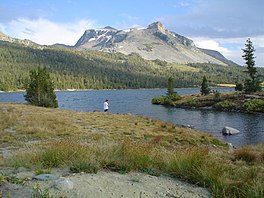
355:
337:
312:
was among the first
Americans to see the area. The next major interest came from the
199:
169:
253:
174:
348:
281:
265:
41:
35:
152:
139:
309:
421:
297:
292:
Unlike most passes through the Sierra which are named for an individual,
343:
317:
242:
U.S. Geological Survey
Geographic Names Information System: Tioga Lake
182:
333:
329:
313:
342:
19:
For the lake in the sub-Antarctic South Orkney
Islands, see
340:
can be seen, although the latter are particularly shy.
300:word, meaning "where it forks" or "swift current".
237:
233:
225:
217:
209:
205:
192:
180:
168:
129:
115:
28:
130:
16:Lake in the state of California, United States
8:
264:, about two miles (3 km) north of the
25:
427:LandscapePhoto.us Sierra Nevada Gallery
380:
347:Tioga Lake in spring looking towards
7:
391:. Tioga Pass Resort. Archived from
457:Glacial lakes of the United States
93:
63:
14:
21:Tioga Lake (South Orkney Islands)
452:Lakes of Mono County, California
92:
85:
62:
55:
34:
224:
216:
208:
1:
114:
106:Show map of the United States
467:Lakes of Northern California
432:GORP's Hiking Mono Lake Area
272:. The lake bed is alongside
229:9,638 ft (2,938 m)
389:"Tioga Pass Resort History"
369:List of lakes in California
221:0.25 mi (0.40 km)
213:0.65 mi (1.05 km)
483:
18:
49:
33:
262:Mono County, California
124:Mono County, California
40:An angler at the lake,
351:
302:Tioga County, New York
270:Yosemite National Park
76:Show map of California
346:
447:Inyo National Forest
422:Inyo National Forest
258:Inyo National Forest
153:37.9241°N 119.2519°W
120:Inyo National Forest
462:Lakes of California
149: /
352:
306:indigenous peoples
158:37.9241; -119.2519
332:. Occasionally a
247:
246:
226:Surface elevation
44:in the background
474:
404:
403:
401:
400:
385:
188:Lee Vining Creek
184:
183:Primary outflows
164:
163:
161:
160:
159:
154:
150:
147:
146:
145:
142:
132:
107:
96:
95:
89:
77:
66:
65:
59:
38:
26:
482:
481:
477:
476:
475:
473:
472:
471:
437:
436:
413:
408:
407:
398:
396:
387:
386:
382:
377:
365:
326:
290:
274:State Route 120
196: countries
157:
155:
151:
148:
143:
140:
138:
136:
135:
122:
111:
110:
109:
108:
105:
104:
103:
102:
101:
97:
80:
79:
78:
75:
74:
73:
72:
71:
67:
45:
24:
17:
12:
11:
5:
480:
478:
470:
469:
464:
459:
454:
449:
439:
438:
435:
434:
429:
424:
419:
412:
411:External links
409:
406:
405:
379:
378:
376:
373:
372:
371:
364:
361:
325:
322:
289:
286:
245:
244:
239:
235:
234:
231:
230:
227:
223:
222:
219:
215:
214:
211:
207:
206:
203:
202:
197:
190:
189:
186:
178:
177:
172:
166:
165:
133:
127:
126:
117:
113:
112:
99:
98:
91:
90:
84:
83:
82:
81:
69:
68:
61:
60:
54:
53:
52:
51:
50:
47:
46:
39:
31:
30:
15:
13:
10:
9:
6:
4:
3:
2:
479:
468:
465:
463:
460:
458:
455:
453:
450:
448:
445:
444:
442:
433:
430:
428:
425:
423:
420:
418:
415:
414:
410:
395:on 2007-09-28
394:
390:
384:
381:
374:
370:
367:
366:
362:
360:
357:
356:Birds of prey
350:
345:
341:
339:
338:bighorn sheep
335:
331:
323:
321:
319:
315:
311:
307:
303:
299:
295:
287:
285:
283:
279:
278:Sierra Nevada
275:
271:
267:
263:
259:
255:
251:
243:
240:
236:
232:
228:
220:
212:
204:
201:
200:United States
198:
195:
191:
187:
185:
179:
176:
173:
171:
167:
162:
134:
128:
125:
121:
118:
88:
58:
48:
43:
37:
32:
27:
22:
397:. Retrieved
393:the original
383:
353:
327:
320:industries.
293:
291:
268:entrance to
254:glacial lake
249:
248:
175:glacial lake
252:is a small
210:Max. length
156: /
144:119°15′07″W
131:Coordinates
441:Categories
417:Tioga Lake
399:2008-03-14
375:References
349:Tioga Pass
324:Recreation
282:California
266:Tioga Pass
250:Tioga Lake
238:References
218:Max. width
141:37°55′27″N
100:Tioga Lake
70:Tioga Lake
42:Mount Dana
29:Tioga Lake
310:John Muir
363:See also
298:Iroquois
116:Location
330:marmots
318:logging
288:History
276:in the
256:in the
334:bobcat
314:mining
296:is an
294:tioga
194:Basin
316:and
170:Type
336:or
280:of
260:of
443::
308:.
284:.
402:.
23:.
Text is available under the Creative Commons Attribution-ShareAlike License. Additional terms may apply.