93:
106:
27:
113:
361:
A water treatment plant was built immediately below the reservoir, with the treated water being stored in a 10 gallon underground reservoir at the site, before being distributed to other service reservoirs at
Birches Head and Bucknall. An effluent treatment plant was also constructed below the
358:. c. xl). Although authorised in 1949, the decision to proceed with the extension was only made in 1957. Work started in May 1959 and was completed in 1963. Nine properties in the village of Meerbrook were flooded by the extended reservoir, including The Fountain Inn.
335:
The reservoir was built by the
Staffordshire Potteries Waterworks Company in 1858, as a compensation reservoir to regulate the flow of water in the River Churnet, which was used by several mills downstream. This was required by the
347:
On 1 January 1925, the reservoir, together with the rest of the undertakings of the private
Staffordshire Potteries Waterworks Company passed to the new, public, Staffordshire Potteries Water Board.
105:
423:
337:
492:
497:
148:
398:
Baggs, A. P.; Cleverdon, M. F.; Johnston, D. A.; Tringham, N. J. (1996). "Leek: Tittesworth". In Currie, C. R. J.; Greenslade, M. W. (eds.).
507:
48:
365:
The
Staffordshire Potteries Water Board, and with it Tittesworth Reservoir, became part of the new Severn Trent Water Authority in 1974.
374:
446:
70:
351:
502:
362:
dam, to treat the effluent from the
William Tatton dying works of at Upper Hulme Mill, which were piped around the reservoir.
378:
344:
cxcviii). Supply water was extracted, naturally filtered, from underground sources, not from the river or reservoir.
41:
35:
471:
52:
268:
92:
258:
206:
355:
304:
465:
417:
324:
223:
192:
442:
287:
399:
341:
350:
The reservoir was extended by the
Staffordshire Potteries Water Board, under powers in the
320:
486:
316:
308:
213:
199:
134:
163:
150:
300:
185:
439:
Peak
District Boundary Walk: 190 Miles Around the Edge of the National Park
338:
Staffordshire
Potteries Waterworks Consolidation and Extension Act 1853
312:
193:
207:
180:
404:. Vol. 7: Leek and the Moorlands. London. pp. 232–239
20:
377:
277:
267:
257:
249:
241:
237:
229:
219:
205:
191:
179:
140:
130:
85:
141:
112:
8:
352:Staffordshire Potteries Water Board Act 1949
422:: CS1 maint: location missing publisher (
82:
71:Learn how and when to remove this message
34:This article includes a list of general
390:
415:
16:A reservoir in Staffordshire, England
7:
412:– via British History Online.
401:A History of the County of Stafford
40:it lacks sufficient corresponding
14:
273:6,440,000m³ (1.4 billion gallons)
263:760,000 square metres (190 acres)
493:Nature reserves in Staffordshire
472:"The Flooded Properties project"
441:. Friends of the Peak District.
323:works are owned and operated by
111:
104:
91:
25:
498:Reservoirs of the Peak District
319:. The reservoir and associated
276:
266:
256:
248:
240:
1:
253:0.6 kilometres (0.37 mi)
129:
281:6.6 kilometres (4.1 mi)
245:1.8 kilometres (1.1 mi)
508:Reservoirs in Staffordshire
379:Peak District Boundary Walk
524:
288:not a well-defined measure
381:runs past the reservoir.
285:
99:
90:
503:Staffordshire Moorlands
437:McCloy, Andrew (2017).
55:more precise citations.
356:12, 13 & 14 Geo. 6
476:Leekfrith Bygone Days
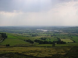
297:Tittesworth Reservoir
119:Tittesworth Reservoir
86:Tittesworth Reservoir
373:Tittesworth is the
299:is a water storage
160: /
325:Severn Trent Water
224:Severn Trent Water
342:16 & 17 Vict.
294:
293:
81:
80:
73:
515:
479:
453:
452:
434:
428:
427:
421:
413:
411:
409:
395:
286:Shore length is
209:
208:Primary outflows
195:
175:
174:
172:
171:
170:
165:
164:53.134°N 2.013°W
161:
158:
157:
156:
153:
143:
115:
114:
108:
95:
83:
76:
69:
65:
62:
56:
51:this article by
42:inline citations
29:
28:
21:
523:
522:
518:
517:
516:
514:
513:
512:
483:
482:
470:
462:
457:
456:
449:
436:
435:
431:
414:
407:
405:
397:
396:
392:
387:
371:
333:
321:water treatment
220:Managing agency
194:Primary inflows
168:
166:
162:
159:
154:
151:
149:
147:
146:
126:
125:
124:
123:
122:
121:
120:
116:
77:
66:
60:
57:
47:Please help to
46:
30:
26:
17:
12:
11:
5:
521:
519:
511:
510:
505:
500:
495:
485:
484:
481:
480:
468:
461:
460:External links
458:
455:
454:
448:978-1909461536
447:
429:
389:
388:
386:
383:
375:second largest
370:
367:
332:
329:
292:
291:
283:
282:
279:
275:
274:
271:
265:
264:
261:
255:
254:
251:
247:
246:
243:
239:
238:
235:
234:
231:
227:
226:
221:
217:
216:
211:
203:
202:
197:
189:
188:
183:
177:
176:
169:53.134; -2.013
144:
138:
137:
132:
128:
127:
118:
117:
110:
109:
103:
102:
101:
100:
97:
96:
88:
87:
79:
78:
61:September 2016
33:
31:
24:
15:
13:
10:
9:
6:
4:
3:
2:
520:
509:
506:
504:
501:
499:
496:
494:
491:
490:
488:
477:
473:
469:
467:
466:Official Site
464:
463:
459:
450:
444:
440:
433:
430:
425:
419:
403:
402:
394:
391:
384:
382:
380:
376:
368:
366:
363:
359:
357:
353:
348:
345:
343:
339:
330:
328:
326:
322:
318:
317:River Churnet
315:, fed by the
314:
310:
309:Staffordshire
306:
302:
298:
289:
284:
280:
272:
270:
262:
260:
252:
244:
236:
232:
228:
225:
222:
218:
215:
214:River Churnet
212:
210:
204:
201:
200:River Churnet
198:
196:
190:
187:
184:
182:
178:
173:
145:
139:
136:
135:Staffordshire
133:
107:
98:
94:
89:
84:
75:
72:
64:
54:
50:
44:
43:
37:
32:
23:
22:
19:
475:
438:
432:
406:. Retrieved
400:
393:
372:
364:
360:
349:
346:
334:
296:
295:
278:Shore length
269:Water volume
259:Surface area
67:
58:
39:
18:
408:18 December
242:Max. length
167: /
142:Coordinates
53:introducing
487:Categories
385:References
250:Max. width
152:53°08′02″N
36:references
418:cite book
369:Reservoir
301:reservoir
186:reservoir
181:Lake type
155:2°00′47″W
131:Location
331:History
313:England
49:improve
445:
38:, but
303:near
230:Built
443:ISBN
424:link
410:2015
305:Leek
233:1963
489::
474:.
420:}}
416:{{
327:.
311:,
307:,
478:.
451:.
426:)
354:(
340:(
290:.
74:)
68:(
63:)
59:(
45:.
Text is available under the Creative Commons Attribution-ShareAlike License. Additional terms may apply.