54:
47:
291:
299:
614:. A pinnacle-type mountain 2,900 metres (9,500 ft) high which forms the south end of Pain Mesa and the north side of the entrance to Pinnacle Gap. Mapped by USGS from surveys and United States Navy air photos, 1960–64. Named by US-ACAN for Commander Justin G. Ballou, United States Navy, officer in charge of the Detachment A winter party at McMurdo Station, 1966.
1401:
1366:
534:. An ice-filled valley indenting the east side of Pain Mesa between Biretta Peak and Diversion Hills. Mapped by USGS from surveys and United States Navy air photos, 1960–64. Named by US-ACAN for Commander Norman J. Mills, United States Navy Reserve, officer in charge of the Detachment A winter party at McMurdo Station, 1967.
896:. An ice-free mountain, 2,670 metres (8,760 ft) high, marking the southwest end of Tobin Mesa. Mapped by USGS from surveys and United States Navy air photos, 1960–64. Named by US-ACAN for William Z. Fazio, United States Navy, helicopter crewmember during United States Navy OpDFrz, 1966, 1967 and 1968.
690:. A bold rock bluff that forms the northwest end of Tobin Mesa. The bluff exposes an easily accessible section of Jurassic basalt. The feature was studied by Ohio State University geological parties in 1981–82 and 1982–83. Named by US-ACAN after Mary A. Siders, geologist in those field parties.
816:. A prominent peak, 3,160 metres (10,370 ft) high, located 2 nautical miles (3.7 km; 2.3 mi) northeast of Mount Frustum in the southeast end of Tobin Mesa. Named by the northern party of the NZGSAE, 1962–63, for its resemblance to a scarab beetle.
698:{{coord|73|15|S|163WE A gap between Pain and Tobin Mesas. The feature was traversed and so named by the northern party of NZGSAE, 1962-63, because it is readily identified by the high rock pinnacle (Mount Ballou) on the north ridge overlooking the gap.
336:. A prominent mesa standing 10 nautical miles (19 km; 12 mi) west-northwest of Pain Mesa in the northwest part of Mesa Range. Named by the northern party of NZGSAE, 1962–63, for Maurice Sheehan, field assistant with this party.
1405:
1370:
496:. A small peak 2,530 metres (8,300 ft) high on the east side of Pain Mesa. Named by the northern party of NZGSAE, 1962–63, from its resemblance to the square cap worn by Roman Catholic and some Anglican clerics.
854:. A large pyramidal shaped table mountain, 3,100 metres (10,200 ft) high, standing between Mount Fazio and Scarab Peak in the south part of Tobin Mesa. Named by the northern party of NZGSAE, 1962–63, for its
374:. A ridge leading to the top of Sheehan Mesa, on the northeast side. Large silicified tree stumps in place of growth were found halfway up this ridge, hence named Silva by the Northern Party of NZGSAE, 1962–63.
450:. A prominent flat-topped summit, 2,605 metres (8,547 ft) high, in the narrow, northern part of Pain Mesa, situated 11 nautical miles (20 km; 13 mi) east of Silva Ridge. Mapped by the
736:. A small, pointed hill at the southeast side of Pinnacle Gap. So named by the northern party of NZGSAE, 1962–63, because the feature provides a good "watchtower" to the entrance of Pinnacle Gap.
774:. A bold rock spur 3 nautical miles (5.6 km; 3.5 mi) north of Scarab Peak, extending northeast from the east central part of Tobin Mesa. The feature was geologically studied by an
572:. A small group of low rock outcrops at the east extremity of Pain Mesa. Named by the southern party of NZGSAE, 1966–67, because the party diverted eastward from their route here to visit
1018:. A low hill at the southwest end of Gair Mesa. So named by the northern party of NZGSAE, 1962–63, because the west side of the hill has a noteworthy exposure of light colored sandstone.
652:. A large mesa in the Mesa Range, between Pain Mesa on the north and Gair Mesa on the south. Named by the Northern Party of NZGSAE, 1962–63, for James Tobin, surveyor with this party.
208:
980:. Named "Veto" by the northern party of NZGSAE, 1962–63, because it decided that Pinnacle Gap to the north offered the better route from Rennick to Aviator Glacier.
412:. A large mesa just north of Tobin Mesa in the Mesa Range. Named by the northern party of NZGSAE, 1962–63, for Kevin Pain, deputy leader of this party.
1424:
1060:. Named by the northern party of NZGSAE, 1962–63, because of a dog fight here in which one dog was so badly torn that its wounds required sutures.
1374:
109:
934:. The southernmost mesa of the Mesa Range. Named by the northern party of NZGSAE, 1962–63, for Harry Gair, geologist and leader of this party.
46:
455:
158:
1409:
451:
102:
1028:
990:
944:
906:
868:
826:
788:
746:
708:
662:
624:
586:
544:
506:
468:
422:
384:
346:
308:
252:
1429:
778:
field party during the 1982–83 season. Named by US-ACAN after Marta A. Haban, a geologist in the party.
232:
775:
290:
298:
239:
to the northeast, the
Southern Cross Mountains to the east, and the Deep Freeze Range to the south.
458:(US-ACAN) for Andrew J. Masley, ionospheric physics scientist at McMurdo Station, summer 1962–63.
279:
228:
274:
573:
224:
1057:
977:
454:(USGS) from surveys and United States Navy air photos, 1960–64. Named by the United States
1381:
269:
236:
973:
220:
200:
1056:. A bench-like elevation at the southeast end of Gair Mesa that overlooks the head of
1418:
204:
91:
1347:
199:
comprising the
Sheehan, Pain, Tobin and Gair Mesas, situated at the head of the
219:
The Gair, Tobin and Pain mesas are in the east side of the middle reach of the
207:, Antarctica. It was given this descriptive name by the northern party of the
95:
81:
1043:
1030:
1005:
992:
959:
946:
921:
908:
883:
870:
841:
828:
803:
790:
761:
748:
723:
710:
677:
664:
639:
626:
601:
588:
559:
546:
521:
508:
483:
470:
437:
424:
399:
386:
361:
348:
323:
310:
174:
160:
125:
111:
264:
17:
972:. A gap between Tobin and Gair Mesas which provides access from upper
855:
297:
289:
196:
1355:(2 ed.), United States Board on Geographic Names
101:
87:
77:
72:
34:
209:New Zealand Geological Survey Antarctic Expedition
1088:
223:, and the Sheehan Mesa is on the west side. The
8:
31:
1375:United States Board on Geographic Names
1328:
1316:
1304:
1292:
1280:
1268:
1256:
1244:
1232:
1220:
1208:
1196:
1184:
1172:
1160:
1148:
1136:
1124:
1112:
1100:
1076:
1069:
1386:, USGS: United States Geographic Board
456:Advisory Committee on Antarctic Names
7:
1408:from websites or documents of the
1373:from websites or documents of the
53:
25:
1349:Geographic Names of the Antarctic
1425:Mountain ranges of Victoria Land
1404: This article incorporates
1399:
1369: This article incorporates
1364:
52:
45:
1410:United States Geological Survey
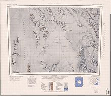
452:United States Geological Survey
1346:Alberts, Fred G., ed. (1995),
1:
195:) is a range of flat-topped
280:GPX (secondary coordinates)
1446:
227:are to the northwest, the
275:GPX (primary coordinates)
250:Map all coordinates using
39:
258:Download coordinates as:
302:Mesa Range in northwest
294:Mesa Range in southwest
1406:public domain material
1371:public domain material
303:
295:
776:Ohio State University
301:
293:
270:GPX (all coordinates)
211:(NZGSAE) of 1962–63.
1089:Mount Murchison USGS
1040: /
1002: /
956: /
918: /
880: /
838: /
800: /
758: /
720: /
674: /
636: /
598: /
556: /
518: /
480: /
434: /
396: /
358: /
320: /
170: /
121: /
27:Mesas in Antarctica
1044:73.517°S 162.950°E
1006:73.533°S 162.717°E
960:73.400°S 162.900°E
922:73.467°S 162.867°E
884:73.383°S 162.800°E
842:73.383°S 162.917°E
804:73.350°S 163.017°E
762:73.300°S 163.000°E
724:73.267°S 163.133°E
678:73.217°S 162.667°E
640:73.283°S 162.867°E
602:73.233°S 163.050°E
560:73.150°S 163.500°E
522:73.100°S 163.200°E
484:73.067°S 163.200°E
438:72.983°S 162.900°E
400:73.133°S 163.000°E
362:72.983°S 162.283°E
324:73.017°S 162.300°E
304:
296:
229:Freyberg Mountains
175:73.183°S 162.917°E
126:73.183°S 162.917°E
574:Navigator Nunatak
225:Monument Nunataks
149:
148:
103:Range coordinates
16:(Redirected from
1437:
1403:
1402:
1394:
1393:
1391:
1368:
1367:
1363:
1362:
1360:
1354:
1332:
1326:
1320:
1314:
1308:
1302:
1296:
1290:
1284:
1278:
1272:
1266:
1260:
1254:
1248:
1242:
1236:
1230:
1224:
1218:
1212:
1206:
1200:
1194:
1188:
1182:
1176:
1170:
1164:
1158:
1152:
1146:
1140:
1134:
1128:
1122:
1116:
1110:
1104:
1098:
1092:
1086:
1080:
1074:
1058:Campbell Glacier
1055:
1054:
1052:
1051:
1050:
1049:-73.517; 162.950
1045:
1041:
1038:
1037:
1036:
1033:
1017:
1016:
1014:
1013:
1012:
1011:-73.533; 162.717
1007:
1003:
1000:
999:
998:
995:
978:Aeronaut Glacier
971:
970:
968:
967:
966:
965:-73.400; 162.900
961:
957:
954:
953:
952:
949:
933:
932:
930:
929:
928:
927:-73.467; 162.867
923:
919:
916:
915:
914:
911:
895:
894:
892:
891:
890:
889:-73.383; 162.800
885:
881:
878:
877:
876:
873:
853:
852:
850:
849:
848:
847:-73.383; 162.917
843:
839:
836:
835:
834:
831:
815:
814:
812:
811:
810:
809:-73.350; 163.017
805:
801:
798:
797:
796:
793:
773:
772:
770:
769:
768:
767:-73.300; 163.000
763:
759:
756:
755:
754:
751:
735:
734:
732:
731:
730:
729:-73.267; 163.133
725:
721:
718:
717:
716:
713:
689:
688:
686:
685:
684:
683:-73.217; 162.667
679:
675:
672:
671:
670:
667:
651:
650:
648:
647:
646:
645:-73.283; 162.867
641:
637:
634:
633:
632:
629:
613:
612:
610:
609:
608:
607:-73.233; 163.050
603:
599:
596:
595:
594:
591:
571:
570:
568:
567:
566:
565:-73.150; 163.500
561:
557:
554:
553:
552:
549:
533:
532:
530:
529:
528:
527:-73.100; 163.200
523:
519:
516:
515:
514:
511:
495:
494:
492:
491:
490:
489:-73.067; 163.200
485:
481:
478:
477:
476:
473:
449:
448:
446:
445:
444:
443:-72.983; 162.900
439:
435:
432:
431:
430:
427:
411:
410:
408:
407:
406:
405:-73.133; 163.000
401:
397:
394:
393:
392:
389:
373:
372:
370:
369:
368:
367:-72.983; 162.283
363:
359:
356:
355:
354:
351:
335:
334:
332:
331:
330:
329:-73.017; 162.300
325:
321:
318:
317:
316:
313:
233:Half-ration Névé
194:
193:
191:
190:
189:
187:
182:
181:
180:-73.183; 162.917
176:
171:
168:
167:
166:
163:
145:
144:
142:
141:
140:
138:
133:
132:
131:-73.183; 162.917
127:
122:
119:
118:
117:
114:
56:
55:
49:
32:
21:
1445:
1444:
1440:
1439:
1438:
1436:
1435:
1434:
1415:
1414:
1400:
1397:
1389:
1387:
1383:Mount Murchison
1380:
1365:
1358:
1356:
1352:
1345:
1341:
1336:
1335:
1327:
1323:
1315:
1311:
1303:
1299:
1291:
1287:
1279:
1275:
1267:
1263:
1255:
1251:
1243:
1239:
1231:
1227:
1219:
1215:
1207:
1203:
1195:
1191:
1183:
1179:
1171:
1167:
1159:
1155:
1147:
1143:
1135:
1131:
1123:
1119:
1111:
1107:
1099:
1095:
1087:
1083:
1075:
1071:
1066:
1048:
1046:
1042:
1039:
1034:
1031:
1029:
1027:
1026:
1024:
1010:
1008:
1004:
1001:
996:
993:
991:
989:
988:
986:
974:Rennick Glacier
964:
962:
958:
955:
950:
947:
945:
943:
942:
940:
926:
924:
920:
917:
912:
909:
907:
905:
904:
902:
888:
886:
882:
879:
874:
871:
869:
867:
866:
864:
846:
844:
840:
837:
832:
829:
827:
825:
824:
822:
808:
806:
802:
799:
794:
791:
789:
787:
786:
784:
766:
764:
760:
757:
752:
749:
747:
745:
744:
742:
728:
726:
722:
719:
714:
711:
709:
707:
706:
704:
702:Watchtower Hill
696:
682:
680:
676:
673:
668:
665:
663:
661:
660:
658:
644:
642:
638:
635:
630:
627:
625:
623:
622:
620:
606:
604:
600:
597:
592:
589:
587:
585:
584:
582:
564:
562:
558:
555:
550:
547:
545:
543:
542:
540:
538:Diversion Hills
526:
524:
520:
517:
512:
509:
507:
505:
504:
502:
488:
486:
482:
479:
474:
471:
469:
467:
466:
464:
442:
440:
436:
433:
428:
425:
423:
421:
420:
418:
404:
402:
398:
395:
390:
387:
385:
383:
382:
380:
366:
364:
360:
357:
352:
349:
347:
345:
344:
342:
328:
326:
322:
319:
314:
311:
309:
307:
306:
288:
287:
286:
285:
284:
245:
235:and the larger
221:Rennick Glacier
217:
201:Rennick Glacier
185:
183:
179:
177:
173:
172:
169:
164:
161:
159:
157:
156:
136:
134:
130:
128:
124:
123:
120:
115:
112:
110:
108:
107:
68:
67:
66:
65:
64:
63:
62:
61:
57:
28:
23:
22:
15:
12:
11:
5:
1443:
1441:
1433:
1432:
1427:
1417:
1416:
1396:
1395:
1378:
1342:
1340:
1337:
1334:
1333:
1331:, p. 725.
1321:
1319:, p. 230.
1309:
1307:, p. 782.
1297:
1285:
1283:, p. 235.
1273:
1271:, p. 262.
1261:
1259:, p. 651.
1249:
1247:, p. 303.
1237:
1235:, p. 797.
1225:
1223:, p. 577.
1213:
1211:, p. 674.
1201:
1199:, p. 750.
1189:
1177:
1175:, p. 191.
1165:
1163:, p. 493.
1153:
1141:
1139:, p. 467.
1129:
1127:, p. 553.
1117:
1115:, p. 675.
1105:
1103:, p. 668.
1093:
1081:
1079:, p. 487.
1068:
1067:
1065:
1062:
1023:
1020:
985:
982:
939:
936:
901:
898:
863:
860:
821:
818:
783:
780:
741:
738:
703:
700:
695:
692:
657:
654:
619:
616:
581:
578:
539:
536:
501:
498:
463:
460:
417:
414:
379:
376:
341:
338:
283:
282:
277:
272:
267:
261:
255:
248:
247:
246:
244:
241:
231:to the north,
216:
213:
147:
146:
105:
99:
98:
89:
85:
84:
79:
75:
74:
70:
69:
59:
58:
51:
50:
44:
43:
42:
41:
40:
37:
36:
26:
24:
14:
13:
10:
9:
6:
4:
3:
2:
1442:
1431:
1430:Pennell Coast
1428:
1426:
1423:
1422:
1420:
1413:
1411:
1407:
1385:
1384:
1379:
1376:
1372:
1351:
1350:
1344:
1343:
1338:
1330:
1325:
1322:
1318:
1313:
1310:
1306:
1301:
1298:
1294:
1289:
1286:
1282:
1277:
1274:
1270:
1265:
1262:
1258:
1253:
1250:
1246:
1241:
1238:
1234:
1229:
1226:
1222:
1217:
1214:
1210:
1205:
1202:
1198:
1193:
1190:
1187:, p. 43.
1186:
1181:
1178:
1174:
1169:
1166:
1162:
1157:
1154:
1151:, p. 68.
1150:
1145:
1142:
1138:
1133:
1130:
1126:
1121:
1118:
1114:
1109:
1106:
1102:
1097:
1094:
1090:
1085:
1082:
1078:
1073:
1070:
1063:
1061:
1059:
1053:
1021:
1019:
1015:
984:Exposure Hill
983:
981:
979:
975:
969:
937:
935:
931:
899:
897:
893:
861:
859:
858:-like shape.
857:
851:
820:Mount Frustum
819:
817:
813:
781:
779:
777:
771:
739:
737:
733:
701:
699:
693:
691:
687:
655:
653:
649:
617:
615:
611:
579:
577:
575:
569:
537:
535:
531:
499:
497:
493:
461:
459:
457:
453:
447:
415:
413:
409:
377:
375:
371:
339:
337:
333:
300:
292:
281:
278:
276:
273:
271:
268:
266:
263:
262:
260:
259:
254:
253:OpenStreetMap
251:
242:
240:
238:
234:
230:
226:
222:
214:
212:
210:
206:
205:Victoria Land
202:
198:
192:
154:
143:
106:
104:
100:
97:
93:
92:Victoria Land
90:
86:
83:
80:
76:
71:
48:
38:
33:
30:
19:
1398:
1388:, retrieved
1382:
1357:, retrieved
1348:
1329:Alberts 1995
1324:
1317:Alberts 1995
1312:
1305:Alberts 1995
1300:
1293:Alberts 1995
1288:
1281:Alberts 1995
1276:
1269:Alberts 1995
1264:
1257:Alberts 1995
1252:
1245:Alberts 1995
1240:
1233:Alberts 1995
1228:
1221:Alberts 1995
1216:
1209:Alberts 1995
1204:
1197:Alberts 1995
1192:
1185:Alberts 1995
1180:
1173:Alberts 1995
1168:
1161:Alberts 1995
1156:
1149:Alberts 1995
1144:
1137:Alberts 1995
1132:
1125:Alberts 1995
1120:
1113:Alberts 1995
1108:
1101:Alberts 1995
1096:
1084:
1077:Alberts 1995
1072:
1025:
1022:Suture Bench
987:
941:
903:
865:
823:
785:
743:
705:
697:
694:Pinnacle Gap
659:
656:Siders Bluff
621:
583:
580:Mount Ballou
541:
503:
500:Mills Valley
465:
462:Biretta Peak
419:
416:Mount Masley
381:
343:
305:
257:
256:
249:
243:Sheehan Mesa
218:
152:
150:
29:
1047: /
1009: /
963: /
925: /
887: /
862:Mount Fazio
845: /
807: /
782:Scarab Peak
765: /
727: /
681: /
643: /
605: /
563: /
525: /
487: /
441: /
403: /
365: /
340:Silva Ridge
327: /
178: /
129: /
1419:Categories
1359:30 January
1064:References
740:Haban Spur
618:Tobin Mesa
237:Evans Névé
186:Mesa Range
184: (
153:Mesa Range
137:Mesa Range
135: (
96:Antarctica
82:Antarctica
60:Mesa Range
35:Mesa Range
18:Tobin Mesa
900:Gair Mesa
378:Pain Mesa
78:Continent
73:Geography
1035:162°57′E
997:162°43′E
951:162°54′E
938:Veto Gap
913:162°52′E
875:162°48′E
833:162°55′E
795:163°01′E
753:163°00′E
715:163°08′E
669:162°40′E
631:162°52′E
593:163°03′E
551:163°30′E
513:163°12′E
475:163°12′E
429:162°54′E
391:163°00′E
353:162°17′E
315:162°18′E
215:Location
165:162°55′E
116:162°55′E
1390:3 March
1339:Sources
1032:73°31′S
994:73°32′S
976:to the
948:73°24′S
910:73°28′S
872:73°23′S
856:frustum
830:73°23′S
792:73°21′S
750:73°18′S
712:73°16′S
666:73°13′S
628:73°17′S
590:73°14′S
548:73°09′S
510:73°06′S
472:73°04′S
426:72°59′S
388:73°08′S
350:72°59′S
312:73°01′S
162:73°11′S
113:73°11′S
88:Region
1353:(PDF)
197:mesas
1392:2024
1361:2024
151:The
265:KML
203:in
1421::
1412:.
576:.
94:,
1377:.
1295:.
1091:.
188:)
155:(
139:)
20:)
Text is available under the Creative Commons Attribution-ShareAlike License. Additional terms may apply.