330:
615:
672:
337:
571:
591:
29:
581:
556:
163:. The mountain also has an important place in Chuukese culture and prehistory, with archaeologically significant prehistoric middens and fortifications on its summit ridge which date back as far as 4,000 BCE. Chuukese tradition states that its hero Soukachou built a fort on Tonachau when he arrived from
271:
264:
728:
584:
574:
498:
435:
407:
354:
280:
257:
546:
733:
743:
551:
319:
309:
748:
463:
656:
709:
594:
458:
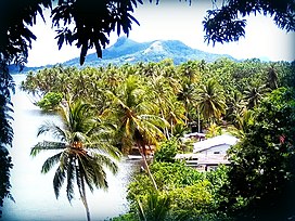
61:
304:
183:
372:
367:
234:
179:
468:
649:
249:
702:
622:
397:
152:
109:
392:
642:
54:
160:
695:
521:
614:
473:
448:
415:
362:
483:
382:
299:
121:
314:
294:
239:
590:
526:
443:
155:. Rising to a height of 1,100 feet (340 m), it is not the highest peak of Weno, which is
671:
208:
171:. The mountain also has extensive remains of mainly Japanese fortifications erected during
453:
336:
679:
626:
738:
722:
156:
516:
488:
387:
172:
168:
28:
148:
105:
420:
281:
US National
Register of Historic Places in the Federated States of Micronesia
76:
63:
478:
729:
National
Register of Historic Places in the Federated States of Micronesia
506:
425:
182:
on
September 30, 1976, a time when Chuuk was part of the US-administered
159:
to the south. Tonnachau is, however, a prominent landmark rising above
164:
44:
511:
229:
144:
101:
678:
This
National Register of Historic Places-related article is a
253:
683:
630:
16:
Mountain on Weno Island, Federated States of
Micronesia
539:
497:
434:
406:
353:
344:
310:
History of the
National Register of Historic Places
287:
120:
115:
97:
92:
53:
43:
38:
21:
464:Japanese Elementary School for Ponapean Children
734:Mountains of the Federated States of Micronesia
744:Federated States of Micronesia geography stubs
703:
650:
265:
178:The mountain was listed on the United States
8:
710:
696:
657:
643:
580:
459:Japanese Artillery Road and Pohndolap Area
350:
272:
258:
250:
18:
749:Oceania Registered Historic Places stubs
388:Truk Lagoon Underwater Fleet, Truk Atoll
209:"NRHP nomination for Tonnachau Mountain"
195:
230:"National Register Information System"
203:
201:
199:
184:Trust Territory of the Pacific Islands
7:
668:
666:
611:
609:
235:National Register of Historic Places
180:National Register of Historic Places
469:Japanese Hydro-electric Power Plant
14:
507:Bechiel Village Historic District
670:
613:
589:
579:
570:
569:
335:
328:
27:
623:Federated States of Micronesia
398:Xavier High School, Micronesia
153:Federated States of Micronesia
110:Federated States of Micronesia
1:
682:. You can help Knowledge by
629:. You can help Knowledge by
557:National Historic Landmarks
161:Chuuk International Airport
765:
665:
608:
393:Wiichen Men's Meetinghouse
368:Japanese Army Headquarters
167:and established rule over
49:1,100 ft (340 m)
565:
449:Chief Agriculturist House
363:Fauba Archaeological Site
326:
26:
135:(also variously spelled
522:Rull Men's Meetinghouse
211:. National Park Service
625:location article is a
484:Sokehs Mass Grave Site
383:Tonotan Guns and Caves
300:Keeper of the Register
315:National Park Service
295:Contributing property
240:National Park Service
33:View from Fono Island
143:), is a mountain on
77:7.4596°N 151.84972°E
373:Japanese Lighthouse
73: /
444:Catholic Belltower
378:Tonnachau Mountain
133:Tonnachau Mountain
39:Highest point
22:Tonnachau Mountain
691:
690:
638:
637:
603:
602:
535:
534:
305:Historic district
130:
129:
82:7.4596; 151.84972
756:
712:
705:
698:
674:
667:
659:
652:
645:
617:
610:
593:
583:
582:
573:
572:
517:O'Keefe's Island
351:
339:
332:
331:
274:
267:
260:
251:
244:
243:
226:
220:
219:
217:
216:
205:
88:
87:
85:
84:
83:
78:
74:
71:
70:
69:
66:
31:
19:
764:
763:
759:
758:
757:
755:
754:
753:
719:
718:
717:
716:
664:
663:
606:
604:
599:
561:
531:
493:
474:Japanese Shrine
454:German Cemetery
430:
402:
346:
340:
334:
333:
329:
324:
283:
278:
248:
247:
242:. July 9, 2010.
228:
227:
223:
214:
212:
207:
206:
197:
192:
81:
79:
75:
72:
67:
64:
62:
60:
59:
34:
17:
12:
11:
5:
762:
760:
752:
751:
746:
741:
736:
731:
721:
720:
715:
714:
707:
700:
692:
689:
688:
675:
662:
661:
654:
647:
639:
636:
635:
618:
601:
600:
598:
597:
587:
577:
566:
563:
562:
560:
559:
554:
549:
543:
541:
537:
536:
533:
532:
530:
529:
524:
519:
514:
509:
503:
501:
495:
494:
492:
491:
486:
481:
476:
471:
466:
461:
456:
451:
446:
440:
438:
432:
431:
429:
428:
423:
418:
412:
410:
404:
403:
401:
400:
395:
390:
385:
380:
375:
370:
365:
359:
357:
348:
342:
341:
327:
325:
323:
322:
320:Property types
317:
312:
307:
302:
297:
291:
289:
285:
284:
279:
277:
276:
269:
262:
254:
246:
245:
221:
194:
193:
191:
188:
128:
127:
124:
118:
117:
113:
112:
99:
95:
94:
90:
89:
57:
51:
50:
47:
41:
40:
36:
35:
32:
24:
23:
15:
13:
10:
9:
6:
4:
3:
2:
761:
750:
747:
745:
742:
740:
737:
735:
732:
730:
727:
726:
724:
713:
708:
706:
701:
699:
694:
693:
687:
685:
681:
676:
673:
669:
660:
655:
653:
648:
646:
641:
640:
634:
632:
628:
624:
619:
616:
612:
607:
596:
592:
588:
586:
578:
576:
568:
567:
564:
558:
555:
553:
550:
548:
545:
544:
542:
538:
528:
525:
523:
520:
518:
515:
513:
512:Dinay Village
510:
508:
505:
504:
502:
500:
496:
490:
487:
485:
482:
480:
477:
475:
472:
470:
467:
465:
462:
460:
457:
455:
452:
450:
447:
445:
442:
441:
439:
437:
433:
427:
424:
422:
419:
417:
414:
413:
411:
409:
405:
399:
396:
394:
391:
389:
386:
384:
381:
379:
376:
374:
371:
369:
366:
364:
361:
360:
358:
356:
352:
349:
343:
338:
321:
318:
316:
313:
311:
308:
306:
303:
301:
298:
296:
293:
292:
290:
286:
282:
275:
270:
268:
263:
261:
256:
255:
252:
241:
237:
236:
231:
225:
222:
210:
204:
202:
200:
196:
189:
187:
185:
181:
176:
174:
170:
166:
162:
158:
157:Mount Teroken
154:
150:
146:
142:
138:
134:
125:
123:
122:Mountain type
119:
114:
111:
107:
103:
100:
96:
91:
86:
58:
56:
52:
48:
46:
42:
37:
30:
25:
20:
684:expanding it
677:
631:expanding it
620:
605:
527:Spanish Fort
489:Spanish Wall
377:
233:
224:
213:. Retrieved
177:
173:World War II
140:
136:
132:
131:
595:NRHP portal
547:Lighthouses
540:Other lists
416:Leluh Ruins
149:Chuuk State
106:Chuuk State
80: /
68:151°50′59″E
55:Coordinates
723:Categories
421:Likinlulem
345:Properties
215:2015-03-30
190:References
169:the lagoon
147:Island in
479:Nan Madol
141:Tonaachaw
93:Geography
65:7°27′35″N
45:Elevation
575:Category
426:Safonfok
347:by state
137:Tonachau
126:Volcanic
98:Location
552:Museums
436:Pohnpei
151:of the
116:Geology
408:Kosrae
288:Topics
165:Kosrae
621:This
355:Chuuk
739:Weno
680:stub
627:stub
585:List
145:Weno
139:and
102:Moen
499:Yap
725::
238:.
232:.
198:^
186:.
175:.
108:,
104:,
711:e
704:t
697:v
686:.
658:e
651:t
644:v
633:.
273:e
266:t
259:v
218:.
Text is available under the Creative Commons Attribution-ShareAlike License. Additional terms may apply.