127:
134:
231:
29:
340:
919:
647:
884:
606:
242:, covering 84.92 km (32.79 sq mi). It contains 61% of the endemic angiosperm plants of Cape Verde, of which 25% are in the red list of endangered species, including
409:
304:
960:
249:. Free grazing is a threat to the biodiversity of the area. Tope de Coroa consists of relatively young volcanic rock, formed between 200,000 and 170,000 years ago.
599:
126:
924:
547:
402:
753:
505:
83:
592:
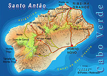
215:. At 1,979 m elevation, it is the highest point of the island. It is in the western part of the island, 25 km west of the island capital
615:
239:
652:
568:
395:
965:
955:
552:
258:
709:
479:
542:
76:
189:
781:
934:
903:
419:
379:
204:
161:
889:
773:
768:
714:
696:
300:
263:
816:
629:
532:
474:
223:
origin. The area is the source of several streams including
Ribeira de Monte Trigo which flows westward to
879:
829:
573:
216:
177:
54:
355:
Sampling the Cape Verde Mantle Plume: Evolution of Melt
Compositions on Santo Antão, Cape Verde Island
328:
796:
642:
464:
69:
839:
701:
469:
244:
230:
860:
855:
64:
657:
537:
834:
824:
791:
732:
448:
686:
681:
489:
358:
800:
786:
737:
484:
637:
929:
949:
870:
727:
691:
633:
433:
182:
316:
894:
438:
285:
719:
584:
224:
362:
758:
516:
208:
165:
28:
98:
85:
387:
874:
865:
673:
510:
220:
212:
44:
229:
588:
391:
234:
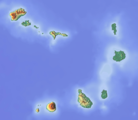
Map of the island of Santo Antão with Tope de Coroa on the left
319:, Estratégia e Plano Nacional de Negócios das Áreas Protegidas
912:
848:
809:
746:
666:
622:
561:
525:
498:
457:
426:
188:
176:
171:
157:
114:
75:
63:
53:
43:
38:
21:
33:View of the mountain summit (in the background)
600:
403:
8:
607:
593:
585:
410:
396:
388:
341:Consultoria em Gestão de Recursos Naturais
296:
294:
281:
279:
18:
920:Ilhéu de Curral Velho and Adjacent Coast
754:Cova-Paul-Ribeira da Torre Natural Park
506:Cova-Paul-Ribeira da Torre Natural Park
275:
301:Cabo Verde, Statistical Yearbook 2015
133:
7:
961:Geography of Santo Antão, Cape Verde
288:Peaklist.org. Retrieved 2012-04-22.
14:
305:Instituto Nacional de Estatística
357:. Vol. 47. p. 145-18.
132:
125:
27:
553:Farol de Fontes Pereira de Melo
259:List of mountains in Cape Verde
203:is a mountain on the island of
885:Monte Caçador and Pico Forcado
219:. The mountain is entirely of
1:
616:Protected Areas of Cape Verde
331:, Áreas protegidas Cabo Verde
380:Áreas protegidas, Cabo Verde
148:on the island of Santo Antão
59:1,979 m (6,493 ft)
49:1,979 m (6,493 ft)
526:Other geographical features
238:The mountain forms part of
982:
900:Monte Santo António (Maio)
353:Holm, Paul Martin (2006).
286:"Africa Ultra-Prominences"
543:Ponta do Chão de Mangrade
119:
26:
871:Pedra de Lume salt ponds
782:Serra do Pico de Antónia
623:Integral Nature Reserves
363:10.1093/petrology/egi071
343:, Isildo Gomes, p. 17-30
264:List of Ultras of Africa
194:around 200,000 years ago
966:Porto Novo Municipality
956:Mountains of Cape Verde
935:Porto Inglês salt flats
904:Porto Inglês salt flats
146:Location in Cape Verde,
880:Santa Maria salt ponds
574:Agostinho Neto Airport
235:
16:Mountain in Cape Verde
648:Ilhéu de Curral Velho
233:
99:17.03250°N 25.29583°W
925:Pedra Badejo Lagoons
849:Protected Landscapes
533:Canal de São Vicente
517:Moroços Natural Park
465:Ribeira de Alto Mira
317:Resolução nº 36/2016
830:Monte Santo António
245:Periploca laevigata
104:17.03250; -25.29583
95: /
817:Morrinho de Açúcar
653:Ilhéu dos Pássaros
236:
39:Highest point
943:
942:
821:Morrinho do Filho
810:Natural Monuments
792:Fogo Natural Park
778:Norte (Boa Vista)
643:Ilhéu de Baluarte
582:
581:
480:Ribeira da Janela
449:Gudo de Cavaleiro
247:subsp. chevalieri
198:
197:
973:
897:and Monte Branco
840:Ilhéu de Sal Rei
702:Baía da Murdeira
682:Costa da Fragata
678:Alto das Cabaças
609:
602:
595:
586:
490:Ribeira da Torre
470:Ribeira da Garça
412:
405:
398:
389:
384:
367:
366:
350:
344:
338:
332:
329:Parques Naturais
326:
320:
314:
308:
298:
289:
283:
136:
135:
129:
110:
109:
107:
106:
105:
100:
96:
93:
92:
91:
88:
31:
19:
981:
980:
976:
975:
974:
972:
971:
970:
946:
945:
944:
939:
908:
866:Buracona-Ragona
844:
805:
787:Serra Malagueta
742:
738:Terras Salgadas
667:Nature Reserves
662:
658:Ilhéus do Rombo
618:
613:
583:
578:
557:
538:Praia d'Aranhas
521:
499:Protected areas
494:
485:Ribeira do Paul
453:
422:
416:
383:(in Portuguese)
382:
376:
371:
370:
352:
351:
347:
339:
335:
327:
323:
315:
311:
299:
292:
284:
277:
272:
255:
153:
152:
151:
150:
149:
147:
144:
143:
142:
141:
137:
103:
101:
97:
94:
89:
86:
84:
82:
81:
34:
17:
12:
11:
5:
979:
977:
969:
968:
963:
958:
948:
947:
941:
940:
938:
937:
932:
930:Lagoa do Rabil
927:
922:
916:
914:
910:
909:
907:
906:
901:
898:
892:
887:
882:
877:
868:
863:
858:
852:
850:
846:
845:
843:
842:
837:
835:Rocha Estância
832:
827:
825:Monte Estância
822:
819:
813:
811:
807:
806:
804:
803:
794:
789:
784:
779:
776:
771:
766:
761:
756:
750:
748:
744:
743:
741:
740:
735:
733:Praia do Morro
730:
725:
722:
717:
712:
710:Morro de Areia
707:
704:
699:
694:
689:
684:
679:
676:
670:
668:
664:
663:
661:
660:
655:
650:
645:
640:
626:
624:
620:
619:
614:
612:
611:
604:
597:
589:
580:
579:
577:
576:
571:
565:
563:
559:
558:
556:
555:
550:
545:
540:
535:
529:
527:
523:
522:
520:
519:
514:
513:Nature Reserve
508:
502:
500:
496:
495:
493:
492:
487:
482:
477:
475:Ribeira Grande
472:
467:
461:
459:
455:
454:
452:
451:
446:
441:
436:
430:
428:
424:
423:
418:The island of
417:
415:
414:
407:
400:
392:
386:
385:
375:
374:External links
372:
369:
368:
345:
333:
321:
309:
290:
274:
273:
271:
268:
267:
266:
261:
254:
251:
240:a natural park
196:
195:
192:
186:
185:
180:
174:
173:
169:
168:
159:
155:
154:
145:
139:
138:
131:
130:
124:
123:
122:
121:
120:
117:
116:
112:
111:
79:
73:
72:
67:
61:
60:
57:
51:
50:
47:
41:
40:
36:
35:
32:
24:
23:
15:
13:
10:
9:
6:
4:
3:
2:
978:
967:
964:
962:
959:
957:
954:
953:
951:
936:
933:
931:
928:
926:
923:
921:
918:
917:
915:
911:
905:
902:
899:
896:
893:
891:
888:
886:
883:
881:
878:
876:
872:
869:
867:
864:
862:
859:
857:
854:
853:
851:
847:
841:
838:
836:
833:
831:
828:
826:
823:
820:
818:
815:
814:
812:
808:
802:
798:
795:
793:
790:
788:
785:
783:
780:
777:
775:
772:
770:
767:
765:
764:Tope de Coroa
762:
760:
757:
755:
752:
751:
749:
747:Natural Parks
745:
739:
736:
734:
731:
729:
728:Lagoa Cimidor
726:
723:
721:
718:
716:
713:
711:
708:
706:Boa Esperança
705:
703:
700:
698:
695:
693:
692:Rabo de Junco
690:
688:
687:Ponta do Sinó
685:
683:
680:
677:
675:
672:
671:
669:
665:
659:
656:
654:
651:
649:
646:
644:
641:
639:
635:
631:
628:
627:
625:
621:
617:
610:
605:
603:
598:
596:
591:
590:
587:
575:
572:
570:
567:
566:
564:
560:
554:
551:
549:
546:
544:
541:
539:
536:
534:
531:
530:
528:
524:
518:
515:
512:
509:
507:
504:
503:
501:
497:
491:
488:
486:
483:
481:
478:
476:
473:
471:
468:
466:
463:
462:
460:
456:
450:
447:
445:
444:Tope de Coroa
442:
440:
437:
435:
432:
431:
429:
425:
421:
413:
408:
406:
401:
399:
394:
393:
390:
381:
378:
377:
373:
364:
360:
356:
349:
346:
342:
337:
334:
330:
325:
322:
318:
313:
310:
306:
302:
297:
295:
291:
287:
282:
280:
276:
269:
265:
262:
260:
257:
256:
252:
250:
248:
246:
241:
232:
228:
226:
222:
218:
214:
210:
206:
205:Santo Antão's
202:
201:Tope de Coroa
193:
191:
190:Last eruption
187:
184:
183:Stratovolcano
181:
179:
178:Mountain type
175:
170:
167:
163:
160:
156:
140:Tope de Coroa
128:
118:
113:
108:
80:
78:
74:
71:
68:
66:
62:
58:
56:
52:
48:
46:
42:
37:
30:
25:
22:Tope de Coroa
20:
913:Ramsar sites
895:Monte Penoso
890:Curral Velho
861:Monte Grande
763:
724:Casas Velhas
715:Ponta do Sol
638:Ilhéu Branco
562:Other topics
548:Ponta do Sol
443:
439:Pico da Cruz
434:Cova Caldera
354:
348:
336:
324:
312:
243:
237:
200:
199:
774:Monte Gordo
769:Monte Verde
697:Serra Negra
630:Santa Luzia
420:Santo Antão
225:Monte Trigo
162:Santo Antão
102: /
77:Coordinates
950:Categories
634:Ilhéu Raso
270:References
217:Porto Novo
209:Cape Verde
166:Cape Verde
90:25°17′45″W
87:17°01′57″N
55:Prominence
720:Tartaruga
427:Mountains
115:Geography
45:Elevation
875:Cagarral
801:Figueira
797:Barreiro
674:Cruzinha
511:Cruzinha
253:See also
221:volcanic
158:Location
759:Moroços
458:Streams
307:, p. 25
172:Geology
65:Listing
856:Pombas
569:Sports
213:Africa
70:Ultra
873:and
636:and
359:doi
227:.
952::
632:,
303:,
293:^
278:^
211:,
207:,
164:,
799:-
608:e
601:t
594:v
411:e
404:t
397:v
365:.
361::
Text is available under the Creative Commons Attribution-ShareAlike License. Additional terms may apply.