536:
1551:
44:
544:
425:
73:
328:
106:
645:
591:. Another settler built a hotel on the opposite side of the lake with the hopes that the railroad would instead run along the east side of Mullett Lake. In 1881, the Michigan Central Railroad constructed its line on the west side through Pike's property, and this led to the growth of the Topinabee community. The train depot was built the following year.
113:
80:
785:
698:
in July 2000. By early 2022, the library received numerous structural upgrades, including new paint, interior shelving, and improvements to the surrounding environment. The
Topinabee Library is listed as part of the US-23 Heritage Route. The area around the library and Lake Mullett shoreline has
631:
Pike died in 1900, and Edward Bailey purchased the hotel and renamed it Pike's Summer Tavern. The hotel burned down in 1917 but was rebuilt the next year and named Hotel
Topinabee. By this time, Topinabee had an established population and downtown area that included several shops and a bowling
652:
In 1958, the railway line was disestablished, and the train depot was bought by the township. The former station was converted into a historical museum and library, while the railway lines themselves were eventually removed. The structure was then converted into a full-time library, which still
586:
and frequently traveled up north through the area. He was so impressed with the location that he wanted to settle in the area in anticipation of the expanding railroad. Pike built his tavern on the west side of
Mullett Lake prior to the railroad's construction. He purchased land, opened his
522:
The
Mullett Township Hall and Fire Department is located in Topinabee at 1491 North Straits Highway. The fire department serves the community, the portion of the Mullett Township on the west side of Mullett Lake, and portions of the neighboring townships. The community is served by
518:
services. The post office is located in the center of the community at 1593 North
Straits Highway. Most of the community itself is served by the Cheboygan 49791 ZIP Code, while areas to the south are served by the Indian River 49749 ZIP Code.
602:, a tavern, and a casino. By 1886, trains ran daily through Topinabee. Pike sold many plats of his property to allow settlers to build cottages, and Topinabee became a popular resort community. The community had a population of 34 in 1895.
598:. The community centered along the railroad, and Pike's hotel served as a main business for early travelers. The hotel was three stories tall and could accommodate up to 40 guest. The community grew to include a boat launch along the
628:. The steamship would stop in Topinabee for an hour along its route for passengers to have dinner. Several other steamboats also utilized the Inland Waterway, which, in addition to the railroad, brought many people to Topinabee.
948:
733:
923:
1946:
594:
A post office in
Topinabee opened on April 17, 1882 with Daniel Stofer serving as the first postmaster. A railroad depot was built near the shores of the lake about 8.0 miles (12.9 km) north of
636:, the hotel no longer became profitable and was sold to Edward Moloney for $ 850 in 1935. The hotel closed in 1950, and another fire in 1965 led to the hotel being razed in 1970.
1489:
632:
alley. The community became a popular tourist destination due to its scenic and peaceful environment. The hotel burned down again in 1928 and was rebuilt again. During the
416:
As an unincorporated community, Topinabee has no legally defined boundaries or population statistics of its own but does have its own post office with the 49791 ZIP Code.
1657:
1951:
679:, which was completed in 2007. The 75-mile-long (121 km) trail is used primarily for biking, as well as snowmobiles during the winter. The trail connects
1956:
1892:
1886:
1262:
1695:
488:
1868:
1843:
1823:
1818:
1803:
1753:
1665:
1627:
1614:
1604:
1632:
1773:
1609:
1961:
1482:
43:
141:
1062:
1475:
303:
105:
1407:
695:
1084:
575:. While Pike suggested the name Topinabee, the railroad company suggested the name Portage, but it was deemed too common of a name.
1287:
384:
72:
687:
and runs directly through
Topinabee along the shores of Lake Mullett. The Topinabee Trailhead is 5.4 miles (8.7 km) north of
1051:
Michigan Place Names: The
History of the Founding and the Naming of More Than Five Thousand Past and Present Michigan Communities
1467:
1160:
1017:
495:
is directly to the south. Numerous other lakefront unincorporated communities are located to the north along M-27, including
1328:
1291:
500:
1838:
1833:
1828:
1813:
1798:
1788:
1778:
1763:
1685:
1642:
1599:
1054:
193:
1783:
1652:
453:
535:
1863:
1853:
1848:
1808:
1793:
1758:
1670:
1647:
1499:
599:
587:
business, and platted the community with the hopes that the railroad would pass through the area on its way to the
480:
441:
437:
406:
398:
210:
198:
1386:
1768:
1700:
1690:
1637:
898:
676:
665:
661:
552:
468:
1748:
1743:
1680:
1675:
1622:
1594:
291:
718:
886:
875:
864:
853:
1916:
1710:
1570:
1562:
684:
657:
504:
476:
464:
429:
49:
1364:
1718:
688:
595:
524:
508:
496:
492:
280:
1411:
559:. That year, hotel proprietor H. H. Pike moved to the area and platted the community. He named it for
543:
699:
been organized as the
Topinabee Beach Park with modern amenities along the North Central State Trail.
1923:
625:
568:
252:
1433:
424:
1733:
1576:
1540:
1521:
669:
621:
588:
579:
484:
394:
327:
274:
34:
1878:
833:
672:. The highway passes directly through Topinabee and is known locally as North Straits Highway.
479:
is to the south and connects the two large lakes, and this stretch of waterways is known as the
1334:
1297:
1058:
680:
644:
449:
242:
902:
633:
343:
1723:
583:
571:
in 1795. The treaty gave large areas of native lands to the
European settlers, including
515:
457:
1586:
617:
514:
Topinabee has its own post office with the 49791 ZIP Code, which is primarily used for
205:
1940:
572:
564:
296:
624:
with many stops along the way. The steamboat would sometimes head further north to
556:
445:
410:
996:
887:
U.S. Geological Survey Geographic Names Information System: Mullett Lake, Michigan
876:
U.S. Geological Survey Geographic Names Information System: Silver Beach, Michigan
694:
The Topinabee Library received a technology upgrade though a $ 7,804 grant by the
1134:
1113:
1514:
974:
854:
U.S. Geological Survey Geographic Names Information System: Long Point, Michigan
738:
865:
U.S. Geological Survey Geographic Names Information System: Birchwood, Michigan
719:
U.S. Geological Survey Geographic Names Information System: Topinabee, Michigan
764:
560:
181:
156:
143:
1237:
653:
houses a safe that contains many historic railroad records and photographs.
606:
472:
471:
runs about 1.0 mile (1.6 km) to the west. Located along Mullett Lake,
233:
1462:
1342:
1187:
811:
1907:‡This populated place also has portions in an adjacent county or counties
1550:
1338:
1305:
1301:
402:
267:
186:
1212:
660:, which is a state highway that serves as a direct connector route from
555:
officials planned to establish a resort here on the southern shores of
1333:(Map). . Lansing: Michigan State Highway Department. §§ E11–G10.
1296:(Map). . Lansing: Michigan State Highway Department. §§ E11–G10.
643:
542:
534:
423:
326:
259:
238:
1532:
691:
and continues north for 12.0 miles (19.3 km) to Cheboygan.
1471:
1263:"Topinabee Library Receiving Upgrades over Next Several Months"
675:
The path along the former railway line was converted into the
376:
1549:
1457:
318:
656:
By late-1961, Topinabee would benefit from the creation of
349:
367:
358:
1947:
Unincorporated communities in Cheboygan County, Michigan
612:
was established in 1903 along the Inland Waterway. The
1186:
Inland Water Route Historical Society (June 18, 2014).
1112:
Inland Water Route Historical Society (June 18, 2014).
1365:"North Central State Trail – Gaylord to Mackinaw City"
487:
is about 12 miles (19 km) to the northeast. The
1387:"Trail of the Week: NCST – Indian River to Topinabee"
385:
361:
467:, which is known locally as North Straits Highway.
373:
352:
346:
1902:
1877:
1732:
1709:
1585:
1561:
1531:
370:
364:
355:
313:
302:
290:
266:
249:
232:
224:
216:
204:
192:
180:
172:
25:
20:
Unincorporated community in Michigan, United States
832:Indian River Regional Chamber of Commerce (2022).
810:Michigan Economic Development Corporation (2022).
1554:Map of Michigan highlighting Cheboygan County.svg
551:The community was founded as early as 1881 when
786:"Community of Topinabee to the Mackinac Bridge"
648:Topinabee Library and North Central State Trail
567:(Great Bear Heart), who ultimately signed the
1483:
475:is 2.0 miles (3.2 km) to the west. The
8:
1412:"Committed grants: Topinabee Public Library"
527:centered just to the south in Indian River.
1432:Northeast Michigan Council of Governments.
1317:(Includes all changes through July 1, 1961)
1490:
1476:
1468:
1327:Michigan State Highway Department (1962).
463:The lakefront community is centered along
456:around 27 miles (43 km) south of the
22:
1135:"Mackinac Information: Topinabee History"
1044:
1042:
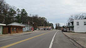
48:Looking north along N. Straits Highway (
1256:
1254:
1231:
1229:
1206:
1204:
1107:
1105:
1078:
1076:
1074:
708:
312:
301:
265:
231:
223:
215:
171:
136:
64:
56:
40:
1952:Unincorporated communities in Michigan
1085:"Topinabee: A Little Jewel on Mullett"
1083:Friday, Matthew J. (August 28, 2018).
758:
756:
728:
726:
714:
712:
1053:. Great Lakes Books Series. Detroit:
834:"Northern Michigan's Inland Waterway"
289:
248:
203:
191:
179:
92:Location within the state of Michigan
7:
1957:Populated places established in 1881
1352:– via Michigan History Center.
1315:– via Michigan History Center.
60:"A small community with a big heart"
1408:Bill & Melinda Gates Foundation
1238:"Mullett Township: Parks & Rec"
1018:"Cheboygan County School Districts"
696:Bill & Melinda Gates Foundation
405:. The community is located within
1498:Municipalities and communities of
1261:Hahn, Kortny (November 16, 2021).
997:"Mullett Township Fire Department"
616:ran daily and took travelers from
428:Signage along N. Straits Highway (
14:
1288:Michigan State Highway Department
763:UnitedStatesZipCodes.org (2022).
409:along the southwestern shores of
125:Location within the United States
112:
79:
1385:Top of Michigan Trails Council.
1363:Top of Michigan Trails Council.
539:Train station in the early 1900s
342:
111:
104:
78:
71:
42:
1962:1881 establishments in Michigan
620:through the Inland Waterway to
578:Pike, who was originally from
444:along the southwest shores of
1:
1025:Michigan Geographic Framework
331:U.S. Post Office in Topinabee
128:Show map of the United States
1887:Burt Lake Indian Reservation
1211:Topinabee, Michigan (2022).
1055:Wayne State University Press
668:to the north in the city of
1893:Mackinac Indian Reservation
1458:Topinabee community website
765:"ZIP Code 49791: Topinabee"
1978:
1501:Cheboygan County, Michigan
547:Former post office in 1917
1912:
1547:
1512:
1236:Mullett Township (2021).
995:Mullett Township (2022).
973:Mullett Township (2022).
903:"Topinabee – Post Office"
899:United States Post Office
812:"Pure Michigan:Topinabee"
677:North Central State Trail
553:Michigan Central Railroad
137:
65:
57:
41:
32:
1161:"Station: Topinabee, MI"
436:Topinabee is located in
395:unincorporated community
228:722 ft (220 m)
35:Unincorporated community
1267:Cheboygan Daily Tribune
1089:Cheboygan Daily Tribune
975:"Mullett Township Hall"
489:census-designated place
1555:
1049:Romig, Walter (1986).
649:
548:
540:
433:
332:
1553:
1165:Michiganrailroads.com
647:
546:
538:
427:
401:in the U.S. state of
330:
251: • Summer (
157:45.48389°N 84.59528°W
1925:United States portal
1330:Official Highway Map
1293:Official Highway Map
1213:"Topinabee: History"
949:"49749 ZIP Code map"
924:"49721 ZIP Code map"
734:"49791 ZIP Code map"
569:Treaty of Greenville
525:Inland Lakes Schools
95:Show map of Michigan
1879:Indian reservations
1434:"Topinabee Library"
1027:. November 15, 2013
589:Straits of Mackinac
580:Burlington, Vermont
162:45.48389; -84.59528
153: /
27:Topinabee, Michigan
1819:Mullett Lake Woods
1779:Fingerboard Corner
1556:
650:
549:
541:
434:
333:
1934:
1933:
1463:Topinabee Library
1064:978-0-8143-1838-6
450:Northern Michigan
325:
324:
319:Community website
1969:
1926:
1919:
1552:
1524:
1517:
1507:
1502:
1492:
1485:
1478:
1469:
1445:
1444:
1442:
1440:
1429:
1423:
1422:
1420:
1418:
1404:
1398:
1397:
1395:
1393:
1382:
1376:
1375:
1373:
1371:
1360:
1354:
1353:
1351:
1349:
1324:
1318:
1316:
1314:
1312:
1284:
1278:
1277:
1275:
1273:
1258:
1249:
1248:
1246:
1244:
1233:
1224:
1223:
1221:
1219:
1208:
1199:
1198:
1196:
1194:
1183:
1177:
1176:
1174:
1172:
1157:
1151:
1150:
1148:
1146:
1139:MackinawInfo.com
1131:
1125:
1124:
1122:
1120:
1109:
1100:
1099:
1097:
1095:
1080:
1069:
1068:
1046:
1037:
1036:
1034:
1032:
1022:
1014:
1008:
1007:
1005:
1003:
992:
986:
985:
983:
981:
970:
964:
963:
961:
959:
945:
939:
938:
936:
934:
920:
914:
913:
911:
909:
895:
889:
884:
878:
873:
867:
862:
856:
851:
845:
844:
842:
840:
829:
823:
822:
820:
818:
807:
801:
800:
798:
796:
782:
776:
775:
773:
771:
760:
751:
750:
748:
746:
730:
721:
716:
664:in the south to
634:Great Depression
448:. It is in the
442:Cheboygan County
438:Mullett Township
399:Cheboygan County
389:
383:
382:
379:
378:
375:
372:
369:
366:
363:
360:
357:
354:
351:
348:
321:
256:
168:
167:
165:
164:
163:
158:
154:
151:
150:
149:
146:
129:
115:
114:
108:
96:
82:
81:
75:
46:
23:
1977:
1976:
1972:
1971:
1970:
1968:
1967:
1966:
1937:
1936:
1935:
1930:
1924:
1918:Michigan portal
1917:
1908:
1898:
1873:
1735:
1728:
1705:
1587:Civil townships
1581:
1557:
1545:
1527:
1522:
1515:
1508:
1505:
1500:
1496:
1454:
1449:
1448:
1438:
1436:
1431:
1430:
1426:
1416:
1414:
1406:
1405:
1401:
1391:
1389:
1384:
1383:
1379:
1369:
1367:
1362:
1361:
1357:
1347:
1345:
1326:
1325:
1321:
1310:
1308:
1286:
1285:
1281:
1271:
1269:
1260:
1259:
1252:
1242:
1240:
1235:
1234:
1227:
1217:
1215:
1210:
1209:
1202:
1192:
1190:
1185:
1184:
1180:
1170:
1168:
1159:
1158:
1154:
1144:
1142:
1133:
1132:
1128:
1118:
1116:
1111:
1110:
1103:
1093:
1091:
1082:
1081:
1072:
1065:
1057:. p. 558.
1048:
1047:
1040:
1030:
1028:
1020:
1016:
1015:
1011:
1001:
999:
994:
993:
989:
979:
977:
972:
971:
967:
957:
955:
947:
946:
942:
932:
930:
922:
921:
917:
907:
905:
897:
896:
892:
885:
881:
874:
870:
863:
859:
852:
848:
838:
836:
831:
830:
826:
816:
814:
809:
808:
804:
794:
792:
784:
783:
779:
769:
767:
762:
761:
754:
744:
742:
732:
731:
724:
717:
710:
705:
642:
600:Inland Waterway
584:Niles, Michigan
533:
516:post office box
481:Inland Waterway
458:Mackinac Bridge
454:Lower Peninsula
422:
407:Mullet Township
387:
345:
341:
335:
334:
317:
286:
284:
278:
250:
161:
159:
155:
152:
147:
144:
142:
140:
139:
133:
132:
131:
130:
127:
126:
123:
122:
121:
120:
116:
99:
98:
97:
94:
93:
90:
89:
88:
87:
83:
61:
53:
37:
28:
21:
12:
11:
5:
1975:
1973:
1965:
1964:
1959:
1954:
1949:
1939:
1938:
1932:
1931:
1929:
1928:
1921:
1913:
1910:
1909:
1906:
1904:
1900:
1899:
1897:
1896:
1890:
1883:
1881:
1875:
1874:
1872:
1871:
1866:
1861:
1856:
1851:
1846:
1841:
1836:
1831:
1826:
1821:
1816:
1811:
1806:
1801:
1796:
1791:
1786:
1781:
1776:
1771:
1766:
1761:
1756:
1751:
1746:
1740:
1738:
1730:
1729:
1727:
1726:
1721:
1715:
1713:
1707:
1706:
1704:
1703:
1698:
1693:
1688:
1683:
1678:
1673:
1668:
1663:
1655:
1650:
1645:
1640:
1635:
1630:
1625:
1620:
1612:
1607:
1602:
1597:
1591:
1589:
1583:
1582:
1580:
1579:
1574:
1567:
1565:
1559:
1558:
1548:
1546:
1544:
1543:
1537:
1535:
1529:
1528:
1513:
1510:
1509:
1497:
1495:
1494:
1487:
1480:
1472:
1466:
1465:
1460:
1453:
1452:External links
1450:
1447:
1446:
1424:
1399:
1377:
1355:
1319:
1279:
1250:
1225:
1200:
1188:"Introduction"
1178:
1152:
1126:
1101:
1070:
1063:
1038:
1009:
987:
965:
940:
915:
890:
879:
868:
857:
846:
824:
802:
777:
752:
722:
707:
706:
704:
701:
641:
640:Recent history
638:
563:tribal leader
532:
529:
483:. The city of
452:region of the
421:
418:
323:
322:
315:
311:
310:
307:
300:
299:
294:
288:
287:
272:
270:
264:
263:
257:
247:
246:
236:
230:
229:
226:
222:
221:
218:
214:
213:
208:
202:
201:
196:
190:
189:
184:
178:
177:
174:
170:
169:
135:
134:
124:
118:
117:
110:
109:
103:
102:
101:
100:
91:
85:
84:
77:
76:
70:
69:
68:
67:
66:
63:
62:
59:
55:
54:
47:
39:
38:
33:
30:
29:
26:
19:
18:
17:
13:
10:
9:
6:
4:
3:
2:
1974:
1963:
1960:
1958:
1955:
1953:
1950:
1948:
1945:
1944:
1942:
1927:
1922:
1920:
1915:
1914:
1911:
1905:
1901:
1894:
1891:
1888:
1885:
1884:
1882:
1880:
1876:
1870:
1867:
1865:
1862:
1860:
1857:
1855:
1852:
1850:
1847:
1845:
1842:
1840:
1837:
1835:
1834:Pries Landing
1832:
1830:
1829:Point Landing
1827:
1825:
1824:Orchard Beach
1822:
1820:
1817:
1815:
1812:
1810:
1807:
1805:
1802:
1800:
1797:
1795:
1794:Giauque Beach
1792:
1790:
1787:
1785:
1782:
1780:
1777:
1775:
1772:
1770:
1767:
1765:
1762:
1760:
1757:
1755:
1752:
1750:
1747:
1745:
1742:
1741:
1739:
1737:
1731:
1725:
1722:
1720:
1717:
1716:
1714:
1712:
1708:
1702:
1699:
1697:
1694:
1692:
1689:
1687:
1684:
1682:
1679:
1677:
1674:
1672:
1669:
1667:
1664:
1662:
1659:
1656:
1654:
1651:
1649:
1646:
1644:
1641:
1639:
1636:
1634:
1631:
1629:
1626:
1624:
1621:
1619:
1616:
1613:
1611:
1608:
1606:
1603:
1601:
1598:
1596:
1593:
1592:
1590:
1588:
1584:
1578:
1575:
1572:
1571:Mackinaw City
1569:
1568:
1566:
1564:
1560:
1542:
1539:
1538:
1536:
1534:
1530:
1526:
1525:
1518:
1511:
1506:United States
1503:
1493:
1488:
1486:
1481:
1479:
1474:
1473:
1470:
1464:
1461:
1459:
1456:
1455:
1451:
1435:
1428:
1425:
1413:
1410:(July 2000).
1409:
1403:
1400:
1388:
1381:
1378:
1366:
1359:
1356:
1344:
1340:
1336:
1332:
1331:
1323:
1320:
1307:
1303:
1299:
1295:
1294:
1289:
1283:
1280:
1268:
1264:
1257:
1255:
1251:
1239:
1232:
1230:
1226:
1214:
1207:
1205:
1201:
1189:
1182:
1179:
1166:
1162:
1156:
1153:
1140:
1136:
1130:
1127:
1115:
1108:
1106:
1102:
1090:
1086:
1079:
1077:
1075:
1071:
1066:
1060:
1056:
1052:
1045:
1043:
1039:
1026:
1019:
1013:
1010:
998:
991:
988:
976:
969:
966:
954:
950:
944:
941:
929:
925:
919:
916:
904:
900:
894:
891:
888:
883:
880:
877:
872:
869:
866:
861:
858:
855:
850:
847:
835:
828:
825:
813:
806:
803:
791:
787:
781:
778:
766:
759:
757:
753:
741:
740:
735:
729:
727:
723:
720:
715:
713:
709:
702:
700:
697:
692:
690:
686:
685:Mackinaw City
682:
678:
673:
671:
667:
666:U.S. Route 23
663:
662:Interstate 75
659:
654:
646:
639:
637:
635:
629:
627:
623:
619:
615:
611:
608:
603:
601:
597:
592:
590:
585:
581:
576:
574:
573:Fort Dearborn
570:
566:
562:
558:
554:
545:
537:
530:
528:
526:
520:
517:
512:
510:
506:
502:
498:
494:
490:
486:
482:
478:
474:
470:
469:Interstate 75
466:
461:
459:
455:
451:
447:
443:
439:
431:
426:
419:
417:
414:
412:
408:
404:
400:
396:
392:
391:
381:
339:
329:
320:
316:
308:
305:
298:
295:
293:
282:
276:
271:
269:
261:
258:
254:
244:
243:Eastern (EST)
240:
237:
235:
227:
219:
212:
209:
207:
200:
197:
195:
188:
185:
183:
176:United States
175:
166:
138:Coordinates:
107:
74:
51:
45:
36:
31:
24:
16:
1858:
1854:Silver Beach
1814:Mullett Lake
1719:Indian River
1660:
1617:
1520:
1437:. Retrieved
1427:
1415:. Retrieved
1402:
1390:. Retrieved
1380:
1368:. Retrieved
1358:
1346:. Retrieved
1329:
1322:
1309:. Retrieved
1292:
1282:
1272:December 31,
1270:. Retrieved
1266:
1241:. Retrieved
1216:. Retrieved
1191:. Retrieved
1181:
1169:. Retrieved
1164:
1155:
1143:. Retrieved
1138:
1129:
1117:. Retrieved
1094:December 31,
1092:. Retrieved
1088:
1050:
1031:December 28,
1029:. Retrieved
1024:
1012:
1002:November 10,
1000:. Retrieved
990:
980:November 10,
978:. Retrieved
968:
956:. Retrieved
952:
943:
931:. Retrieved
927:
918:
906:. Retrieved
893:
882:
871:
860:
849:
839:November 12,
837:. Retrieved
827:
817:November 13,
815:. Retrieved
805:
795:November 11,
793:. Retrieved
789:
780:
768:. Retrieved
743:. Retrieved
737:
693:
689:Indian River
674:
655:
651:
630:
613:
609:
604:
596:Indian River
593:
577:
557:Mullett Lake
550:
521:
513:
509:Mullett Lake
505:Silver Beach
493:Indian River
477:Indian River
462:
446:Mullett Lake
435:
415:
411:Mullett Lake
337:
336:
281:Indian River
58:Motto:
15:
1864:Veery Point
1789:Geyersville
1736:communities
1658:Maple Grove
1516:County seat
1348:October 17,
1311:October 17,
1114:"Topinabee"
958:November 9,
953:Google Maps
933:November 9,
928:Google Maps
908:November 9,
790:Google Maps
770:November 9,
745:November 9,
739:Google Maps
582:, moved to
268:ZIP code(s)
160: /
1941:Categories
1839:Riggsville
1809:Long Point
1799:Grand View
1439:January 1,
1417:January 1,
1392:January 1,
1370:January 1,
1243:January 1,
1218:January 1,
1193:January 1,
1171:January 1,
1145:January 1,
1119:January 1,
703:References
626:St. Ignace
561:Potawatomi
497:Long Point
306:feature ID
148:84°35′43″W
145:45°29′02″N
1903:Footnotes
1859:Topinabee
1849:Royal Oak
1764:Burt Lake
1759:Birchwood
1686:Tuscarora
1661:(defunct)
1643:Inverness
1618:(defunct)
1600:Beaugrand
1577:Wolverine
1541:Cheboygan
1523:Cheboygan
1343:173191490
670:Cheboygan
622:Cheboygan
614:Topinabee
610:Topinabee
607:steamboat
565:Topinabee
501:Birchwood
485:Cheboygan
473:Burt Lake
420:Geography
338:Topinabee
292:Area code
275:Cheboygan
234:Time zone
225:Elevation
199:Cheboygan
119:Topinabee
86:Topinabee
1869:Wildwood
1804:Haakwood
1774:Elmhurst
1653:Mackinaw
1563:Villages
1339:12701120
1306:51857665
1302:12701120
1290:(1961).
901:(2022).
403:Michigan
393:) is an
206:Township
187:Michigan
1784:Freedom
1754:Alverno
1696:Waverly
1671:Mullett
1648:Koehler
951:(Map).
926:(Map).
788:(Map).
736:(Map).
681:Gaylord
531:History
390:-uh-bee
314:Website
309:1614963
279:49749 (
273:49721 (
217:Settled
211:Mullett
173:Country
1701:Wilmot
1691:Walker
1666:Mentor
1638:Hebron
1628:Forest
1615:Duncan
1605:Benton
1337:
1300:
1167:. 2023
1141:. 2016
1061:
507:, and
194:County
1844:Rondo
1749:Aloha
1744:Afton
1734:Other
1724:Tower
1681:Nunda
1676:Munro
1633:Grant
1623:Ellis
1595:Aloha
1021:(PDF)
285:49791
262:(EDT)
260:UTC-4
239:UTC-5
182:State
1711:CDPs
1610:Burt
1533:City
1441:2023
1419:2022
1394:2023
1372:2023
1350:2019
1335:OCLC
1313:2019
1298:OCLC
1274:2022
1245:2023
1220:2023
1195:2023
1173:2023
1147:2023
1121:2023
1096:2022
1059:ISBN
1033:2022
1004:2022
982:2022
960:2022
935:2022
910:2022
841:2022
819:2022
797:2022
772:2022
747:2022
658:M-27
618:Oden
605:The
465:M-27
430:M-27
386:top-
304:GNIS
220:1881
50:M-27
1769:Dow
683:to
491:of
440:in
397:in
297:231
253:DST
1943::
1519::
1504:,
1341:,
1304:,
1265:.
1253:^
1228:^
1203:^
1163:.
1137:.
1104:^
1087:.
1073:^
1041:^
1023:.
755:^
725:^
711:^
511:.
503:,
499:,
460:.
413:.
388:EN
377:iː
1895:‡
1889:‡
1573:‡
1491:e
1484:t
1477:v
1443:.
1421:.
1396:.
1374:.
1276:.
1247:.
1222:.
1197:.
1175:.
1149:.
1123:.
1098:.
1067:.
1035:.
1006:.
984:.
962:.
937:.
912:.
843:.
821:.
799:.
774:.
749:.
432:)
380:/
374:b
371:ˈ
368:ʌ
365:ˈ
362:n
359:ɪ
356:ˈ
353:p
350:ɒ
347:t
344:/
340:(
283:)
277:)
255:)
245:)
241:(
52:)
Text is available under the Creative Commons Attribution-ShareAlike License. Additional terms may apply.