30:
787:
211:, built in 1954. More commonly known as "Little Bow" the lake is diverse and Watersports and Fishing are the common activities, on the lake with many starting out from the Little Bow Provincial Campground on the west end of the lake. On the east end of the lake, the Southern Alberta Bible Camp thrives with Camps happening all summer long and other activities year round. The Little Bow Resort, home to over 150 lake homes, Sits prominently on the west end of the lake. Most property around the lake is privately owned and many Cottages and acreages exist.
777:
117:
810:
418:
37:
256:
188:
29:
851:
283:
252:
880:
76:
844:
276:
837:
269:
367:
215:
214:
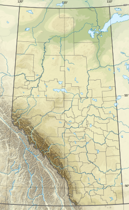
During the flooding in southern
Alberta in June 2013, operating structures associated with this reservoir were opened by
762:
663:
337:
757:
870:
726:
643:
447:
304:
417:
525:
487:
407:
372:
585:
545:
387:
875:
550:
540:
530:
638:
590:
575:
555:
535:
515:
352:
322:
721:
495:
520:
658:
570:
357:
235:
701:
691:
628:
560:
817:
736:
706:
633:
362:
204:
653:
505:
467:
437:
342:
312:
821:
752:
731:
711:
673:
500:
477:
452:
392:
108:
864:
781:
716:
648:
565:
472:
332:
58:
809:
791:
623:
618:
600:
595:
510:
377:
317:
580:
696:
668:
462:
457:
402:
397:
382:
347:
292:
91:
78:
610:
442:
429:
327:
200:
261:
683:
296:
208:
62:
122:
218:. Downstream waterflow increased from a normal 3 m/s to 60 m/s.
265:
416:
825:
745:
682:
609:
486:
428:
303:
184:
180:
172:
164:
156:
148:
140:
132:
128:
107:
68:
54:
18:
69:
845:
277:
8:
852:
838:
284:
270:
262:
15:
36:
227:
7:
806:
804:
152:22.5 km (8.7 sq mi)
14:
881:Southern Alberta geography stubs
808:
785:
775:
115:
35:
28:
171:
163:
155:
147:
139:
131:
1:
216:Alberta Environment and Water
53:
824:. You can help Knowledge by
763:Whooping Crane Summer Range
421:Rivers and lakes in Alberta
897:
803:
176:856 m (2,808 ft)
136:10.1 km (6.3 mi)
772:
644:Little Bow Lake Reservoir
414:
168:66.4 m (218 ft)
23:
160:18.3 m (60 ft)
236:"Alert CA-AB-AEA1-1728"
144:17 km (11 mi)
820:location article is a
422:
257:Atlas of Alberta Lakes
92:50.21944°N 112.83944°W
758:Peace–Athabasca Delta
420:
97:50.21944; -112.83944
88: /
571:North Wabasca Lake
423:
408:South Saskatchewan
373:North Saskatchewan
833:
832:
798:
797:
782:Rivers portal
753:Hay-Zama Wetlands
702:Columbia Icefield
197:Travers Reservoir
194:
193:
189:Travers Reservoir
173:Surface elevation
43:Travers Reservoir
19:Travers Reservoir
888:
871:Lakes of Alberta
854:
847:
840:
818:Southern Alberta
812:
805:
792:Lakes portal
790:
789:
788:
780:
779:
778:
737:Waputik Icefield
664:Milk River Ridge
286:
279:
272:
263:
240:
239:
232:
205:Little Bow River
121:
119:
118:
103:
102:
100:
99:
98:
93:
89:
86:
85:
84:
81:
71:
39:
38:
32:
16:
896:
895:
891:
890:
889:
887:
886:
885:
861:
860:
859:
858:
801:
799:
794:
786:
784:
776:
774:
768:
741:
678:
605:
482:
424:
412:
299:
290:
249:
244:
243:
234:
233:
229:
224:
116:
114:
111: countries
96:
94:
90:
87:
82:
79:
77:
75:
74:
50:
49:
48:
47:
46:
45:
44:
40:
12:
11:
5:
894:
892:
884:
883:
878:
873:
863:
862:
857:
856:
849:
842:
834:
831:
830:
813:
796:
795:
773:
770:
769:
767:
766:
760:
755:
749:
747:
743:
742:
740:
739:
734:
729:
724:
719:
714:
709:
704:
699:
694:
688:
686:
680:
679:
677:
676:
671:
666:
661:
656:
651:
646:
641:
636:
631:
626:
621:
615:
613:
607:
606:
604:
603:
598:
593:
588:
583:
578:
573:
568:
563:
558:
553:
548:
543:
538:
533:
528:
523:
518:
513:
508:
503:
498:
492:
490:
484:
483:
481:
480:
475:
470:
465:
460:
455:
450:
445:
440:
434:
432:
426:
425:
415:
413:
411:
410:
405:
400:
395:
390:
385:
380:
375:
370:
365:
360:
355:
350:
345:
340:
335:
330:
325:
320:
315:
309:
307:
301:
300:
291:
289:
288:
281:
274:
266:
260:
259:
254:
248:
247:External links
245:
242:
241:
226:
225:
223:
220:
192:
191:
186:
182:
181:
178:
177:
174:
170:
169:
166:
162:
161:
158:
154:
153:
150:
146:
145:
142:
138:
137:
134:
130:
129:
126:
125:
112:
105:
104:
72:
66:
65:
56:
52:
51:
42:
41:
34:
33:
27:
26:
25:
24:
21:
20:
13:
10:
9:
6:
4:
3:
2:
893:
882:
879:
877:
876:Vulcan County
874:
872:
869:
868:
866:
855:
850:
848:
843:
841:
836:
835:
829:
827:
823:
819:
814:
811:
807:
802:
793:
783:
771:
764:
761:
759:
756:
754:
751:
750:
748:
744:
738:
735:
733:
730:
728:
725:
723:
720:
718:
715:
713:
710:
708:
705:
703:
700:
698:
695:
693:
690:
689:
687:
685:
681:
675:
672:
670:
667:
665:
662:
660:
657:
655:
652:
650:
647:
645:
642:
640:
637:
635:
632:
630:
627:
625:
622:
620:
617:
616:
614:
612:
608:
602:
599:
597:
594:
592:
589:
587:
584:
582:
579:
577:
574:
572:
569:
567:
564:
562:
559:
557:
554:
552:
549:
547:
544:
542:
539:
537:
534:
532:
529:
527:
524:
522:
519:
517:
514:
512:
509:
507:
504:
502:
499:
497:
494:
493:
491:
489:
485:
479:
476:
474:
471:
469:
466:
464:
461:
459:
456:
454:
451:
449:
446:
444:
441:
439:
436:
435:
433:
431:
427:
419:
409:
406:
404:
401:
399:
396:
394:
391:
389:
386:
384:
381:
379:
376:
374:
371:
369:
366:
364:
361:
359:
356:
354:
351:
349:
346:
344:
341:
339:
336:
334:
331:
329:
326:
324:
321:
319:
316:
314:
311:
310:
308:
306:
302:
298:
294:
287:
282:
280:
275:
273:
268:
267:
264:
258:
255:
253:
251:
250:
246:
237:
231:
228:
221:
219:
217:
212:
210:
206:
202:
198:
190:
187:
183:
179:
175:
167:
159:
157:Average depth
151:
143:
135:
127:
124:
113:
110:
106:
101:
73:
67:
64:
60:
59:Vulcan County
57:
31:
22:
17:
826:expanding it
815:
800:
722:Saskatchewan
561:Lesser Slave
230:
213:
196:
195:
149:Surface area
634:Chestermere
448:Bridal Veil
293:Hydrography
133:Max. length
95: /
83:112°50′22″W
70:Coordinates
865:Categories
765:(wetlands)
654:Minnewanka
639:Kananaskis
611:Reservoirs
506:Beaverhill
430:Waterfalls
363:Little Bow
338:Clearwater
222:References
185:References
165:Max. depth
141:Max. width
80:50°13′10″N
692:Athabasca
674:Gleniffer
586:Ste. Anne
526:Crowsnest
501:Athabasca
468:Lundbreck
438:Athabasca
343:Crowsnest
313:Athabasca
201:reservoir
707:Crowfoot
684:Glaciers
659:Glenmore
649:McGregor
566:Miquelon
551:La Biche
546:Jackfish
531:Des Arcs
478:Sunwapta
453:Crescent
393:Red Deer
55:Location
727:Vulture
629:Brazeau
624:Barrier
619:Abraham
601:Wabamun
596:Utikuma
556:St. Cyr
541:Hubbles
511:Bistcho
473:Panther
388:Pembina
333:Brazeau
297:Alberta
209:Alberta
203:on the
63:Alberta
712:Hector
669:Sikome
591:Sylvan
576:Pigeon
536:Garner
516:Claire
378:Oldman
323:Beaver
318:Battle
305:Rivers
123:Canada
120:
816:This
746:Other
732:Wapta
717:Peyto
581:Santé
496:Amisk
488:Lakes
463:Elbow
458:Crypt
403:Smoky
398:Slave
383:Peace
353:Ghost
348:Elbow
199:is a
109:Basin
822:stub
521:Cold
368:Milk
697:Bow
443:Bow
358:Hay
328:Bow
295:of
207:in
867::
61:,
853:e
846:t
839:v
828:.
285:e
278:t
271:v
238:.
Text is available under the Creative Commons Attribution-ShareAlike License. Additional terms may apply.