301:
peak was scaled for the first time on 9 October 1966 by another Indian team led by
Chanchal Kumar Mitra & organised for the 2nd. time by Himalayan Association of calcutta. They ascended the east face of the south-east ridge and then took the south-east ridge to the top, mounting the summit bid from Camp 5, at about 21,860 ft (6,660 m). Nirapada Mallik (Dy.leader), Shyamal Chakrabarty, Nima Tashi ( former Dy.Director of training at The HMI Darjeeling) and Dorji sherpa were the summitters. Other members of the team were Manik Banerjee, K.K.Khanna, Marcopolo Srimal, Dr. Jungpangi from Geological Survey of India, Dr.Amitava Sen(M.O), Pinaki Sinha and Sailesh Chakraborty. The expedition was organised by the Himalayan Association,
39:
149:
459:
142:
309:
300:
from Indian
Mountaineering Foundation, under Ministry of Defence, Government of India tried an unsuccessful attempt to the peak in 1964. Another team led by K. P. Sharma and organized by Himalayan Association attempted the peak in 1965, but turned back from about 18,000 ft (5,500 m). The
504:
533:
38:
528:
538:
85:
497:
523:
296:
was abandoned after a night avalanche buried leader Adam
Karpinski and climber Stefan Bernadzikiewicz at Camp 3. Indian team led by
141:
490:
78:
322:
68:
369:. The Indian Mountaineering Foundation quarterly Newsletter No.16 gives a slightly different figure.
251:
458:
297:
267:
196:
174:
293:
474:
412:
189:
517:
274:
243:
218:
208:
470:
278:
178:
263:
255:
44:
100:
87:
308:
270:
235:
213:
1966, N. Mallik(Dy.leader, S. Chakravorty, Tashi (Sherpa), Dorji (Sherpa)
17:
302:
259:
247:
289:
282:
58:
366:
466:
307:
239:
182:
225:
East Face of
Southeast Ridge to Southeast Ridge: snow/ice climb
288:
In 1939, a serious attempt on this peak by the successful
380:
High Asia: An illustrated history of the 7000 metre peaks
478:
357:(map, 1:150,000), Swiss Foundation for Alpine Research.
238:
mountain peak in the
Chamoli district of Uttarakhand,
344:(map, 1:150,000), Swiss Foundation of Alpine Research.
242:. It is part of the complex of mountains, including
285:, which is on the southwest side of the Sanctuary.
217:
207:
202:
188:
170:
129:
121:
116:
77:
67:
57:
52:
31:
382:, The Mountaineers, 1989, 0-89886-238-8, p. 89.
281:. This peak should not be confused with nearby
498:
8:
505:
491:
465:This article related to a location in the
262:, which make up the northeast wall of the
28:
334:
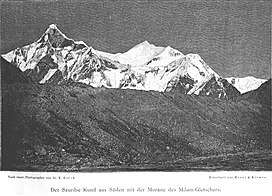
43:Hardeol (left) and Tirsuli I, photo by
273:. It rises at the northern end of the
7:
455:
453:
353:This is an approximate figure. See
534:Seven-thousanders of the Himalayas
25:
529:Geography of Pithoragarh district
391:Himalayan Journal Vol. 12, p. 65.
367:The Alpine Club's Himalayan Index
457:
429:Himalayan Mountaineering Journal
147:
140:
37:
148:
1:
401:Himalayan Association Journal
63:7,074 m (23,209 ft)
477:. You can help Knowledge by
539:Uttarakhand geography stubs
555:
452:
323:List of mountains in India
73:624 m (2,047 ft)
134:
36:
524:Mountains of Uttarakhand
277:, which drains into the
431:, Vol. 1, No.2, p. 73.
313:
311:
101:30.58000°N 80.02000°E
355:Garhwal-Himalaya Ost
342:Garhwal-Himalaya Ost
122:English translation
97: /
417:Himalayan handbook
314:
266:Sanctuary, in the
106:30.58000; 80.02000
53:Highest point
47: in 1890
486:
485:
441:Himalayan Journal
419:, Calcutta, 1979.
298:Mohan Singh Kohli
229:
228:
161:Location in India
16:(Redirected from
546:
507:
500:
493:
461:
454:
444:
438:
432:
426:
420:
410:
404:
398:
392:
389:
383:
376:
370:
364:
358:
351:
345:
339:
221:
197:Garhwal Himalaya
192:
175:Chamoli district
151:
150:
144:
112:
111:
109:
108:
107:
102:
98:
95:
94:
93:
90:
41:
29:
21:
554:
553:
549:
548:
547:
545:
544:
543:
514:
513:
512:
511:
450:
448:
447:
439:
435:
427:
423:
411:
407:
399:
395:
390:
386:
377:
373:
365:
361:
352:
348:
340:
336:
331:
319:
312:Expedition team
294:Nanda Devi East
219:
190:
166:
165:
164:
163:
162:
159:
158:
157:
156:
152:
105:
103:
99:
96:
91:
88:
86:
84:
83:
48:
45:Kurt Boeck
23:
22:
15:
12:
11:
5:
552:
550:
542:
541:
536:
531:
526:
516:
515:
510:
509:
502:
495:
487:
484:
483:
462:
446:
445:
433:
421:
413:Joydeep Sircar
405:
393:
384:
371:
359:
346:
333:
332:
330:
327:
326:
325:
318:
315:
292:expedition to
227:
226:
223:
215:
214:
211:
205:
204:
200:
199:
194:
186:
185:
172:
168:
167:
160:
154:
153:
146:
145:
139:
138:
137:
136:
135:
132:
131:
127:
126:
123:
119:
118:
114:
113:
81:
75:
74:
71:
65:
64:
61:
55:
54:
50:
49:
42:
34:
33:
24:
14:
13:
10:
9:
6:
4:
3:
2:
551:
540:
537:
535:
532:
530:
527:
525:
522:
521:
519:
508:
503:
501:
496:
494:
489:
488:
482:
480:
476:
472:
468:
463:
460:
456:
451:
442:
437:
434:
430:
425:
422:
418:
414:
409:
406:
402:
397:
394:
388:
385:
381:
375:
372:
368:
363:
360:
356:
350:
347:
343:
338:
335:
328:
324:
321:
320:
316:
310:
306:
304:
299:
295:
291:
286:
284:
280:
276:
272:
269:
265:
261:
257:
253:
249:
245:
241:
237:
233:
224:
222:
220:Easiest route
216:
212:
210:
206:
201:
198:
195:
193:
187:
184:
180:
176:
173:
169:
143:
133:
128:
124:
120:
115:
110:
82:
80:
76:
72:
70:
66:
62:
60:
56:
51:
46:
40:
35:
30:
27:
19:
479:expanding it
464:
449:
440:
436:
428:
424:
416:
408:
400:
396:
387:
379:
378:Jill Neate,
374:
362:
354:
349:
341:
337:
287:
275:Johar Valley
244:Tirsuli West
231:
230:
209:First ascent
191:Parent range
26:
471:Uttarakhand
279:Ghori Ganga
179:Uttarakhand
104: /
79:Coordinates
518:Categories
443:27, p. 67.
329:References
264:Nanda Devi
256:Changabang
92:80°01′12″E
89:30°34′48″N
69:Prominence
469:state of
403:, Vol. 2.
236:Himalayan
130:Geography
59:Elevation
317:See also
271:Himalaya
252:Dunagiri
203:Climbing
171:Location
18:Trishuli
303:Kolkata
268:Garhwal
260:Kalanka
248:Hardeol
232:Tirsuli
155:Tirsuli
125:Trident
32:Tirsuli
467:Indian
290:Polish
283:Trisul
258:, and
117:Naming
473:is a
240:India
234:is a
183:India
475:stub
305:.
520::
415:,
254:,
250:,
246:,
181:,
177:,
506:e
499:t
492:v
481:.
20:)
Text is available under the Creative Commons Attribution-ShareAlike License. Additional terms may apply.