57:
613:
640:
625:
90:
582:
597:
570:
796:
97:
64:
34:
413:, with both southern and northern species; at least 90 species of fish have been observed, and the fjord has the largest biological production among Norway's fjords. In recent years,
711:
Hamblin, Paul F.; Carmack, Eddy C. (1980). Freeland, Howard (ed.). "Mean Field
Distributions of a Dissolved Substance in the Vicinity of Branches in a Fjord System".
596:
56:
807:
827:
624:
612:
140:
728:
812:
569:
639:
89:
832:
760:
581:
822:
857:
852:
817:
800:
603:
847:
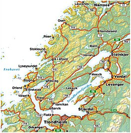
270:
432:
349:, a long and narrow fjord branch in the northern part of the fjord, might be ice covered in winter. The
887:
862:
907:
257:
867:
357:
228:
897:
724:
276:
at 130 kilometres (81 mi) long. It is located in the west-central part of the country in
872:
716:
630:
444:
419:
414:
365:
328:
236:
902:
892:
882:
361:
350:
337:
232:
877:
184:
770:
503:
have been found in the fjord, which is among the highest concentrations in the world.
841:
262:
172:
765:
395:
390:
377:
547:
277:
125:
720:
500:
459:
448:
410:
403:
385:
369:
346:
304:
297:
661:
588:
481:
399:
312:
155:
142:
656:
524:
512:
466:
436:
424:
381:
289:
285:
224:
42:
281:
795:
485:
477:
458:
The lowland east and south of the fjord represents one of Norway's best
493:
489:
440:
293:
33:
452:
428:
373:
332:
316:
308:
292:
on its way. Its maximum depth is 617 metres (2,024 ft), between
266:
190:
319:
of
Trondheim; and there are several islands at the entrance of the
542:
If this is the case, then the people living around the fjord (the
463:
431:
rivers in Norway empty into the fjord. Among these are the rivers
398:
is a peninsula along the eastern shore of the fjord where a large
320:
273:
177:
39:
808:
Norwegian
Journal of Geology:The deglaciation of Trondheimsfjord
555:
536:
470:
368:
are found on the eastern and northeastern shores of the fjord.
833:
342:
469:
lies to the west and northwest, giving some shelter from the
515:, but originally the name of the fjord might have been just
353:
might also freeze over in winter, but only for a few weeks.
423:) were discovered in the fjord, not far from the city of
535:, which means 'likeable' or 'stoutish' (and was one of
492:
that killed one person in
Trondheim and ruptured three
685:. Cambridge: Cambridge University Press. p. 156.
531:, which means to 'thrive' or 'flourish' and the name
681:
Chippindale, Christopher; Taçon, Paul S. C. (1998).
220:
216:
208:
200:
196:
183:
171:
132:
121:
21:
554:, which means 'the people living around the fjord
280:county, and it stretches from the municipality of
575:Korsvika, eastern Trondheim, view towards north.
527:. A name like that would be related to the verb
133:
818:Pictures and information about cold coral reefs
606:was moored nearby during parts of World War II.
700:. Trondheim: Tapir Academic Press. p. 27.
550:) named themselves after the fjord. (Compare
484:, as it is still today. In 1888, an undersea
8:
331:. The part of the fjord to the north of the
341:. The main part of the Trondheimsfjord is
18:
823:Coral reefs in Trondheimsfjord and Norway
435:(on the border of Melhus and Trondheim),
96:
63:
673:
565:
462:areas. The more rugged and mountainous
388:completed the luxurious apartment ship
633:, the only road crossing on the fjord.
746:Fisk og fiskerier i Trondheimsfjorden
511:The fjord is named after the city of
476:The Trondheimsfjord was an important
303:The largest islands in the fjord are
256:
7:
759:Eivindsen, TOve (21 January 2011).
284:in the west to the municipality of
618:Coastal farm area along the fjord.
288:in the north, passing the city of
14:
813:NTNU Trondhjem biological station
748:. Tapir Forlag. pp. 110–132.
794:
638:
623:
611:
595:
580:
568:
95:
88:
62:
55:
32:
698:On the Pilgrim Way to Trondheim
207:
199:
38:Map of Trondheim Fjord and the
602:Åsenfjord, near Stjørdal. The
258:[ˈtrɔ̂nː(h)æɪmsˌfjuːɳ]
1:
715:. New York: Plenum: 371–376.
409:The Trondheimsfjord has rich
120:
721:10.1007/978-1-4613-3105-6_33
683:The Archaeology of Rock-Art
204:130 kilometres (81 mi)
926:
828:The sea trees of Trondheim
587:Lighthouse and the island
212:617 metres (2,024 ft)
109:Trondheimsfjorden (Norway)
473:common to coastal areas.
49:
31:
26:
16:Body of water in Norway
858:Geography of Trondheim
427:. Several of the best
378:offshore installations
335:is referred to as the
311:; the small island of
803:at Wikimedia Commons
345:-free all year; only
79:Show map of Trøndelag
76:Location of the fjord
696:Thue, Stein (2008).
645:Harbour of Trondheim
315:is located near the
853:Fjords of Trøndelag
447:(in Stjørdal), and
261:), an inlet of the
156:63.8192°N 11.1078°E
152: /
761:"Kjempene i karet"
713:Fjord Oceanography
384:sector. A yard in
327:is crossed by the
112:Show map of Norway
801:Trondheimsfjorden
799:Media related to
730:978-1-4613-3107-0
415:deep water corals
250:Trondheimsfjorden
242:
241:
103:Trondheimsfjorden
70:Trondheimsfjorden
22:Trondheimsfjorden
915:
798:
783:
782:
780:
778:
769:. Archived from
756:
750:
749:
741:
735:
734:
708:
702:
701:
693:
687:
686:
678:
642:
631:Skarnsund Bridge
627:
615:
599:
584:
572:
420:Lophelia pertusa
329:Skarnsund Bridge
260:
255:
167:
166:
164:
163:
162:
161:63.8192; 11.1078
157:
153:
150:
149:
148:
145:
135:
113:
99:
98:
92:
80:
66:
65:
59:
36:
19:
925:
924:
918:
917:
916:
914:
913:
912:
848:Trondheimsfjord
838:
837:
792:
787:
786:
776:
774:
758:
757:
753:
743:
742:
738:
731:
710:
709:
705:
695:
694:
690:
680:
679:
675:
670:
653:
646:
643:
634:
628:
619:
616:
607:
600:
591:
585:
576:
573:
564:
539:'s nicknames).
509:
376:produces large
358:Stjørdalshalsen
351:Beitstadfjorden
338:Beitstadfjorden
253:
246:Trondheim Fjord
229:Stjørdalshalsen
187: countries
160:
158:
154:
151:
146:
143:
141:
139:
138:
117:
116:
115:
114:
111:
110:
107:
106:
105:
104:
100:
83:
82:
81:
78:
77:
74:
73:
72:
71:
67:
45:
27:Trondheim Fjord
17:
12:
11:
5:
923:
922:
919:
911:
910:
905:
900:
895:
890:
885:
880:
875:
870:
865:
860:
855:
850:
840:
839:
836:
835:
830:
825:
820:
815:
810:
791:
790:External links
788:
785:
784:
773:on 18 May 2011
751:
736:
729:
703:
688:
672:
671:
669:
666:
665:
664:
659:
652:
649:
648:
647:
644:
637:
635:
629:
622:
620:
617:
610:
608:
601:
594:
592:
586:
579:
577:
574:
567:
563:
560:
508:
505:
240:
239:
222:
218:
217:
214:
213:
210:
206:
205:
202:
198:
197:
194:
193:
188:
181:
180:
175:
169:
168:
136:
130:
129:
128:county, Norway
123:
119:
118:
108:
102:
101:
94:
93:
87:
86:
85:
84:
75:
69:
68:
61:
60:
54:
53:
52:
51:
50:
47:
46:
37:
29:
28:
24:
23:
15:
13:
10:
9:
6:
4:
3:
2:
921:
920:
909:
906:
904:
901:
899:
896:
894:
891:
889:
886:
884:
881:
879:
876:
874:
871:
869:
866:
864:
861:
859:
856:
854:
851:
849:
846:
845:
843:
834:
831:
829:
826:
824:
821:
819:
816:
814:
811:
809:
806:
805:
804:
802:
797:
789:
772:
768:
767:
762:
755:
752:
747:
740:
737:
732:
726:
722:
718:
714:
707:
704:
699:
692:
689:
684:
677:
674:
667:
663:
660:
658:
655:
654:
650:
641:
636:
632:
626:
621:
614:
609:
605:
598:
593:
590:
583:
578:
571:
566:
562:Media gallery
561:
559:
557:
553:
549:
545:
540:
538:
534:
530:
526:
522:
518:
514:
506:
504:
502:
497:
495:
491:
487:
483:
479:
474:
472:
468:
465:
461:
456:
454:
450:
446:
445:Stjørdalselva
442:
438:
434:
430:
426:
422:
421:
416:
412:
407:
405:
401:
397:
393:
392:
387:
383:
379:
375:
371:
367:
363:
359:
356:The towns of
354:
352:
348:
344:
340:
339:
334:
330:
326:
323:. The narrow
322:
318:
314:
310:
306:
301:
299:
295:
291:
287:
283:
279:
275:
272:
271:third-longest
268:
264:
263:Norwegian Sea
259:
251:
247:
238:
234:
230:
226:
223:
219:
215:
211:
203:
195:
192:
189:
186:
182:
179:
176:
174:
170:
165:
137:
131:
127:
124:
91:
58:
48:
44:
41:
35:
30:
25:
20:
793:
775:. Retrieved
771:the original
766:Forskning.no
764:
754:
745:
739:
712:
706:
697:
691:
682:
676:
551:
543:
541:
532:
528:
520:
516:
510:
498:
475:
460:agricultural
457:
418:
408:
406:is located.
396:Fiborgtangen
391:MS The World
389:
355:
336:
324:
302:
249:
245:
243:
863:Indre Fosen
501:giant squid
449:Verdalselva
411:marine life
404:Norske Skog
386:Indre Fosen
370:Aker Verdal
347:Verrasundet
325:Skarnsundet
298:Indre Fosen
221:Settlements
201:Max. length
159: /
134:Coordinates
842:Categories
777:22 January
668:References
662:Petter Lie
589:Munkholmen
482:Viking Age
400:paper mill
313:Munkholmen
254:pronounced
209:Max. depth
147:11°06′28″E
144:63°49′09″N
908:Steinkjer
744:Mork, J.
657:Ellen Lie
548:Trøndelag
525:Old Norse
513:Trondheim
488:caused a
467:peninsula
437:Orklaelva
425:Trondheim
402:owned by
382:petroleum
366:Steinkjer
290:Trondheim
286:Steinkjer
278:Trøndelag
237:Steinkjer
225:Trondheim
126:Trøndelag
43:peninsula
898:Levanger
888:Stjørdal
651:See also
486:mudslide
478:waterway
380:for the
362:Levanger
305:Ytterøya
233:Levanger
122:Location
873:Orkland
604:Tirpitz
544:þrœndir
521:*Þróund
496:lines.
494:railway
490:tsunami
480:in the
441:Orkland
294:Orkland
903:Verdal
893:Frosta
883:Malvik
868:Ørland
727:
552:sygnir
546:; see
529:þróast
517:*Þrónd
453:Verdal
429:salmon
374:Verdal
364:, and
333:strait
317:harbor
309:Tautra
282:Ørland
267:Norway
191:Norway
878:Skaun
499:Four
464:Fosen
433:Gaula
321:fjord
274:fjord
265:, is
185:Basin
178:Fjord
40:Fosen
779:2011
725:ISBN
558:'.)
556:Sogn
537:Odin
533:Þrór
507:Name
471:wind
451:(in
439:(in
307:and
296:and
244:The
173:Type
717:doi
523:in
519:or
455:).
443:),
372:in
343:ice
269:'s
248:or
844::
763:.
723:.
394:.
360:,
300:.
235:,
231:,
227:,
781:.
733:.
719::
417:(
252:(
Text is available under the Creative Commons Attribution-ShareAlike License. Additional terms may apply.