400:
34:
424:
412:
448:
460:
270:
436:
472:
51:
76:
484:
367:
83:
58:
358:
The official name usage for the falls is confusing as most maps produced by the
Government of the Province of Nova Scotia and by many tourist groups use either of the two spellings starting with a "U", sometimes using both spellings in the same document, yet the only official name that appears in
383:
The waterfall is accessible by trail. The Falls Trail is approximately 3.0 kilometres (1.8 miles) in length (round trip), and requires about one hour to complete. The trail passes through a field then follows Falls Brook upstream through a mixed forest and then a climax hardwood forest composed
334:
Easach Ban lies in a steep-sided river canyon, part of the landscape which forms the interface between the elevated Cape Breton Boreal
Plateau and the lower Central Cape Breton Hills landscapes. Major river systems, such as the Baddeck River of which Easach Ban is part, originate on the boreal
335:
plateau, plunge down the steep slopes (approximately 300 metres (980 ft) in height), to eventually empty into the Bras d'Or Lakes. Rock types of this landscape are similar to those found in the boreal plateau - derived ancient granite, gneiss, and schist.
338:
The Easach Ban canyon is filled by deciduous, coniferous, and mixed forests. Dominant tree species include sugar maple, yellow birch, beech, white spruce, and balsam fir. Provincially rare and uncommon plants occur in this canyon.
384:
largely of maple, birch, and beech. The deep stream valley narrows dramatically in the vicinity of Uisge Ban
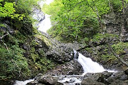
Waterfall. At the falls, the sheer walls of the gorge tower 150 metres (500 feet) on either side.
387:
The original trail was developed with assistance from the Nova Scotia Forest
Technicians Association. Recent improvements were undertaken by Stora Enso and the Nova Scotia Department of Natural Resources.
1009:
315:
The landscape surrounding Easach Ban is a product or incredibly powerful forces which have shaped and reshaped the area over 5 billion years. Formation of the earth's landmass, tremendous
718:
1014:
948:
658:
814:
399:
133:
447:
423:
411:
50:
435:
913:
459:
1004:
626:
525:
471:
75:
765:
738:
723:
576:
246:
107:
33:
938:
363:
is the "Easach Ban" spelling. The "Easach Ban" spelling is the only version used on
Government of Canada topographical maps.
307:
waterfall dropping 16 metres (52 ft) in multiple steps, with a pool 2/3 of the way down, between sections of the falls.
973:
759:
254:
126:
299:
Easach Ban drops over 100 metres (330 ft) over a run of 715 metres (2,346 ft). While most of Easach Ban is a
743:
713:
781:
678:
483:
269:
708:
698:
668:
360:
908:
863:
978:
958:
953:
928:
893:
883:
693:
250:
111:
903:
888:
878:
776:
371:
923:
868:
619:
838:
289:
258:
234:
829:
943:
898:
873:
683:
644:
510:
688:
968:
824:
293:
612:
207:
804:
728:
663:
918:
771:
703:
593:
366:
229:(official spelling "Easach Ban" alternative spellings "Uisage"; "Bàn" or "Bahn") is a
998:
963:
933:
847:
809:
673:
983:
579:: Parks and Recreation Division, Nova Scotia Department of Natural Resources. 2014.
550:
238:
115:
799:
328:
148:
135:
599:
304:
300:
230:
165:
635:
370:
ca. 1900 A scrapbook image of Uisge Ban Falls. Item was donated to the
324:
320:
316:
242:
119:
365:
268:
526:"Provincial Hiking Trails of Victoria County, Cape Breton Island"
819:
347:
The name Uisge Ban comes from the Gaelic meaning “white water”,
608:
596:(listed as Easach Ban - links to a detailed topographical map)
604:
359:
either
Government of Nova Scotia or Government of Canada,
331:, have all played a role in shaping this landscape.
1010:
Tourist attractions in
Victoria County, Nova Scotia
856:
790:
752:
651:
216:
206:
198:
190:
182:
174:
164:
125:
103:
21:
520:
518:
719:Saint Peter's and Saint John's Anglican Church
620:
553:. Nova Scotia Health Promotion and Protection
361:Canadian Geographical Names Data Base (CGNDB)
8:
659:Alexander Graham Bell National Historic Site
506:
504:
815:Canadian Aerodrome Baddeck No. 1 and No. 2
627:
613:
605:
32:
18:
1015:Landforms of Victoria County, Nova Scotia
575:(Interpretive Panel at park trail head).
551:"Map of: Uisge Ban Falls Provincial Park"
511:Geographical Names of Canada - Easach Ban
303:, there is a prominent section that is a
194:2 prominent horsetail drops, plus cascade
38:Easach Ban, Victoria County, Nova Scotia
500:
395:
82:
57:
257:, 14.5 kilometres (9 miles) north of
7:
351:, probably conflated with the word
14:
482:
470:
458:
446:
434:
422:
410:
398:
81:
74:
56:
49:
16:Waterfall in Nova Scotia, Canada
766:Baddeck, And That Sort of Thing
739:Uisge Ban Falls Provincial Park
724:Spectacle Island Game Sanctuary
600:Uisge Ban Falls - Moosebait.com
577:Uisge Ban Falls Provincial Park
531:. Nova Scotia Natural Resources
247:Uisge Ban Falls Provincial Park
215:
189:
181:
173:
108:Uisge Ban Falls Provincial Park
939:John Alexander Douglas McCurdy
594:Nova Scotia Geographical Names
1:
760:Aerial Experiment Association
441:New Bridge on the Falls Trail
374:by Malcolm McNeil of Boston.
744:Victoria County Court House
489:Upper falls in October 2014
319:, collision of continents,
280:is a section of the longer
273:The Falls in September 2012
1031:
782:Canadian Aerodrome Company
679:Beinn Bhreagh, Nova Scotia
286:North Branch Baddeck River
245:. The falls is located in
212:715 metres (2,346 ft)
1005:Waterfalls of Nova Scotia
709:Kidston Island Lighthouse
699:Gilbert H. Grosvenor Hall
669:Baddeck (Guneden) Airport
642:
372:Beaton Institute Archives
149:46.2134861°N 60.7920306°W
99:
43:
31:
26:
864:Frederick Walker Baldwin
714:St. Mark's Masonic Lodge
477:Upper falls at low water
186:100 metres (330 ft)
178:200 metres (660 ft)
979:Barclay Edmund Tremaine
959:Aulay MacAulay Morrison
954:James Charles McKeagney
949:John Archibald McDonald
929:Arthur Williams McCurdy
894:Gilbert Hovey Grosvenor
889:Simon Gibbons, Reverend
284:, which flows into the
154:46.2134861; -60.7920306
65:Show map of Nova Scotia
904:Mabel Gardiner Hubbard
879:Charles James Campbell
777:Cabot Trail Relay Race
375:
274:
202:16 metres (52 ft)
924:Carleton L. MacMillan
869:Alexander Graham Bell
453:Along the Falls Trail
429:Along the Falls Trail
417:Along the Falls Trail
405:Along the Falls Trail
369:
355:meaning a waterfall.
272:
753:Articles of interest
694:Bras d'Or Yacht Club
652:Places and buildings
290:St. Patricks Channel
288:, and eventually to
145: /
27:Uisge Ban Waterfall
944:William F. McCurdy
899:Mabel H. Grosvenor
874:H. Percy Blanchard
793:related to Baddeck
791:Ships and aircraft
684:Bell Bay Golf Club
376:
275:
170:Plunge and Cascade
90:Show map of Canada
992:
991:
969:Michael A. Newton
857:Notable residents
825:Hubbard Monoplane
321:mountain-building
317:volcanic activity
224:
223:
1022:
629:
622:
615:
606:
581:
580:
569:
563:
562:
560:
558:
547:
541:
540:
538:
536:
530:
522:
513:
508:
486:
474:
462:
450:
438:
426:
414:
402:
160:
159:
157:
156:
155:
150:
146:
143:
142:
141:
138:
91:
85:
84:
78:
66:
60:
59:
53:
36:
19:
1030:
1029:
1025:
1024:
1023:
1021:
1020:
1019:
995:
994:
993:
988:
914:William Kidston
852:
805:AEA Silver Dart
792:
786:
748:
734:Uisge Ban Falls
729:Telegraph House
689:Bras d'Or House
664:Baddeck Academy
647:
638:
633:
590:
585:
584:
573:Uisge Ban Falls
571:
570:
566:
556:
554:
549:
548:
544:
534:
532:
528:
524:
523:
516:
509:
502:
497:
490:
487:
478:
475:
466:
463:
454:
451:
442:
439:
430:
427:
418:
415:
406:
403:
394:
381:
379:The Falls Trail
345:
313:
311:Natural history
267:
255:Victoria County
227:Uisge Ban Falls
191:Number of drops
153:
151:
147:
144:
139:
136:
134:
132:
131:
95:
94:
93:
92:
89:
88:
87:
86:
69:
68:
67:
64:
63:
62:
61:
39:
17:
12:
11:
5:
1028:
1026:
1018:
1017:
1012:
1007:
997:
996:
990:
989:
987:
986:
981:
976:
974:George W. Rice
971:
966:
961:
956:
951:
946:
941:
936:
931:
926:
921:
919:Moses E. Kiley
916:
911:
906:
901:
896:
891:
886:
881:
876:
871:
866:
860:
858:
854:
853:
851:
850:
845:
836:
827:
822:
817:
812:
807:
802:
796:
794:
788:
787:
785:
784:
779:
774:
772:Celtic Colours
769:
762:
756:
754:
750:
749:
747:
746:
741:
736:
731:
726:
721:
716:
711:
706:
704:Kidston Island
701:
696:
691:
686:
681:
676:
671:
666:
661:
655:
653:
649:
648:
643:
640:
639:
634:
632:
631:
624:
617:
609:
603:
602:
597:
589:
588:External links
586:
583:
582:
564:
542:
514:
499:
498:
496:
493:
492:
491:
488:
481:
479:
476:
469:
467:
464:
457:
455:
452:
445:
443:
440:
433:
431:
428:
421:
419:
416:
409:
407:
404:
397:
393:
390:
380:
377:
344:
341:
312:
309:
294:Bras d'Or Lake
266:
263:
222:
221:
218:
214:
213:
210:
204:
203:
200:
196:
195:
192:
188:
187:
184:
180:
179:
176:
172:
171:
168:
162:
161:
129:
123:
122:
105:
101:
100:
97:
96:
80:
79:
73:
72:
71:
70:
55:
54:
48:
47:
46:
45:
44:
41:
40:
37:
29:
28:
24:
23:
15:
13:
10:
9:
6:
4:
3:
2:
1027:
1016:
1013:
1011:
1008:
1006:
1003:
1002:
1000:
985:
982:
980:
977:
975:
972:
970:
967:
965:
964:Kendall Myers
962:
960:
957:
955:
952:
950:
947:
945:
942:
940:
937:
935:
934:David McCurdy
932:
930:
927:
925:
922:
920:
917:
915:
912:
910:
909:George Kennan
907:
905:
902:
900:
897:
895:
892:
890:
887:
885:
882:
880:
877:
875:
872:
870:
867:
865:
862:
861:
859:
855:
849:
848:Bell Boatyard
846:
844:
842:
837:
835:
833:
828:
826:
823:
821:
818:
816:
813:
811:
810:Bell Oionus I
808:
806:
803:
801:
798:
797:
795:
789:
783:
780:
778:
775:
773:
770:
768:
767:
763:
761:
758:
757:
755:
751:
745:
742:
740:
737:
735:
732:
730:
727:
725:
722:
720:
717:
715:
712:
710:
707:
705:
702:
700:
697:
695:
692:
690:
687:
685:
682:
680:
677:
675:
674:Baddeck River
672:
670:
667:
665:
662:
660:
657:
656:
654:
650:
646:
641:
637:
630:
625:
623:
618:
616:
611:
610:
607:
601:
598:
595:
592:
591:
587:
578:
574:
568:
565:
552:
546:
543:
527:
521:
519:
515:
512:
507:
505:
501:
494:
485:
480:
473:
468:
461:
456:
449:
444:
437:
432:
425:
420:
413:
408:
401:
396:
391:
389:
385:
378:
373:
368:
364:
362:
356:
354:
350:
342:
340:
336:
332:
330:
326:
322:
318:
310:
308:
306:
302:
297:
295:
291:
287:
283:
279:
271:
264:
262:
260:
256:
252:
248:
244:
240:
236:
232:
228:
219:
211:
209:
205:
201:
197:
193:
185:
177:
169:
167:
163:
158:
140:60°47′31.31″W
137:46°12′48.55″N
130:
128:
124:
121:
117:
113:
109:
106:
102:
98:
77:
52:
42:
35:
30:
25:
20:
984:Jessica Wong
884:Rachel Davis
840:
831:
764:
733:
572:
567:
555:. Retrieved
545:
533:. Retrieved
386:
382:
357:
352:
348:
346:
337:
333:
314:
298:
285:
281:
277:
276:
226:
225:
199:Longest drop
183:Total height
465:Lower Falls
282:Falls Brook
265:Description
239:Nova Scotia
220:Falls Brook
217:Watercourse
152: /
127:Coordinates
116:Nova Scotia
999:Categories
800:AEA Cygnet
495:References
329:glaciation
323:, massive
278:Easach Ban
22:Easach Ban
349:uisge bàn
305:horsetail
231:waterfall
175:Elevation
557:March 7,
251:New Glen
112:New Glen
104:Location
843:(R-103)
841:Baddeck
832:Baddeck
645:History
636:Baddeck
535:8 April
392:Gallery
325:erosion
301:cascade
292:of the
259:Baddeck
235:Baddeck
834:(K147)
243:Canada
120:Canada
839:HMCS
830:HMCS
529:(PDF)
249:near
233:near
820:HD-4
559:2012
537:2017
343:Name
327:and
166:Type
353:eas
208:Run
1001::
517:^
503:^
296:.
261:.
253:,
241:,
237:,
118:,
114:,
110:,
628:e
621:t
614:v
561:.
539:.
Text is available under the Creative Commons Attribution-ShareAlike License. Additional terms may apply.