54:
704:
277:
42:
373:
The township is governed by a three-member board of trustees, who are elected in
November of odd-numbered years to a four-year term beginning on the following January 1. Two are elected in the year after the presidential election and one is elected in the year before it. There is also an elected
374:
township fiscal officer, who serves a four-year term beginning on April 1 of the year after the election, which is held in
November of the year before the presidential election. Vacancies in the fiscal officership or on the board of trustees are filled by the remaining trustees.
264:, United States, located in the central part of the county. It was established January 3, 1815 and named Union as it was formed from parts of Deerfield and Turtlecreek Townships. The population was 6,251 as of the
315:
The smallest township in the county, it originally had fifteen full and six fractional sections of land totaling 11,970 acres (48 km). However, a large portion of the township has been annexed into
53:
328:. The village of South Lebanon remains within the township, but Mason and Lebanon are not and that land has been lost. The township is prone to flooding from the Little Miami and
67:
1163:
597:
350:
1148:
812:
287:
822:
777:
782:
354:
308:
227:
792:
787:
299:
342:
1158:
802:
797:
827:
807:
293:
237:
433:
405:
590:
329:
41:
997:
845:
202:
481:
452:
1032:
583:
425:
575:
507:
1153:
1090:
1017:
1057:
429:
421:
346:
265:
123:
99:
1047:
947:
937:
837:
408:
crossed the township, but all track southeast of US 42 has been abandoned and lifted. The city of
Lebanon's
1075:
1125:
754:
212:
276:
1118:
972:
881:
865:
664:
607:
397:
317:
257:
128:
1080:
1037:
987:
982:
967:
952:
922:
303:
424:, which was formerly known as the Deerfield-Union Local School District, while parts are in the
1085:
1042:
855:
759:
739:
729:
723:
555:
528:
387:
1027:
992:
912:
896:
871:
744:
692:
680:
530:
The
History of Warren County, Ohio: Containing a History of the County; Its Townships, Towns
409:
962:
942:
907:
902:
891:
336:
1022:
1007:
932:
769:
715:
669:
654:
648:
253:
32:
1142:
1095:
1052:
1012:
1002:
927:
659:
629:
401:
393:
321:
104:
860:
850:
749:
734:
686:
383:
977:
957:
917:
675:
640:
622:
325:
283:
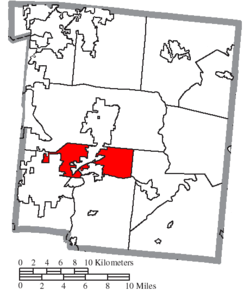
Located in the central part of the county, it borders the following townships:
1067:
111:
82:
69:
193:
1109:‡This populated place also has portions in an adjacent county or counties
382:
Telephone service is provided through South
Lebanon, Lebanon, Mason, and
551:
547:
543:
339:
and was surveyed in accordance with the unusual plan Symmes chose.
275:
219:
198:
261:
116:
579:
703:
570:
453:"Union Township, Warren County, Ohio - Census Bureau Profile"
702:
477:
404:
clips the northwest corner of the township. Formerly, the
503:
396:
crosses the township from southwest to northeast and
412:
is in Union
Township, along the Little Miami River.
1104:
1066:
880:
836:
768:
714:
639:
236:
226:
209:
192:
184:
176:
171:
163:
155:
147:
139:
134:
122:
110:
98:
23:
533:. W.H. Beers & Company. 1882. p. 710.
390:, and Morrow post offices serve the township.
591:
386:exchanges, while the South Lebanon, Lebanon,
8:
58:Location of Union Township in Warren County
598:
584:
576:
20:
444:
225:
191:
170:
162:
133:
97:
62:
50:
38:
707:Map of Ohio highlighting Warren County
365:Union Township was organized in 1815.
472:
470:
235:
208:
183:
175:
154:
146:
138:
121:
109:
7:
1164:Populated places established in 1815
46:Open land just east of South Lebanon
151:14.7 sq mi (37.9 km)
143:14.7 sq mi (38.2 km)
25:Union Township, Warren County, Ohio
606:Municipalities and communities of
434:Little Miami Local School District
406:Middletown and Cincinnati Railroad
14:
159:0.1 sq mi (0.2 km)
1149:Townships in Warren County, Ohio
347:third most popular township name
52:
40:
482:United States Geological Survey
420:Most of the township is in the
18:Township in Ohio, United States
478:"US Board on Geographic Names"
335:The entire township is in the
1:
455:. United States Census Bureau
426:Lebanon City School District
349:statewide; only Washington (
1159:1815 establishments in Ohio
508:United States Census Bureau
422:Kings Local School District
188:318.6/sq mi (123.0/km)
1180:
430:Mason City School District
1114:
700:
620:
63:
51:
39:
30:
167:630 ft (192 m)
708:
410:sewage treatment plant
280:
706:
558:. Accessed 4/30/2009.
504:"U.S. Census website"
400:from south to north.
279:
252:is one of the eleven
211: • Summer (
83:39.38111°N 84.22444°W
1127:United States portal
1091:Hammel and Millgrove
302:- south, across the
288:Turtlecreek Township
185: • Density
609:Warren County, Ohio
357:) are more common.
88:39.38111; -84.22444
79: /
709:
484:. October 25, 2007
309:Deerfield Township
304:Little Miami River
281:
177: • Total
156: • Water
140: • Total
1154:Townships in Ohio
1136:
1135:
1048:Twenty Mile Stand
948:Hagemans Crossing
938:Greentree Corners
556:Ohio Revised Code
300:Hamilton Township
247:
246:
148: • Land
1171:
1128:
1121:
705:
632:
625:
615:
610:
600:
593:
586:
577:
559:
541:
535:
534:
525:
519:
518:
516:
514:
500:
494:
493:
491:
489:
474:
465:
464:
462:
460:
449:
216:
94:
93:
91:
90:
89:
84:
80:
77:
76:
75:
72:
56:
44:
21:
1179:
1178:
1174:
1173:
1172:
1170:
1169:
1168:
1139:
1138:
1137:
1132:
1126:
1119:
1110:
1100:
1076:Beedles Station
1062:
883:
876:
832:
764:
710:
698:
635:
630:
623:
616:
613:
608:
604:
567:
562:
542:
538:
527:
526:
522:
512:
510:
502:
501:
497:
487:
485:
476:
475:
468:
458:
456:
451:
450:
446:
442:
418:
380:
378:Public services
371:
363:
353:) and Jackson (
337:Symmes Purchase
274:
210:
87:
85:
81:
78:
73:
70:
68:
66:
65:
59:
47:
35:
26:
19:
12:
11:
5:
1177:
1175:
1167:
1166:
1161:
1156:
1151:
1141:
1140:
1134:
1133:
1131:
1130:
1123:
1115:
1112:
1111:
1108:
1106:
1102:
1101:
1099:
1098:
1093:
1088:
1083:
1078:
1072:
1070:
1064:
1063:
1061:
1060:
1055:
1050:
1045:
1040:
1035:
1030:
1025:
1020:
1015:
1010:
1005:
1000:
995:
990:
985:
980:
975:
970:
965:
960:
955:
950:
945:
940:
935:
930:
925:
920:
915:
910:
905:
900:
894:
888:
886:
882:Unincorporated
878:
877:
875:
874:
869:
863:
858:
853:
848:
842:
840:
834:
833:
831:
830:
825:
820:
815:
810:
805:
800:
795:
790:
785:
780:
774:
772:
766:
765:
763:
762:
757:
755:Pleasant Plain
752:
747:
742:
737:
732:
727:
720:
718:
712:
711:
701:
699:
697:
696:
690:
684:
678:
673:
667:
662:
657:
652:
645:
643:
637:
636:
621:
618:
617:
605:
603:
602:
595:
588:
580:
574:
573:
571:County website
566:
565:External links
563:
561:
560:
536:
520:
495:
466:
443:
441:
438:
417:
414:
398:State Route 48
379:
376:
370:
367:
362:
359:
313:
312:
306:
297:
294:Salem Township
291:
273:
270:
250:Union Township
245:
244:
241:
234:
233:
230:
224:
223:
217:
207:
206:
196:
190:
189:
186:
182:
181:
178:
174:
173:
169:
168:
165:
161:
160:
157:
153:
152:
149:
145:
144:
141:
137:
136:
132:
131:
126:
120:
119:
114:
108:
107:
102:
96:
95:
61:
60:
57:
49:
48:
45:
37:
36:
31:
28:
27:
24:
17:
13:
10:
9:
6:
4:
3:
2:
1176:
1165:
1162:
1160:
1157:
1155:
1152:
1150:
1147:
1146:
1144:
1129:
1124:
1122:
1117:
1116:
1113:
1107:
1103:
1097:
1094:
1092:
1089:
1087:
1084:
1082:
1079:
1077:
1074:
1073:
1071:
1069:
1065:
1059:
1056:
1054:
1051:
1049:
1046:
1044:
1041:
1039:
1036:
1034:
1031:
1029:
1026:
1024:
1021:
1019:
1016:
1014:
1011:
1009:
1006:
1004:
1001:
999:
996:
994:
991:
989:
986:
984:
981:
979:
976:
974:
973:Kenricksville
971:
969:
966:
964:
961:
959:
956:
954:
951:
949:
946:
944:
941:
939:
936:
934:
931:
929:
926:
924:
921:
919:
916:
914:
911:
909:
906:
904:
901:
898:
895:
893:
890:
889:
887:
885:
879:
873:
870:
867:
866:Loveland Park
864:
862:
859:
857:
854:
852:
849:
847:
844:
843:
841:
839:
835:
829:
826:
824:
821:
819:
816:
814:
811:
809:
806:
804:
801:
799:
796:
794:
791:
789:
786:
784:
781:
779:
776:
775:
773:
771:
767:
761:
758:
756:
753:
751:
748:
746:
743:
741:
738:
736:
733:
731:
728:
725:
722:
721:
719:
717:
713:
694:
691:
688:
685:
682:
679:
677:
674:
671:
668:
666:
665:South Lebanon
663:
661:
658:
656:
653:
650:
647:
646:
644:
642:
638:
634:
633:
626:
619:
614:United States
611:
601:
596:
594:
589:
587:
582:
581:
578:
572:
569:
568:
564:
557:
553:
549:
545:
540:
537:
532:
531:
524:
521:
509:
505:
499:
496:
483:
479:
473:
471:
467:
454:
448:
445:
439:
437:
435:
431:
427:
423:
415:
413:
411:
407:
403:
402:U.S. Route 42
399:
395:
394:Interstate 71
391:
389:
385:
377:
375:
368:
366:
360:
358:
356:
352:
348:
344:
340:
338:
333:
331:
327:
323:
319:
318:South Lebanon
310:
307:
305:
301:
298:
295:
292:
289:
286:
285:
284:
278:
271:
269:
267:
263:
259:
258:Warren County
255:
251:
242:
239:
231:
229:
221:
218:
214:
204:
203:Eastern (EST)
200:
197:
195:
187:
179:
166:
158:
150:
142:
130:
127:
125:
118:
115:
113:
106:
105:United States
103:
101:
92:
64:Coordinates:
55:
43:
34:
29:
22:
16:
1081:Browns Store
1038:San Mar Gale
988:Merrittstown
983:Mathers Mill
968:Hopkinsville
953:Hickoryville
923:Edwardsville
817:
628:
539:
529:
523:
511:. Retrieved
498:
486:. Retrieved
457:. Retrieved
447:
419:
392:
381:
372:
364:
355:37 townships
351:43 townships
341:
334:
330:Turtle Creek
314:
282:
249:
248:
15:
1120:Ohio portal
1086:Butterworth
1068:Ghost towns
1043:Socialville
998:Mount Holly
884:communities
856:Kings Mills
846:Five Points
813:Turtlecreek
760:Waynesville
740:Harveysburg
730:Butlerville
724:Blanchester
624:County seat
513:January 31,
488:January 31,
388:Kings Mills
311:- southwest
266:2020 census
86: /
1143:Categories
1028:Ridgeville
993:Middleboro
913:Dallasburg
897:Chautauqua
872:Roachester
823:Washington
778:Clearcreek
745:Maineville
693:Springboro
681:Middletown
440:References
432:, and the
369:Government
240:feature ID
172:Population
74:84°13′28″W
71:39°22′52″N
1105:Footnotes
963:Hillcrest
943:Gum Grove
908:Crosswick
903:Cozaddale
892:Blackhawk
783:Deerfield
770:Townships
459:March 24,
416:Education
272:Geography
254:townships
228:FIPS code
194:Time zone
164:Elevation
1033:Rossburg
1023:Red Lion
1008:Oregonia
933:Genntown
793:Hamilton
788:Franklin
716:Villages
670:Loveland
655:Franklin
649:Carlisle
232:39-78610
33:Township
1096:Venable
1053:Wellman
1013:Osceola
1003:Murdoch
928:Fosters
660:Lebanon
631:Lebanon
554:of the
552:§507.01
548:§505.01
544:§503.24
361:History
345:is the
322:Lebanon
290:- north
243:1087121
100:Country
861:Landen
851:Hunter
803:Massie
798:Harlan
750:Morrow
735:Corwin
687:Monroe
641:Cities
550:, and
428:, the
384:Morrow
324:, and
296:- east
129:Warren
124:County
1018:Pekin
978:Level
958:Hicks
918:Dodds
828:Wayne
818:Union
808:Salem
676:Mason
343:Union
326:Mason
222:(EDT)
220:UTC-4
199:UTC-5
180:6,251
112:State
1058:Zoar
838:CDPs
515:2008
490:2008
461:2023
262:Ohio
238:GNIS
135:Area
117:Ohio
256:of
213:DST
1145::
627::
612:,
546:,
506:.
480:.
469:^
436:.
332:.
320:,
268:.
260:,
899:‡
868:‡
726:‡
695:‡
689:‡
683:‡
672:‡
651:‡
599:e
592:t
585:v
517:.
492:.
463:.
215:)
205:)
201:(
Text is available under the Creative Commons Attribution-ShareAlike License. Additional terms may apply.