742:
91:
805:
72:
967:. Smaller but major arterial roads on the Upper North Shore include the Eastern Arterial Road/Archbold Road at St Ives, East Killara and East Lindfield, the Comenarra Parkway at Thornleigh, Wahroonga, Turramurra, South Turramurra and West Pymble, as well as Lady Game Drive at West Pymble, Gordon, Killara, Lindfield and West Chastwood, providing access to major commercial hubs such as Chatswood.
98:
591:. It is a customary term, not administrative or legal, and its boundaries are not definitive. Generally, the "North Shore" includes the peninsula north of Sydney Harbour and is bounded in the west by the Lane Cove River/National Park, in the north west by the M1 motorway to Newcastle, in the southeast by Middle Harbour, and in the northeast by
576:
1168:
The
Willoughby Spring Festival is held throughout the Willoughby local government area, in September each year. The festival lasts for a month and features over 40 events including live music/entertainment, exhibitions, cultural celebrations, business events and many more community activities. The
1164:
The North Shore holds a number of festivals/events throughout the year, including: Tartan Day at Lane Cove, the
Guringgai Festival honouring northern Sydney's Aboriginal people, the Moocooboola Festival at Hunters Hill, the Mosman Festival, Lane Cove's Cammeraygal Festival, and Chinese New Year at
1068:
The North Shore's largest commercial centres are at North Sydney and
Chatswood. A number of international companies have their Australian or Asia–Pacific Headquarters in this part of Sydney. North Sydney does not have any of Sydney's major shopping centres, however, it has a number of speciality
867:
decided to abandon the forced merger of the North Sydney, Willoughby and Mosman local government areas. The other lower north shore council, Lane Cove, was similarly proposed to be merged with nearby
Hunters Hill and Ryde councils, but that plan was also eventually abandoned.
544:. The north shore was more rugged than the southern shore and western areas of the harbour and had limited agricultural potential. The early activities in the area included tree felling, boatbuilding and some orchard farming in the limited areas of good soil. The
1298:
receives one of the highest rainfalls in the Sydney area, with an average of 1,400 millimetres (55 in) per year. The inland parts of the North Shore are somewhat cooler than other areas of the surrounding Sydney basin in the winter months, particularly the
1169:
highlight is the annual
Willoughby Street Fair where the Chatswood CBD is taken over by market stalls, performers, dancers and musicians. The StreetFair features the Willoughby Street Parade which included over 1,000 participants in 2007.
795:
decided to abandon the forced merger of the
Hornsby and Ku-ring-gai local government areas, along with several other proposed forced mergers on the North Shore following backlash from members of the community and court proceedings.
1940:
1085:. Macquarie Park also has a substantial amount of high density residential buildings and office space. St Leonards is another large commercial area featuring mostly office space and apartments.
487:. The Cammeraygal people lived in the area until the 1820s and are recorded as being in the northern parts of the Sydney region for approximately 5,800 years. The Lower North Shore suburb of
1165:
Chatswood. Mosman, North Sydney, Willoughby also hold an annual art prize. All local government areas in the region and around the country celebrate
Australia Day, which is on 26 January.
777:. It roughly corresponds with the cadastral Parish of Gordon. Sometimes, all suburbs adjoining the upper section of Lane Cove National Park are considered part of the Upper North Shore.
1069:
stores and cafés. Chatswood is one of the largest retail precincts in Sydney, and has a large amount of high density residential buildings. It is home to large shopping centres such as
1745:
559:
Four of the five local government areas that form the Lower North Shore (the City of
Willoughby and the municipalities of Mosman, Lane Cove and North Sydney) were created from the
2143:
306:
249:
788:, the local government area of Ku-ring-gai Council, which makes up almost the entirety of the Upper North Shore region, is the wealthiest local government area in Australia.
676:, the suburbs in that parish along the northern shore of the Parramatta River are sometimes referred (especially in commercial contexts) as part of the Lower North Shore.
648:
However, these boundaries are not fixed, and those suburbs that sit close to the boundary between, for example, the cadastral Parish of Gordon and the neighbouring
1944:
1979:
863:
In 2016, the NSW government proposed merging three of the four lower north shore councils (Mosman, Willoughby, and North Sydney councils). In July 2017, the
1129:
in North Sydney, Lane Cove Plaza, Zenith Towers at
Chatswood, Northpoint Tower in North Sydney, Cammeray suspension bridge at Cammeray, Echo Point Park in
652:
in the east, may be identified in different contexts as part of either the Upper North Shore region or the
Northern Beaches region. The entirety of the
2333:
190:
2227:
528:
After the British establishment of Sydney in 1788, settlement on the North Shore of the harbour was quite limited. One of the first settlers was
128:
2096:
2015:
2157:
1699:
1121:. At a Sydney or local level, however, landmarks are more plentiful and include: The Lane Cove Azalea Beds, Blues Point Tower, Eden Gardens,
792:
1233:
1003:
563:, a cadastral unit used for land titles that was created in the early years of European settlement. "North Sydney" was formerly known as
90:
2426:
766:
79:
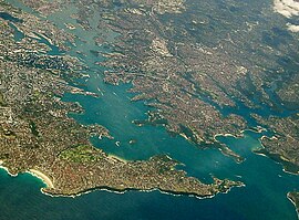
with the North Shore extending from its northern side (right) with Sydney CBD (left) and Eastern Suburbs (bottom) on its southern shore.
1122:
267:
257:
28:
741:
448:
The term "North Shore", used to describe this region of Sydney is customary, not legal or administrative, and is often subjective.
1037:
Many bus routes also serve the area, particularly the lower North Shore, and ferries connect many of the harbourside suburbs with
2406:
2361:
2257:
1300:
1288:
1209:
Throughout history and on all three levels of politics (federal, state and local), the North Shore has been a stronghold for the
1023:
1019:
975:
849:
774:
623:
549:
401:
262:
235:
2277:
2171:
1615:
1015:
904:
781:
592:
372:
360:
272:
1007:
999:
694:. Thus much of the North Shore is hilly with many steep valleys running down into the harbour and the rivers on either side.
295:
1667:
1565:
1260:
1102:
637:
In this conception, the North Shore roughly corresponds with the cadastral parishes (used for land title purposes) of the
560:
484:
283:
39:
2366:
2220:
1590:
1575:
1535:
1525:
1455:
1141:
979:
702:
669:
656:
and its adjoining suburbs to the north are generally regarded as part of the North Shore region, such as the suburbs of
564:
277:
121:
2466:
1600:
1485:
1110:
1062:
1720:
2525:
2287:
1585:
1580:
1490:
1465:
1426:
1376:
1351:
1210:
995:
944:
912:
829:
762:
746:
722:
580:
289:
1866:
1045:
provide frequent bus services to the Upper North Shore. Buses on the Lower North Shore are mainly operated by the
2491:
2082:
1610:
1595:
1475:
1027:
1011:
987:
908:
900:
841:
665:
607:
512:
208:
464:
people whose traditional lands were located within what are now the Lower North Shore local government areas of
2441:
2267:
2262:
1416:
1386:
1341:
1264:
971:
690:
overlaid by a system of ridges and gullies. The Plateau begins north of the Port Jackson and runs up until the
545:
529:
365:
314:
761:, situated between Lane Cove National Park and Ku-ring-gai National Park, or suburbs between Boundary Street,
2530:
2376:
2356:
2213:
1965:
1336:
1256:
1145:
1098:
983:
730:
653:
642:
2043:
2506:
2381:
2351:
2272:
991:
785:
673:
615:
473:
391:
1259:
that advocates for climate action) have won gained support in the area. However, on the state level, the
2386:
1672:
1214:
817:
791:
In 2015, the NSW government proposed merging Ku-ring-gai Council and Hornsby Council. In July 2017, the
698:
553:
334:
324:
319:
2070:
2436:
2312:
2252:
2020:
1770:
1644:
1230:
1218:
1050:
948:
857:
845:
649:
638:
611:
465:
218:
175:
697:
Parks and areas of sclerophyll forest are present throughout the area. The Lane Cove National Park,
2416:
1237:
1134:
1070:
934:
754:
619:
329:
203:
1915:
2486:
2446:
2411:
2391:
2371:
2121:
1844:
Parish of Gordon, County of Cumberland : Metropolitan Land District, Eastern Division N.S.W.
952:
925:, Lane Cove River, Sydney Harbour, and Middle Harbour, defines the region's southernmost extent.
864:
837:
603:
469:
198:
2205:
1303:, and the further inland the area (particularly the Upper North Shore), the cooler the weather.
1263:
has managed to hold off challenges from teal candidates. Similar trends are present in Sydney's
1891:
1312:
This list is not exhaustive. The North Shore is not strictly defined by government authorities.
2421:
2317:
2236:
1989:
1636:
1284:
1245:
1222:
1149:
552:, located on the southern shore of the harbour remained difficult until the completion of the
481:
160:
2016:"NSW council amalgamations: Mayors fight to claw back court dollars after backflip on merger"
2481:
2471:
2456:
2292:
2122:"Sydney North Events | Sydney, Australia - Official Travel & Accommodation Website"
1570:
1396:
1361:
1268:
1241:
1114:
1106:
1082:
922:
726:
691:
596:
384:
355:
35:
491:
takes its name from the clan, although the Cameragal clan was centred around, Kayyeemy, or
2451:
2396:
2346:
2307:
2297:
2240:
2144:"Teals lining up to take on Liberal strongholds, but can they replicate the federal wave?"
1605:
1510:
1381:
1366:
1130:
1126:
1074:
821:
753:
The "Upper North Shore" usually refers to all suburbs within the local government area of
680:
588:
521:
442:
426:
422:
376:
62:
17:
556:
in 1932. This led to the commencement of the development of suburbs on the North Shore.
2476:
2431:
1822:, County maps of New South Wales., Sydney: Department of Lands, 1927, nla.obj-233887649
1530:
1515:
1480:
1470:
1331:
1153:
1118:
1078:
896:
876:
833:
825:
816:
The "Lower North Shore" usually refers to the land that is located to the north of the
804:
706:
533:
438:
213:
76:
27:
This article is about the geographic region. For the NSW state electoral district, see
2519:
2401:
1540:
1391:
1248:
1038:
1031:
888:
758:
733:
has one of Sydney's largest bat colonies in a bat reserve leading to Middle Harbour.
661:
631:
503:
477:
229:
1093:
The Lower North Shore has many unique landmarks such as: The Sydney Harbour Bridge,
2461:
1984:
1520:
1495:
1326:
1061:
Significant commercial and retail centres on the North Shore include North Sydney,
918:
892:
853:
627:
430:
223:
71:
456:
The region now referred to as the North Shore was home to a number a clans of the
1555:
1431:
1356:
1252:
1094:
964:
960:
940:
880:
809:
710:
541:
461:
1746:"North Sydney Council - 'We will see a town rising': A history of North Sydney"
2282:
2186:
1560:
1500:
1460:
1406:
1401:
1295:
1030:, is projected to be completed in 2024. The completed metro line will provide
884:
718:
657:
537:
492:
396:
1993:
1316:
The suburbs and localities of the region generally known as North Shore are:
143:
130:
1550:
1505:
1411:
1272:
956:
770:
714:
684:
517:
434:
429:, Australia, generally referring to suburbs located on the northern side of
1034:
between North West Sydney and South West Sydney via the Lower North Shore.
1842:
1450:
1445:
1421:
1226:
488:
1867:"Liveable Sydney: The lower north shore's suburbs ranked by liveability"
1980:"NSW council amalgamations: plan to merge 14 Sydney councils abandoned"
1795:
1346:
1046:
1042:
705:
contain remnant bushland along the Lane Cove River, Middle Harbour and
687:
182:
166:
1817:
575:
1545:
1371:
872:
583:
is a regional administrative and shopping district in the North Shore
58:
970:
Much of the North Shore is accessible to railway transport with the
1816:"1 map on 3 sheets : colour ; 63 x 110 cm. or smaller.",
803:
740:
574:
871:
The Lower North Shore suburbs adjacent to Sydney Harbour include
1140:
The region is home to hundreds of parks and reserves, including
457:
2209:
1251:, most of whom are women, whose campaigns are mostly funded by
599:
region and to the west is the general Northern Sydney region.
1065:, Chatswood, St Leonards, Neutral Bay, St Ives and Hornsby.
1283:
Like the rest of the Sydney basin, the North Shore has a
587:
The "North Shore" is a term used to describe a region of
2097:"Top Things to See and Do North of the Bridge in Sydney"
2158:"Teal wave can't live up to hype but NSW indi MPS grow"
1698:
sfn error: no target: CITEREFNorth_Sydney_Council2019 (
832:, or all suburbs within the local government areas of
602:
Local government areas within the North Shore include
1081:
is home to one of Sydney's largest shopping centres,
856:. The Lower North Shore roughly corresponds with the
1693:
1255:, an organisation founded and headed by businessman
2172:"Simon Holmes à Court defiant as teals bomb in NSW"
305:
248:
189:
173:
159:
120:
52:
2085:NSW Government Transport Retrieved 21 January 2021
1197:and the North Shores' local lifestyle publication
860:, a cadastral unit used for land title purposes.
1819:Map of the County of Cumberland, New South Wales
1022:after almost 10 years of service. The remaining
679:Most of the North Shore suburbs are part of the
344:
2014:Blumer, Clare; Chettle, Nicole (27 July 2017).
111:Approximate centre of the North Shore in Sydney
1941:"Ku-ring-gai Council - Grey-headed flying-fox"
1221:party in Australia. However, in recent years,
2221:
2083:Region 8 bus services Effective December 2020
1978:Knaus, Christopher; agencies (27 July 2017).
1841:New South Wales. Department of Lands (1906),
8:
939:The main road routes on the North Shore are
1721:"Eora: Mapping Aboriginal Sydney 1770-1850"
2327:
2228:
2214:
2206:
672:is west of the Lane Cove River and in the
595:. East and north of this boundary are the
70:
49:
1966:Looking north: Sydney's Upper North Shore
773:. It is located to the north-west of the
1726:. State Library of NSW. 2006. p. 10
1152:, the region's largest in capacity, and
1715:
1713:
1711:
1709:
1628:
1077:. Adjacent to Lane Cove National Park,
1183:Hornsby and Upper North Shore Advocate
1133:, the Royal North Shore Hospital, the
548:was built in the 1890s. Access to the
1148:. Major local sports grounds include
828:and as far north as Boundary Street,
389:
370:
353:
346:
7:
974:providing rail services between the
47:Region in New South Wales, Australia
1026:stage to the Lower North Shore and
812:, a suburb of the Lower North Shore
749:, a suburb of the Upper North Shore
97:
1137:, and 'The Forum' in St Leonards.
1041:in the central business district.
721:opportunities can be found around
25:
1024:Sydney Metro City & Southwest
994:serves the suburbs of Chatswood,
29:Electoral district of North Shore
2185:Ku-ring-gai Historical Society.
1020:Epping to Chatswood railway line
976:Sydney central business district
96:
89:
2095:Smith, Tom (18 November 2017).
1920:www.visitsydneyaustralia.com.au
782:Australian Bureau of Statistics
593:Ku-ring-gai Chase National Park
2191:Ku-ring-gai Historical Society
1847:(5th ed.), Dept. of Lands
1666:Walker, Frank (13 July 2008).
1641:A history of Aboriginal Sydney
1271:, as well as in some parts of
349:Localities around North Shore:
1:
1177:The local newspapers are the
1103:Governor-General of Australia
850:Municipality of Hunter's Hill
624:Municipality of Hunter's Hill
532:who lived in the vicinity of
236:Municipality of Hunter's Hill
40:North Sydney (disambiguation)
2071:Upper North Shore timetables
1892:"Domain Property Guide 2016"
1142:Sydney Harbour National Park
703:Sydney Harbour National Park
670:Municipality of Hunters Hill
1111:Prime Minister of Australia
2547:
2044:"North Shore and West Map"
1750:www.northsydney.nsw.gov.au
932:
33:
26:
18:Upper North Shore (Sydney)
2504:
2342:
2330:
2326:
2258:Central Business District
2248:
1796:"About | Northside Radio"
1694:North Sydney Council 2019
1285:humid subtropical climate
1109:(Sydney residence of the
1101:(Sydney residence of the
1018:, replacing the previous
842:Municipality of Lane Cove
786:Australian census of 2016
608:Municipality of Lane Cove
407:
347:
343:
209:Municipality of Lane Cove
84:
69:
1668:"Ancient spirits lifted"
972:North Shore railway line
951:as well as parts of the
784:data collected from the
546:North Shore railway line
508:Cannalgal at Manly Beach
34:Not to be confused with
1195:Northern District Times
1160:Events and celebrations
1146:Lane Cove National Park
654:Lane Cove National Park
2507:List of Sydney suburbs
2334:Local government areas
2273:Greater Western Sydney
1968:, State Library of NSW
992:Sydney Metro Northwest
865:Berejiklian government
813:
793:Berejiklian government
757:, and a small area of
750:
674:Parish of Hunters Hill
668:. Likewise, while the
626:, and some suburbs of
616:Municipality of Mosman
584:
498:Other clans included:
485:local government areas
437:, and suburbs between
392:Greater Western Sydney
1673:Sydney Morning Herald
1187:The North Shore Times
1010:before continuing to
933:Further information:
818:Sydney Harbour Bridge
807:
744:
699:Garigal National Park
578:
554:Sydney Harbour Bridge
460:. These included the
2367:Canterbury Bankstown
2313:South Western Sydney
2253:Canterbury-Bankstown
1645:University of Sydney
1257:Simon Holmes à Court
1238:economically liberal
1219:liberal conservative
1123:the Balmoral Rotunda
1051:Willoughby Bus Depot
1004:Macquarie University
949:Warringah Expressway
858:Parish of Willoughby
852:and some suburbs of
846:North Sydney Council
650:Parish of Manly Cove
612:North Sydney Council
561:Parish of Willoughby
540:, directly opposite
219:North Sydney Council
1135:Hornsby Water Clock
1071:Westfield Chatswood
935:Transport in Sydney
808:Suburban street in
745:Suburban street in
641:(in the south) and
620:Ku-ring-gai Council
421:is a region within
307:Federal division(s)
250:State electorate(s)
204:Ku-ring-gai Council
140: /
953:Pennant Hills Road
838:City of Willoughby
814:
751:
604:City of Willoughby
585:
199:City of Willoughby
144:33.783°S 151.167°E
2526:Regions of Sydney
2513:
2512:
2500:
2499:
2237:Regions of Sydney
2051:transportnsw.info
1830:– via Trove
1439:Lower North Shore
1320:Upper North Shore
1223:teal independents
1150:North Sydney Oval
800:Lower North Shore
737:Upper North Shore
511:Birrabirrigal at
415:
414:
411:
410:
16:(Redirected from
2538:
2442:Northern Beaches
2328:
2298:Northern Suburbs
2293:Northern Beaches
2230:
2223:
2216:
2207:
2195:
2194:
2182:
2176:
2175:
2174:. 26 March 2023.
2168:
2162:
2161:
2160:. 26 March 2023.
2154:
2148:
2147:
2140:
2134:
2133:
2131:
2129:
2118:
2112:
2111:
2109:
2107:
2092:
2086:
2080:
2074:
2068:
2062:
2061:
2059:
2057:
2048:
2040:
2034:
2033:
2031:
2029:
2011:
2005:
2004:
2002:
2000:
1975:
1969:
1963:
1957:
1956:
1954:
1952:
1943:. Archived from
1937:
1931:
1930:
1928:
1926:
1912:
1906:
1905:
1903:
1901:
1896:
1888:
1882:
1881:
1879:
1877:
1862:
1856:
1855:
1854:
1852:
1838:
1832:
1831:
1829:
1827:
1813:
1807:
1806:
1804:
1802:
1792:
1786:
1785:
1783:
1781:
1775:trove.nla.gov.au
1767:
1761:
1760:
1758:
1756:
1742:
1736:
1735:
1733:
1731:
1725:
1717:
1704:
1703:
1691:
1685:
1684:
1682:
1680:
1663:
1657:
1656:
1654:
1652:
1633:
1571:North Willoughby
1397:South Turramurra
1362:North Turramurra
1269:Northern Beaches
1191:The Mosman Daily
1107:Kirribilli House
1083:Macquarie Centre
1057:Commercial areas
923:Parramatta River
921:, including the
727:North Turramurra
692:Hawkesbury River
645:(in the north).
597:Northern Beaches
385:Northern Beaches
356:Hawkesbury River
345:
174: • Summer (
155:
154:
152:
151:
150:
149:-33.783; 151.167
145:
141:
138:
137:
136:
133:
100:
99:
93:
74:
65:
55:
50:
36:Northern Beaches
21:
2546:
2545:
2541:
2540:
2539:
2537:
2536:
2535:
2516:
2515:
2514:
2509:
2496:
2338:
2322:
2308:Southern Sydney
2268:Forest District
2263:Eastern Suburbs
2244:
2241:New South Wales
2234:
2204:
2199:
2198:
2184:
2183:
2179:
2170:
2169:
2165:
2156:
2155:
2151:
2146:. 4 March 2023.
2142:
2141:
2137:
2127:
2125:
2120:
2119:
2115:
2105:
2103:
2094:
2093:
2089:
2081:
2077:
2069:
2065:
2055:
2053:
2046:
2042:
2041:
2037:
2027:
2025:
2013:
2012:
2008:
1998:
1996:
1977:
1976:
1972:
1964:
1960:
1950:
1948:
1939:
1938:
1934:
1924:
1922:
1914:
1913:
1909:
1899:
1897:
1894:
1890:
1889:
1885:
1875:
1873:
1864:
1863:
1859:
1850:
1848:
1840:
1839:
1835:
1825:
1823:
1815:
1814:
1810:
1800:
1798:
1794:
1793:
1789:
1779:
1777:
1769:
1768:
1764:
1754:
1752:
1744:
1743:
1739:
1729:
1727:
1723:
1719:
1718:
1707:
1697:
1692:
1688:
1678:
1676:
1665:
1664:
1660:
1650:
1648:
1635:
1634:
1630:
1625:
1620:
1606:Willoughby East
1511:Lane Cove North
1441:
1436:
1382:Roseville Chase
1367:North Wahroonga
1322:
1309:
1307:List of suburbs
1281:
1265:Eastern Suburbs
1242:environmentally
1207:
1179:Sydney Observer
1175:
1162:
1131:Roseville Chase
1127:Stanton Library
1099:Admiralty House
1091:
1075:Chatswood Chase
1059:
945:Pacific Highway
937:
931:
822:Lane Cove River
802:
739:
681:Hornsby Plateau
589:Northern Sydney
573:
454:
443:Lane Cove River
427:New South Wales
423:Northern Sydney
377:Northern Sydney
375:
366:Forest District
339:
301:
244:
242:
148:
146:
142:
139:
134:
131:
129:
127:
126:
116:
115:
114:
113:
112:
108:
107:
106:
105:
101:
80:
63:New South Wales
57:
56:
53:
48:
43:
32:
23:
22:
15:
12:
11:
5:
2544:
2542:
2534:
2533:
2531:Sydney Harbour
2528:
2518:
2517:
2511:
2510:
2505:
2502:
2501:
2498:
2497:
2495:
2494:
2489:
2484:
2479:
2477:City of Sydney
2474:
2469:
2464:
2459:
2454:
2449:
2444:
2439:
2434:
2429:
2424:
2419:
2414:
2409:
2404:
2399:
2394:
2389:
2384:
2379:
2374:
2369:
2364:
2359:
2354:
2349:
2343:
2340:
2339:
2331:
2324:
2323:
2321:
2320:
2315:
2310:
2305:
2300:
2295:
2290:
2285:
2280:
2278:Hills District
2275:
2270:
2265:
2260:
2255:
2249:
2246:
2245:
2235:
2233:
2232:
2225:
2218:
2210:
2203:
2202:External links
2200:
2197:
2196:
2177:
2163:
2149:
2135:
2113:
2087:
2075:
2063:
2035:
2006:
1970:
1958:
1947:on 28 May 2020
1932:
1907:
1883:
1857:
1833:
1808:
1787:
1762:
1737:
1705:
1686:
1658:
1647:. 11 July 2014
1627:
1626:
1624:
1621:
1619:
1618:
1616:Wollstonecraft
1613:
1608:
1603:
1598:
1593:
1588:
1583:
1578:
1573:
1568:
1563:
1558:
1553:
1548:
1543:
1538:
1533:
1531:McMahons Point
1528:
1523:
1518:
1516:Lane Cove West
1513:
1508:
1503:
1498:
1493:
1488:
1483:
1481:Cremorne Point
1478:
1473:
1471:Chatswood West
1468:
1463:
1458:
1453:
1448:
1442:
1440:
1437:
1435:
1434:
1429:
1424:
1419:
1414:
1409:
1404:
1399:
1394:
1389:
1384:
1379:
1374:
1369:
1364:
1359:
1354:
1349:
1344:
1339:
1334:
1332:East Lindfield
1329:
1323:
1321:
1318:
1308:
1305:
1280:
1277:
1206:
1203:
1174:
1171:
1161:
1158:
1154:Chatswood Oval
1119:Balmoral Beach
1090:
1087:
1079:Macquarie Park
1058:
1055:
1016:Hills District
1000:Macquarie Park
965:Mona Vale Road
930:
927:
905:Wollstonecraft
897:McMahons Point
877:Cremorne Point
834:Mosman Council
826:Middle Harbour
801:
798:
738:
735:
709:respectively.
707:Sydney Harbour
579:The suburb of
572:
569:
534:Jeffrey Street
526:
525:
515:
509:
506:
453:
450:
439:Middle Harbour
431:Sydney Harbour
413:
412:
409:
408:
405:
404:
399:
394:
388:
387:
382:
379:
373:Hills District
369:
368:
363:
358:
352:
351:
341:
340:
338:
337:
332:
327:
322:
317:
311:
309:
303:
302:
300:
299:
293:
287:
281:
275:
270:
265:
260:
254:
252:
246:
245:
240:
239:
233:
227:
221:
216:
214:Mosman Council
211:
206:
201:
195:
193:
187:
186:
179:
171:
170:
163:
157:
156:
124:
118:
117:
110:
109:
103:
102:
95:
94:
88:
87:
86:
85:
82:
81:
77:Sydney Harbour
75:
67:
66:
46:
24:
14:
13:
10:
9:
6:
4:
3:
2:
2543:
2532:
2529:
2527:
2524:
2523:
2521:
2508:
2503:
2493:
2490:
2488:
2485:
2483:
2480:
2478:
2475:
2473:
2470:
2468:
2465:
2463:
2460:
2458:
2455:
2453:
2450:
2448:
2445:
2443:
2440:
2438:
2435:
2433:
2430:
2428:
2425:
2423:
2420:
2418:
2415:
2413:
2410:
2408:
2407:Hunter's Hill
2405:
2403:
2400:
2398:
2395:
2393:
2390:
2388:
2387:Georges River
2385:
2383:
2380:
2378:
2375:
2373:
2370:
2368:
2365:
2363:
2360:
2358:
2355:
2353:
2350:
2348:
2345:
2344:
2341:
2337:
2335:
2329:
2325:
2319:
2316:
2314:
2311:
2309:
2306:
2304:
2301:
2299:
2296:
2294:
2291:
2289:
2286:
2284:
2281:
2279:
2276:
2274:
2271:
2269:
2266:
2264:
2261:
2259:
2256:
2254:
2251:
2250:
2247:
2242:
2238:
2231:
2226:
2224:
2219:
2217:
2212:
2211:
2208:
2201:
2192:
2188:
2181:
2178:
2173:
2167:
2164:
2159:
2153:
2150:
2145:
2139:
2136:
2123:
2117:
2114:
2102:
2098:
2091:
2088:
2084:
2079:
2076:
2072:
2067:
2064:
2052:
2045:
2039:
2036:
2023:
2022:
2017:
2010:
2007:
1995:
1991:
1987:
1986:
1981:
1974:
1971:
1967:
1962:
1959:
1946:
1942:
1936:
1933:
1921:
1917:
1916:"North Shore"
1911:
1908:
1893:
1887:
1884:
1872:
1868:
1861:
1858:
1846:
1845:
1837:
1834:
1821:
1820:
1812:
1809:
1797:
1791:
1788:
1776:
1772:
1766:
1763:
1751:
1747:
1741:
1738:
1722:
1716:
1714:
1712:
1710:
1706:
1701:
1695:
1690:
1687:
1675:
1674:
1669:
1662:
1659:
1646:
1642:
1638:
1632:
1629:
1622:
1617:
1614:
1612:
1609:
1607:
1604:
1602:
1599:
1597:
1594:
1592:
1589:
1587:
1584:
1582:
1579:
1577:
1574:
1572:
1569:
1567:
1564:
1562:
1559:
1557:
1554:
1552:
1549:
1547:
1544:
1542:
1541:Milsons Point
1539:
1537:
1534:
1532:
1529:
1527:
1524:
1522:
1519:
1517:
1514:
1512:
1509:
1507:
1504:
1502:
1499:
1497:
1494:
1492:
1489:
1487:
1484:
1482:
1479:
1477:
1474:
1472:
1469:
1467:
1464:
1462:
1459:
1457:
1454:
1452:
1449:
1447:
1444:
1443:
1438:
1433:
1430:
1428:
1425:
1423:
1420:
1418:
1415:
1413:
1410:
1408:
1405:
1403:
1400:
1398:
1395:
1393:
1392:St Ives Chase
1390:
1388:
1385:
1383:
1380:
1378:
1375:
1373:
1370:
1368:
1365:
1363:
1360:
1358:
1355:
1353:
1350:
1348:
1345:
1343:
1340:
1338:
1335:
1333:
1330:
1328:
1325:
1324:
1319:
1317:
1314:
1313:
1306:
1304:
1302:
1297:
1293:
1292:
1286:
1278:
1276:
1274:
1270:
1266:
1262:
1261:Liberal Party
1258:
1254:
1250:
1247:
1243:
1239:
1235:
1232:
1228:
1224:
1220:
1216:
1212:
1211:Liberal Party
1204:
1202:
1200:
1196:
1192:
1188:
1184:
1180:
1172:
1170:
1166:
1159:
1157:
1155:
1151:
1147:
1143:
1138:
1136:
1132:
1128:
1124:
1120:
1116:
1112:
1108:
1104:
1100:
1096:
1088:
1086:
1084:
1080:
1076:
1072:
1066:
1064:
1056:
1054:
1052:
1048:
1044:
1040:
1039:Circular Quay
1035:
1033:
1032:rapid transit
1029:
1025:
1021:
1017:
1013:
1009:
1005:
1001:
997:
993:
989:
985:
981:
977:
973:
968:
966:
962:
958:
954:
950:
946:
942:
941:Military Road
936:
928:
926:
924:
920:
916:
914:
910:
906:
902:
898:
894:
890:
889:Milsons Point
886:
882:
878:
874:
869:
866:
861:
859:
855:
851:
847:
843:
839:
835:
831:
827:
823:
819:
811:
806:
799:
797:
794:
789:
787:
783:
780:According to
778:
776:
772:
768:
764:
760:
759:Hornsby Shire
756:
748:
743:
736:
734:
732:
728:
724:
720:
716:
712:
708:
704:
700:
695:
693:
689:
686:
682:
677:
675:
671:
667:
663:
662:Pennant Hills
659:
655:
651:
646:
644:
640:
635:
633:
632:Hornsby Shire
629:
625:
621:
617:
613:
609:
605:
600:
598:
594:
590:
582:
577:
570:
568:
566:
562:
557:
555:
551:
547:
543:
539:
535:
531:
523:
519:
516:
514:
510:
507:
505:
504:Bradleys Head
502:Boregegal at
501:
500:
499:
496:
494:
490:
486:
483:
479:
475:
471:
467:
463:
459:
451:
449:
446:
444:
440:
436:
432:
428:
424:
420:
406:
403:
400:
398:
395:
393:
390:
386:
383:
380:
378:
374:
371:
367:
364:
362:
361:Central Coast
359:
357:
354:
350:
342:
336:
333:
331:
328:
326:
323:
321:
318:
316:
313:
312:
310:
308:
304:
297:
294:
291:
288:
285:
282:
279:
276:
274:
271:
269:
266:
264:
261:
259:
256:
255:
253:
251:
247:
243:
237:
234:
231:
230:Hornsby Shire
228:
225:
222:
220:
217:
215:
212:
210:
207:
205:
202:
200:
197:
196:
194:
192:
188:
184:
180:
177:
172:
168:
164:
162:
158:
153:
125:
123:
119:
92:
83:
78:
73:
68:
64:
60:
51:
45:
41:
37:
30:
19:
2437:North Sydney
2332:
2302:
2190:
2187:"Turramurra"
2180:
2166:
2152:
2138:
2126:. Retrieved
2124:. Sydney.com
2116:
2104:. Retrieved
2101:Culture Trip
2100:
2090:
2078:
2073:Transdev NSW
2066:
2054:. Retrieved
2050:
2038:
2026:. Retrieved
2019:
2009:
1997:. Retrieved
1985:The Guardian
1983:
1973:
1961:
1949:. Retrieved
1945:the original
1935:
1923:. Retrieved
1919:
1910:
1898:. Retrieved
1886:
1874:. Retrieved
1870:
1860:
1849:, retrieved
1843:
1836:
1824:, retrieved
1818:
1811:
1799:. Retrieved
1790:
1778:. Retrieved
1774:
1765:
1753:. Retrieved
1749:
1740:
1728:. Retrieved
1689:
1677:. Retrieved
1671:
1661:
1649:. Retrieved
1640:
1631:
1566:North Sydney
1521:Lavender Bay
1496:Hunters Hill
1327:East Killara
1315:
1311:
1310:
1290:
1282:
1234:independents
1215:centre-right
1208:
1198:
1194:
1190:
1186:
1182:
1178:
1176:
1167:
1163:
1139:
1092:
1067:
1060:
1036:
980:North Sydney
969:
938:
919:Port Jackson
917:
893:Lavender Bay
870:
862:
854:City of Ryde
815:
790:
779:
752:
696:
678:
647:
636:
628:City of Ryde
601:
586:
565:St. Leonards
558:
530:James Milson
527:
522:Georges Head
497:
466:North Sydney
455:
447:
418:
416:
348:
315:North Sydney
241:
224:City of Ryde
44:
2467:Strathfield
2417:Ku-ring-gai
2303:North Shore
2243:, Australia
2024:. Australia
1591:St Leonards
1576:Northbridge
1556:Neutral Bay
1536:Middle Cove
1526:Longueville
1456:Castle Cove
1432:West Pymble
1357:Normanhurst
1267:and on the
1253:Climate 200
1249:progressive
1231:centre-left
1213:, the main
1097:in Mosman,
1095:Taronga Zoo
1089:Attractions
961:Epping Road
881:Neutral Bay
810:Neutral Bay
767:M1 Motorway
755:Ku-ring-gai
711:Bushwalking
542:Sydney Cove
462:Cammeraygal
419:North Shore
381:North Shore
268:Ku-ring-gai
258:North Shore
147: /
122:Coordinates
104:North Shore
54:North Shore
2520:Categories
2487:Willoughby
2472:Sutherland
2447:Parramatta
2412:Inner West
2392:Hawkesbury
2377:Cumberland
2372:Canada Bay
2283:Inner West
2128:21 January
2106:21 January
2056:23 January
1925:21 January
1900:21 January
1876:21 January
1851:26 October
1826:26 October
1801:21 January
1780:21 January
1755:21 January
1623:References
1601:Willoughby
1561:North Ryde
1501:Kirribilli
1486:Crows Nest
1461:Castlecrag
1407:Turramurra
1402:Thornleigh
1296:Turramurra
1063:Crows Nest
996:North Ryde
885:Kirribilli
820:, between
775:Sydney CBD
719:bouldering
683:, a large
658:Thornleigh
639:Willoughby
550:Sydney CBD
538:Kirribilli
493:Manly Cove
470:Willoughby
402:Sydney CBD
397:Inner West
298:(parts of)
292:(parts of)
286:(parts of)
280:(parts of)
263:Willoughby
238:(parts of)
232:(parts of)
226:(parts of)
2492:Woollahra
2427:Liverpool
2422:Lane Cove
2397:The Hills
2382:Fairfield
2352:Blacktown
2336:of Sydney
2318:St George
2288:Macarthur
1994:0261-3077
1586:Riverview
1581:Northwood
1551:Naremburn
1506:Lane Cove
1491:Greenwich
1466:Chatswood
1427:Westleigh
1412:Wahroonga
1377:Roseville
1352:Lindfield
1273:Melbourne
1199:Northside
1115:Luna Park
1028:Bankstown
1012:Tallawong
988:Chatswood
957:Ryde Road
929:Transport
913:Greenwich
830:Roseville
771:Wahroonga
763:Roseville
747:Lindfield
723:Lindfield
715:abseiling
685:sandstone
581:Chatswood
571:Geography
524:in Mosman
518:Gorualgal
482:Warringah
435:Wahroonga
335:Bennelong
325:Warringah
320:Bradfield
273:Lane Cove
161:Time zone
2482:Waverley
2457:Randwick
2021:ABC News
1865:Domain.
1730:22 April
1679:22 April
1651:22 April
1611:Woolwich
1596:Waverton
1476:Cremorne
1451:Cammeray
1446:Artarmon
1422:Warrawee
1246:socially
1236:who are
1227:centrist
1205:Politics
1144:and the
909:Woolwich
901:Waverton
765:and the
666:Beecroft
513:The Spit
489:Cammeray
441:and the
296:Davidson
135:151°10′E
2452:Penrith
2402:Hornsby
2357:Burwood
2347:Bayside
2028:27 July
1771:"Trove"
1637:"1790s"
1417:Waitara
1387:St Ives
1347:Killara
1342:Hornsby
1289:Köppen
1279:Climate
1049:out of
1047:Busways
1043:CDC NSW
1014:in the
984:Hornsby
688:plateau
452:History
330:Berowra
284:Hornsby
132:33°47′S
61:,
2432:Mosman
2362:Camden
1999:27 May
1992:
1951:14 May
1871:Domain
1546:Mosman
1372:Pymble
1337:Gordon
1240:, but
1125:, the
1117:, and
1008:Epping
990:. The
947:, the
943:, the
873:Mosman
731:Gordon
643:Gordon
474:Mosman
433:up to
278:Epping
191:LGA(s)
183:UTC+11
181:AEDT (
167:UTC+10
165:AEST (
59:Sydney
2047:(PDF)
1895:(PDF)
1724:(PDF)
1173:Media
478:Manly
425:, in
2462:Ryde
2130:2021
2108:2021
2058:2021
2030:2017
2001:2020
1990:ISSN
1953:2020
1927:2021
1902:2021
1878:2021
1853:2020
1828:2020
1803:2021
1782:2021
1757:2021
1732:2022
1700:help
1681:2015
1653:2015
1244:and
1073:and
1006:and
986:via
982:and
963:and
911:and
824:and
725:and
717:and
701:and
664:and
630:and
480:and
458:Eora
417:The
290:Ryde
1301:CBD
1294:).
1291:Cfa
1229:or
1113:),
1105:),
769:in
536:in
520:at
495:.
445:.
176:DST
38:or
2522::
2239:,
2189:.
2099:.
2049:.
2018:.
1988:.
1982:.
1918:.
1869:.
1773:.
1748:.
1708:^
1670:.
1643:.
1639:.
1275:.
1217:,
1201:.
1193:,
1189:,
1185:,
1181:,
1156:.
1053:.
1002:,
998:,
978:,
959:,
955:,
915:.
907:,
903:,
899:,
895:,
891:,
887:,
883:,
879:,
875:,
848:,
844:,
840:,
836:,
729:.
713:,
660:,
634:.
622:,
618:,
614:,
610:,
606:,
567:.
476:,
472:,
468:,
2229:e
2222:t
2215:v
2193:.
2132:.
2110:.
2060:.
2032:.
2003:.
1955:.
1929:.
1904:.
1880:.
1805:.
1784:.
1759:.
1734:.
1702:)
1696:.
1683:.
1655:.
1287:(
1225:(
185:)
178:)
169:)
42:.
31:.
20:)
Text is available under the Creative Commons Attribution-ShareAlike License. Additional terms may apply.