82:
467:
519:
98:
833:
650:
105:
526:
In 1883, 10-acre (4.0 ha) of land was reserved for the Upper
Freestone cemetery. A cemetery trust was established in 1896. The cemetery closed in 1971. The only surviving part of the cemetery are a group of graves of the O'Dempsey family which have been maintained by the family. The cemetery is
474:
Freestone Creek (No 2) Provisional School opened on 19 October 1874. It was renamed
Freestone Creek Upper Provisional School circa 1879. In 1885 it became Freestone Creek Upper State School. In 1940 it was renamed Freestone Upper State School. It closed in 1964. The school was on Upper Freestone
759:
478:
130:
394:
530:
751:
283:
271:
662:
1184:
934:
863:
1284:
1144:
1124:
443:
316:
1289:
97:
1264:
81:
736:
1436:
276:
259:
856:
368:
1460:
728:
466:
811:
628:
23:
1455:
849:
789:
1239:
391:
Mount
Dumaresq Conservation Park has two non-contiguous sections. The larger of the two is in the north of the locality (
123:
1379:
518:
1179:
1159:
1154:
1014:
50:
1384:
1339:
1229:
1204:
1189:
919:
594:
There are no schools in Upper
Freestone. The nearest primary schools are Freestone State School in neighbouring
455:
45:
1374:
1319:
984:
939:
1389:
1214:
1174:
1169:
1164:
1149:
1114:
979:
944:
929:
899:
338:
40:
1404:
1344:
1309:
1294:
1279:
1274:
1269:
1249:
1194:
1104:
1064:
1054:
1044:
1039:
1034:
989:
954:
949:
924:
904:
815:
632:
583:
576:
380:
191:
175:
1399:
1359:
1354:
1349:
1324:
1254:
1244:
1089:
1059:
1029:
1024:
1019:
1009:
873:
755:
670:
595:
451:
432:
372:
323:
311:
306:
264:
1334:
1329:
1299:
1234:
1219:
1209:
1199:
1139:
1134:
1069:
1049:
1004:
994:
969:
959:
447:
439:
348:
343:
331:
1419:
1409:
1394:
1364:
1224:
1109:
1094:
974:
964:
909:
702:
603:
288:
244:
232:
1424:
1414:
1304:
1129:
1099:
1084:
1074:
894:
889:
599:
841:
1314:
1259:
914:
884:
732:
209:
1119:
35:
832:
649:
1449:
781:
376:
218:
72:
546:
532:
494:
480:
410:
396:
146:
132:
238:
698:
602:
to the south. The nearest secondary school is
Warwick State High School in
250:
1079:
663:"Upper Freestone – locality in Southern Downs Region (entry 49508)"
999:
517:
465:
214:
845:
442:) enters the locality from the east on the boundary between
438:
Freestone Creek (which rises on the western side of the
61:
Suburb of
Southern Downs Region, Queensland, Australia
450:
and flows through the locality exiting to the west (
282:
270:
258:
225:
208:
200:
190:
182:
170:
122:
66:
586:, Upper Freestone had a population of 75 people.
579:, Upper Freestone had a population of 90 people.
383:, Upper Freestone had a population of 75 people.
295:
857:
8:
623:
621:
619:
864:
850:
842:
831:
723:Queensland Family History Society (2010),
648:
80:
63:
693:
691:
689:
687:
615:
598:to the west and Yangan State School in
527:a field to the north of McMaster Road (
470:Upper Freestone State School site, 2007
104:
786:The History and Memories of Freestone
762:from the original on 9 September 2020
506:Freestone Upper State School (former)
336:
321:
304:
297:
7:
1437:Local government areas of Queensland
158:Upper Freestone (centre of locality)
725:Queensland schools past and present
204:42.3 km (16.3 sq mi)
14:
792:from the original on 8 March 2020
729:Queensland Family History Society
237:90.2 km (56 mi) SSE of
422:Mount Dumaresq Conservation Park
231:21.3 km (13 mi) NW of
103:
96:
812:Australian Bureau of Statistics
629:Australian Bureau of Statistics
431:) extending further north into
300:Suburbs around Upper Freestone:
249:151 km (94 mi) SW of
243:112 km (70 mi) SW of
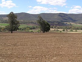
86:Upper Freestone landscape, 2007
522:Upper Freestone cemetery, 2007
1:
456:Murray-Darling drainage basin
51:GPX (secondary coordinates)
1477:
186:1.773/km (4.59/sq mi)
1433:
880:
872:Towns and localities in
727:(Version 1.01 ed.),
354:
298:
294:
91:
79:
46:GPX (primary coordinates)
21:Map all coordinates using
1461:Localities in Queensland
558:Upper Freestone cemetery
29:Download coordinates as:
816:"Upper Freestone (SSC)"
633:"Upper Freestone (SAL)"
820:2016 Census QuickStats
667:Queensland Place Names
637:2021 Census QuickStats
523:
471:
1456:Southern Downs Region
874:Southern Downs Region
756:Queensland Government
671:Queensland Government
521:
469:
454:). It is part of the
373:Southern Downs Region
265:Southern Downs Region
41:GPX (all coordinates)
547:28.1360°S 152.1984°E
495:28.1369°S 152.1919°E
440:Great Dividing Range
411:28.0903°S 152.2103°E
379:, Australia. In the
147:28.1233°S 152.2205°E
703:State of Queensland
542: /
490: /
406: /
284:Federal division(s)
272:State electorate(s)
142: /
699:"Queensland Globe"
606:to the south-west.
552:-28.1360; 152.1984
524:
500:-28.1369; 152.1919
472:
416:-28.0903; 152.2103
152:-28.1233; 152.2205
1443:
1442:
1240:Rosenthal Heights
738:978-1-921171-26-0
362:
361:
358:
357:
1468:
866:
859:
852:
843:
836:
835:
830:
828:
826:
814:(27 June 2017).
808:
802:
801:
799:
797:
778:
772:
771:
769:
767:
748:
742:
741:
720:
714:
713:
711:
709:
695:
682:
681:
679:
677:
659:
653:
652:
647:
645:
643:
631:(28 June 2022).
625:
566:
565:
563:
562:
561:
559:
554:
553:
548:
543:
540:
539:
538:
535:
514:
513:
511:
510:
509:
507:
502:
501:
496:
491:
488:
487:
486:
483:
430:
429:
427:
426:
425:
423:
418:
417:
412:
407:
404:
403:
402:
399:
296:
166:
165:
163:
162:
161:
159:
154:
153:
148:
143:
140:
139:
138:
135:
107:
106:
100:
84:
75:
69:
64:
1476:
1475:
1471:
1470:
1469:
1467:
1466:
1465:
1446:
1445:
1444:
1439:
1429:
1380:Upper Wheatvale
1370:Upper Freestone
876:
870:
840:
839:
824:
822:
810:
809:
805:
795:
793:
780:
779:
775:
765:
763:
750:
749:
745:
739:
722:
721:
717:
707:
705:
697:
696:
685:
675:
673:
661:
660:
656:
641:
639:
627:
626:
617:
612:
592:
573:
557:
555:
551:
549:
545:
544:
541:
536:
533:
531:
529:
528:
505:
503:
499:
497:
493:
492:
489:
484:
481:
479:
477:
476:
464:
421:
419:
415:
413:
409:
408:
405:
400:
397:
395:
393:
392:
389:
365:Upper Freestone
328:Upper Freestone
183: • Density
157:
155:
151:
149:
145:
144:
141:
136:
133:
131:
129:
128:
118:
117:
116:
115:
114:
113:
112:
111:Upper Freestone
108:
87:
71:
70:
68:Upper Freestone
67:
62:
59:
58:
57:
56:
55:
12:
11:
5:
1474:
1472:
1464:
1463:
1458:
1448:
1447:
1441:
1440:
1435:Main Article:
1434:
1431:
1430:
1428:
1427:
1422:
1417:
1412:
1407:
1402:
1397:
1392:
1387:
1382:
1377:
1372:
1367:
1362:
1357:
1352:
1347:
1342:
1337:
1332:
1327:
1322:
1317:
1312:
1307:
1302:
1297:
1292:
1287:
1282:
1277:
1272:
1267:
1262:
1257:
1252:
1247:
1242:
1237:
1232:
1227:
1222:
1217:
1212:
1207:
1202:
1197:
1192:
1187:
1182:
1180:Murrays Bridge
1177:
1172:
1167:
1162:
1160:Mount Marshall
1157:
1155:Mount Colliery
1152:
1147:
1142:
1137:
1132:
1127:
1122:
1117:
1112:
1107:
1102:
1097:
1092:
1087:
1082:
1077:
1072:
1067:
1062:
1057:
1052:
1047:
1042:
1037:
1032:
1027:
1022:
1017:
1015:Forest Springs
1012:
1007:
1002:
997:
992:
987:
982:
977:
972:
967:
962:
957:
952:
947:
942:
937:
932:
927:
922:
917:
912:
907:
902:
897:
892:
887:
881:
878:
877:
871:
869:
868:
861:
854:
846:
838:
837:
803:
773:
743:
737:
715:
683:
654:
614:
613:
611:
608:
591:
588:
572:
569:
463:
460:
388:
385:
360:
359:
356:
355:
352:
351:
346:
341:
335:
334:
329:
326:
320:
319:
314:
309:
303:
302:
292:
291:
286:
280:
279:
277:Southern Downs
274:
268:
267:
262:
256:
255:
254:
253:
247:
241:
235:
227:
223:
222:
212:
206:
205:
202:
198:
197:
194:
188:
187:
184:
180:
179:
172:
168:
167:
126:
120:
119:
110:
109:
102:
101:
95:
94:
93:
92:
89:
88:
85:
77:
76:
60:
54:
53:
48:
43:
38:
32:
26:
19:
18:
17:
13:
10:
9:
6:
4:
3:
2:
1473:
1462:
1459:
1457:
1454:
1453:
1451:
1438:
1432:
1426:
1423:
1421:
1418:
1416:
1413:
1411:
1408:
1406:
1403:
1401:
1398:
1396:
1393:
1391:
1388:
1386:
1385:Victoria Hill
1383:
1381:
1378:
1376:
1373:
1371:
1368:
1366:
1363:
1361:
1358:
1356:
1353:
1351:
1348:
1346:
1343:
1341:
1340:The Hermitage
1338:
1336:
1333:
1331:
1328:
1326:
1323:
1321:
1318:
1316:
1313:
1311:
1308:
1306:
1303:
1301:
1298:
1296:
1293:
1291:
1288:
1286:
1283:
1281:
1278:
1276:
1273:
1271:
1268:
1266:
1263:
1261:
1258:
1256:
1253:
1251:
1248:
1246:
1243:
1241:
1238:
1236:
1233:
1231:
1230:Rodgers Creek
1228:
1226:
1223:
1221:
1218:
1216:
1213:
1211:
1208:
1206:
1205:Passchendaele
1203:
1201:
1198:
1196:
1193:
1191:
1190:Nundubbermere
1188:
1186:
1183:
1181:
1178:
1176:
1173:
1171:
1168:
1166:
1163:
1161:
1158:
1156:
1153:
1151:
1148:
1146:
1143:
1141:
1138:
1136:
1133:
1131:
1128:
1126:
1123:
1121:
1118:
1116:
1113:
1111:
1108:
1106:
1103:
1101:
1098:
1096:
1093:
1091:
1088:
1086:
1083:
1081:
1078:
1076:
1073:
1071:
1068:
1066:
1063:
1061:
1058:
1056:
1053:
1051:
1048:
1046:
1043:
1041:
1038:
1036:
1033:
1031:
1028:
1026:
1023:
1021:
1018:
1016:
1013:
1011:
1008:
1006:
1003:
1001:
998:
996:
993:
991:
988:
986:
983:
981:
978:
976:
973:
971:
968:
966:
963:
961:
958:
956:
953:
951:
948:
946:
943:
941:
938:
936:
933:
931:
928:
926:
923:
921:
920:Bony Mountain
918:
916:
913:
911:
908:
906:
903:
901:
898:
896:
893:
891:
888:
886:
883:
882:
879:
875:
867:
862:
860:
855:
853:
848:
847:
844:
834:
821:
817:
813:
807:
804:
791:
787:
783:
777:
774:
761:
757:
753:
747:
744:
740:
734:
730:
726:
719:
716:
704:
700:
694:
692:
690:
688:
684:
672:
668:
664:
658:
655:
651:
638:
634:
630:
624:
622:
620:
616:
609:
607:
605:
601:
597:
589:
587:
585:
580:
578:
570:
568:
564:
520:
516:
512:
475:School Road (
468:
461:
459:
457:
453:
449:
445:
441:
436:
434:
428:
386:
384:
382:
378:
374:
370:
366:
353:
350:
347:
345:
342:
340:
337:
333:
330:
327:
325:
322:
318:
315:
313:
310:
308:
305:
301:
293:
290:
287:
285:
281:
278:
275:
273:
269:
266:
263:
261:
257:
252:
248:
246:
242:
240:
236:
234:
230:
229:
228:
224:
220:
216:
213:
211:
207:
203:
199:
195:
193:
189:
185:
181:
177:
173:
169:
164:
127:
125:
121:
99:
90:
83:
78:
74:
65:
52:
49:
47:
44:
42:
39:
37:
34:
33:
31:
30:
25:
24:OpenStreetMap
22:
16:
1375:Upper Pilton
1369:
1320:Thanes Creek
1265:Spring Creek
1185:North Branch
985:Elbow Valley
940:Cherry Gully
935:Cannon Creek
823:. Retrieved
819:
806:
794:. Retrieved
785:
776:
764:. Retrieved
746:
724:
718:
706:. Retrieved
674:. Retrieved
666:
657:
640:. Retrieved
636:
593:
581:
574:
571:Demographics
525:
473:
437:
390:
364:
363:
299:
28:
27:
20:
15:
1390:Wallangarra
1215:Pikes Creek
1175:Mount Tully
1170:Mount Tabor
1165:Mount Sturt
1150:Morgan Park
1115:Loch Lomond
980:Diamondvale
945:Clintonvale
930:Canningvale
900:Applethorpe
796:9 September
766:9 September
708:9 September
642:28 February
584:2021 census
577:2016 census
550: /
537:152°11′54″E
498: /
485:152°11′31″E
414: /
401:152°12′37″E
381:2021 census
367:is a rural
339:Mount Sturt
192:Postcode(s)
176:2021 census
150: /
137:152°13′14″E
124:Coordinates
1450:Categories
1405:Willowvale
1345:The Summit
1310:Tannymorel
1295:Swan Creek
1280:Storm King
1275:Stanthorpe
1270:Springdale
1250:Silverwood
1195:Old Talgai
1105:Leslie Dam
1065:Greenlands
1055:Goldfields
1045:Glengallan
1040:Glen Niven
1035:Glen Aplin
990:Ellinthorp
955:Cunningham
950:Cottonvale
925:Broadwater
905:Ballandean
825:20 October
782:"TOWNSHIP"
676:27 January
610:References
556: (
534:28°08′10″S
504: (
482:28°08′13″S
420: (
398:28°05′25″S
377:Queensland
171:Population
156: (
134:28°07′24″S
73:Queensland
1400:Wheatvale
1360:Toolburra
1355:Thulimbah
1350:Thorndale
1325:The Falls
1285:Sugarloaf
1255:Sladevale
1245:Severnlea
1090:Killarney
1060:Goomburra
1030:Gladfield
1025:Girraween
1020:Freestone
1010:Fleurbaix
752:"Warwick"
596:Freestone
590:Education
452:Freestone
433:Gladfield
387:Geography
324:Freestone
312:Gladfield
307:Freestone
239:Toowoomba
219:UTC+10:00
210:Time zone
174:75 (
1335:The Head
1330:The Glen
1300:Swanfels
1235:Rosehill
1220:Pozieres
1210:Pikedale
1200:Palgrave
1145:Montrose
1140:Mingoola
1135:Messines
1125:Maryvale
1070:Greymare
1050:Glenlyon
1005:Fletcher
995:Emu Vale
970:Danderoo
960:Dalcouth
790:Archived
760:Archived
758:. 1937.
448:Swanfels
444:Maryvale
369:locality
349:Swanfels
344:Swanfels
332:Swanfels
317:Maryvale
251:Brisbane
226:Location
1420:Wyberba
1410:Wiyarra
1395:Warwick
1365:Tregony
1290:Sundown
1225:Pratten
1110:Leyburn
1095:Kyoomba
1080:Junabee
975:Deuchar
965:Dalveen
910:Bapaume
754:(Map).
604:Warwick
582:In the
575:In the
462:History
371:in the
289:Maranoa
245:Ipswich
233:Warwick
1425:Yangan
1415:Womina
1305:Talgai
1130:Massie
1100:Leslie
1085:Karara
1075:Hendon
895:Amiens
890:Allora
735:
600:Yangan
260:LGA(s)
1315:Thane
1260:Somme
1000:Eukey
915:Berat
885:Allan
1120:Lyra
827:2018
798:2020
768:2020
733:ISBN
710:2020
678:2020
644:2023
446:and
215:AEST
201:Area
196:4370
567:).
515:).
36:KML
1452::
818:.
788:.
784:.
731:,
701:.
686:^
669:.
665:.
635:.
618:^
458:.
435:.
375:,
865:e
858:t
851:v
829:.
800:.
770:.
712:.
680:.
646:.
560:)
508:)
424:)
221:)
217:(
178:)
160:)
Text is available under the Creative Commons Attribution-ShareAlike License. Additional terms may apply.