61:
33:
501:
511:
68:
434:
for inclusion as a unit of the
National Park Service. It has not yet attained this status, partly due to disagreements in funding between federal and state agencies and because much of the land and the riverbottom itself are privately owned (13,500 acres of desired 14,300 acres as cited in the 1971
472:
In April 2007, the Iowa
Natural Heritage Foundation announced the purchase of 1,224 acres (5 km) of additional land; currently off limits to the public, stabilization and restoration work will be done to the riverbank, with removal of non-native vegetation and replanting with more appropriate
45:
767:
757:
480:
to the south. The Upper Iowa was also called the "Oneota River", and the large number of Late
Prehistoric sites along its bluffs caused the early archaeologist
782:
777:
422:
Because of its intrinsic qualities and minimal development, the Upper Iowa River was the only river in Iowa previously considered for designation as a
762:
431:
772:
727:
544:
60:
640:
614:
685:
446:
country. Many put their canoes in at
Kendallville or nearby down river, but some paddlers prefer to start at Lime Springs by the
218:
423:
691:
752:
575:
539:
163:
596:
342:
128:
430:
recommended the state of Iowa designate the river as a state scenic river, and that the state then apply to the
346:
453:
A number of wildlife refuges and preserves dot the river's basin. Bird sightings on the river usually include
563:
306:
787:
747:
373:
365:
338:
132:
120:
697:
369:
357:
116:
427:
397:
415:. Unlike areas to the south and west, the area was not planed down by glaciation or covered in glacial
476:
The Upper Iowa was sometimes historically called the "Iowa River", creating confusion with the larger
32:
412:
534:
393:
361:
124:
721:
319:
204:
419:, resulting in present-day topography featuring steep-walled canyons and high-relief bluffs.
481:
458:
285:
600:
377:
666:
528:
462:
408:
349:
741:
401:
385:
327:
92:
592:
U.S. Geological Survey. National
Hydrography Dataset high-resolution flowline data.
715:
466:
389:
37:
Mouth of the Upper Iowa at floodstage, January 18, 2001, looking approximately west
500:
447:
199:
510:
44:
477:
454:
233:
220:
178:
165:
564:
U.S. Geological Survey
Geographic Names Information System: Upper Iowa River
334:
307:
U.S. Geological Survey
Geographic Names Information System: Upper Iowa River
106:
703:
593:
416:
323:
485:
709:
531:, a 470-million-year-old meteor crater below the Upper Iowa River.
439:
443:
404:. Its watershed comprises nearly 641,000 acres (2,590 km).
381:
353:
102:
411:
of Iowa, a region that was ice-free during the last
407:The Upper Iowa and its tributaries are part of the
291:
279:
271:
259:
249:
210:
198:
155:
147:
138:
112:
98:
88:
83:
21:
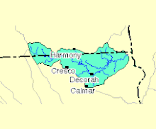
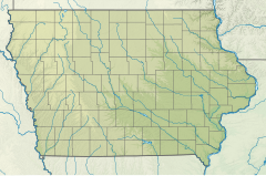
318:is a 156-mile-long (251 km) tributary of the
716:Lime Springs to French Creek Bridge *pdf format
380:. Along its course, it passes through the Iowa
8:
641:Upper Iowa River Wild And Scenic River Study
615:Upper Iowa River Wild And Scenic River Study
43:
728:Acquisition of 1224 acres (from Waukon,
509:
499:
432:United States Department of the Interior
67:
639:National Park Service (February 1971).
613:National Park Service (February 1971).
556:
49:Catchment of the Upper Iowa River (EPA)
18:
442:, taking paddlers through the scenic
7:
768:Rivers of Fillmore County, Minnesota
758:Tributaries of the Mississippi River
545:List of longest streams of Minnesota
514:Upper Iowa River looking down stream
333:Its headwaters rise in southeastern
710:Upper Iowa River Watershed Project
356:. It then flows through the Iowa
14:
783:Rivers of Winneshiek County, Iowa
778:Rivers of Mower County, Minnesota
504:Upper Iowa River looking upstream
16:River in Minnesota, United States
763:Rivers of Allamakee County, Iowa
704:Iowa Natural Heritage Foundation
426:. A 1971 study conducted by the
66:
59:
31:
686:Statistics on watershed (*.pdf)
438:The river is a destination for
424:National Wild and Scenic River
212: • coordinates
157: • coordinates
1:
773:Rivers of Howard County, Iowa
576:"Upper Iowa River Water Data"
139:Physical characteristics
75:Mouth of the Upper Iowa River
251: • elevation
671:. University of Iowa Press.
540:List of rivers of Minnesota
281: • location
804:
668:Iowa's Archaeological Past
293: • average
129:Fillmore County, Minnesota
724:(retrieved 31 March 2007)
718:(retrieved 31 March 2007)
712:(retrieved 31 March 2007)
706:(retrieved 21 March 2007)
700:(retrieved 31 March 2007)
694:(retrieved 31 March 2007)
305:
301:
267:
263:156 mi (251 km)
194:
143:
54:
42:
30:
734:(retrieved 5 April 2007)
688:(retrieved 5 April 2007)
255:620 ft (190 m)
603:, accessed May 13, 2011
374:Upper Mississippi River
372:, and finally into the
352:) near the border with
133:Mower County, Minnesota
121:Winneshiek County, Iowa
665:Alex, Lynn M. (2000).
515:
505:
117:Allamakee County, Iowa
646:(Report). p. 107
513:
503:
450:or at Florenceville.
428:National Park Service
620:(Report). p. 13
753:Rivers of Minnesota
535:List of Iowa rivers
297:696 cu/ft. per sec.
230: /
175: /
125:Howard County, Iowa
692:Water level (NOAA)
599:2012-03-29 at the
516:
506:
520:
519:
459:great blue herons
320:Mississippi River
312:
311:
234:43.466°N 91.234°W
205:Mississippi River
179:43.621°N 92.623°W
795:
673:
672:
662:
656:
655:
653:
651:
645:
636:
630:
629:
627:
625:
619:
610:
604:
594:The National Map
590:
584:
583:
572:
566:
561:
496:
495:
482:Charles R. Keyes
400:, Bluffton, and
316:Upper Iowa River
294:
286:Dorchester, Iowa
282:
245:
244:
242:
241:
240:
235:
231:
228:
227:
226:
223:
190:
189:
187:
186:
185:
180:
176:
173:
172:
171:
168:
158:
70:
69:
63:
47:
35:
22:Upper Iowa River
19:
803:
802:
798:
797:
796:
794:
793:
792:
738:
737:
682:
677:
676:
664:
663:
659:
649:
647:
643:
638:
637:
633:
623:
621:
617:
612:
611:
607:
601:Wayback Machine
591:
587:
574:
573:
569:
562:
558:
553:
525:
494:
488:for the river.
463:turkey vultures
378:New Albin, Iowa
292:
280:
252:
239:43.466; -91.234
238:
236:
232:
229:
224:
221:
219:
217:
216:
213:
184:43.621; -92.623
183:
181:
177:
174:
169:
166:
164:
162:
161:
156:
79:
78:
77:
76:
73:
72:
71:
50:
38:
26:
23:
17:
12:
11:
5:
801:
799:
791:
790:
788:Driftless Area
785:
780:
775:
770:
765:
760:
755:
750:
748:Rivers of Iowa
740:
739:
736:
735:
725:
719:
713:
707:
701:
695:
689:
681:
680:External links
678:
675:
674:
657:
631:
605:
585:
567:
555:
554:
552:
549:
548:
547:
542:
537:
532:
529:Decorah crater
524:
521:
518:
517:
507:
493:
490:
486:Oneota Culture
409:Driftless Area
310:
309:
303:
302:
299:
298:
295:
289:
288:
283:
277:
276:
273:
269:
268:
265:
264:
261:
257:
256:
253:
250:
247:
246:
214:
211:
208:
207:
202:
196:
195:
192:
191:
159:
153:
152:
149:
145:
144:
141:
140:
136:
135:
114:
110:
109:
100:
96:
95:
90:
86:
85:
81:
80:
74:
65:
64:
58:
57:
56:
55:
52:
51:
48:
40:
39:
36:
28:
27:
24:
15:
13:
10:
9:
6:
4:
3:
2:
800:
789:
786:
784:
781:
779:
776:
774:
771:
769:
766:
764:
761:
759:
756:
754:
751:
749:
746:
745:
743:
733:
731:
726:
723:
722:Kayaking site
720:
717:
714:
711:
708:
705:
702:
699:
698:Watershed map
696:
693:
690:
687:
684:
683:
679:
670:
669:
661:
658:
642:
635:
632:
616:
609:
606:
602:
598:
595:
589:
586:
581:
577:
571:
568:
565:
560:
557:
550:
546:
543:
541:
538:
536:
533:
530:
527:
526:
522:
512:
508:
502:
498:
497:
491:
489:
487:
483:
479:
474:
470:
468:
467:barn swallows
464:
460:
456:
451:
449:
445:
441:
436:
433:
429:
425:
420:
418:
414:
410:
405:
403:
399:
395:
394:Florenceville
391:
387:
383:
379:
375:
371:
367:
363:
359:
355:
351:
348:
344:
340:
336:
331:
329:
328:United States
325:
322:in the upper
321:
317:
308:
304:
300:
296:
290:
287:
284:
278:
274:
270:
266:
262:
258:
254:
248:
243:
215:
209:
206:
203:
201:
197:
193:
188:
160:
154:
150:
146:
142:
137:
134:
130:
126:
122:
118:
115:
111:
108:
104:
101:
97:
94:
93:United States
91:
87:
82:
62:
53:
46:
41:
34:
29:
20:
729:
667:
660:
648:. Retrieved
634:
622:. Retrieved
608:
588:
579:
570:
559:
484:to name the
475:
471:
452:
437:
421:
406:
398:Kendallville
390:Lime Springs
339:Mower County
332:
315:
313:
25:Oneota River
455:bald eagles
448:Lidtke Mill
237: /
182: /
742:Categories
551:References
478:Iowa River
366:Winneshiek
225:91°14′02″W
222:43°27′58″N
170:92°37′23″W
167:43°37′16″N
650:1 January
624:1 January
473:species.
370:Allamakee
350:townships
335:Minnesota
272:Discharge
107:Minnesota
730:Standard
597:Archived
523:See also
440:canoeing
435:study).
358:counties
113:District
84:Location
492:Gallery
413:ice age
402:Decorah
386:Chester
326:of the
324:Midwest
89:Country
465:, and
382:cities
368:, and
362:Howard
343:Le Roy
275:
260:Length
151:
148:Source
644:(PDF)
618:(PDF)
444:bluff
417:drift
376:near
337:, in
200:Mouth
99:State
652:2024
626:2024
580:USGS
354:Iowa
347:Lodi
345:and
314:The
103:Iowa
396:,
384:of
360:of
744::
578:.
469:.
461:,
457:,
392:,
388:,
364:,
330:.
131:,
127:,
123:,
119:,
105:,
732:)
654:.
628:.
582:.
341:(
Text is available under the Creative Commons Attribution-ShareAlike License. Additional terms may apply.