42:
386:(CDFG). Grass Lake has been designated a U.S. Forest Service Research Natural Area. The headwaters are in Desolation Wilderness and in roadless areas managed for quasi-wilderness uses by the U.S. Forest Service. Both areas receive heavy recreational use. The reach of the Upper Truckee above Christmas Valley is under study for inclusion in the federal Wild and Scenic Rivers system. Threatened native
381:
Woody vegetation in the Upper
Truckee River watershed is primarily coniferous forest with lodgepole pine, ponderosa pine, Jeffrey pine, white fir, red fir, western white pine, mountain hemlock, and sugar pine. Alders, aspen, and willows are common along the stream zone. Major wetlands include Grass
372:
Historically, Trout Creek was tributary to Upper
Truckee River in the Truckee Marsh area near the lake (fig. 2). But with development of the Tahoe Keys, the Upper Truckee River was channeled to the lake and currently the streamflow of the two tributaries combine only during high runoff.
409:
subdivision. Further hydrologic modification occurred (reaches of the river were channelized) for construction of the South Lake Tahoe airport. Spills of treated wastewater from the South Tahoe Public
Utility District's export facilities in this watershed are an ongoing concern.
357:
This watershed is the largest in the Lake Tahoe Basin and occupies 56.5 square miles (146 km), which is 18 percent of the total land area tributary to Lake Tahoe (314 square miles (810 km)). Tributaries include Angora, Echo, Grass Lake, and Big Meadow Creeks, and
416:
California State Parks acquired two properties to protect wet meadows and floodplain habitat along the Upper
Truckee River in the mid 1980s: Washoe Meadows State Park (WMSP) and Lake Valley State Recreation Area (LVSRA).
382:
Lake, Osgood Swamp, Truckee Marsh, Benwood Meadow, and Big Meadow. Two large sphagnum bogs, Grass Lake and Osgood Swamp are located in the watershed and both are considered to be
Significant Natural Areas by the
701:
345:
At the very top of the Upper
Truckee River watershed, Grass Lake and Grass Lake Creek were named by civil engineer and land surveyor, George H. Goddard, who in 1859 crossed
721:
349:
from Hope Valley in the West Fork Carson River watershed over the pass and found "a swampy valley...with a pond filled with rank grass that (we) called Grass Lake...".
696:
512:
651:
711:
383:
436:
362:, Round, and Dardanelles Lakes. Major lakes include and smaller lakes include Dardanelles, Round, Showers, Elbert, Tamarack, Ralston, and
599:
413:
The straight boulder-lined man-made channel by the airport was converted back to a more natural, meandering course as of
November, 2011.
503:
233:
716:
470:
460:
508:
152:
555:
334:
99:
326:
431:
387:
304:
498:
682:
Upper
Truckee River Restoration and Golf Course Reconfiguration Project, California State Parks (CSP) Reach
406:
359:
625:
337:. The river flows northeasterly and is 23 miles (37 km) long. It is Lake Tahoe's largest tributary.
394:) have been reintroduced into the river in the Meiss Meadows area, and the endangered shorezone plant
395:
130:
706:
95:
466:
215:
577:
600:
Lake Tahoe Basin
Watershed Management Initiative Section 2.2 Upper Truckee River Watershed
60:
56:
681:
690:
426:
322:
134:
118:
75:
17:
676:
363:
41:
346:
198:
330:
219:
203:
138:
85:
248:
235:
167:
154:
462:
Tahoe Place Names: The Origin and
History of Names in the Lake Tahoe Basin
16:
This article is about the Upper Truckee River. For the Truckee River, see
652:"Tahoe's largest wetland restoration wraps up construction after 3 years"
529:
369:
The stretch between Meyers and South Lake Tahoe is known as Lake Valley.
318:
605:(Report). Lahontan Regional Water Quality Review Board. January 2005
402:) is found near the mouth of the river on the shores of Lake Tahoe.
530:"National Hydrography Dataset high-resolution flowline data"
561:. UC Davis Tahoe Environmental Research Center. p. 17.
405:
Much of the vast Truckee Marsh was filled to create the
34:
Lake Stream, Lake Valley Creek, Little Truckee River
297:
287:
279:
274:
264:
225:
209:
197:
183:
144:
124:
114:
105:
91:
81:
71:
66:
51:
30:
321:that flows northward from the western slope of
654:(Press release). California Tahoe Conservancy
8:
702:Rivers of the Sierra Nevada (United States)
722:Rivers of the Sierra Nevada in California
454:
452:
513:United States Department of the Interior
448:
697:Rivers of El Dorado County, California
572:
570:
568:
556:"Tahoe: State of the Lake Report 2016"
493:
491:
489:
465:. Great West Books. pp. 144–145.
384:California Department of Fish and Game
27:
524:
522:
7:
437:Dardanelles and Freel Roadless Areas
504:Geographic Names Information System
677:Friends of the Upper Truckee River
25:River in California, United States
14:
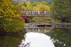
46:Upper Truckee River, October 2010
662:– via Tahoe Daily Tribune.
40:
624:Dylan Silver (April 28, 2012).
509:United States Geological Survey
227: • coordinates
146: • coordinates
1:
712:Rivers of Northern California
650:Tribune (November 14, 2022).
106:Physical characteristics
392:Oncorhynchus clarki henshawi
335:South Lake Tahoe, California
270:6,224 ft (1,897 m)
266: • elevation
189:9,480 ft (2,890 m)
185: • elevation
100:South Lake Tahoe, California
211: • location
126: • location
738:
15:
717:Rivers of the Great Basin
333:via the Truckee Marsh in
327:Alpine County, California
193:
110:
39:
536:. U.S. Geological Survey
459:Barbara Lekisch (1988).
388:Lahontan cutthroat trout
305:Trout Creek (Lake Tahoe)
299: • right
293:Echo Creek, Angora Creek
377:Ecology and restoration
289: • left
626:"Riffles by the River"
396:Lake Tahoe yellowcress
249:38.94222°N 119.99611°W
168:38.71833°N 119.98917°W
499:"Upper Truckee River"
400:Rorippa subumbellata
360:Upper and Lower Echo
254:38.94222; -119.99611
173:38.71833; -119.98917
630:Tahoe Daily Tribune
315:Upper Truckee River
275:Basin features
245: /
164: /
31:Upper Truckee River
303:Grass Lake Creek,
96:Meyers, California
311:
310:
729:
664:
663:
661:
659:
647:
641:
640:
638:
636:
621:
615:
614:
612:
610:
604:
596:
590:
589:
587:
585:
574:
563:
562:
560:
552:
546:
545:
543:
541:
534:The National Map
526:
517:
516:
495:
484:
483:
481:
479:
456:
300:
290:
260:
259:
257:
256:
255:
250:
246:
243:
242:
241:
238:
216:El Dorado County
186:
179:
178:
176:
175:
174:
169:
165:
162:
161:
160:
157:
147:
127:
55:Named after the
44:
28:
737:
736:
732:
731:
730:
728:
727:
726:
687:
686:
673:
668:
667:
657:
655:
649:
648:
644:
634:
632:
623:
622:
618:
608:
606:
602:
598:
597:
593:
583:
581:
576:
575:
566:
558:
554:
553:
549:
539:
537:
528:
527:
520:
497:
496:
487:
477:
475:
473:
458:
457:
450:
445:
423:
379:
355:
343:
298:
288:
267:
253:
251:
247:
244:
239:
236:
234:
232:
231:
228:
212:
184:
172:
170:
166:
163:
158:
155:
153:
151:
150:
145:
125:
47:
35:
32:
26:
21:
12:
11:
5:
735:
733:
725:
724:
719:
714:
709:
704:
699:
689:
688:
685:
684:
679:
672:
671:External links
669:
666:
665:
642:
616:
591:
564:
547:
518:
485:
471:
447:
446:
444:
441:
440:
439:
434:
429:
422:
419:
378:
375:
354:
351:
342:
339:
309:
308:
307:(historically)
301:
295:
294:
291:
285:
284:
281:
277:
276:
272:
271:
268:
265:
262:
261:
229:
226:
223:
222:
213:
210:
207:
206:
201:
195:
194:
191:
190:
187:
181:
180:
148:
142:
141:
128:
122:
121:
116:
112:
111:
108:
107:
103:
102:
93:
89:
88:
83:
79:
78:
73:
69:
68:
64:
63:
53:
49:
48:
45:
37:
36:
33:
24:
13:
10:
9:
6:
4:
3:
2:
734:
723:
720:
718:
715:
713:
710:
708:
705:
703:
700:
698:
695:
694:
692:
683:
680:
678:
675:
674:
670:
653:
646:
643:
631:
627:
620:
617:
601:
595:
592:
579:
573:
571:
569:
565:
557:
551:
548:
535:
531:
525:
523:
519:
514:
510:
506:
505:
500:
494:
492:
490:
486:
474:
472:9780944220016
468:
464:
463:
455:
453:
449:
442:
438:
435:
433:
430:
428:
427:Truckee River
425:
424:
420:
418:
414:
411:
408:
403:
401:
397:
393:
389:
385:
376:
374:
370:
367:
365:
361:
352:
350:
348:
340:
338:
336:
332:
328:
324:
323:Red Lake Peak
320:
316:
306:
302:
296:
292:
286:
282:
278:
273:
269:
263:
258:
230:
224:
221:
217:
214:
208:
205:
202:
200:
196:
192:
188:
182:
177:
149:
143:
140:
136:
135:Alpine County
132:
131:Sierra Nevada
129:
123:
120:
119:Red Lake Peak
117:
113:
109:
104:
101:
97:
94:
90:
87:
84:
80:
77:
76:United States
74:
70:
65:
62:
58:
54:
50:
43:
38:
29:
23:
19:
18:Truckee River
658:November 14,
656:. Retrieved
645:
635:December 29,
633:. Retrieved
629:
619:
609:December 29,
607:. Retrieved
594:
584:December 28,
582:. Retrieved
550:
540:December 28,
538:. Retrieved
533:
502:
478:December 28,
476:. Retrieved
461:
415:
412:
404:
399:
391:
380:
371:
368:
364:Angora Lakes
356:
344:
314:
312:
22:
432:Trout Creek
347:Luther Pass
280:Tributaries
252: /
240:119°59′46″W
171: /
159:119°59′21″W
707:Lake Tahoe
691:Categories
443:References
407:Tahoe Keys
331:Lake Tahoe
237:38°56′32″N
220:California
204:Lake Tahoe
156:38°43′06″N
139:California
86:California
353:Watershed
52:Etymology
580:(Report)
421:See also
67:Location
341:History
72:Country
61:Truckee
469:
319:stream
283:
115:Source
92:Cities
59:chief
57:Paiute
603:(PDF)
559:(PDF)
317:is a
199:Mouth
82:State
660:2022
637:2012
611:2012
586:2012
578:WRIR
542:2012
480:2012
467:ISBN
313:The
329:to
325:in
693::
628:.
567:^
532:.
521:^
511:,
507:.
501:.
488:^
451:^
366:.
218:,
137:,
133:,
98:,
639:.
613:.
588:.
544:.
515:.
482:.
398:(
390:(
20:.
Text is available under the Creative Commons Attribution-ShareAlike License. Additional terms may apply.