44:
60:
574:
128:
67:
269:
255:
411:) the majority of the village became part of Poland, and its original name was restored. On June 22, 1945, at two hours notice, all inhabitants were forced to leave their homes, allowed a maximal luggage of 10 kg. New Polish people later arrived in the village. A few remaining houses left of the Oder became part of
699:
363:
in the village. The area formed part of Poland since the establishment of the state in the 10th century. The territory was administratively located within the Lubusz
694:
375:. The current settlement was formed in the early 13th century. It was first mentioned in documents in 1350. After Polish rule, it was ruled by the
704:
540:
689:
709:
88:
658:
588:
638:
608:
598:
360:
653:
648:
603:
613:
59:
618:
230:
43:
623:
533:
380:
352:
376:
238:
481:
248:
372:
526:
328:
140:
120:
457:"Central Statistical Office (GUS) – TERYT (National Register of Territorial Land Apportionment Journal)"
209:
17:
219:
356:
456:
396:
383:. Its original Slavic (Polish) name Urad remained official until 1608, when it was Germanized to
368:
305:
145:
301:
157:
387:. Despite the annexation of the territory by Brandenburg, the village was still inhabited by
348:
262:
392:
285:
281:
593:
332:
683:
549:
388:
297:
169:
436:
412:
404:
316:
633:
336:
407:, in 1945, along with the right-bank Lubusz Land (portion situated east of the
663:
628:
573:
416:
408:
324:
103:
90:
364:
200:
643:
563:
400:
320:
309:
293:
226:
205:
152:
133:
268:
254:
164:
518:
522:
371:, both established in the early 12th century by Polish ruler
319:
river, approximately 11 kilometres (7 mi) north-west of
391:
in the 17th century, and there were church services in the
511:(in German). Heimatkreis Weststernberg. p. 631.
581:
556:
261:
247:
237:
216:
199:
191:
183:
175:
163:
151:
139:
119:
27:
700:Populated places established in the 13th century
347:There are several archaeological sites from the
415:and were incorporated into the municipality of
534:
8:
331:, and 66 km (41 mi) north-west of
308:, in western Poland, close to the border of
541:
527:
519:
24:
509:Das Sternberger Land im Wandel der Zeiten
395:. From the 18th century, it was part of
327:, 64 km (40 mi) south-west of
476:
474:
472:
470:
468:
466:
428:
323:, 13 km (8 mi) south-east of
246:
236:
198:
190:
174:
118:
83:
52:
40:
507:Heinz W. Linke, Heinz Paschke (1988).
403:. After the defeat of Nazi Germany in
695:13th-century establishments in Poland
260:
215:
182:
162:
150:
138:
22:Village in Lubusz Voivodeship, Poland
7:
335:. It is located within the historic
296:in the administrative district of
14:
572:
399:, and until 1945 it was part of
280:
267:
253:
126:
65:
58:
42:
705:Archaeological sites in Poland
1:
66:
710:Prehistoric sites in Poland
726:
690:Villages in Słubice County
377:Margraviate of Brandenburg
369:Catholic Diocese of Lubusz
15:
570:
84:
53:
41:
34:
459:(in Polish). 2008-06-01.
486:Urząd Miejski w Cybince
289:
373:Bolesław III Wrymouth
218: • Summer (
239:Vehicle registration
329:Gorzów Wielkopolski
100: /
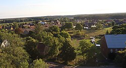
48:Aerial view of Urad
306:Lubusz Voivodeship
677:
676:
381:Bohemia (Czechia)
361:Early Middle Ages
275:
274:
263:Voivodeship roads
104:52.267°N 14.700°E
717:
576:
543:
536:
529:
520:
513:
512:
504:
498:
497:
495:
493:
478:
461:
460:
453:
447:
446:
444:
443:
433:
283:
271:
257:
223:
132:
130:
129:
115:
114:
112:
111:
110:
105:
101:
98:
97:
96:
93:
69:
68:
62:
46:
25:
725:
724:
720:
719:
718:
716:
715:
714:
680:
679:
678:
673:
577:
568:
552:
547:
517:
516:
506:
505:
501:
491:
489:
480:
479:
464:
455:
454:
450:
441:
439:
435:
434:
430:
425:
393:Polish language
345:
315:It lies on the
217:
184:First mentioned
127:
125:
108:
106:
102:
99:
94:
91:
89:
87:
86:
80:
79:
78:
77:
76:
75:
74:
70:
49:
37:
30:
23:
20:
12:
11:
5:
723:
721:
713:
712:
707:
702:
697:
692:
682:
681:
675:
674:
672:
671:
666:
661:
656:
651:
646:
641:
636:
631:
626:
621:
616:
611:
606:
601:
596:
591:
585:
583:
579:
578:
571:
569:
567:
566:
560:
558:
554:
553:
548:
546:
545:
538:
531:
523:
515:
514:
499:
462:
448:
437:"Aurith, Urad"
427:
426:
424:
421:
344:
341:
302:Słubice County
273:
272:
265:
259:
258:
251:
249:National roads
245:
244:
241:
235:
234:
224:
214:
213:
203:
197:
196:
193:
189:
188:
185:
181:
180:
177:
173:
172:
167:
161:
160:
155:
149:
148:
143:
137:
136:
123:
117:
116:
109:52.267; 14.700
82:
81:
72:
71:
64:
63:
57:
56:
55:
54:
51:
50:
47:
39:
38:
35:
32:
31:
28:
21:
13:
10:
9:
6:
4:
3:
2:
722:
711:
708:
706:
703:
701:
698:
696:
693:
691:
688:
687:
685:
670:
667:
665:
662:
660:
657:
655:
652:
650:
647:
645:
642:
640:
637:
635:
632:
630:
627:
625:
622:
620:
617:
615:
612:
610:
607:
605:
602:
600:
597:
595:
592:
590:
587:
586:
584:
580:
575:
565:
562:
561:
559:
557:Town and seat
555:
551:
550:Gmina Cybinka
544:
539:
537:
532:
530:
525:
524:
521:
510:
503:
500:
487:
483:
477:
475:
473:
471:
469:
467:
463:
458:
452:
449:
438:
432:
429:
422:
420:
418:
414:
410:
406:
402:
398:
394:
390:
386:
382:
378:
374:
370:
366:
362:
358:
354:
350:
342:
340:
338:
334:
330:
326:
322:
318:
313:
311:
307:
303:
299:
298:Gmina Cybinka
295:
291:
287:
282:
279:
270:
266:
264:
256:
252:
250:
242:
240:
232:
228:
225:
221:
211:
207:
204:
202:
194:
186:
178:
171:
168:
166:
159:
156:
154:
147:
144:
142:
135:
124:
122:
113:
85:Coordinates:
61:
45:
33:
26:
19:
668:
508:
502:
490:. Retrieved
485:
451:
440:. Retrieved
431:
413:East Germany
405:World War II
384:
346:
333:Zielona Góra
314:
277:
276:
179:13th century
634:Mielesznica
492:19 February
488:(in Polish)
337:Lubusz Land
141:Voivodeship
107: /
684:Categories
649:Rybojedzko
482:"Historia"
442:2024-09-11
423:References
417:Ziltendorf
409:Oder River
365:castellany
353:Bronze Age
192:Population
16:See also:
594:Białkówek
357:antiquity
349:Stone Age
300:, within
201:Time zone
639:Radzików
619:Koziczyn
609:Grzmiąca
604:Drzeniów
599:Bieganów
582:Villages
367:and the
664:Tawęcin
659:Szydłów
629:Maczków
624:Krzesin
589:Białków
564:Cybinka
401:Germany
397:Prussia
343:History
325:Słubice
321:Cybinka
310:Germany
294:village
292:) is a
176:Founded
170:Cybinka
158:Słubice
121:Country
95:14°42′E
92:52°16′N
36:Village
644:Rąpice
614:Kłopot
385:Aurith
290:Aurith
286:German
153:County
146:Lubusz
134:Poland
131:
654:Sądów
389:Poles
227:UTC+2
206:UTC+1
165:Gmina
669:Urad
494:2022
379:and
359:and
317:Oder
278:Urad
231:CEST
187:1350
73:Urad
29:Urad
18:Urad
339:.
243:FSL
220:DST
210:CET
195:430
686::
484:.
465:^
419:.
355:,
351:,
312:.
304:,
288::
542:e
535:t
528:v
496:.
445:.
284:(
233:)
229:(
222:)
212:)
208:(
Text is available under the Creative Commons Attribution-ShareAlike License. Additional terms may apply.