106:
583:
73:
377:
365:
353:
389:
53:
38:
113:
80:
337:
The Old St
Martinus Church was built between 1791 and 1793. The medieval tower was placed in 1841. The cemetery is artificially heightened. In 1695, a Dutch Reformed church was built in Urmond which is exceptional in Limburg.
648:
326:
The village was first mentioned in 1153 as
Ouermunte. The current name means "mouth of the Ur", however the Ur has later moved to village. Urmond developed on the higher bank of the
643:
658:
105:
624:
564:
285:
297:
141:
512:
72:
617:
277:
610:
341:
Urmond was home to 600 people in 1840. Urmond was a separate municipality until 1982, when it was merged with Stein.
376:
364:
352:
173:
653:
590:
316:
256:
388:
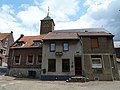
52:
266:
188:
37:
502:
582:
331:
508:
594:
418:
320:
198:
637:
312:
178:
472:
156:
143:
247:
538:
273:
252:
327:
446:
598:
125:
Location in the province of
Limburg in the Netherlands
296:
284:
263:
246:
238:
230:
225:
217:
209:
204:
194:
184:
172:
21:
501:Sabine Broekhoven, & Ronald Stenvert (2003).
649:Former municipalities of Limburg (Netherlands)
618:
8:
625:
611:
496:
494:
18:
644:Populated places in Limburg (Netherlands)
533:
531:
405:
348:
319:. It is located in the municipality of
283:
245:
224:
216:
203:
171:
136:
64:
46:
34:
413:
411:
409:
659:Limburg (Netherlands) geography stubs
565:Repertorium van Nederlandse gemeenten
295:
262:
237:
229:
208:
193:
183:
7:
579:
577:
419:"Kerncijfers wijken en buurten 2021"
563:Ad van der Meer and Onno Boonstra,
213:2.87 km (1.11 sq mi)
597:. You can help Knowledge (XXG) by
14:
330:. In 1400, it became part of the
581:
387:
375:
363:
351:
128:Show map of Limburg, Netherlands
111:
104:
78:
71:
51:
36:
453:(in Dutch). Het Waterschapshuis
451:Actueel Hoogtebestand Nederland
16:Village in Limburg, Netherlands
507:(in Dutch). Zwolle: Waanders.
473:"Urmond - (geografische naam)"
112:
79:
1:
423:Central Bureau of Statistics
242:1,200/km (3,200/sq mi)
92:Location in the Netherlands
675:
576:
447:"Postcodetool for 6129AA"
137:
65:
47:
35:
28:
221:46 m (151 ft)
95:Show map of Netherlands
593:location article is a
265: • Summer (
311:is a village in the
239: • Density
157:50.99056°N 5.77111°E
358:Apartment buildings
153: /
231: • Total
210: • Total
606:
605:
306:
305:
162:50.99056; 5.77111
666:
627:
620:
613:
585:
578:
568:
561:
555:
554:
552:
550:
535:
526:
525:
523:
521:
498:
489:
488:
486:
484:
469:
463:
462:
460:
458:
443:
437:
436:
431:
429:
415:
391:
379:
370:Former town hall
367:
355:
270:
168:
167:
165:
164:
163:
158:
154:
151:
150:
149:
146:
129:
115:
114:
108:
96:
82:
81:
75:
55:
42:Centre of Urmond
40:
19:
674:
673:
669:
668:
667:
665:
664:
663:
634:
633:
632:
631:
574:
572:
571:
562:
558:
548:
546:
537:
536:
529:
519:
517:
515:
500:
499:
492:
482:
480:
471:
470:
466:
456:
454:
445:
444:
440:
427:
425:
417:
416:
407:
402:
395:
392:
383:
380:
371:
368:
359:
356:
347:
332:Duchy of Jülich
292:
264:
161:
159:
155:
152:
147:
144:
142:
140:
139:
133:
132:
131:
130:
127:
126:
123:
122:
121:
120:
116:
99:
98:
97:
94:
93:
90:
89:
88:
87:
83:
61:
60:
59:
58:
43:
31:
24:
17:
12:
11:
5:
672:
670:
662:
661:
656:
654:Stein, Limburg
651:
646:
636:
635:
630:
629:
622:
615:
607:
604:
603:
586:
570:
569:
567:, KNAW, 2011.
556:
527:
513:
490:
477:Etymologiebank
464:
438:
404:
403:
401:
398:
397:
396:
393:
386:
384:
381:
374:
372:
369:
362:
360:
357:
350:
346:
343:
304:
303:
300:
294:
293:
290:
288:
282:
281:
271:
261:
260:
250:
244:
243:
240:
236:
235:
232:
228:
227:
223:
222:
219:
215:
214:
211:
207:
206:
202:
201:
196:
192:
191:
186:
182:
181:
176:
170:
169:
135:
134:
124:
118:
117:
110:
109:
103:
102:
101:
100:
91:
85:
84:
77:
76:
70:
69:
68:
67:
66:
63:
62:
56:
50:
49:
48:
45:
44:
41:
33:
32:
29:
26:
25:
22:
15:
13:
10:
9:
6:
4:
3:
2:
671:
660:
657:
655:
652:
650:
647:
645:
642:
641:
639:
628:
623:
621:
616:
614:
609:
608:
602:
600:
596:
592:
591:Dutch Limburg
587:
584:
580:
575:
566:
560:
557:
544:
540:
534:
532:
528:
516:
514:90 400 9623 6
510:
506:
505:
497:
495:
491:
478:
474:
468:
465:
452:
448:
442:
439:
435:
424:
420:
414:
412:
410:
406:
399:
390:
385:
378:
373:
366:
361:
354:
349:
344:
342:
339:
335:
333:
329:
324:
322:
318:
314:
310:
301:
299:
289:
287:
279:
275:
272:
268:
258:
254:
251:
249:
241:
233:
220:
212:
200:
197:
190:
187:
180:
177:
175:
166:
138:Coordinates:
107:
74:
54:
39:
27:
20:
599:expanding it
588:
573:
559:
547:. Retrieved
543:Plaatsengids
542:
518:. Retrieved
503:
481:. Retrieved
476:
467:
455:. Retrieved
450:
441:
433:
426:. Retrieved
422:
340:
336:
325:
315:province of
308:
307:
298:Dialing code
195:Municipality
434:two entries
394:Terp Church
382:Street view
286:Postal code
179:Netherlands
160: /
638:Categories
545:(in Dutch)
479:(in Dutch)
400:References
226:Population
145:50°59′26″N
248:Time zone
218:Elevation
148:5°46′16″E
549:26 April
539:"Urmond"
520:26 April
483:26 April
457:26 April
428:26 April
185:Province
345:Gallery
317:Limburg
189:Limburg
174:Country
30:Village
511:
504:Urmond
309:Urmond
119:Urmond
86:Urmond
23:Urmond
589:This
321:Stein
313:Dutch
274:UTC+2
253:UTC+1
234:3,555
199:Stein
595:stub
551:2022
522:2022
509:ISBN
485:2022
459:2022
430:2022
328:Maas
291:6129
278:CEST
205:Area
57:Flag
302:046
267:DST
257:CET
640::
541:.
530:^
493:^
475:.
449:.
432:.
421:.
408:^
334:.
323:.
626:e
619:t
612:v
601:.
553:.
524:.
487:.
461:.
280:)
276:(
269:)
259:)
255:(
Text is available under the Creative Commons Attribution-ShareAlike License. Additional terms may apply.