176:
38:
97:
1596:
58:
82:
875:
824:
1615:
568:
Geophysicists found that crust under the Eifel is thinner than most continental crust, suggesting that under the Eifel is a hot zone where magma is rising.
1640:
303:
751:
737:
868:
588:. This activity does not imply an immediate eruptive danger, but might suggest an increase in volcanic and seismic activity in the region.
1536:
294:
The entire
Volcanic Eifel covers an area of about 2,000 km (770 sq mi) and as of 2007 has a population of about 200,000.
335:, 681 m (2,230 ft), county of Vulkaneifel – not volcanic (eponymous quartzite ridge; other summits being the Scharteberg and
1208:
215:
700:
861:
1620:
1046:
167:. The Volcanic Eifel is still volcanically active today. One sign of this activity is the escaping gases in the Laacher See.
1635:
1630:
1225:
179:
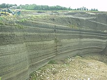
The
Wingertsbergwand gives an idea of the amount of volcanic ash ejected during the eruption of the Laacher See volcano.
503:
1625:
671:
1519:
962:
518:
491:
584:
happened at significantly higher levels than expected. It is possible that such movements originate from a rising
533:
deposited by past eruptions of the
Volcanic Eifel are lithological deposits that are radiometrically dateable via
1369:
1273:
1005:
897:
803:
779:
345:, 674.9 m (2,210 ft), county of Vulkaneifel; with a transmission mast on its south summit – Tertiary
291:
layers and maars create a diverse landscape that clearly witnesses to very recent events in geological terms.
1470:
1034:
914:
808:
784:
541:
grains. These have in turn been utilised to ascertain the ages of climatic changes such as transitions from
277:
513:
1560:
1548:
1464:
1292:
1010:
418:
1531:
1405:
1068:
444:
1524:
1452:
1201:
580:
In 2020, Professor
Kreemer noted that Eifel was the only region within an area of Europe studied where
460:
437:, 428.1 m (1,400 ft), county of Ahrweiler; near Laacher See; with an observation tower, the
175:
1357:
1249:
508:
276:
The centre of the
Volcanic Eifel is the region around Daun and Manderscheid and the areas within the
144:
46:
1393:
207:. To the east the Rhine forms its geographical boundary, with no volcanicity immediately beyond it.
682:
382:
188:
1381:
352:
1423:
1100:
1057:
534:
470:
438:
424:
231:
1512:
1488:
309:
610:"Precise single-grain 40Ar/39 Ar dating of a cold to warm climate transition in Central Europe"
575:
Map of flood lake that may happen if the Rhine is blocked by a voluminous eruption in the Eifel
364:
1507:
1352:
1136:
1076:
1063:
1041:
747:
733:
631:
448:
408:
392:
326:
283:
The landscape of the
Volcanic Eifel is dominated by recent volcanism. Volcanic craters, thick
89:
361:, 617.6 m (2,030 ft), county of Vulkaneifel; with a wooden observation tower – west
308:
The following volcanoes belong to the Eifel, sorted by height in metres (m) above sea level (
1495:
1434:
1364:
1220:
1213:
1160:
1105:
1029:
623:
614:
37:
701:"Volcano warning: 'Something is brewing under Europe' Geologists make incredible discovery"
1328:
1268:
1088:
932:
921:
884:
574:
160:
116:
62:
937:
926:
1237:
1165:
1153:
957:
902:
542:
140:
96:
1609:
1376:
1316:
1280:
1256:
1093:
581:
348:
332:
250:
219:
74:
1595:
351:, 651.7 m (2,140 ft), county of Vulkaneifel; with the castle ruins of the
1579:
1475:
1459:
1309:
1112:
1022:
909:
546:
454:
1285:
1081:
376:
655:
608:
van den
Bogaard, P.; Hall, C. M.; Schmincke, H.-U.; York, D. (30 November 1989).
1555:
1345:
1321:
1297:
1188:
1172:
1017:
585:
550:
487:
342:
322:
261:
200:
192:
164:
42:
31:
798:
774:
1572:
1567:
1543:
1261:
1232:
1117:
974:
969:
538:
414:
398:
370:
358:
336:
227:
223:
204:
853:
839:
826:
635:
319:(also: Erresberg), 699.9 m (2,300 ft), county of Vulkaneifel – west
1584:
1500:
1177:
1141:
1052:
997:
986:
434:
386:
367:, approximately 590 m (1,940 ft), county of Vulkaneifel – Tertiary
316:
50:
17:
1447:
609:
1400:
1304:
1244:
1183:
950:
257:
196:
136:
490:, the site of an eruption around 12,900 years ago that had an estimated
427:, approximately 475 m (1,560 ft), county of Vulkaneifel (near
57:
1439:
1428:
1417:
1412:
1388:
1340:
1129:
945:
269:
246:
100:
1483:
1333:
627:
530:
428:
288:
284:
265:
242:
85:
81:
561:
There is thought that future eruptions may occur in the Eifel, as:
981:
474:
464:
463:, 363.2 m (1,190 ft), county of Mayen-Koblenz (north of
447:, 427.5 m (1,400 ft), county of Mayen-Koblenz (south of
184:
174:
132:
95:
80:
56:
36:
401:
151:, and numerous other signs of volcanic activity such as volcanic
1148:
1124:
417:, 549.1 m (1,800 ft), county of Vulkaneifel; with the
325:, 691.4 m (2,270 ft), county of Vulkaneifel; with the
235:
156:
152:
148:
70:
857:
1196:
457:, 372.5 m (1,220 ft), county of Mayen-Koblenz – east
379:, 573.3 m (1,880 ft), county of Mayen-Koblenz – east
373:, 587.9 m (1,930 ft), county of Mayen-Koblenz – east
135:
Mountains in
Germany that is defined to a large extent by its
763:
411:, 554.6 m (1,820 ft), county of Vulkaneifel – west
395:, 563 m (1,850 ft), county of Mayen-Koblenz – east
744:
Vulkane der Eifel: Aufbau, Entstehung und heutige
Bedeutung
473:, 295 m (970 ft), county of Mayen-Koblenz (near
385:, 575.1 m (1,890 ft), county of Ahrweiler (near
210:
The Volcanic Eifel is divided into three natural regions:
768:
732:
Schweizerbart’sche Verlagsbuchhandlung, Stuttgart 2013.
571:
Persistent small earthquakes and underground heating.
486:
Of particular note is the volcanic caldera known as
658:
of the Federal Office of Geoscience and Resources (
191:. It is bordered in the south and southwest by the
660:Bundesanstalt für Geowissenschaften und Rohstoffe
565:Each year the Eifel rises by about a millimetre.
672:Is there still volcanic activity in the Eifel?
30:For the district named after this region, see
869:
103:on the southeastern shore of the Laacher See.
8:
139:geological history. Characteristic of this
27:German geologic formation with crater lakes
876:
862:
854:
694:
692:
690:
683:Germany: a danger of volcanic eruptions?
304:List of mountains and hills of the Eifel
195:, in the west by Luxembourg and Belgian
597:
88:layers in a quarry near Weibern in the
183:The Volcanic Eifel stretches from the
746:, Springer Spektrum, Wiesbaden 2014.
7:
603:
601:
699:Kettley, Sebastian (11 June 2020).
1616:Landscapes of Rhineland-Palatinate
25:
504:Vulkanland Eifel National Geopark
1594:
764:Homepage of Vulkaneifel district
1641:Global Geoparks Network members
405:(observation tower) – Tertiary
1:
769:German Volcanological Society
519:German Volcano Museum, Mendig
403:Volcano Information Platform
799:"West Eifel Volcanic Field"
775:"East Eifel Volcanic Field"
1657:
1520:Thuringian Slate Mountains
301:
143:are its typical explosion
29:
1592:
1496:Teutoburg Forest (Osning)
892:
125:East Eifel Volcanic Field
1006:Elbe Sandstone Mountains
898:Anterior Bavarian Forest
804:Global Volcanism Program
780:Global Volcanism Program
199:and in the north by the
809:Smithsonian Institution
785:Smithsonian Institution
742:Hans-Ulrich Schmincke:
49:in Central Europe near
1293:North Palatine Uplands
419:Hoher List Observatory
278:Mayen-Koblenz district
234:(within the parish of
180:
131:), is a region in the
120:
104:
93:
78:
54:
1621:Pleistocene volcanism
1532:Upper Palatine Forest
1406:Geiersberg (Breitsol)
975:(Prussian) Velmerstot
514:Volcano House, Strohn
256:Volcanic East Eifel (
241:Volcanic High Eifel (
214:Volcanic West Eifel (
178:
171:Geographical location
123:), also known as the
99:
84:
60:
40:
1636:Regions of the Eifel
1631:Volcanism of Germany
1561:Paschenburg Mountain
1130:Brocken (Blocksberg)
509:Volcano Museum, Daun
47:volcanic crater lake
1011:Großer Zschirnstein
836: /
730:Geologie der Eifel.
498:Geopark and museums
189:Wittlich Depression
1626:Holocene volcanism
1525:Großer Farmdenkopf
1424:Lusatian Mountains
1101:Gladenbach Uplands
1069:Sieben-Linden-Berg
549:states during the
535:argon-argon dating
445:Ettringer Bellberg
181:
105:
94:
79:
55:
1603:
1602:
1508:Thuringian Forest
1353:Rothaar Mountains
1202:Lauensteiner Kopf
1137:Hildesheim Forest
1077:Franconian Forest
1042:Fichtel Mountains
752:978-3-8274-2985-8
738:978-3-510-65279-2
622:(6249): 523–525.
409:Rockeskyller Kopf
327:Eifel Transmitter
16:(Redirected from
1648:
1598:
1435:Zittau Mountains
1365:Saalhausen Hills
1221:Kaufungen Forest
1030:Elster Mountains
878:
871:
864:
855:
851:
850:
848:
847:
846:
841:
840:50.283°N 7.000°E
837:
834:
833:
832:
829:
818:
816:
815:
794:
792:
791:
716:
715:
713:
711:
696:
685:
680:
674:
669:
663:
653:
647:
646:
644:
642:
628:10.1038/342523a0
605:
461:Mayener Bellberg
161:volcanic craters
21:
1656:
1655:
1651:
1650:
1649:
1647:
1646:
1645:
1606:
1605:
1604:
1599:
1590:
1513:Großer Beerberg
1489:Großer Feldberg
1329:Palatine Forest
1269:Lenne Mountains
1089:Franconian Jura
933:Bavarian Forest
922:Bohemian Forest
888:
885:Central Uplands
882:
844:
842:
838:
835:
830:
827:
825:
823:
822:
813:
811:
797:
789:
787:
773:
760:
728:Wilhelm Meyer:
725:
723:Further reading
720:
719:
709:
707:
698:
697:
688:
681:
677:
670:
666:
654:
650:
640:
638:
607:
606:
599:
594:
559:
557:Future activity
527:
500:
484:
389:-Engeln) – east
310:Normalhöhennull
306:
300:
173:
69:, one of three
63:Weinfelder Maar
35:
28:
23:
22:
15:
12:
11:
5:
1654:
1652:
1644:
1643:
1638:
1633:
1628:
1623:
1618:
1608:
1607:
1601:
1600:
1593:
1591:
1589:
1588:
1576:
1564:
1552:
1540:
1528:
1516:
1504:
1492:
1480:
1456:
1444:
1409:
1397:
1385:
1373:
1361:
1349:
1337:
1325:
1313:
1301:
1289:
1277:
1265:
1253:
1241:
1229:
1217:
1205:
1193:
1169:
1166:Kasseler Kuppe
1157:
1145:
1133:
1121:
1113:Goshawk Forest
1109:
1097:
1085:
1073:
1038:
1026:
1014:
1002:
993:Volcanic Eifel
978:
970:Egge Mountains
966:
958:Ebbe Mountains
954:
942:
918:
906:
893:
890:
889:
883:
881:
880:
873:
866:
858:
820:
819:
795:
771:
766:
759:
758:External links
756:
755:
754:
740:
724:
721:
718:
717:
686:
675:
664:
648:
596:
595:
593:
590:
578:
577:
572:
569:
566:
558:
555:
526:
523:
522:
521:
516:
511:
506:
499:
496:
483:
480:
479:
478:
468:
458:
452:
442:
432:
422:
412:
406:
396:
390:
380:
374:
368:
362:
356:
346:
340:
330:
320:
299:
296:
274:
273:
254:
239:
203:including the
172:
169:
141:volcanic field
109:Volcanic Eifel
45:, the largest
26:
24:
14:
13:
10:
9:
6:
4:
3:
2:
1653:
1642:
1639:
1637:
1634:
1632:
1629:
1627:
1624:
1622:
1619:
1617:
1614:
1613:
1611:
1597:
1587:
1586:
1582:
1581:
1577:
1575:
1574:
1570:
1569:
1565:
1563:
1562:
1558:
1557:
1553:
1551:
1550:
1546:
1545:
1541:
1539:
1538:
1534:
1533:
1529:
1527:
1526:
1522:
1521:
1517:
1515:
1514:
1510:
1509:
1505:
1503:
1502:
1498:
1497:
1493:
1491:
1490:
1486:
1485:
1481:
1478:
1477:
1473:
1472:
1467:
1466:
1462:
1461:
1457:
1455:
1454:
1450:
1449:
1445:
1442:
1441:
1440:Lausche (Luž)
1437:
1436:
1431:
1430:
1429:Lausche (Luž)
1426:
1425:
1420:
1419:
1418:Lausche (Luž)
1415:
1414:
1410:
1408:
1407:
1403:
1402:
1398:
1396:
1395:
1391:
1390:
1386:
1384:
1383:
1382:Großer Ölberg
1379:
1378:
1377:Siebengebirge
1374:
1372:
1371:
1367:
1366:
1362:
1360:
1359:
1355:
1354:
1350:
1348:
1347:
1343:
1342:
1338:
1336:
1335:
1331:
1330:
1326:
1324:
1323:
1319:
1318:
1317:Ore Mountains
1314:
1312:
1311:
1307:
1306:
1302:
1300:
1299:
1295:
1294:
1290:
1288:
1287:
1283:
1282:
1281:Lippe Uplands
1278:
1276:
1275:
1271:
1270:
1266:
1264:
1263:
1259:
1258:
1254:
1252:
1251:
1247:
1246:
1242:
1240:
1239:
1235:
1234:
1230:
1228:
1227:
1223:
1222:
1218:
1216:
1215:
1211:
1210:
1206:
1204:
1203:
1199:
1198:
1194:
1191:
1190:
1186:
1185:
1180:
1179:
1175:
1174:
1170:
1168:
1167:
1163:
1162:
1161:Hoher Meißner
1158:
1156:
1155:
1151:
1150:
1146:
1144:
1143:
1139:
1138:
1134:
1132:
1131:
1127:
1126:
1122:
1120:
1119:
1115:
1114:
1110:
1108:
1107:
1103:
1102:
1098:
1096:
1095:
1091:
1090:
1086:
1084:
1083:
1079:
1078:
1074:
1071:
1070:
1066:
1065:
1060:
1059:
1055:
1054:
1049:
1048:
1044:
1043:
1039:
1037:
1036:
1032:
1031:
1027:
1025:
1024:
1020:
1019:
1015:
1013:
1012:
1008:
1007:
1003:
1000:
999:
995:
994:
989:
988:
984:
983:
979:
977:
976:
972:
971:
967:
965:
964:
960:
959:
955:
953:
952:
948:
947:
943:
940:
939:
935:
934:
929:
928:
924:
923:
919:
917:
916:
912:
911:
907:
905:
904:
900:
899:
895:
894:
891:
886:
879:
874:
872:
867:
865:
860:
859:
856:
852:
849:
845:50.283; 7.000
810:
806:
805:
800:
796:
786:
782:
781:
776:
772:
770:
767:
765:
762:
761:
757:
753:
749:
745:
741:
739:
735:
731:
727:
726:
722:
706:
702:
695:
693:
691:
687:
684:
679:
676:
673:
668:
665:
661:
657:
652:
649:
637:
633:
629:
625:
621:
617:
616:
611:
604:
602:
598:
591:
589:
587:
583:
582:ground motion
576:
573:
570:
567:
564:
563:
562:
556:
554:
552:
548:
544:
540:
536:
532:
524:
520:
517:
515:
512:
510:
507:
505:
502:
501:
497:
495:
493:
489:
481:
476:
472:
469:
466:
462:
459:
456:
453:
450:
446:
443:
440:
436:
433:
430:
426:
423:
420:
416:
413:
410:
407:
404:
400:
397:
394:
391:
388:
384:
383:Engelner Kopf
381:
378:
375:
372:
369:
366:
363:
360:
357:
354:
350:
349:Nerother Kopf
347:
344:
341:
338:
334:
331:
328:
324:
321:
318:
315:
314:
313:
311:
305:
297:
295:
292:
290:
286:
281:
279:
271:
267:
263:
259:
255:
252:
248:
244:
240:
237:
233:
229:
225:
221:
217:
213:
212:
211:
208:
206:
202:
198:
194:
190:
186:
177:
170:
168:
166:
162:
158:
154:
150:
146:
142:
138:
134:
130:
126:
122:
118:
114:
110:
102:
98:
91:
87:
83:
76:
72:
68:
64:
59:
52:
48:
44:
39:
33:
19:
1583:
1580:Wiehen Hills
1578:
1571:
1566:
1559:
1554:
1547:
1542:
1535:
1530:
1523:
1518:
1511:
1506:
1499:
1494:
1487:
1482:
1476:Hoher Randen
1474:
1469:
1463:
1460:Swabian Jura
1458:
1451:
1446:
1438:
1433:
1427:
1422:
1416:
1411:
1404:
1399:
1392:
1387:
1380:
1375:
1368:
1363:
1356:
1351:
1344:
1339:
1332:
1327:
1320:
1315:
1310:Katzenbuckel
1308:
1303:
1296:
1291:
1284:
1279:
1272:
1267:
1260:
1255:
1248:
1243:
1236:
1231:
1224:
1219:
1212:
1207:
1200:
1195:
1187:
1182:
1176:
1171:
1164:
1159:
1152:
1147:
1140:
1135:
1128:
1123:
1116:
1111:
1104:
1099:
1092:
1087:
1080:
1075:
1067:
1062:
1056:
1051:
1045:
1040:
1035:Kapellenberg
1033:
1028:
1023:Eilumer Horn
1021:
1016:
1009:
1004:
996:
992:
991:
985:
980:
973:
968:
961:
956:
949:
944:
938:Großer Arber
936:
931:
927:Großer Arber
925:
920:
913:
910:Black Forest
908:
901:
896:
821:
812:. Retrieved
802:
788:. Retrieved
778:
743:
729:
708:. Retrieved
704:
678:
667:
659:
651:
639:. Retrieved
619:
613:
579:
560:
547:interglacial
528:
485:
455:Karmelenberg
402:
399:Steineberger
353:Freudenkoppe
329:(SWR) – west
307:
293:
282:
275:
216:Manderscheid
209:
182:
159:streams and
145:crater lakes
128:
124:
113:Vulkan Eifel
112:
108:
106:
66:
18:Vulkan Eifel
1556:Weser Hills
1537:Kreuzfelsen
1394:Große Blöße
1346:Wasserkuppe
1322:Fichtelberg
1298:Donnersberg
1238:Wüstegarten
1209:Kaiserstuhl
1189:Ellerspring
1154:Bloße Zelle
903:Einödriegel
843: /
641:19 December
586:magma plume
551:Pleistocene
488:Laacher See
482:Laacher See
471:Korretsberg
439:Lydia Tower
425:Wartgesberg
343:Hochkelberg
323:Scharteberg
262:Vordereifel
201:North Eifel
193:South Eifel
165:Laacher See
121:Vulkaneifel
43:Laacher See
32:Vulkaneifel
1610:Categories
1573:Fuchskaute
1568:Westerwald
1544:Vogelsberg
1358:Langenberg
1262:Kulpenberg
1257:Kyffhäuser
1233:Kellerwald
1226:Hirschberg
1118:Hohes Gras
1094:Dürrenberg
1047:Schneeberg
887:of Germany
814:2021-06-25
790:2021-06-25
592:References
539:K-feldspar
415:Hoher List
371:Hochsimmer
359:Dietzenley
337:Dietzenley
333:Prümscheid
302:See also:
253:and Nohn),
232:Hillesheim
228:Obere Kyll
224:Gerolstein
205:Hohes Venn
1585:Heidbrink
1549:Taufstein
1501:Barnacken
1453:Hohe Egge
1286:Köterberg
1250:Eisenberg
1214:Totenkopf
1178:Erbeskopf
1142:Griesberg
1106:Angelburg
1082:Döbraberg
1053:Steinwald
998:Ernstberg
987:Hohe Acht
963:Nordhelle
656:GeoViewer
636:1476-4687
449:Ettringen
435:Veitskopf
393:Hochstein
387:Kempenich
377:Gänsehals
365:Arensberg
317:Ernstberg
298:Volcanoes
163:like the
67:Totenmaar
51:Andernach
1401:Spessart
1305:Odenwald
1184:Soonwald
1173:Hunsrück
1064:Kohlwald
915:Feldberg
477:) – east
467:) – east
451:) – east
431:) – west
312:, NHN):
258:Brohltal
197:Ardennes
137:volcanic
101:Mofettas
1465:Lemberg
1413:Sudetes
1389:Solling
1370:Himberg
946:Deister
828:50°17′N
705:Express
543:glacial
531:tephras
525:Geology
270:Pellenz
247:Kelberg
187:to the
92:Valley.
1484:Taunus
1471:Randen
1448:Süntel
1334:Kalmit
1274:Homert
1058:Platte
831:7°00′E
750:
736:
634:
615:Nature
494:of 6.
441:– east
429:Strohn
421:– west
355:– west
289:basalt
285:pumice
266:Mendig
243:Adenau
117:German
86:Tephra
1245:Knüll
982:Eifel
951:Bröhn
710:5 May
475:Kruft
465:Mayen
251:Ulmen
185:Rhine
153:tuffs
149:maars
133:Eifel
90:Brohl
73:near
71:maars
1341:Rhön
1149:Hils
1125:Harz
748:ISBN
734:ISBN
712:2021
643:2023
632:ISSN
529:The
287:and
236:Nohn
220:Daun
157:lava
129:EEVF
107:The
75:Daun
61:The
41:The
1197:Ith
1018:Elm
624:doi
620:342
545:to
537:of
492:VEI
147:or
111:or
65:or
1612::
1443:))
1061:,
807:.
801:.
783:.
777:.
703:.
689:^
630:.
618:.
612:.
600:^
553:.
280:.
268:,
264:,
260:,
249:,
245:,
238:),
230:,
226:,
222:,
218:,
155:,
119::
1479:)
1468:(
1432:(
1421:(
1192:)
1181:(
1072:)
1050:(
1001:)
990:(
941:)
930:(
877:e
870:t
863:v
817:.
793:.
714:.
662:)
645:.
626::
339:)
272:)
127:(
115:(
77:.
53:.
34:.
20:)
Text is available under the Creative Commons Attribution-ShareAlike License. Additional terms may apply.